#historicalMapping

2025-10-19

My #artHistory project already links catalogue entries to map locations where known. But it was only zooming in to location and pin. I've now incorporated #uMap permalinks to also popup the artwork information panel. I also do this for the address of the artist's studios. #historicalMapping #S_T_Gill

For example, see: coombe.id.au/S_T_Gill/S_T_Gill which has studio location and location of "Floraville" view.
2025-08-11

Invention for four colour (map) printing - blue, yellow, red, black - now our CYMK. #historicalMapping #1840s William Clowes, London

The "sheet of pure white drawing paper is ... perfectly unconscious of the impending fate that awaits it"!

Read news: nla.gov.au/nla.news-article716

2025-07-02

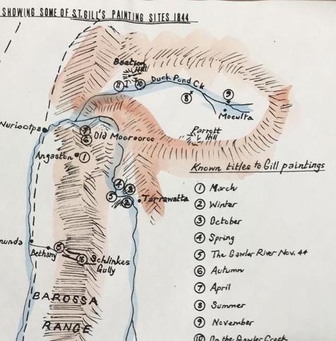
In the 1980s Ralph Grandison was mapping #S_T_Gill's artworks in #SouthAustralia. I recently viewed in the State Library his 1991 paper on Gill's 1844 #Barossa works. Interestingly he's included many of "The Seasons and The Months" - see image snippet. Clearly he didn't accept Appleyard & Radford's 1986 redating of these from 1847 to 1840-42. #artHistoryAU #colonialArtAU #historicalMapping

Over the next few months, I'll need to supplement my earlier work with Grandison's insights at: coombe.id.au/S_T_Gill/S_T_Gill

Part of a hand-drawn sketch map in black ink and watercolour, showing rivers, mountains, towns and numbered locations for the artworks which are listed in the map legend.
2025-05-13

@skatercat ⬆️ #historicalMapping on brick wall!

2025-01-09

Welcome to my project on arguably Australia's most recognisable colonial artist, Samuel Thomas Gill. It's a blend of #catalogueRaisonné, biography, historical narrative and map atlas. The scope is from Gill's arrival in #SouthAustralia in 1839 up to his early time at the Victorian gold diggings in 1852-53.

Project update: Six articles on the diggings are now complete except for pending visits to Sydney and Adelaide to check on some undigitised sources. Good progress on at least two articles for 1839-1844 gap.

Later this year I'll write some more reflective material and some of particular interest post 1853.

You can follow the hashtag #S_T_Gill for updates - you don't need to follow me.

#historyAU #1840s #1850s #VictoriaAU #colonialArtAU #historicalMapping #catalogueRaisonne #biography
coombe.id.au/S_T_Gill

2024-09-12

Historical Adelaide Maps

I'm setting free my #TroveAU lists of historical #Adelaide maps by changing them from private to public view. Originally for my research, I now make them publicly available for what they're worth. (This material found more mature realisation in interactive maps and related map articles on my website.) #historicalMapping

Adelaide City, District and County Maps, 1837 to 1851+ trove.nla.gov.au/list/130558

1842 Kingston Map of Adelaide, CWC prints and James Allen's "South Australian News-Letter" trove.nla.gov.au/list/125895

Client Info

Server: https://mastodon.social
Version: 2025.07
Repository: https://github.com/cyevgeniy/lmst