CarbonMapper - point sources of #methane and CO2 identified worldwide by Planet's Tanager satellites #earthobservation #hyperspectral #planetscope https://data.carbonmapper.org
#planetscope

Map showing areas of the Amazon with high aboveground #carbon and which parts are protected. Courtesy of Reuters and based on data from #planetscope from Planet's newsletter roundup of #2024 newsworthy imagery
https://medium.com/@planetsnapshots/issue-152-2024-in-satellite-images-ce589747a868
If you would like to help protect some Peruvian #rainforest there is a chance to directly contribute here #conservation https://give.unityvalues.com/wildlifecorridor
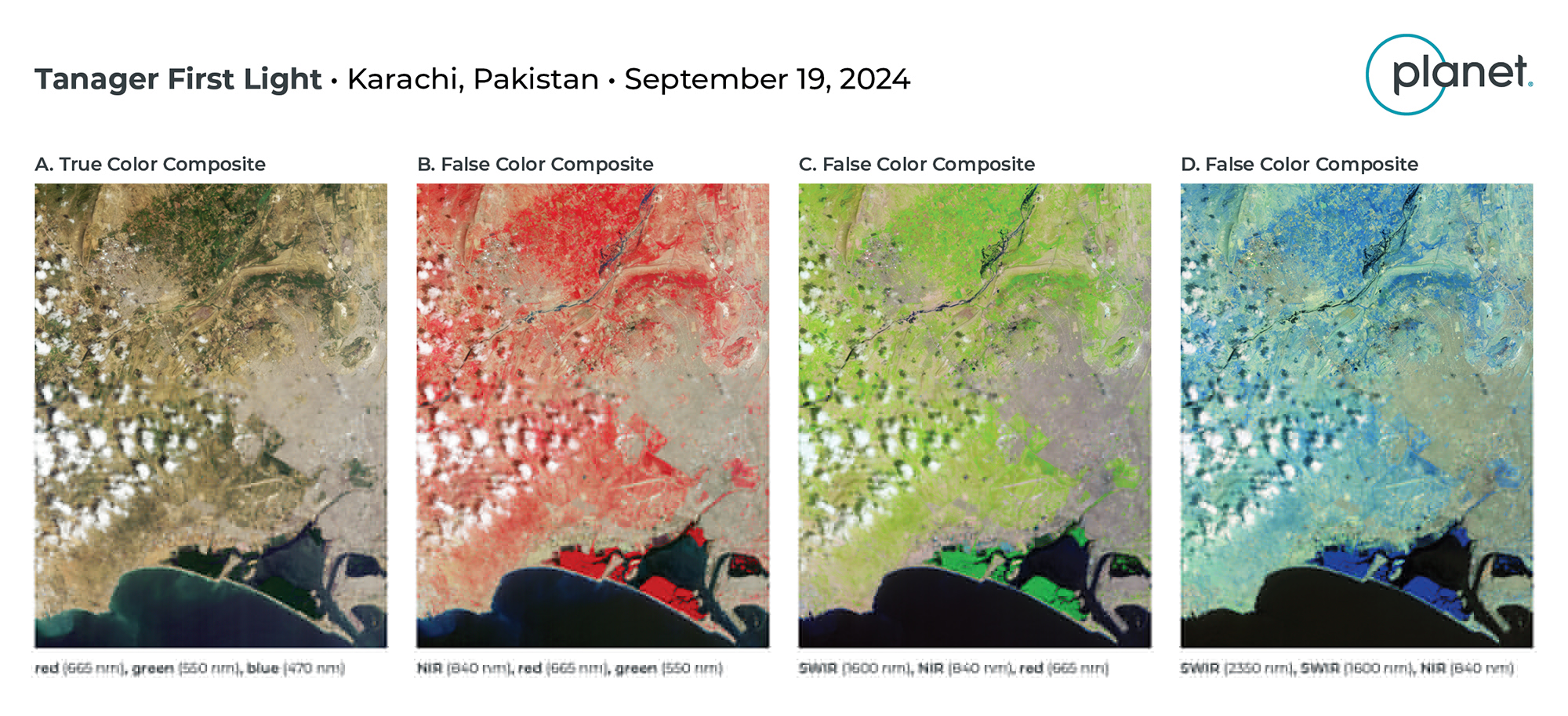
#planetscope now has a hyperspectral satellite #tanager1 with 420 bands and 30m pixel size. Something I would not have thought possible when I started in #earthobservation . It's expected to be useful in detecting #methane plumes.
If any of you read the #Narnia books as children, do you remember a scene in "Prince Caspian" when Aslan is returning to Narnia and they come to the Bridge (formerly Ford) of Beruna where a river god calls out "Hail, Lord, Loose my chains". Something like that really happened for the Klamath River in Oregon! Check out the latest Planet Snapshots https://medium.com/@planetsnapshots/issue-140-algae-blooms-klamath-dam-removal-glacial-rivers-f32eeec8227c #PlanetScope #Klamath #DamRemoval
What do they mean by Analysis Ready Data in #earthobservation and how does it apply to #Landsat, #Sentinel-2, #Planetscope....Either do tons of reading and attend hours of workshops or read this synthesis that Akis Karagiannis has kindly put together https://www.spectralreflectance.space/p/the-challenge-of-analysis-ready-data-in-earth-observation-d978ea1df97 #HLS #AnalysisReadyData #GlobalLandImaging
Burned Rohingya villages in Myanmar investigated with FIIRMS, #Planetscope, and Sentinel-2 #earthobservation
https://insightmyanmar.org/burmadhammablog/2024/6/26/they-left-a-trail-of-ash
Is there a public STAC for @planet's #PlanetScope Visual Basemap?
Breakthrough in #TropicalForests degradation making using #PlanetScope NICFi data and #deeplearning https://ctrees.org/news/a-breakthrough-in-measuring-tropical-forest-degradation
Interesting work! Mapping #trees outside #forests is essential, since a large part of #carbon projects are in grasslands and #agroforestry. #Canopy cover, height, and #ABG maps for the entire #European continent from 3-m resolution #PlanetScope 🛰️🌳
https://www.researchsquare.com/article/rs-2573442/v1
Smoke from the Chile🇨🇱 #wildfires in the valleys of the Andes east of Linares as seen by
Planet #planetscope 🛰️on 5 Feb. #IncendiosForestales
Wildfire🔥 smoke in valleys around Nevados de Chillán, Chile🇨🇱 seen on 5 Feb by
@Planet
#planetscope 🛰️ #chilewildfires #IncendiosForestales
RT @sentinel_hub: 🔴 Everything you need to know about the latest features and changes in #EOBrowser 🌐 New data, @planet #PlanetScope subscription, multi-language support, #timelapse and #3D improvements, advanced #Sentinel-1 options and more. 🤩
☝️ Read our blog post! ➡️ https://medium.com/sentinel-hub/eo-browser-updates-summer-2022-ab0d0e58d937
🐦🔗: https://nitter.eu/CopernicusEU/status/1562794640570720264
Client Info
Server: https://mastodon.social
Version: 2025.04
Repository: https://github.com/cyevgeniy/lmst