
Mahjong Solitaire Game Kit #Mahjong #Solitaire #Gamekit #Unity #3Dtiles #Gamedevelopment #Customization #AssetStore
#3DTiles

Der Weg zum Digitalen Zwilling: #3DTiles mit #OpenSource 💪
🗺️ 3D Tiles sind der Standard für Web-Visualisierung großer 3D-Daten – doch die Konvertierung birgt technische Hürden.
Martin Alzueta teilt auf der #FOSSGIS2026 Praxiserfahrungen: GLB/OBJ, LAS/LAZ, CityGML & die Frage – wie zuverlässig ist eine reine Open-Source-Toolchain? ⚙️
📅 Do, 26. März | 14:15 Uhr
📍 Raum HS3 (ZHG 009)


@wheregroup Sehr nice! Welche #OGC 3D Tiles Client Library nutzt ihr dafür? Cesium? Oder gibt es mittlerweile auch andere offene 3D Geo/Vis Libraries die #3DTiles können?
Punktwolken im Browser: 3D-Scans interaktiv erleben ☁️
Ob Bauwerksanalyse, Denkmalschutz oder Waldmonitoring – mit MapComponents lassen sich Punktwolken direkt im Browser visualisieren, ganz ohne Plugins.
Unsere Demo zeigt eine mit dem iPhone erzeugte Punktwolke in Echtzeit – inkl. Anpassung von Farbe & Punktgröße:
https://mapcomponents.github.io/react-map-components-apps/pointcloud/
Für große Datensätze nutzen wir #3DTiles – den offenen Standard für performantes Streaming von 3D-Geodaten. 🗺️
Mehr dazu im Blog: https://wheregroup.com/blog/details/integration-moderner-3d-technologien-in-web-karten-mit-mapcomponents/


Hamburg in 3D with #MapComponents!
Our 3D Tiles Layer demo showcases Hamburg’s LoD3.0 city model on a #MapLibre map. Thanks to the GPU-powered #deckgl Tile3DLayer, even large 3D datasets are rendered smoothly.
🔹 Seamless #deckgl & #MapLibre integration
🔹 Efficient 3D data visualization
🔹 Highly flexible for custom adaptations
👉 Try it now: https://catalogue.mapcomponents.org/de/component-detail/3dTilesLayer
🌍 Data: https://www.hamburg.de/politik-und-verwaltung/behoerden/behoerde-fuer-stadtentwicklung-und-wohnen/aemter-und-landesbetrieb/landesbetrieb-geoinformation-und-vermessung/produkte-und-dienstleistungen/geodaten-des-lgv/3d-stadtmodell-244116

Gaia3D has launched a 3D weather visualization system for Korea Meteorological Administration. Forecasters can now explore LDAPS & ECMWF data in 3D via CesiumJS, powered by OGC 3D Tiles & Marching Cubes. #DigitalTwin #Gaia3D #CesiumJS #3DTiles
Our team at Gaia3D developed new algorithms to boost efficiency in triangle reduction and geometry simplification for realistic mesh processing in #mago3DDTiler, and the results speak for themselves!
So much has happened in the last 3 months :) We have released many exciting tools for 3D on web maps or multi-screen working - like the "PointCloud on World Map" or the "3D Tiles Layer Demo". And quite impressive (at least technically, if not visually) is the "Multi-Tab Demo".
1. https://catalogue.mapcomponents.org/en/component-detail/PointCloud
2. https://catalogue.mapcomponents.org/en/component-detail/3dTilesLayer
3. https://catalogue.mapcomponents.org/en/component-detail/MultiTab
All open source and available on Github: https://github.com/orgs/mapcomponents
#OpenSource #webgis #3d #pointcloud #3dtiles #deckgl #MapComponents

Even without textures, buildings can look beautiful if they are painted appropriately with purpose-driven colors.


Hey, gamedev mastodon, I read an article a couple of years ago by someone who was working on a game where the city scape was constructed from 3D tiles. The article went into a lot of detail about how the tile set was designed to be very modular. The technique was interesting. However now I can't find that article. Does this strike a memory for anyone? I think the game itself might have has some sort of mechs as a component.
"Building a Digital Twin Service in 10 Minutes with FOSS4G!" showcased at KSIS(Korea Spatial Information Society) Spring Conference.
Yesterday I've showcased "How to Build a Digital Twin Service in 10 Minutes with Open Source!" at the KSIS(Korea Spatial Information Society) Spring Conference. Unfortunately it took 10 minutes and 50 seconds. In light of this, I will humbly change the presentation title to "Building a Digital Twin Service in 11 Minutes." Lesson learned! #DigitaTwin #mago3DTiler #mago3DMesher #3DTiles


mago 3DTiler allows effortless conversion of a variety of 3D formats including 3DS, OBJ, FBX, Collada DAE, glTF, IFC and more to OGC 3D Tiles even with SHP extrusion and CRS conversion and LAS addition #3dtiles
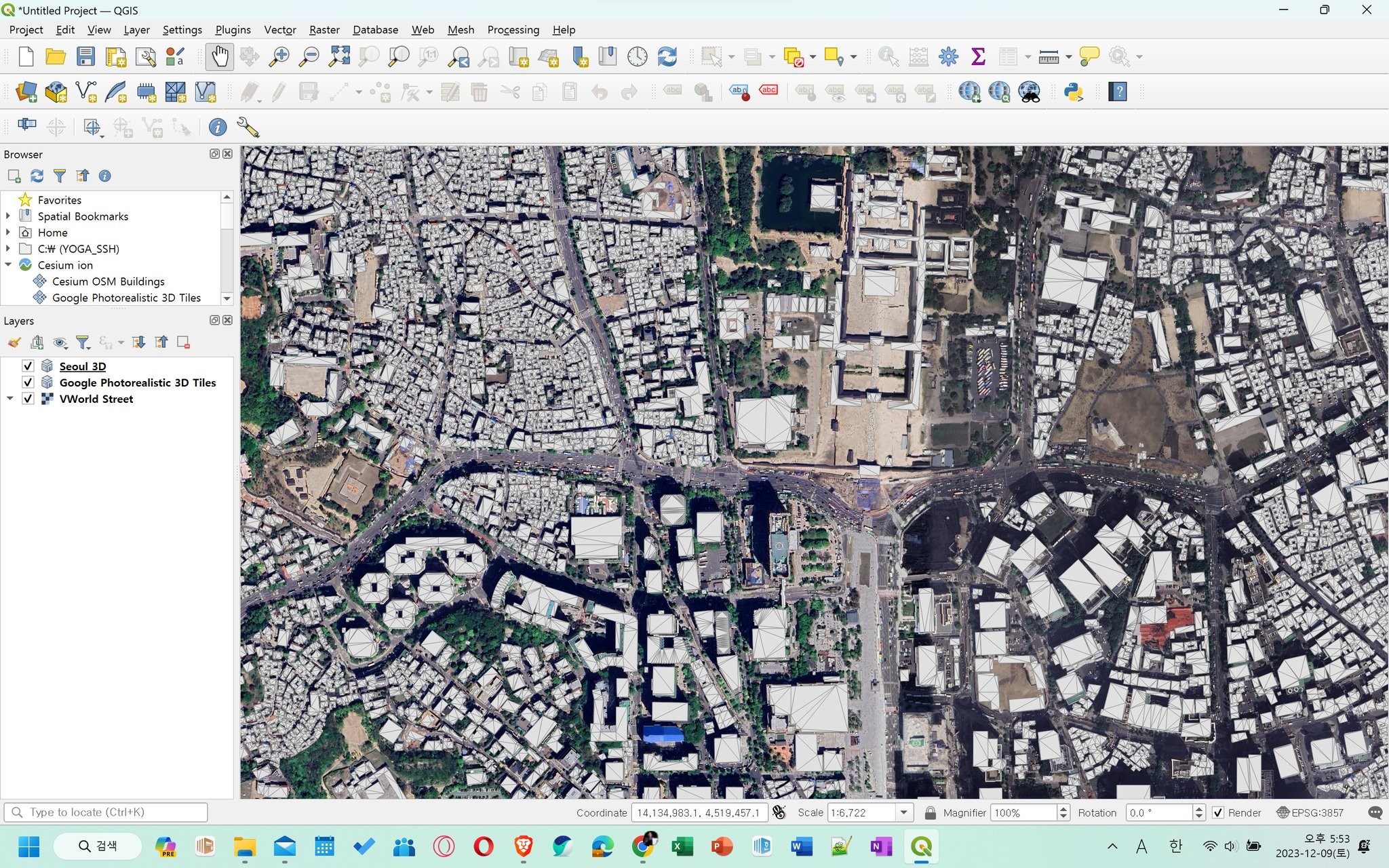
Google Photorealistic 3D Tiles x Seoul 3D Tiles x OpenStreetMap on #QGIS
Seoul 3D Tiles was created using mago 3D Tiler, an open source OGC 3D Tiles Converter. https://github.com/Gaia3D/mago-3d-tiler
표준의 힘은 이런 거다. 구글에 있는 전 세계 3차원 객체 자산과 내가 만든 3차원 객체와 남이 만든 지도와 객체를 함께 섞어서 지지고 볶고 융합하고 새로운 것을 만들어 낼 수 있는 것. 우리나라 디지털트윈 사업이 외산 오픈소스에 점령당하고 있다는 희한한 소리도 들었는데 그건 프레임이 잘못된 것다. 외산 오픈소스에 점령당한 게 아니라 국제표준을 지원하는 오픈소스를 사용하는 것일 뿐. 외산이냐 국산이냐가 아니라 국제표준을 지키는가 아닌가가 문제의 핵심이다.

mago 3DTiler로 변환한 왕숙2지구 3D Tiles를 QGIS에서 띄워봤습니다. 잘 뜨네요. 근데 웹 브라우저로 보는 게 더 빠르고 예쁘다는 게 함정이네요. ㅎ
Produced by open source mago 3DTiler and consumed by open source QGIS and Cesium.js. Want to experience? Try this: https://github.com/Gaia3D/mago-3d-tiler


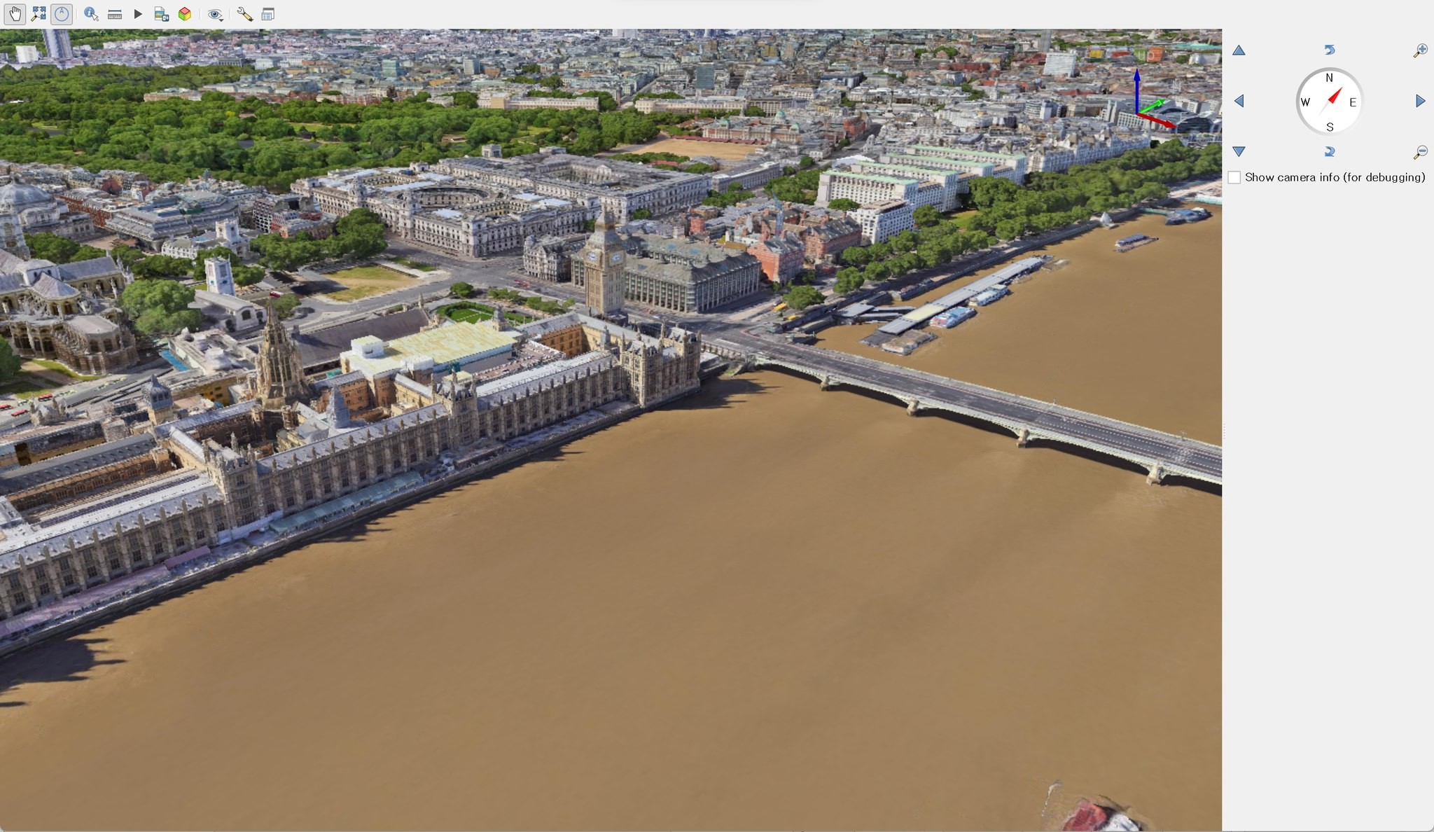
New video: #3DTiles and the #Cesium ion plugin in #QGIS. Thanks @northroadgeo and @lutraconsulting for making this available in QGIS 3.34 Prizren! https://youtu.be/7ipjZ8_LCMk

TIL how to get #3DTiles in #QGIS 3.34
Pretty impressive! More details in this post by @nyalld: https://north-road.com/2023/11/07/qgis-3d-tiles-thanks-to-cesium-ecosystem-grant/

Client Info
Server: https://mastodon.social
Version: 2025.07
Repository: https://github.com/cyevgeniy/lmst