#US Forest Service downsizes, loses 15% workforce Firefighters face shortages after 1,500 support staff leave, critics say #USFS says firefighters ready for above-normal fire year prediction
#USFS
All-female ‘Forest Corps’ fills federal agency gaps for Wyoming trail projects
A Bridger-Teton nonprofit created the team of former federal staffers in the wake of DOGE cuts to assist depleted Forest Service field crews.
#Wyoming #WY #USFS
wyofile.com/all-female-f...
All-female ‘Forest Corps’ fill...
https://youtube.com/watch?v=cmRJ8Y7clbA&si=jks7K9G3470YkgUA
Great video on roadless areas around #lassenpark in #EasternCalifornia by a forest manager and cartographer.
Logging risked areas may not help with fire and land management. There's a lot of nuance that goes into proper stewardship of forests, highly managed forests of dense monocrop trees burn hotter than less continuous and varied stands actively managed with prescribed fire.
#USFS #logging #LandManagement #ProtectOurPublicLands #forestry #GIS
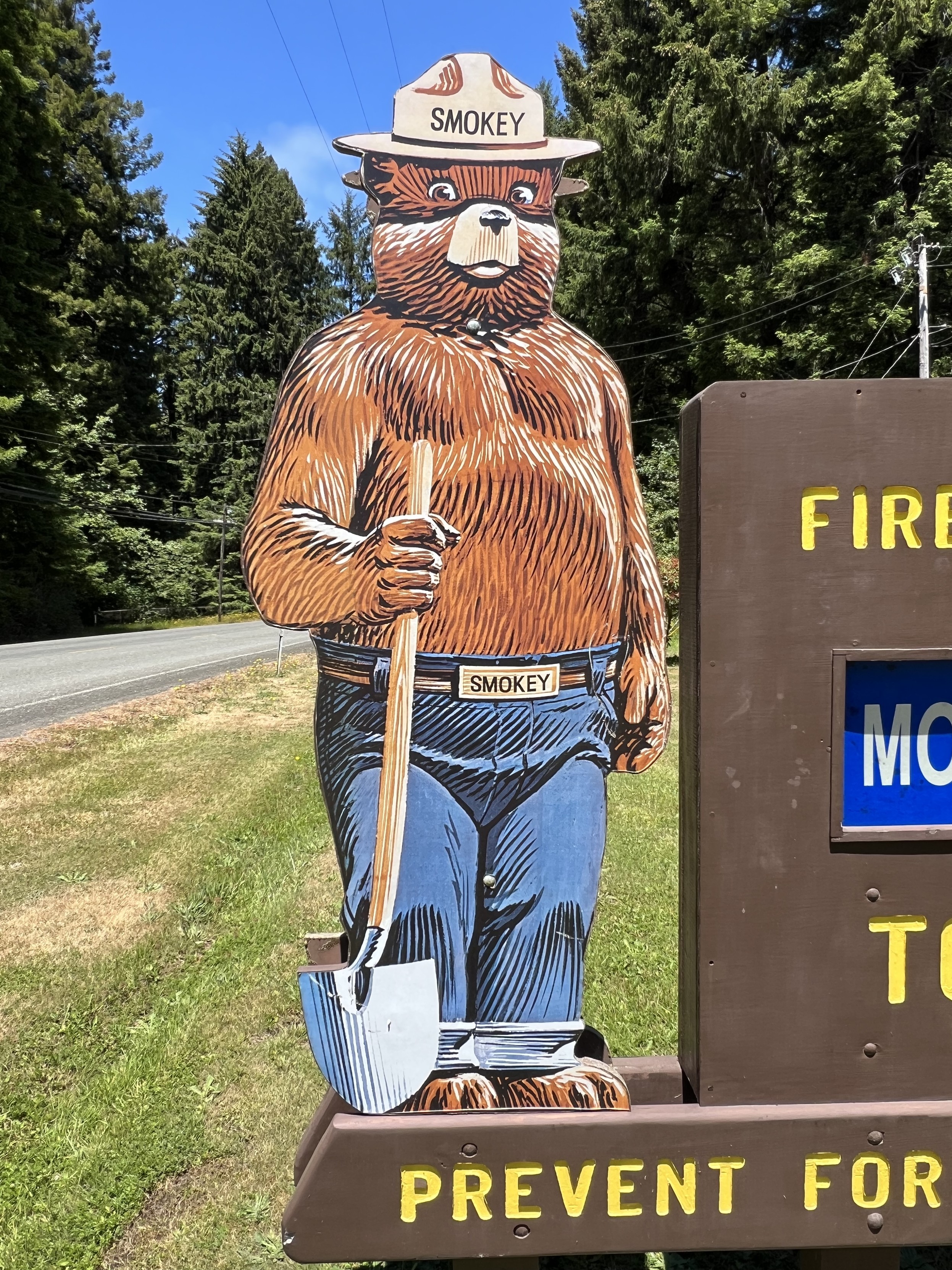
Fire Danger Rating Sign and Smokey Bear in Trinidad, California, yesterday. Image credit Kurt Angersbach / Westernlabs. Learn more at https://smokeybear.com/en/smokeys-history?decade=1940 and https://research.fs.usda.gov/firelab/projects/firedangerrating#:~:text=The%20National%20Fire%20Danger%20Rating,and%20simplify%20fuel%20model%20inputs. and https://www.fire.ca.gov/ and #smokeybear #forest #publiclands #photography #newtopographics #usfs #forestservice #smokey #calfire #nfdrs #sign #california
#TheGremlinZoo #GOP #Budget #USFS
From AP.com: GOP plan to sell more than 3,200 square miles of federal lands is found to violate Senate rules
https://apnews.com/article/public-land-sales-senate-mike-lee-bf4c3a046a107efc7d4ffe005fdb9d2d
#TheGremlinZoo #RoadlessRule #USFS
From NPR.org: Trump to rescind 'Roadless Rule' protecting 58 million acres of forest land
more details on the proposed public land sale:
https://wessiler.substack.com/p/a-simple-guide-to-the-great-public
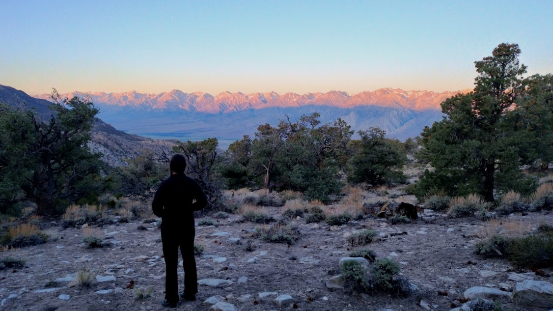
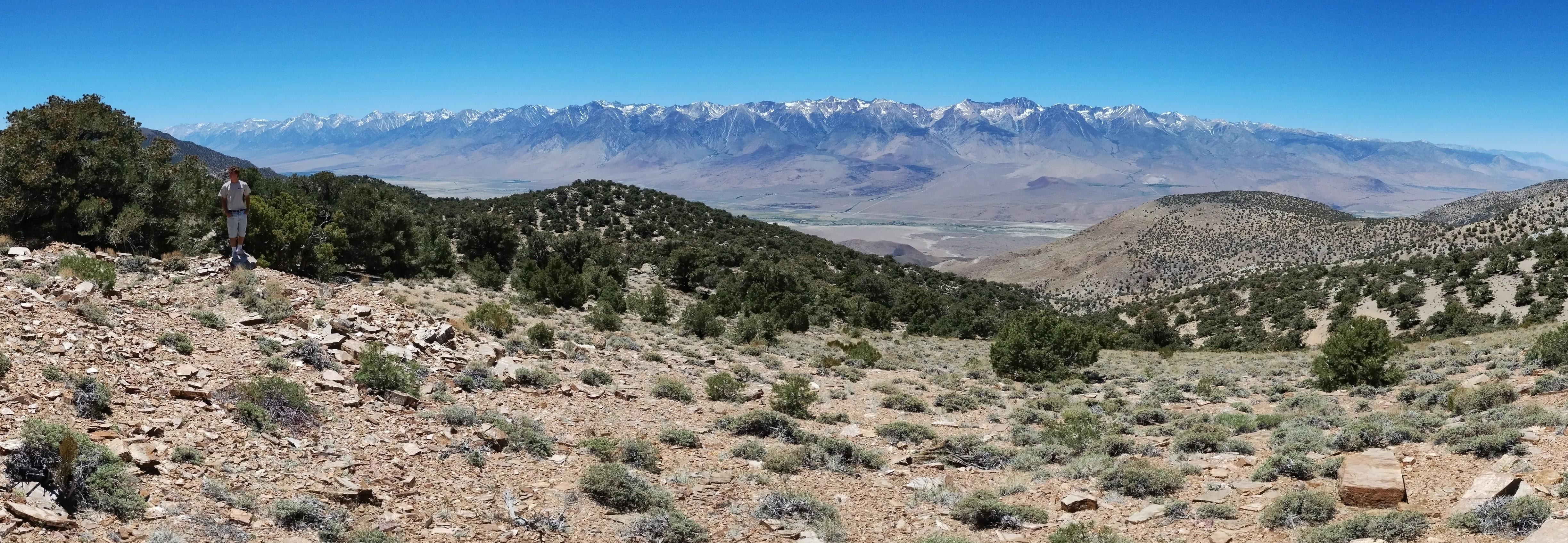
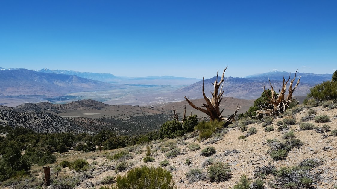
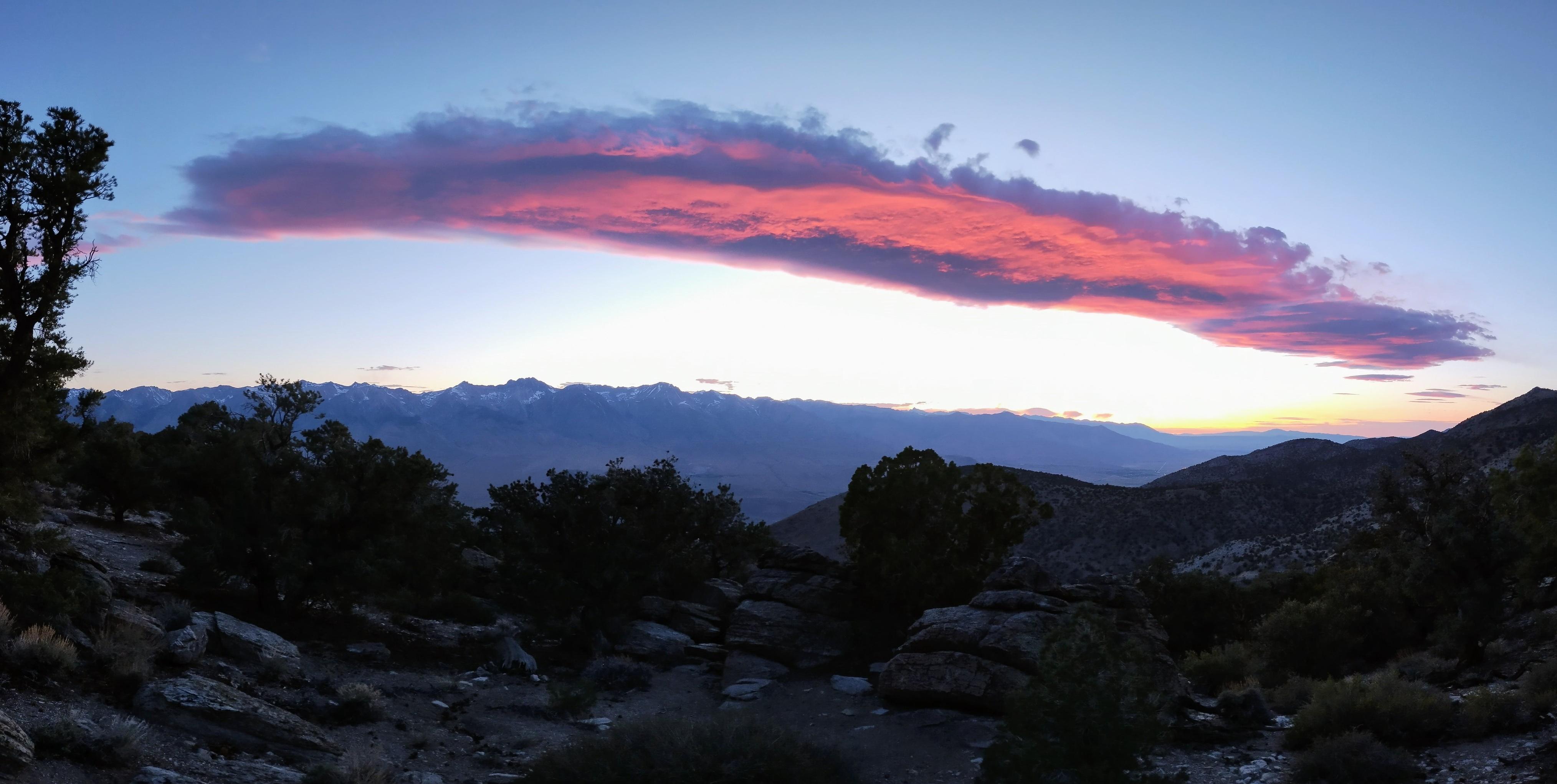
All of this area of the Inyo Mountains where we camped last weekend is possibly on the chopping block, proposed for sale under the Big Ugly Bill. It could be privatized, mined, logged, access removed. We saw plenty of evidence of Native American use, big horn sheep passing through, historic structures and remnants. It is a truly special place that needs to be preserved. #InyoMountains #InyoNF #USFS #PublicLands #BigUglyBill
wait, what? selling off over 3 million acres of public land?
that's a lot of land. take a look and see!
https://www.arcgis.com/apps/instant/basic/index.html?appid=821970f0212d46d7aa854718aac42310
https://www.publicdomain.media/p/federal-land-sales-senate-budget-mike-lee
including areas near the Boundary Waters Canoe Area (BWCA)? NOPE. No. NO.
what do you think will happen when the land is clear-cut and/or mined? erosion, water contamination, etc. that stuff isn't an easy fix. much easier to protect it now.
Republicans want to sell *your* land.
h/t @downriver
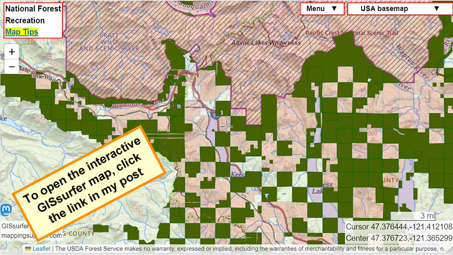
Vast amounts of public land are proposed for sale.
Red = Public land owned by you/me/everyone and managed by the US Forest Service
Dark green = Senate reconciliation bill says this public land can be sold. This data layer is *slow* to load.
Diagonals = Designated #wilderness will remain as-is.
When the map opens it is centered near Snoqualmie Pass, Washington State. The data the map can display covers all the USA.
To search on an address or town, open the map and click Menu > Search.
Thanks to the Wilderness Society for hosting the GIS data showing land that will be available for sale per the current reconciliation bill. Here is their article:
https://www.wilderness.org/articles/media-resources/120-million-acres-public-lands-eligible-sale-senr-budget-reconciliation-package
#USFS #Hiking #Camping #PublicLand
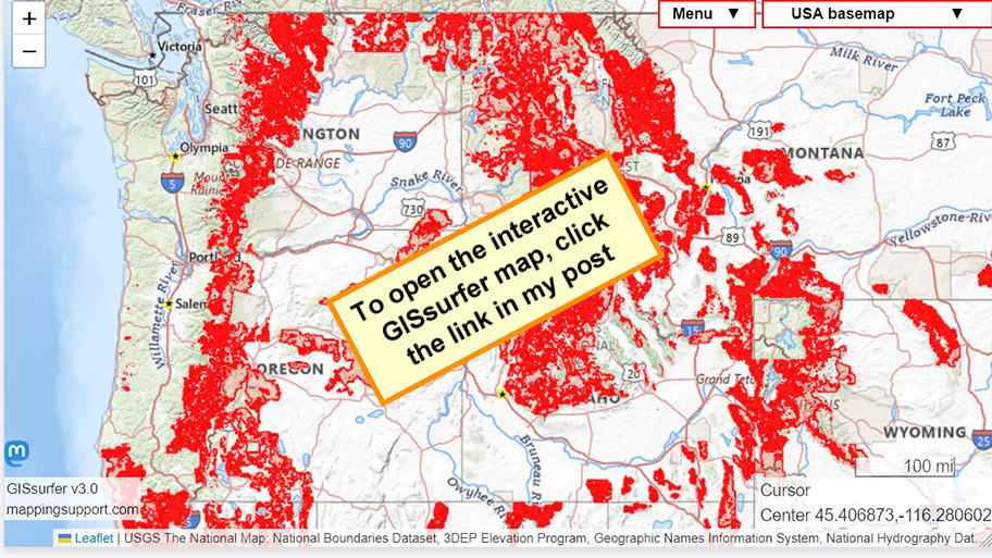
Big increase in logging in the national forests??
See the underlined links in this story. No paywall.
https://www.sfgate.com/la/article/california-national-forests-logging-20263873.php
But if existing mills are running at capacity then it is unclear if a big increase in the rate of logging in the national forests will actually happen.
The USFS ArcGIS server has a layer showing the USFS land where a big increase in logging is intended to happen. That data is shown as red on this map.
To search on a town or address, click Menu > Search.
#Camping #Hiking #Fishing #USFS #NationalForest
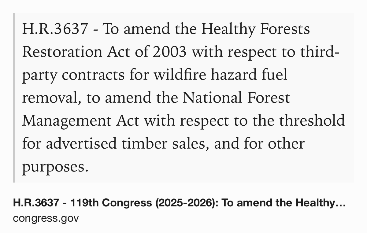
H.R.3637, sponsored by Rep. MaMalfa, is probably intended to make it easier to contract out fuels management. Since, you know, the USFS lost over 1600 people so gotta start privatizing that work at far more expense #USFS #USPol https://www.congress.gov/bill/119th-congress/house-bill/3637
Reader mode can get beyond the JavaScript paywall… “Arizona's Coronado Forest open to logging under new federal plan” https://tucson.com/news/local/subscriber/article_482bf212-034d-4415-bef1-1bab425e9061.html #USFS
NPR: Trump's Forest Service cuts have people in tinder dry New Mexico on edge https://www.kpbs.org/news/national/2025/04/17/trumps-forest-service-cuts-have-people-in-tinder-dry-new-mexico-on-edge
Working on damage assessments for a heavily flooded area of our state. Then I remembered that the headwaters had burned over last summer, meaning increased runoff, faster snowmelt, etc. So I logged on to USDA's Burn Severity Portal... And all the past fire reports appear to have been deleted including recently completed ones from last summer's fires. Many links are dead.
I'll try contacting the forest offices to see if we can get a backup. This is a critical resource for the environment, our health, life, and safety.
I am at a loss, mad, and sad. These actions being taken are making our jobs and lives so hard and truly hurting everyone regardless of ideology.
"This action builds on Secretary Rollins’ announcement last month to unleash American energy by directing the USDA Forest Service to take action to remove burdensome Biden-era regulations that have stifled energy and mineral development on Forest Service land. As part of these decisive actions, the agency also canceled two mineral leasing withdrawals on Forest Service land that will help boost production of critical minerals." https://www.usda.gov/about-usda/news/press-releases/2025/04/04/secretary-rollins-announces-sweeping-reforms-protect-national-forests-and-boost-domestic-timber #USDA #USPol #USForestService #USFS
#Climate
Mono Lake and the Owens Valley today. Image credit Great Basin Unified Air Pollution Control District. For more information https://www.gbuapcd.org/District/AboutUs/ and #nps #nationalparks #usfs #nationalforests #interpretation #publiclands #photography #landscapephotography #newtopographics #geology #geography #clouds #california #airquality #mountains #snow #lakes #infrastructure #monolake
#NCwx #NorthCarolina #Wildfires #USFS #RattlesnakeBranchFire
2/2
.. Firelines create an area of bare soil and act as a buffer to slow down or stop fire progress. Firefighters are engaging tools such as small bulldozers and leafblowers to remove fuel.
State Highway 276 remains open but please drive carefully- firefighters and equipment are working in the area.
The fire started on private land and is under investigation.
Client Info
Server: https://mastodon.social
Version: 2025.04
Repository: https://github.com/cyevgeniy/lmst