Arga

He /him, adult, taken, soldier, goat, ZH in CH, Eng /Ger /Fra

Geology and geography by education /history by interest. Expect anything when following. I will do photography, map-making and other things I'll post about here.

I stream sometimes twitch.tv/argacyan and on Youtube youtube.com/@Argacyan/featured

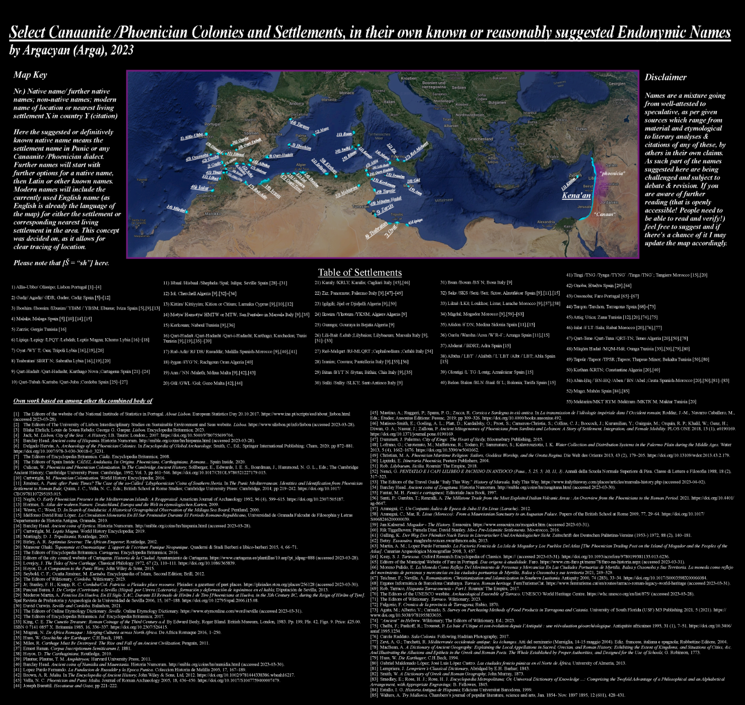
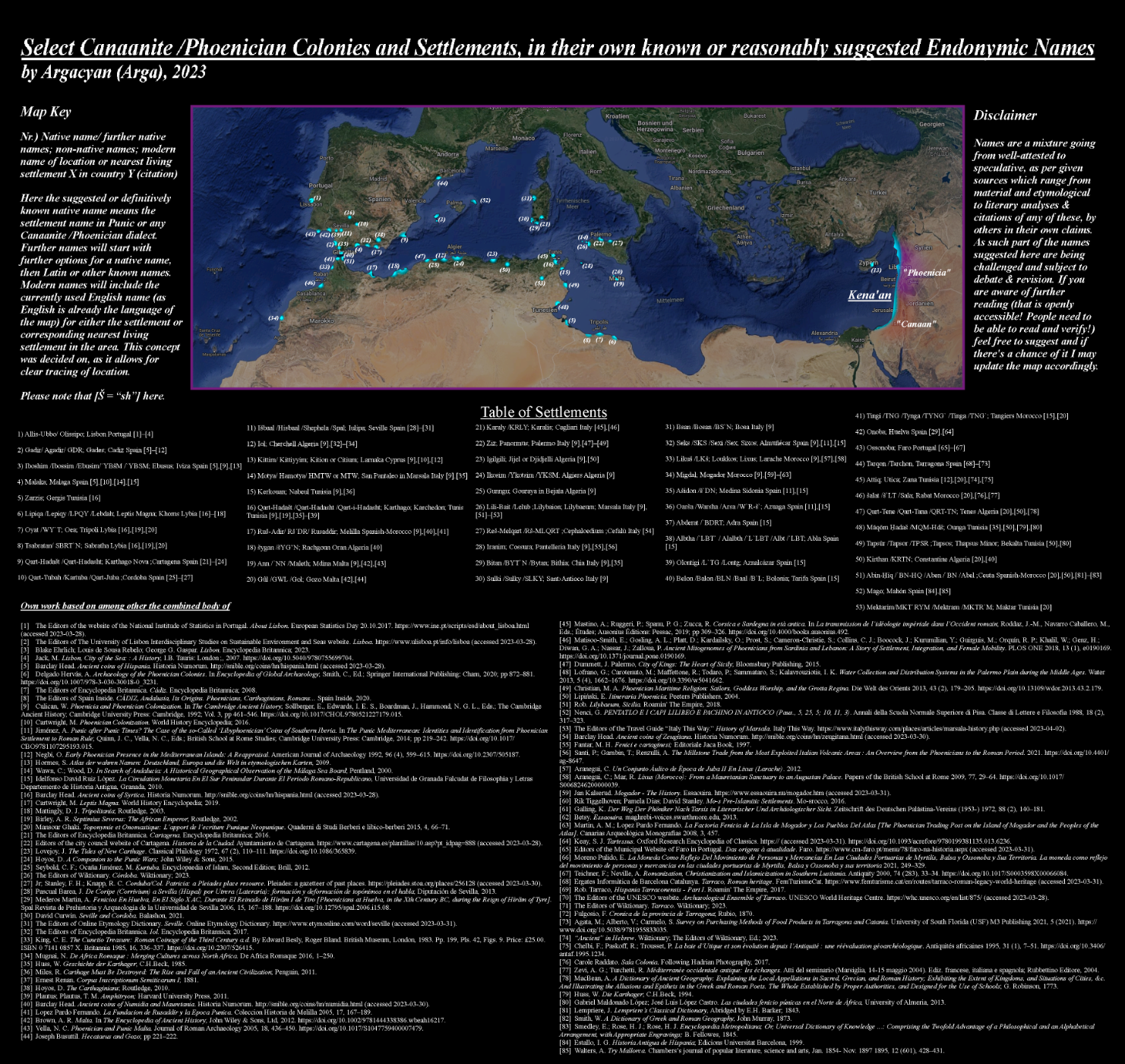
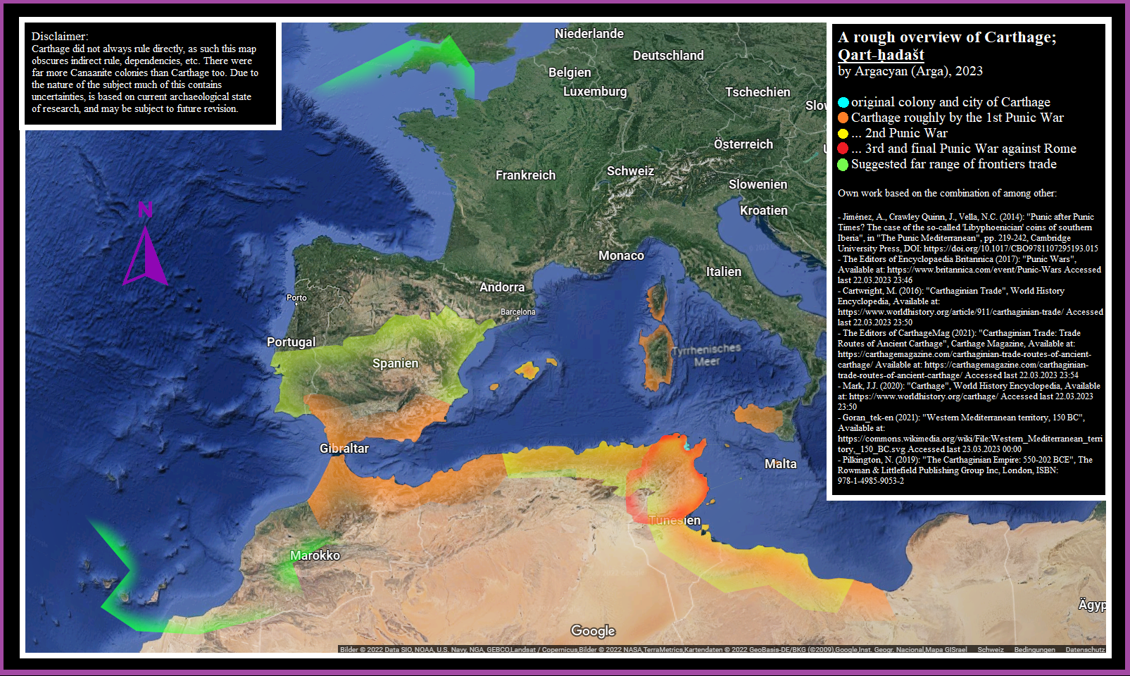
Backup Nr.10 of "Map showing select #Phoenician / #Canaanite colonies and settlements with their known or reasonably suggested endonymic names"

[Description cut due to character limits]

#map #maps #classicalantiquity #phoenicians #mediterranean #europe #northafrica #africa #levante #cyprus #spain #portugal #morocco #algeria #tunisia #lybia #italy #punic #semitic #antiquity #historicalmaps #history #carthage #mapstodon #histodon #histodons

Map showing select Phoenician  / Canaanite colonies and settlements with their known or reasonably suggested endonymic names. Version A, indicating the first native name next to its location on the map.Map showing select Phoenician  / Canaanite colonies and settlements with their known or reasonably suggested endonymic names. Version B, indicating only the reference number next to settlement location on the map. This version is for if version A is too hard to read.

Backup Nr.9 of "Map depicting the original colony & city of #carthage as well as the #CarthaginianEmpire at 3 more points in time, and also a suggested far range of frontiers #trade between it & other areas from #NorthAfrica to #britain "

As always further information is embedded on the image itself.

#maps #map #HistoricalMaps #history #antiquity #classicalantiquity #PunicWars #punic #phoenicians #europe #africa #semitic #histodons #histodon

Map depicting the original colony & city of Carthage, as well as the Carthaginian Empire at 3 more points in time, and also a suggested far range of frontiers trade between it & other areas from north Africa to Britain.

Backup Nr.8 of "Map of #AustriaHungary in the late #19thcentury , showing the major divisions #cisleithania and #transleithania as well as their subdivisions, also showing co-administered #bosnia and indicating the then-recently lost #LombardyVenice "

#maps #map #HistoricalMaps #history #europe #austria #hungary #ukraine #czechia #slovakia #slovenia #italy #romania #croatia #balkan #danube #victorian #tirol #Moldovia #moldova #moldawien #osterreich #ungarn #magyarorszag #histodon #histodons

Map of Austria-Hungary in the late 19th century , showing the major divisions cisleithania and transleithania as well as their subdivisions, also showing co-administered bosnia  and indicating the then-recently lost Lombardy-Venice

Backup Nr.7 of "Map of the Crimean Khanate at 4 points in time, shown as a superposition of borders layed above each other for comparison"

[Description cut due to character limits]

#crimea #CrimeanKhanate #tatar #tataren #russia #ukraine #donbas #medieval #renaissance #colonialism #imperialism #map #maps #mapping #HistoricalMaps #history #histodon #histodons

Map of the Crimean Khanate at 4 points in time, shown as a superposition of borders layed above each other for comparison. The area of this country is split between Ukraine and Russia on the modern Google Maps basemap. Notable is also that only the least old timestamp has a clearly defined border.

Backup Nr.6 of "The Roman province of Rhaetia around 200ad, according to Gustav Droysen (1886) based on Claudius Ptolemy"

#map #maps #romanempire #rome #germania #germany #austria #switzerland #GreyLeagues #RhaetoRoman #alps #classicalantiquity #antiquity #historicalmaps #histodon #history #histodons

Map depicting the Roman province of Rhaetia around 200ad, according to Gustav Droysen.

Backup Nr.4: "Map of the Alemannic linguistic group"

As always all info is embedded on the image.

Covered by this #linguistic group here on this map are the areas of #BadenWurttemberg in #germany most of the land of #Switzerland , #Elsass or #Alsace currently in #france the #Vorarlberg in #austria as well as certain valleys in northern #italy

#language #europe #german #alemannia #Alemannisch #alemannic #deutsch #deutschland #schweiz #LinguisticMaps

Map depicting the Alemannic linguistic group and its subdivisions. Covered by this group are the areas of Baden-Würtemberg in Germany, most of the land of Switzerland, Elsass /Alsace currently in France, the Vorarlberg in Austria, as well as certain valleys in northern Italy.

Backup Nr.3 "Artistically styled map of Switzerland showing majority language by voting district"

...of all 4 official languages. All information is again embedded on the file, source is BFS or Swiss Governmental Department of Statistics.

#europe #switzerland #swiss #map #maps #LinguisticMaps #german #french #italian #RhaetoRoman #latin #alps #alemannic #arpitan #lombard #language #linguistics #linguistic

Map of Switzerland artistically styled by main language in voting district. Source given on image file is the BFS or Swiss Governmental Department of Statistics.

Backup Nr.2

Here are the same 4 maps of Pomerania as in the above post, as individual image files. Same as before all of the information & citations are on the images themselves.

#pomerania #HistoricalMaps #maps #map #germany #german #poland #sweden #europe #medieval #renaissance #prussia #brandenburg #mecklenburg #stettin #wolgast #Kammin #histodon #histodons

Map of regional Pomerania during the late medieval period. Depicted are the countries of Stettin, Wolgast, Kammin as well as the border towards Pomerellia which is excluded from the term Pomerania here.Map of Pomerania during the 30 Years' War. Depicted are the Duchy of Pomerania as well as Rugia in particular, which was under Swedish occupation.Map of Pomerania at the start of the Napoleonic period. Depicted are Hither- & Farther Pomerania which was under the Kingdom of Prussia, as well as Swedish-Pomerania.Map of Pomerania around the year 1900 before World War 1 and after the Franco-Prussian war of German Unification. Depicted is the Province of Pomerania under Prussia, as part of Germany.

Backup Nr.1 of "Pomerania at 4 points in time"

All necessary information & citations are embedded on the images themselves.

[deleted description due to character limits]

One image shows those 4 timestamps separately, the other image shows you a superposition of those borders for comparison.

#maps #map #HistoricalMaps #pomerania #germany #german #poland #sweden #europe #history #prussia #brandenburg #mecklenburg #histodons #histodon

Image of 4 Maps of Pomerania, showing 4 different historical borders either of Pomerania or the countries & areas that constitude Pomerania, layed above each other.Map of Pomerania, showing a superposition of 4 different historical borders either of Pomerania or the countries & areas that constitude Pomerania, layed above each other.

This post will be pinned here as a backup of the map-thread from my main instance due to reports of visibility & access problems.

It will be kept updated same as the original thread.

(Link to original: "yiff.life/@Argacyan/1101541527")

#art #maps #map #mapping #mapmaking #HistoricalMaps #GeographicalMaps #LinguisticMaps #mapstodon #histodon #histodons #HistoricalMaps

I will be mostly active on my main instance. I have put my master thread for #maps on here now & may boost any individual #map so they can appear here as well.

Client Info

Server: https://mastodon.social
Version: 2025.04
Repository: https://github.com/cyevgeniy/lmst