@lavergnetho Mermaid looks promising, Thanks for the recommendation!
Fiona Gregory
Geospatial Data Analyst specializing in Earth Observation (Remote Sensing) at the Alberta Biodiversity Monitoring Institute
What software do you like for making #flowcharts?
I used to try to do it in Powerpoint, and I hate it so much.
Fiona Gregory boosted:
You could consider today's date, 1/5/25, as 5⁰/5¹/5².
Fiona Gregory boosted:
Portraits of dismissed scientists personalize US government cuts to science: https://pubs.aip.org/physicstoday/online/44193
Fiona Gregory boosted:
Been saying for years - number 1 climate action: vote like your life depends on it. Like a liveable future depends on it.
Because it does.
During the 2000's GIS certificate programmes were sprouting up like mushrooms all over the country - I was part of the development of one of them. The graduates were in great demand. Now they are disappearing. Yet geomatics is more important than ever. Jon Murphy of GoGeomatics has some thoughts #geomatics #geography #GIS https://gogeomatics.ca/treat-geomatics-like-a-national-asset-not-an-afterthought/
@hareldan Why, what's happening?
Fiona Gregory boosted:
This is than a “chilling effect”
A few days before they were to submit a scientific paper together, an evolutionary biologist in Europe received an unexpected request from 2 co-authors in the #UnitedStates.
After much thought, the co-authors said they preferred not to risk publishing at this time.
#Trump #law #immigration #academia #AntiIntellectualism #science #research #censorship #MafiaState #Nazis
https://www.washingtonpost.com/science/2025/04/10/evolution-research-deportation-fears/
Fiona Gregory boosted:
A global map with pictures of cats in train stations. If you have a picture you want to add get in touch with @SBahnFahrer
Fiona Gregory boosted:
On March 23, a convoy of aid workers, traveling in vehicles marked with emergency flashing lights, was struck by gunfire in Gaza. Bellingcat used the video footage of the incident to perform an audio analysis of the shooting. https://www.bellingcat.com/news/2025/04/09/gaza-palestine-israel-killed-death-aid-workers-international-red-cross-crescent-audio-analysis/?utm_source=mastodon
@safest_integer It looks like a rose! Is this a super nerdy person's valentine? 😄
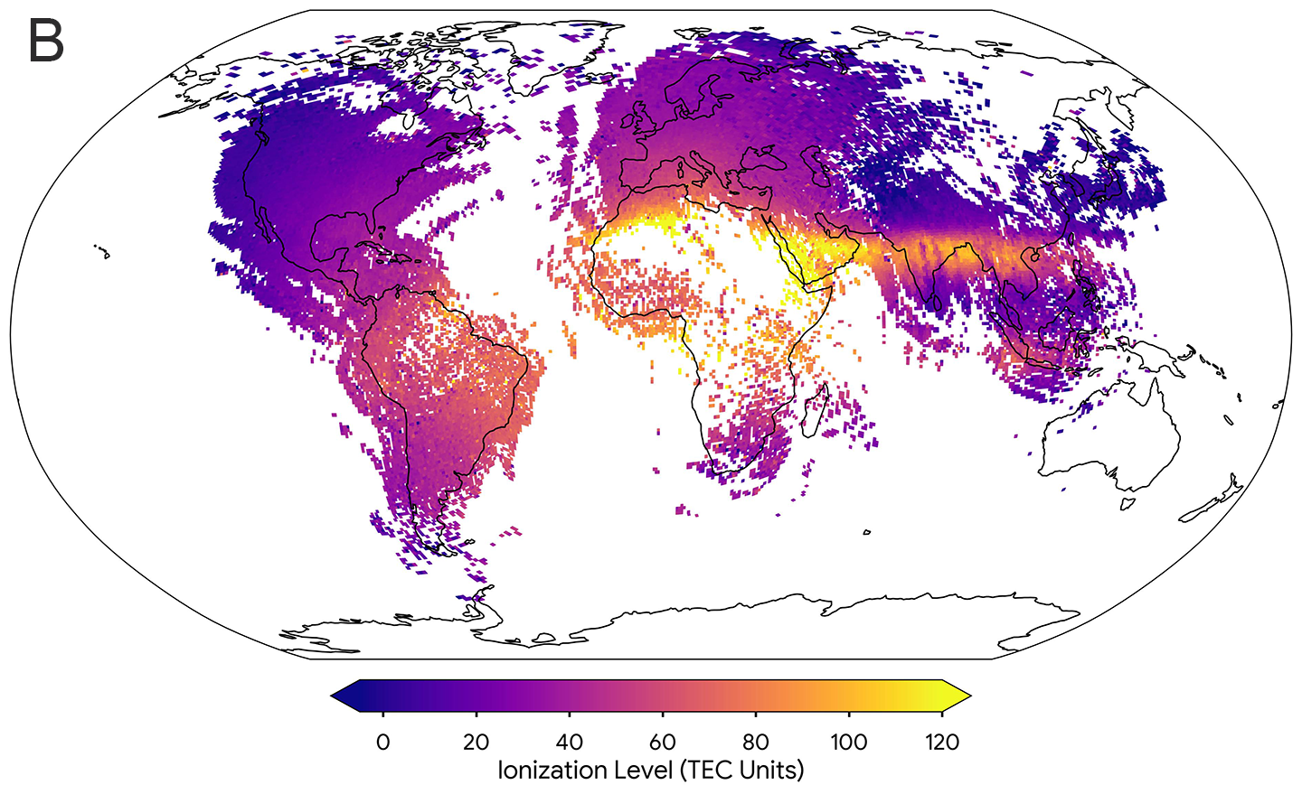
#Ionosphere map made with crowd-sourced cell phone data. Even after reading the article, I'm not quite clear on how they got the data...https://www.snexplores.org/article/ionosphere-smartphone-data-gps
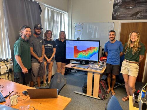
The seafloor around the remote British Overseas Territory of #AscensionIsland just got mapped, some of it for the first time ever...Looking at this cheerful looking crew in shorts , I wonder what it would be like to be one of the Ascension Island Government Conservation Team. https://gogeomatics.ca/seeing-what-lies-beneath-seafloor-mapping-in-a-marine-protected-area/ #bathymetry #marineReserve
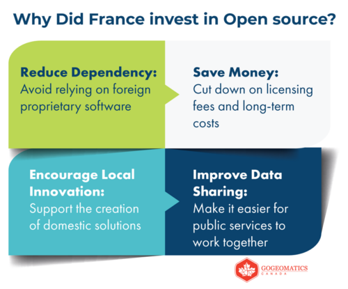
"While other nations are also adopting #open-source solutions, few have implemented them as systematically as #France...France’s commitment to open-source GIS didn’t happen by chance. There was a deliberate strategy in place. #FOSS #opensource #oss4geo https://gogeomatics.ca/frances-open-source-gis-journey-a-blueprint-for-digital-sovereignty/
The founder of geo-promoting organization #GoGeomatics #Canada reflects on Canada's past, present, and future role in #geomatics given the current geopolitical situation https://gogeomatics.ca/canada-must-leverage-its-geospatial-legacy-to-embrace-new-opportunities/ "Canada’s contributions to the global geospatial/geomatics sector are foundational. ...As trade conflicts and geopolitical upheavals challenge old assumptions, Canada must leverage its geospatial legacy to embrace new global opportunities."
Fiona Gregory boosted:
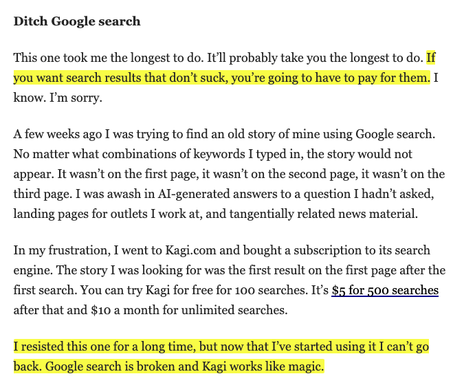
Kagi users often start with resistance but quickly realize quality search is worth the cost.
Matthew Gault shares his journey to paid search with Kagi in "The Gizmodo Guide to Stopping Algorithms From Ruining Your Life" -
https://gizmodo.com/the-gizmodo-guide-to-stopping-algorithms-from-ruining-your-life-2000584899
Fiona Gregory boosted:
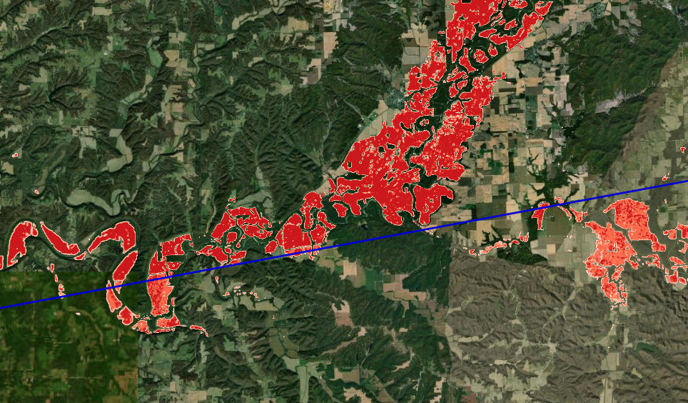
Significant, generational and historic #flooding across the Ohio River Valley following multiple days of heavy rainfall and severe storms. You can see the extent of the flooding in the Sentinel-1 #SAR derived flood mapping I made in support of operations here. I have masked out normal water detection from previous Sentinel-1 images so I'm only highlighting the floods. Sentinel-1 Acquisition Relative Orbit 121 on 6 Apr 2025 @ 23Z https://www.nohrsc.noaa.gov/special/leaflet/2025/sar_fim_20250406/index.html?x=-9541745.41895&y=4663230.60059&z=8.90728&r=0&l=1111111
@joewynne Are you sure they are not doughnuts on sticks?
Client Info
Server: https://mastodon.social
Version: 2025.04
Repository: https://github.com/cyevgeniy/lmst