
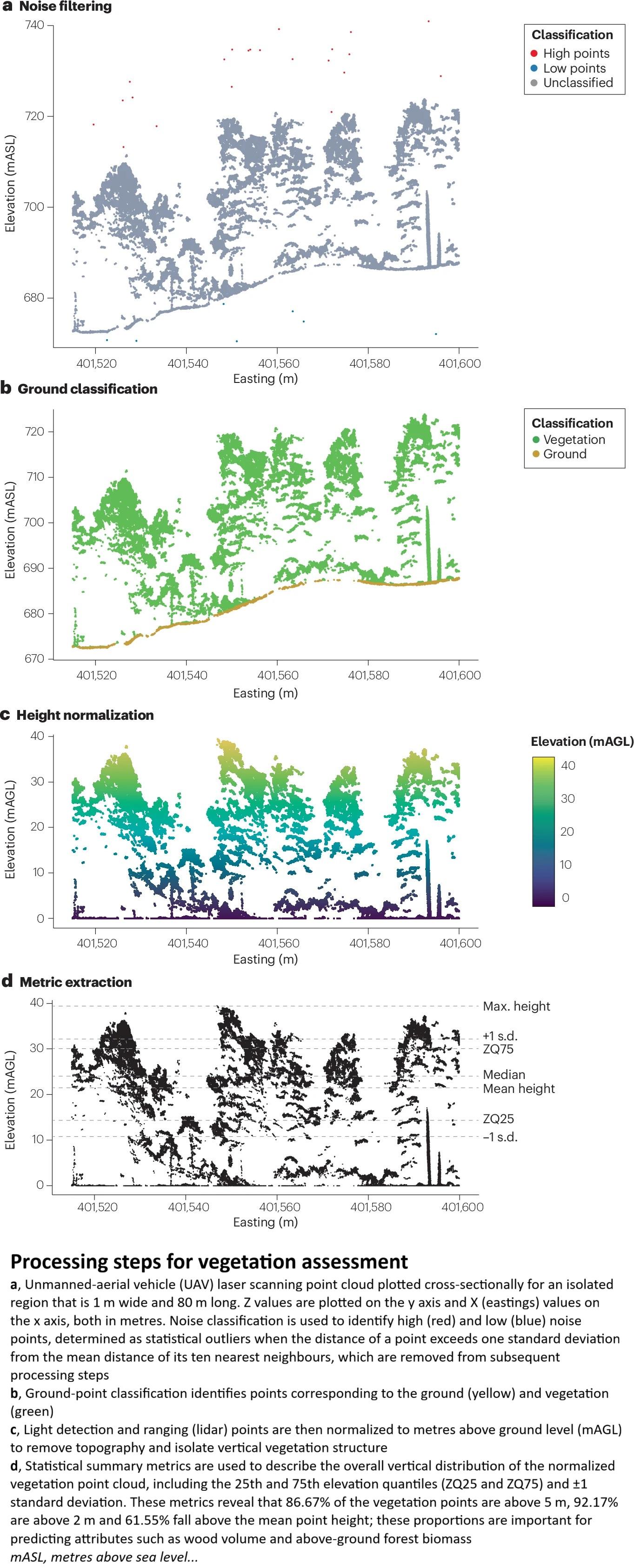
Light Detection And Ranging Of Natural Systems
--
https://doi.org/10.1038/s43586-025-00446-3 <-- shared paper
--
['primer'/'tutorial'/overview]
#GIS #spatial #mapping #remotesensing #explanation #tutorial #overview #primer #LiDAR #laserscanning #survey #pointcloud #spatialanalysis #airborne #satellite #usecase #vegetation #forest #forestry #resource #wildfire #fuel #elevation #topography #bathymetry #glaciology #glacier #workflow #naturalsystems #applications #algorithms #sensors #geomorphometry #geomorphology #drone #UAV #water #hydrology #groundbased #instrumentation #spatiotemporal #landsurface #landcover
#bathymetry


#30DayMapChallenge Day 28: Black
On this Black Friday, I found today’s theme in the depths of the Black Sea 🌊.
Using the OpenTopography DEM Downloader, I grabbed the Global Bathymetry SRTM15+ V2.1 dataset, calculated 100 m contours, and applied the Tanaka method with a style from the QGIS Hub plugin. 🎨
#QGIS #Cartography #OpenData #Bathymetry #BlackSea #GIS #Mapping

@enigma Solch Streifen hier in google maps sind übrigens nicht "echt". Das sind Artefakte der Schifffahrtsrouten. Da misst man eben genauer_
https://www.google.com/maps/place/Los+Santos+Province,+Panama/@5.7165931,-86.094954,331407m/data=!3m1!1e3!4m6!3m5!1s0x8fad8f544ae54379:0x2a58179fa0ed53fd!8m2!3d7.5909302!4d-80.365865!16zL20vMDJzc2Zx?entry=ttu&g_ep=EgoyMDI1MTEyMy4xIKXMDSoASAFQAw%3D%3D

@enigma Und dieser Globus ohne Wasser ist auch sehr besonders. Etwas grob, aber faszinierend.
https://mprove.de/chrono?ll=0.93887,157.86938&q=0.93887,164.87129&z=3.04&t=21&c=lbathy,m

@enigma Zauberhaft!
/BTW #Bathymetry im Chronoscope >> https://mprove.de/chrono?ll=2.18031,-21.87805&q=-62.75472,-56.76191&z=1.19&d=0&c=lbathy,m,k


Day 20 of #30DayMapChallenge: Water 🌊
Here’s the Mediterranean Sea in stunning detail using the ETOPO1 global relief model — deep trenches, shallow shelves, and surrounding terrain all in one map.
R + terra + ggplot2 💙
#RStats #GIS #Bathymetry #Mediterranean #DataViz #Geospatial


#30DayMapChallenge Day 20: Water
Arrieta. #Sopela. Learning #bathymetry. After calculating the #Stumpf ratio using #Sentinel2 images, we compared it with the bathymetry layers (1 & 5 m) available at #GeoEuskadi.
A lot to process, a lot more to learn
#rstats #RemoteSensing #GIS #EarthObservation


A detailed bathymetry model of Lake Victoria 🗺️🌊
Dataset source: Harvard Dataverse (Remastered Version)
Exploring the depths of Africa’s largest lake across 🇹🇿 🇰🇪 🇺🇬
#Victoria #LakeVictoria #Tanzania #Kenya #Uganda #EastAfrica #Africa #GIS #Geospatial #Cartography #DataVisualization #Dataviz #Bathymetry #b3d #Map


In 3 days, @esri webinar: Explore #ArcGIS #Bathymetry for Offshore #Energy https://tinyurl.com/587wf7z2
#seafloor #3D #spatial #analysis #imagery #GIS #esri #mapping #GISchat #geospatial @esrifederalgovt @arcgispro @esritraining @urisa
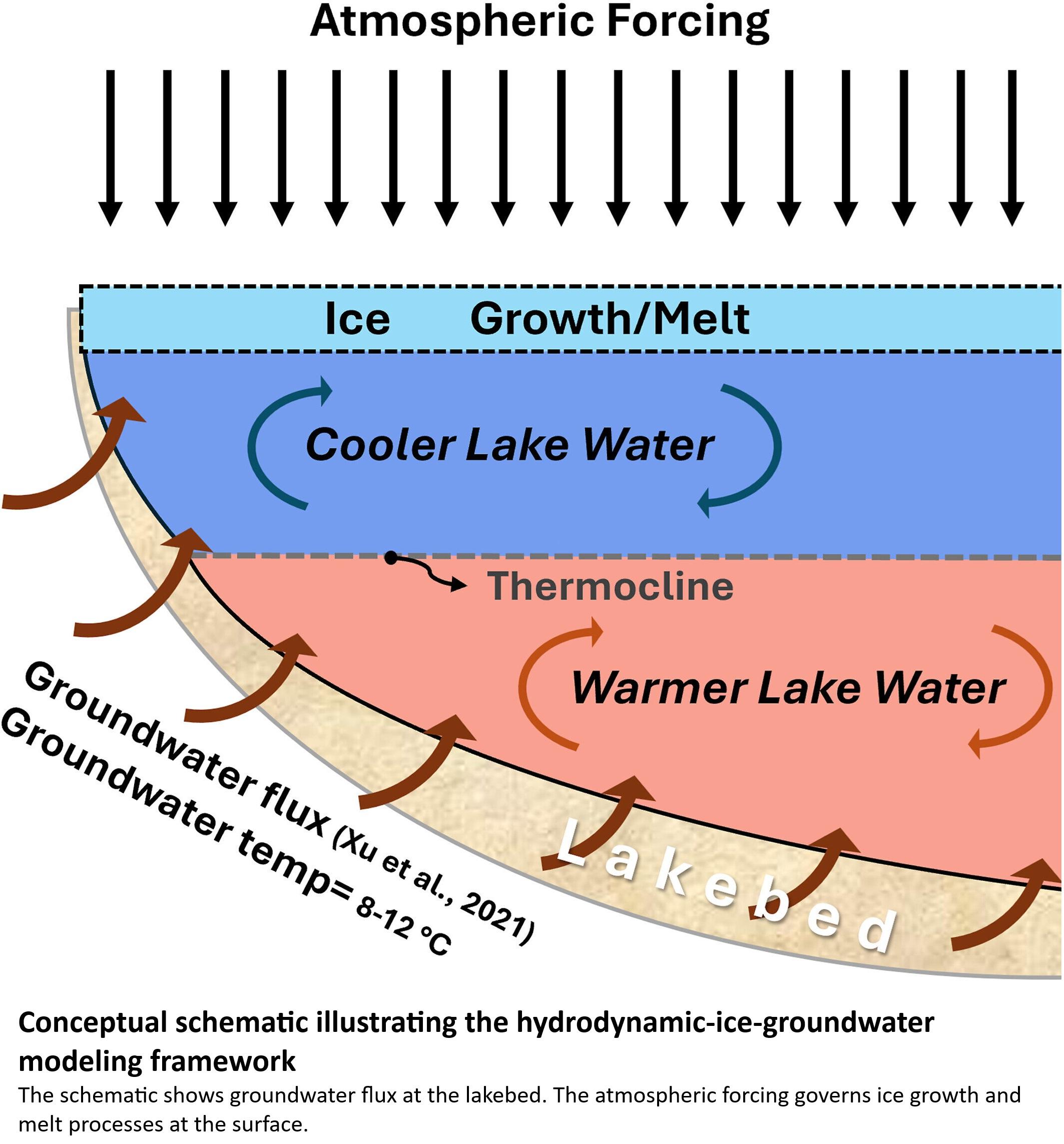
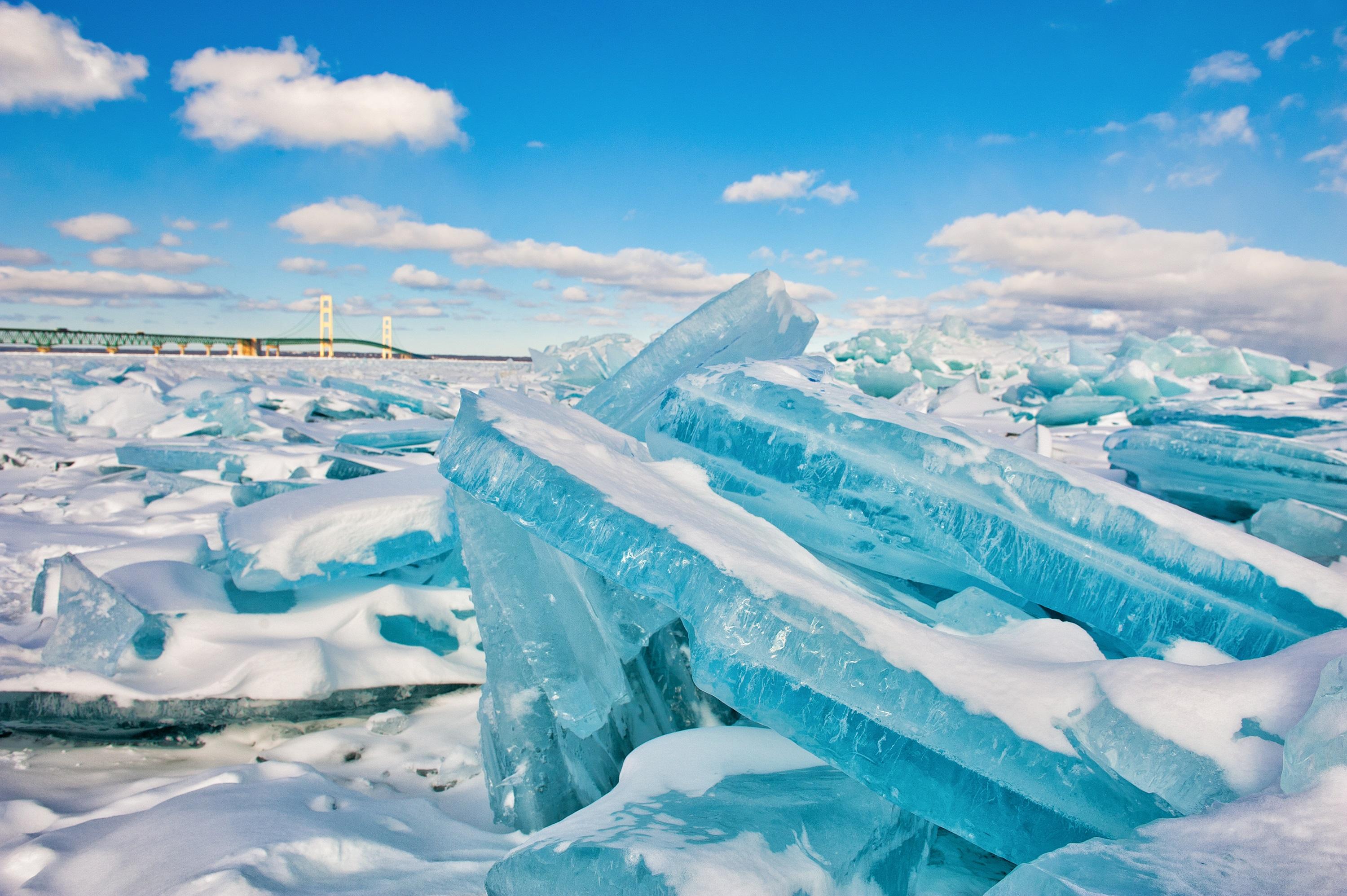
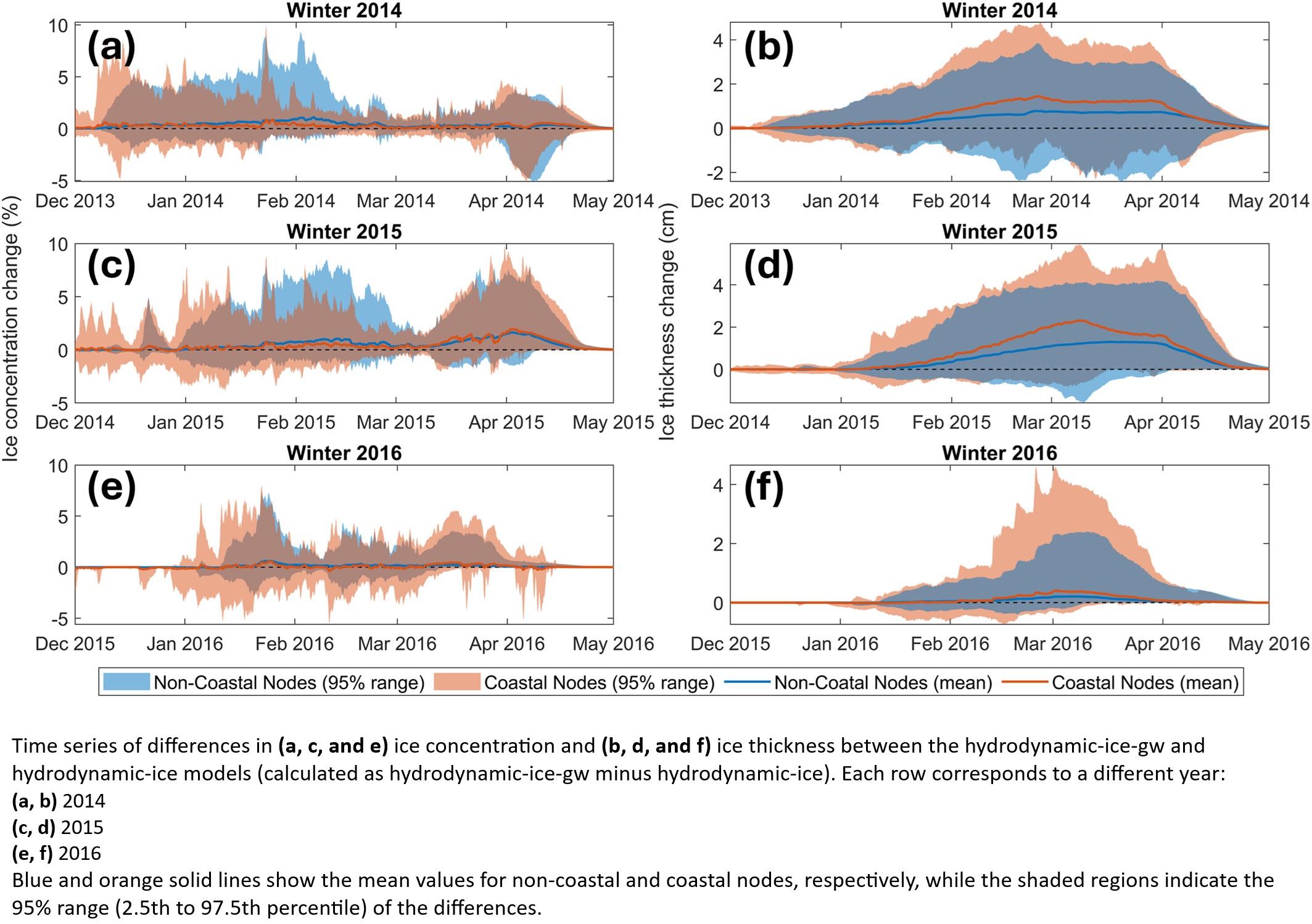
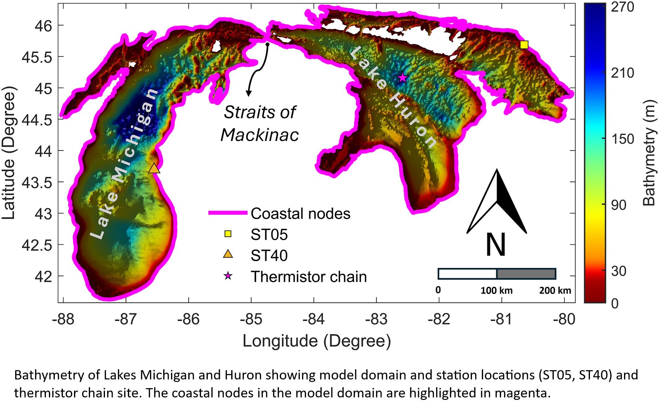
Intense Groundwater Flow Destabilizes Ice In North America's Great Lakes, Simulations Show
--
https://phys.org/news/2025-09-intense-groundwater-destabilizes-ice-north.html <-- shared technical article
--
https://doi.org/10.1029/2025WR040581 <-- shared paper
--
"KEY POINTS:
• Groundwater inflow enhances winter lake ice thickness by stabilizing the water column and reducing vertical mixing
• Ice responses to groundwater are strongest in coastal zones due to higher flux and shallow bathymetry
• Including groundwater in coupled models improves understanding of ice formation and winter lake processes…”
#water #hydrology #groundwater #flux #flow #GreatLakes #USA #LakeMichigan #LakeHuron #ice #climatechange #model #modeling #shoreline #coast #lakeice #melt #hydrodynamic #spatialanalysis #spatiotemporal #thermal #stratification #winter #bathymetry #coupledmodels #processes
Still on my #Bathymetry bullshit. In my ocean currents #Blender scene I'm using #Nasa bathymetry data and #GeometryNodes to drive the elevation of the earth model. Because the earth is essentially a very smooth sphere I have to greatly exaggerate the depth, with a non-linear gradient between the underwater regions and the coastal shelf. I was doing it with a Float Curve node, but I wanted to be able to easily tweak the parameters of where the points on the curve were.
Annoyingly there's no access to the points in a float curve, as node inputs or even with a #python data path that I could script. So I rigged up this node group to mimic the action of the float curve. I use a couple of Map Range nodes for each part of the line and switch between their output. It works well for a linear curve, I'm going to have to investigate whether the smooth interpolation in the Map Range node will let me achieve the same results as a float curve, and maybe automate it a bit.
#b3d #ScientificIllustration


Combining physical and artificial intelligence models to improve satellite-derived bathymetric (SDB) mapping in shallow areas compared to conventional methods #bathymetry
https://www.sciencedirect.com/science/article/pii/S1574954125003371

Mid-June we spent 2 days on a #Fieldtrip to the #Maade #River in #Wilhelmshaven as part of our #METAscales project
Day 1: Installed two new #SEBA gauges to track water level & conductivity—crucial in our sluice-and-pumping-station-drained catchment. 🔧 🌊 🛠️
Day 2: Gained hands-on experience with our boats & ADCP for bathymetry surveys. 🚤💧🔍
Learn more about METAscales https://lnk.tu-bs.de/MBdwv8
#BMBF #Equipment #Drainage #Bathymetry”

The seafloor around the remote British Overseas Territory of #AscensionIsland just got mapped, some of it for the first time ever...Looking at this cheerful looking crew in shorts , I wonder what it would be like to be one of the Ascension Island Government Conservation Team. https://gogeomatics.ca/seeing-what-lies-beneath-seafloor-mapping-in-a-marine-protected-area/ #bathymetry #marineReserve
European Geological Open Data (Map And Data) From The European Geological Data Infrastructure (EGDI)
--
https://www.europe-geology.eu/data-tools/map-viewer/ <-- shared link to map viewer
--
#geology #geosciences #earthsciences #data #spatialdata #criticalminerals #mining #geothermal #netzero #groundwater #carboncapture #ccs #GIS #spatial #mapping #opendata #webmapping #mapportal #Europe #EGDI #framework #GSEU #resources #naturalresources #opendata #water #naturalresources #geomorphology #bathymetry #geophysics #topobathy #remotesensing #earthobservation #waterresources


Surfing bathymetry refers to the underwater topography that shapes how waves break, including reefs, sandbars, and underwater canyons. The ideal bathymetry funnels wave energy toward shallow areas in a way that creates clean, rideable waves.
Thanks for sharing, Olivia S.!
#science #sciencefacts #bathymetry #surfing #surfingbathymetry
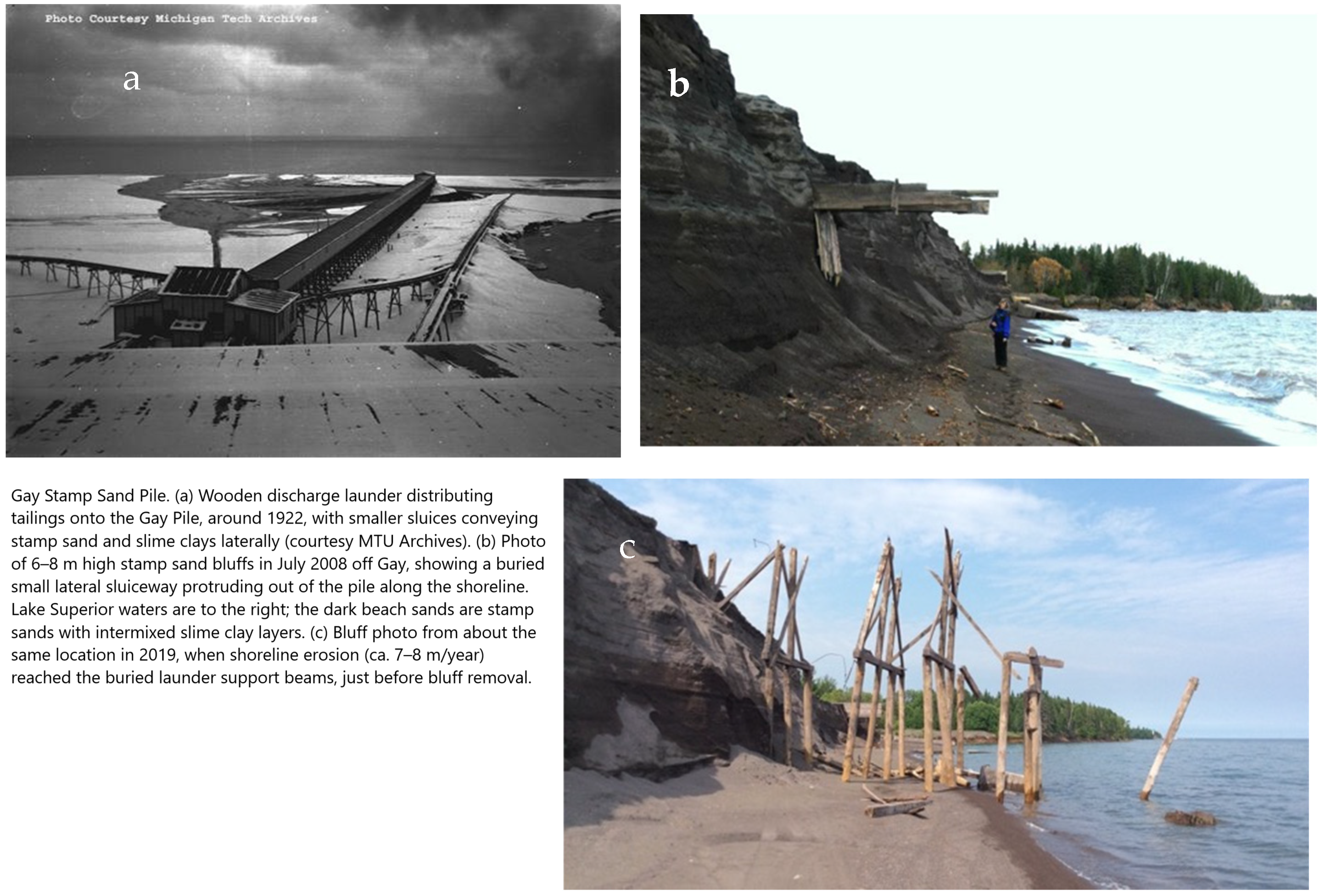
Coastal Environments - LiDAR Mapping of Copper Tailings Impacts, Particle Retention of Copper, Leaching, and Toxicity
--
https://doi.org/10.3390/rs17050922 <-- shared paper
--
#GIS #spatial #mapping #remotesensing #earthobservation #coastalenvironment #coast #coastal #mine #tailings #minetailings #GlobalTailingsManagementStandard #Keweenaw #LiDAR #bathymetry #topobathy #UAS #drone #particledispersal #copper #retention #leaching #BuffaloReef #toxicity #Daphnia #benthic #organisms #risk #hazard #contamination #impacts #sediment #water #hydrology #Michigan #USA #LakeSuperior #PortageLakeVolcanic #geology #spatialanalysis #biology #ecosystems #fisheries #trout #enviornmentalimpacts #leaching #riparian #systems
![aerial images - UAS high-resolution drone elevation and bathymetry surveys (base map 9 August 2022) of shoreline retreat at the original Gay pile location after bluff removal. Overlays along the beach edge trace shorelines in 2009, 2016, and 2022. The 78 m retreat over 6 years (2016–2022); equates to a 13 m/yr rate. The previous, nearly constant, long-term retreat rate prior to 2009 averaged 7.9 m/yr (ca. 26′) [7,57]. The original Jacobsville Sandstone shoreline, before stamp sands were discharged, is marked by the red border in the far-left upper region. Note white concrete basements of the two mills and remnants of both wooden and broken concrete launders in the northern region. Environmental recovery is beginning, as benthic organisms and fish are returning to clear underwater stretches of the bedrock shelf, where waves have removed stamp sands. Scattered trees (many birch) are beginning to colonise what is left of the original Gay Pile surface.](https://files.mastodon.social/cache/media_attachments/files/114/181/087/718/405/194/original/065f79c8b29e2466.png)
New Map Of Landscape Beneath Antarctica Unveiled
--
https://phys.org/news/2025-03-landscape-beneath-antarctica-unveiled.html <-- shared technical article
--
https://doi.org/10.1038/s41597-025-04672-y <-- shared paper
--
#GIS #spatial #mapping #Bedmap3 #icebed #surface #thickness #gridded #datasets #Antarctica #raster #model #modeling #landscape #elevation #icesheet #survey #remotesensing #earthobservation #climatechange #warming #climate #melt #melting #seafloor #subglacial #geophysical #survey #topography #geology #bathymetry #topobathy #BritishAntarcticSurvey
@BritishAntarcticSurvey


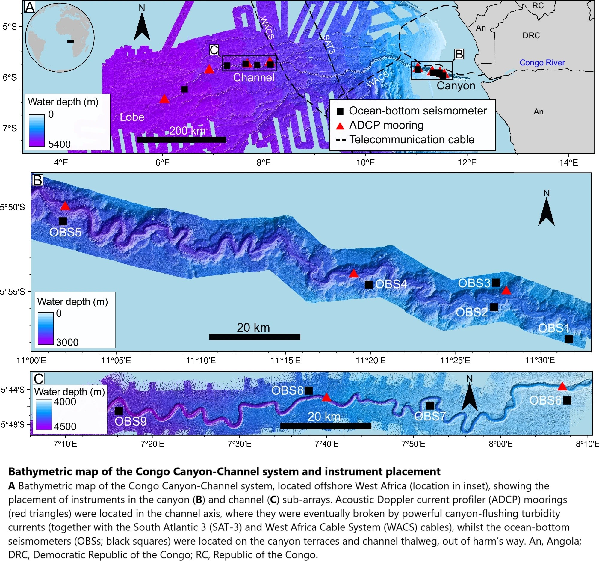
Seismometers Reveal Earth's Longest-Runout Undersea Sediment Flows In Unprecedented Detail
--
https://phys.org/news/2025-02-seismometers-reveal-earth-longest-runout.html <-- shared technical article
--
https://doi.org/10.1038/s43247-025-02137-z <-- shared paper
--
https://doi.org/10.1016/j.geomorph.2024.109350 <-- shared paper
--
https://doi.org/10.1038/s41561-022-01017-x <-- shared paper
--
#GIS #spatial #mapping #remotesensing #Congo #CongoChannel #bathymetry #seismometers #monitoring #sediment #flow #submarine #massmovement #canyon #infrastructure #pipes #cables #engineeringgeology #geology #model #current #debrisflow #bathymetric #Africa #offshore #coast #coastal #river #WestAfrica #instrumentation #acoustic #doppler #moorings #turbidity #thalweg #morphology #landslides #stratigraphy #seismic #turbiditycurrent #flow #gradient #slope #erosion #risk #hazard #spatialanalysis #spatiotemporal #seabed


Data Request For Potomac River Tragedy - National Centers For Environmental Information (NCEI), NOAA In The News
--
https://www.ncei.noaa.gov/ <-- shared NCEI home page
--
“A CNN Reporter requested data to portray the depth of the Potomac River near the site of the tragic plane and helicopter crash. The Digital Elevation Model Bathymetry (DEM) Team responded with information on how to use NCEI’s high-resolution Continuously Updated Digital Elevation Models (CUDEMs) to generate a map of the Potomac River and provided an example map…”
#GIS #spatial #mapping #remotesensing #bathymetry #topobathy #DEM #elevation #depth #NCEI #opendata #CUDEM #disaster #collision #air #potomacriver #potomac #crash #airdisaster #Washington #helicopter #ArmyHelicopter #blackhawk #NOAA #aviation #midair
@NOAA @NCEI
Client Info
Server: https://mastodon.social
Version: 2025.07
Repository: https://github.com/cyevgeniy/lmst