Rony Nedkov

Geospatial software engineer | Anything related to coding and GIS & Remote sensing excites me | Outdoor sports | Mountaineering

blog: oneprojectatatime.nl
developing: mapstyler.com

2025-06-19

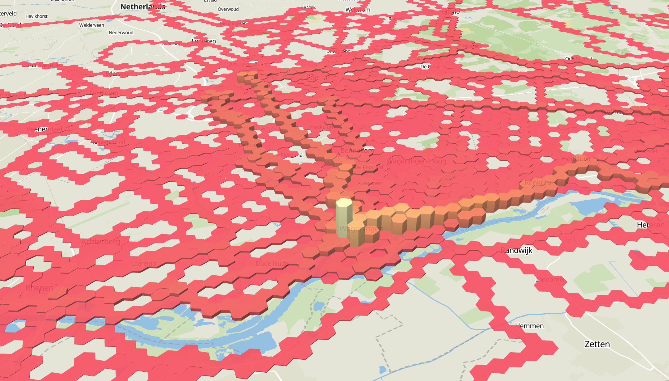
The exploring continues, decided to plot the with #maplibre using #pmtiles and some extrusion based on the unique activity count per hexagon.

Pretty awesome. Finding the right color palette is difficult though. Anyone any online resources with some background info about that?

#gischat

3D extruded choropleth map of strava activities using hexagons
2025-06-19

Looks a bit like all streets

benfry.com/allstreets/

2025-06-18

Plotted 4.5 million points of my Strava activity in a specific country.

Without any contextual information, I guess it's not that hard to guess the country?

#gischat

2025-06-08

@oshistory Impressive collection and very interesting to go through it.

Have you seen what the Dutch have done with their old maps? You can travel through time

topotijdreis.nl/

Rony Nedkov boosted:
Lokjo - a European online maplokjo@mapstodon.space
2025-06-08

UPDATE 2: We're carefully back online again, with a few exceptions:

mapstodon.space/@lokjo/1146578

Can we have a lill boost please? The fediverse is the only place we're on.

We're a replacement for googlemaps.

European, non-commercial, pro-local.

lokjo.com

Thanks for sharing 😊

#golocal #maps #EU

2025-06-07

Recently, I got back into my electronics projects. While working with a colleague on a IoT project, he asked me how I know which development board to choose.

At first I thought I had no idea, but I found out I did. So I decided to jot down my train of thoughts

oneprojectatatime.nl/how-to-ch

#esp32 #raspberrypi #iot

2024-07-18

@kate the offcial website says it's being updated every year.

2024-07-18

Oke, a closure look revealed that not all trees are included, but still.

2024-07-18

@rduivenvoorde

Yes, it is. It's part of the 'Basisregistratie Topografie

See pdok.nl/introductie/-/article/ for more information and options to get the data.

You can also use the download viewer: app.pdok.nl/brt/top10nl/downlo. Draw a polygon of your area of interest and hit download.

The .zip contains a bunch of gml's. I found the trees in the 'inrichtingselementen.gml' as point featuers. A filter on "typeInrichtingselement" = 'boom'.

2024-07-18

@RagnaJa Yes,

There are different ways to access the data. The easiest and quickest is via this download viewer: app.pdok.nl/brt/top10nl/downlo.

Just draw a polygon of your area of interest and hit the download button.

I found the trees in the 'inrichtingselementen.gml' as point featuers. A filter on "typeInrichtingselement" = 'boom'.

2024-07-17

It fascinates me every time I see it. The Dutch government has an official geodataset which includes all trees in the country.

-- edit: not all, but a lot

2024-05-24

Here is an update on what I'm working on. #buildinpublic

I'm exploring auto styling #OGC Vectortiles in #mapstyler. In this example, the population density is styled based on a user defined color. Very happy with these first results.

I'm just not sure about the map readability of this implementation. The coloring scheme is of course dependent on the distribution of the data. So I guess additional options for categorization of the data are needed.

#gischat #indiedev #gis #webgis

Rony Nedkov boosted:
2024-05-01

I'm giving #Tilemaker (tilemaker.org) a go to generate me some #VectorTiles from #OpenStreetMap πŸ—ΊοΈ

Lovely little self-contained project 😍 It's able to generate #Protomaps .pmtiles to visualize with #Maplibre πŸ‘

Getting started is as easy as

docker run -it --rm ghcr.io/systemed/tilemaker:master --help

Solid work there @richardf πŸ™Œ

tilemaker website header
2024-03-01

A new version of mapstyler.com is available! New features are amongst other:

- Applying data filters
- Styling based on data filters
- Beta support for OGC Vector Tiles

Read more about the new release in this blogpost

oneprojectatatime.nl/new-relea

#gischat #openlayers #mapstyler #geo

2024-03-01

@jcarlson win 11. I used snipping tool, but it gives an error and my attempts to fix it have failed.

2024-03-01

I need a screen recorder to record demo videos of apps. Any ideas?

2024-02-27

Musical #osm. Live map playing sounds and showing edits on openstreetmap. Quite relaxing. #gischat

musical-osm.netlify.app/#

2024-02-23

Scrape esri rest API to geojson

github.com/openaddresses/pyesr

2024-02-23

@markstos Took me some time, but I finally got the chance to dive into scratch layers in QGIS. It indeed works really nice and promising.

Client Info

Server: https://mastodon.social
Version: 2025.04
Repository: https://github.com/cyevgeniy/lmst