
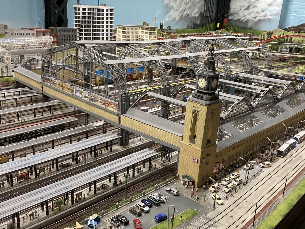
@mfuhrmann Hm? Erst mal die Gebäude; auch den Übergang. Dann #IndoorMapping der Stockwerke, Räume und Stützen. Gehen indoor da auch Tische? Die Regionen erst mal.
Weiter als #MicroMapping für die Geleise und Modellgebäude?! Da in #OpenStreetMap alles geht, geht auch alles in Miniatur. Was zeigen die 2D/3D Renderer da noch alles an? Terrain ist bei OSM ja noch mangelnd. Wie gehen in "echt" Tunnel und Berge? Selbst wenn 3D die height-tags berücksichtigt werden.
Die Standard- #VectorTiles reichen jedenfalls nicht. Aber man kann ja Zusätzliche parallel generieren.
Das #MiWuLa wäre eine Schweine-Arbeit! Wenn sie helfen, mit Plänen und Dateien, wird es 50% leichter. Hat schon mal jemand von #OSM mit denen gesprochen? Einfach mal fragen ...
Einige Teile sind ja 1:1 nach gebaut, also in OSM schon vorhanden. Könnte man kopieren.
Es gibt 3D Renderer, wo Autos fahren. Züge noch nicht, gell? Dafür FOSS-Bahn-Spiele. Und das dann in der VR-Brille - wild zu einem virtuellen Rundgang. Träum ...
#VectorTiles

🚀 QGIS2VectorTiles v1.2 is out!
✅ Full support for #QGIS data-defined properties (symbols and labels)
✅ Improved centroid label generation (choose whether labels are based on the whole polygon or only the visible part)
⏩ Next step ➔ Generating #MapLibre sprites 🔥
#VectorTiles #GIS #FOSS #Geospatial #GDAL #Cartography #wms #wmts

The main #VectorTiles tileset contains route information for more informative transportation map styles. A new tileset contains territories as polygons, so your custom map can color in a country or other administrative region.


🚀 Introducing QGIS2VectorTiles!
#QGIS plugin which turn your project into a lightweight #VectorTiles package for WMS/WMTS serving or easy sharing.
✅ Converts all vector sources to a single .mbtiles/XYZ using #GDAL.
✅ Preserves rich styling (renderers, labeling, expressions etc).
✅ Generates a .qlr for easy sharing.
⏩ Generates a client-side #MapLibre styling (In Dev).
Thanks to @underdarkGIS @nyalld @EvenRouault & all #FOSS #GIS community that made this possible!

Inzwischen liegt der Mapbender in der Version 4.2.4 vor 📣 und es gibt diverse Neuerungen - Routing mit Export, sekundengenaue Aktualisierung für WMS-Dienste, Filter im Ebenenbaum, Vector Tiles u.v.m..
Einen tiefen Einblick in alle Details bietet der ausführliche Blogartikel unserer Kollegin @Astrid Emde aus dem Mapbender-Team – jetzt reinklicken 👇
https://wheregroup.com/blog/details/mapbender-4-neuerungen-und-praxisbeispiele/


Die @foss_academy Termine 2026 für unsere Web-Seminare sind Online.
Wir bieten jeweils am 1. Donnerstag im Monat ein kostenloses einstündiges Web-Seminar an.
👉 10.00 - 11.00 Uhr
Es geht um #MapServer #WMS Time #PostGIS #PostgreSQL #QGIS #Python #Mapbender #GeoServer #VectorTiles #OGC API #MapComponents & mehr
Jetzt schon anmelden!
👉 https://foss-academy.com/web-seminare/
#FOSSGIS #OSGeo #GIS #GEOSPATIAL #FOSS4G #WebGIS


#30DayMapChallenge – Day 13: 10 minute map Map of the #Mara River Basin made in #QGIS with #HydroSHEDS #opendata and @maptiler.bsky.social #vectortiles. 🎥 Try it for your own catchment: youtu.be/hUgEYKz87gw


#30DayMapChallenge – Day 13: 10 minute map
Map of the #Mara River Basin made in #QGIS with #HydroSHEDS #opendata and @maptiler.bsky.social #vectortiles.
🎥 Try it for your own catchment: https://youtu.be/hUgEYKz87gw

#30DayMapChallenge day 2: Lines 🗺️ Mapped Rotterdam’s watery past through street names with pre- and suffixes like singel, boezem, sloot, vaart, haven, and gedempte. These names trace water infrastructure. Some still flowing, others filled in.
Made with #qgis #openstreetmap and #maptiler #vectortiles
#toponymes #gis #mapping

#30DayMapChallenge 2025 day 1: points
Inspired by my stay in Maastricht performing Carl Orff's #CarminaBurana with Brabant Koor & the Jussen Brothers.
Today’s map shows Dutch place names ending in -tricht, -drecht, -trecht—derived from Latin Trajectum, meaning river crossing. #toponyms
Maastricht = Mosa Trajectum.
Made with #QGIS #OpenStreetMap and #vectortiles from @maptiler.bsky.social
🎟️ Still tickets for the amazing concerts weekend: https://jussenmaastricht.nl/


Someone commented on my feedback form tjat "footpaths on low zooms are still missing". I think that is a feature for a more specialized map.
I think it is possible to use script to configure the map, like for outdoor/hiking/biking etc, by manipulating the styles - for example display footpaths in lower zoom levels than now, and possible style them to be more visible.
If you have ideas, using that form - linked in the map's about dialog - or even here is fine. I'm looking at displaying national parks and some other protected areas based om a comment here, for example.
Thank you for inspiration :)

A Leaflet Developer’s Guide to High-Performance Map Visualizations in React

#VectorTiles coming to DuckDB: #DuckDB’s #spatial extension is about to support #Mapbox Vector Tiles (#MVT) with the newly merged ST_AsMVT and ST_AsMVTGeom functions. The two new functions are scheduled to be shipped next week in DuckDB version 1.4.
https://spatialists.ch/posts/2025/09/10-vector-tiles-coming-to-duckdb/ #GIS #GISchat #geospatial #SwissGIS

Ah yes, the classic tale of reinventing the wheel but in #Go 🛠️, because who doesn't want to spend their weekend building vector tiles from scratch when there are a bazillion libraries already out there? 🤔 Next up: How to build a toaster using only a rock and a stick, because why not! 🍞🔥
https://www.debuisne.com/writing/geo-tiles/ #reinventingthewheel #vectorTiles #programming #humor #weekendProjects #HackerNews #ngated
Free #Openstreetmap #vectortiles is really going wow: first https://openfreemap.org/ than https://maps.black/ and now officially on OSM. #OSM
Kommen Sie zu uns nach Berlin!
Im September 2025 laden wir Sie zur 2-tägigen Schulung der @foss_academy zum Thema
👉 Einführung in Vector Tiles
nach Berlin ein.
15.-16. September 2025
Erzeugen Sie #VectorTiles mit #QGIS & der t-rex Software. Lernen Sie dazu noch #MapLibre & #Maputnik & @MapComponents kennen.
https://foss-academy.com/schulungen/einfuehrung-in-vector-tiles/
#FOSSGIS #WebGIS #GDI #GEOSPATIAL #OSGeo #FOSS4G @WhereGroup_com #GIS

Verden er fuld af underlige væsener / the world is full of strange beings.
Custom style derived from osm bright by openmaptiler.org, tiles from openfreemap.
#osm #openstreetmap #openfreemap #maptilers #VectorTiles #maplibre


[…] 2/2
🏙️ Ciddle: Städte raten wie bei Wordle
📋 Opengist: Gist-Dienst zum Selbst-Hosten
🗺️ Bikerouter-Update: der aktuelle Stand des Build-Prozess-Umbaus
🔊 In dieser Woche gehört: Mona Moore, Intaktogene, Tobias Sommer, Matchy, Julep|z
#Wochenrückblick #Vermessung #Kataster #OpenStreetMap #VectorTiles #Wikimap #Wikipedia #Glühlampe #H7 #Ciddle #Wordle #Opengist #Gist #Gitea #Bikerouter #GravelOverlay #Techno
Wochenrückblick, Ausgabe 102 (2025-30)
Themen:
🧭 Einmal Garage vermessen: 677 Euro 🫰
🗺️ OpenStreetMap Vector Tiles: Es ist noch ein weiter Weg.
🌍 Wikimap: Geolokalisierte Wikipedia-Artikel auf einer Karte – ein schlimmer Zeitdieb.
💡 Beide H7-Lampen im Auto innerhalb von vier Wochen defekt.
[…] 1/2
#Wochenrückblick #Vermessung #Kataster #OpenStreetMap #VectorTiles #Wikimap #Wikipedia #H7 #Ciddle #Wordle #Opengist #Gist #Gitea #Bikerouter #GravelOverlay #Techno

With the #OpenStreetMap website’s new #VectorTiles, it’s nice to see that we can zoom in to level 23! Unfortunately, if the vector coordinates are not stored with OSM’s 7 decimal places for higher-zoom tiles, then what’s the point of all that zoom? 👀
