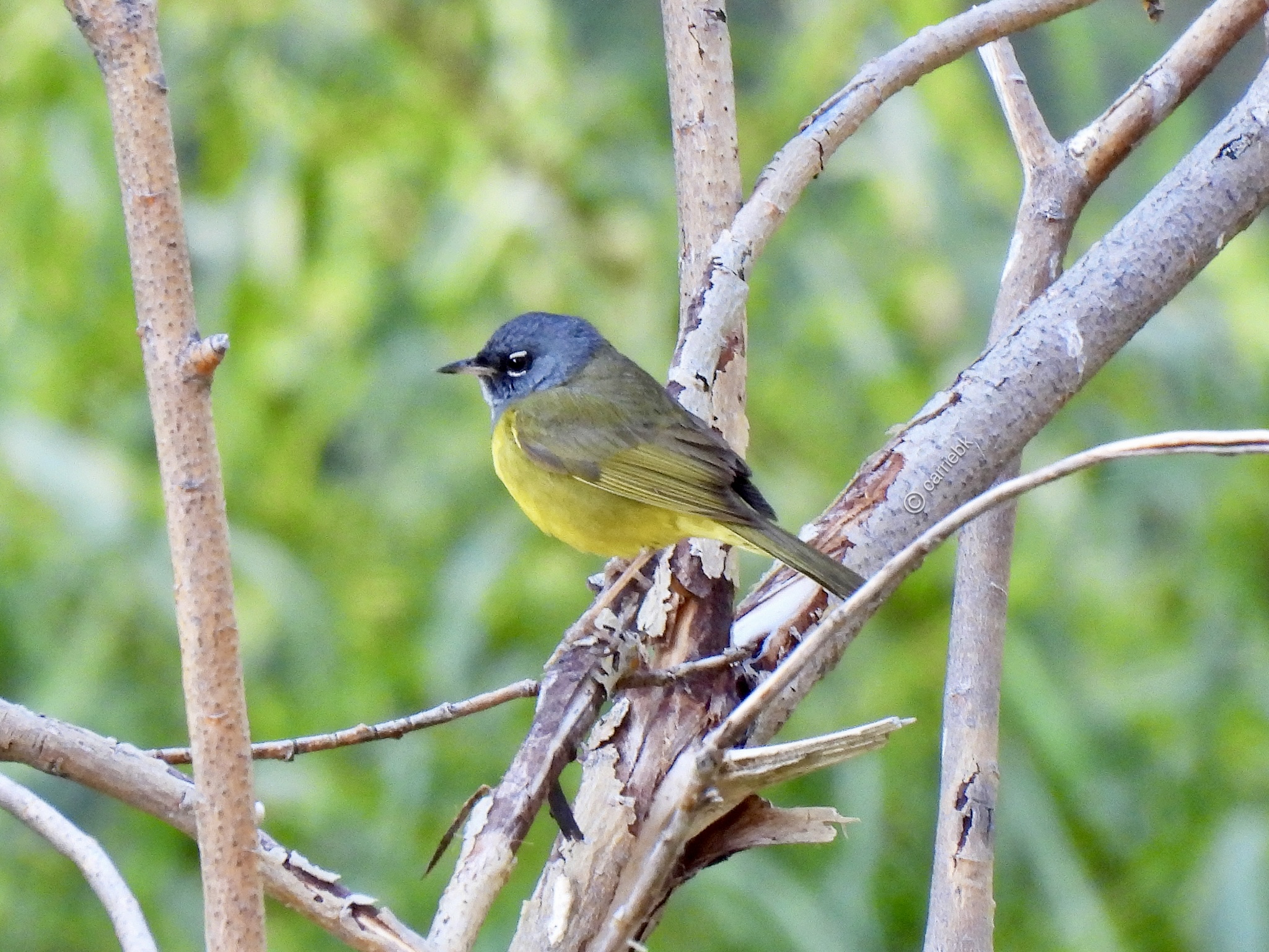
MacGillivray's warbler
#macgillivrayswarbler #warbler #naturephotography #nature #birds #birders #birdwatchers #birding #birdwatching #birdphotography #angelesnationalforest #angelesNF #sangabrielmountains #dailybird #birdsofpixelfed #birdsofmastodon #naturephotos #LAwildlife #losangeles
#AngelesNF
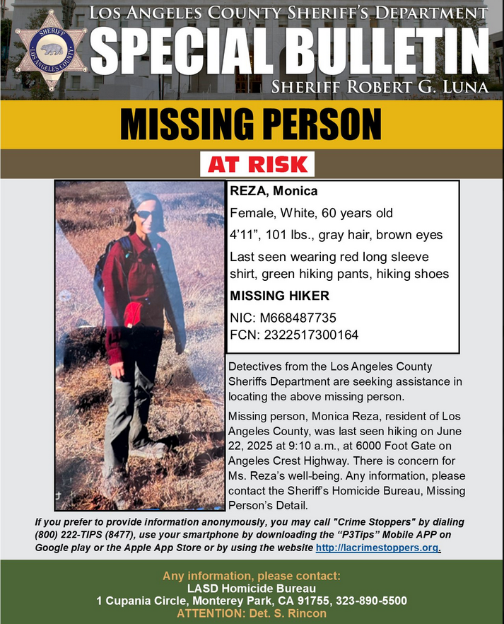
Hmm, if someone has 3m/px PlanetScope access, could be helpful for that missing woman near Mt. Waterman, California. (I don't have real time access, only archive access) #remoteimaging #gis #SearchAndRescue #SAR #AngelesNF
From Montrose SAR (earlier this morning)
Montrose Search & Rescue Team (Ca.)
"Day 6 – The search for Monica Reza continues in the Mount Waterman area. SAR teams from San Diego to Tulare County have joined the mission to help bring her home. We’re grateful for their tireless efforts. #FindMonicaReza #MontroseSAR #MutualAid
"Please avoid the search area. Uncoordinated hikers can interfere with tracking, delay progress, or create new emergencies. We also have enough food & supplies at this time. Thank you for supporting trained teams. #StayClearForSafety #SAR #AngelesNationalForest"
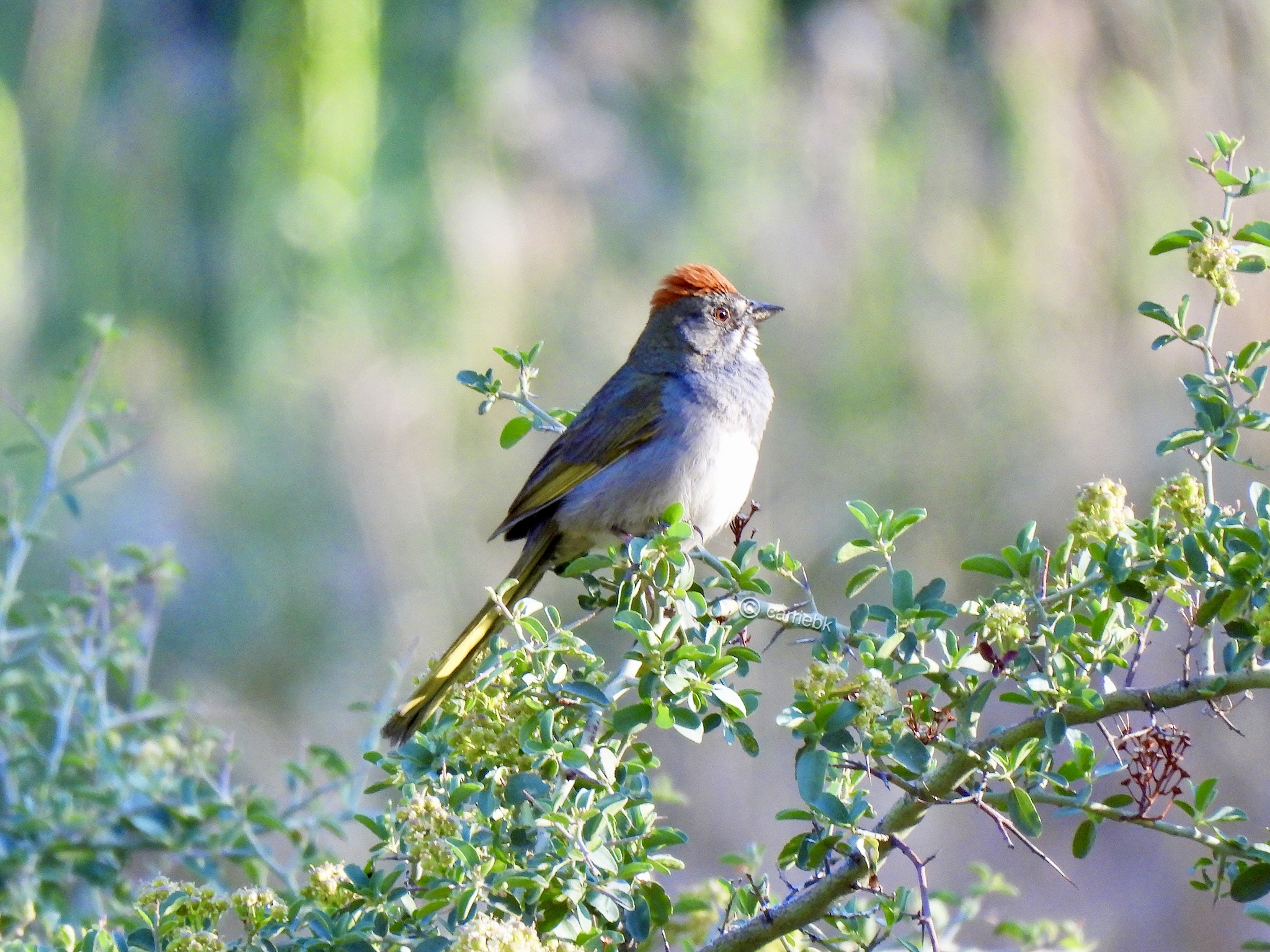
Green-tailed Towhee
#greentailedtowhee #towhee #naturephotography #nature #birds #birders #birdwatchers #birding #birdwatching #birdphotography #angelesnationalforest #angelesNF #sangabrielmountains #dailybird #birdsofpixelfed #birdsofmastodon #naturephotos #LAwildlife #losangeles
#greentailedtowhee #towhee #naturephotography #nature #birds #birders #birdwatchers #birding #birdwatching #birdphotography #angelesnationalforest #angelesNF #sangabrielmountains #dailybird #birdsofpixelfed #birdsofmastodon #naturephotos #LAwildlife #losangeles
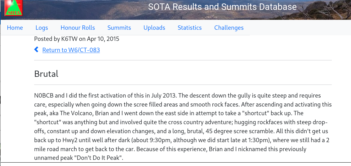
Nearby ham radio peak here, which tells you how rough the terrain is.... These two hams nearly got lost/in trouble. (took them ***NINE HOURS*** to get back to their car from the peak)
""Don't Do It Peak"
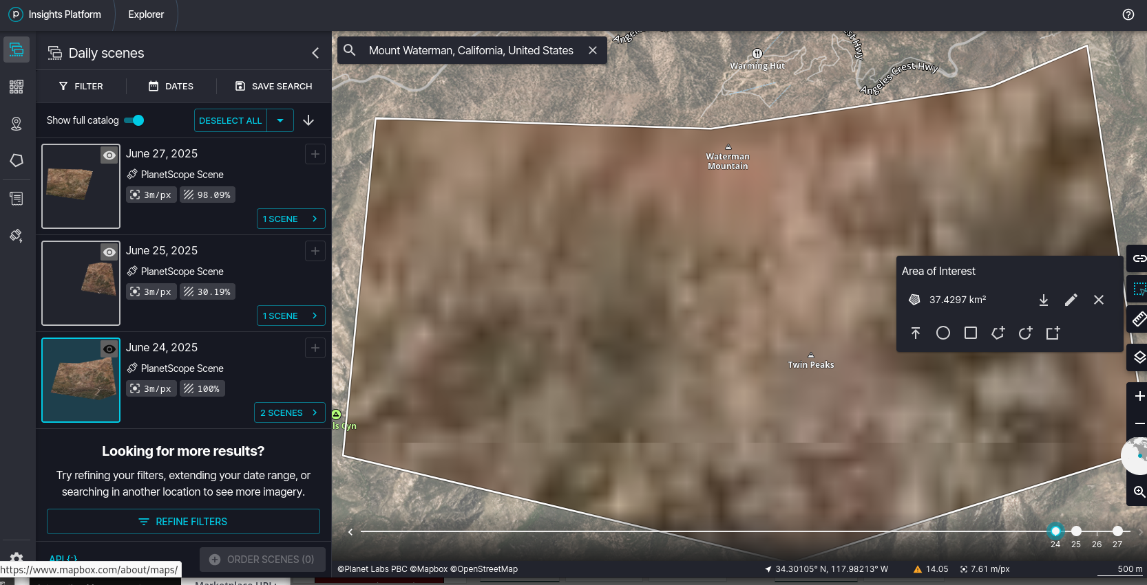
No current imagery of the area that person is in. $759 for new imagery, but the time will be 2-3 days (or longer) to acquire, which is not great when you've been missing for 3 days. That said, there is water at the bottom of the canyon, you won't starve to death as long as you stay hydrated and don't hurt yourself. You might locate someone if they are smart enough to be out in the open with reflective/bright colors. (ps. tip: BRING AN EMERGENCY BLANKET WITH YOU HIKING ALL THE TIME... Can't miss it from a helicopter) #SearchAndRescue #SAR #hiking #Waterman #AngelesNF
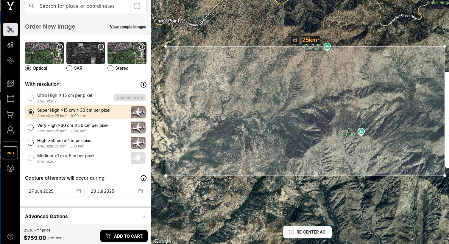
Ooh, satellite imaging 99cm resolution available from 11:26 AM that day, plus some of that area the next day. Dunno if it will be useful, but fine, I'll make a donation to the cause and order up the images to see if they are useful. Only the equivalent cost of 14 days of Starbucks Apple Crisp Macchiato (Grande) #SearchAndRescue #SAR #AngelesNF #GaryRobertNuetzel
That is one of the busiest trails in the Angeles... you have get up there before 9am to get a parking spot. It's CRAZY busy. So... wonder which direction he went. Hoegee's trail camp there. #ChantryFlat #MissingPerson #SAR #SearchAndRescue #AngelesNF
Hmm, missed this, I guess I should pull up some satellite photos. The main issue here is most of the trail is under cover. #MissingPerson #SearchAndRescue #SAR #ChantryFlats #AngelesNF https://ktla.com/news/local-news/man-80-missing-for-weeks-after-going-hiking-in-southern-california/
Tanbark Prescribed Fire
"The Tanbark Prescribed Fire is planned for Monday, June 10, through Wednesday, June 12, provided conditions allow, in the mountains above the foothill communities of Glendora, San Dimas, and La Verne, CA. Smoke could be visible through June 16, as prescribed fire operations may continue for several days, if conditions allow, in order to complete planned acreage."
#AngelesNF #wildfires #CAwx #USFS https://www.fs.usda.gov/alerts/angeles/alerts-notices/?aid=87999
USFS: Fire Danger Increases to ‘MODERATE’ at the Angeles National Forest
Effective immediately, fire danger levels have increased to MODERATE at the Angeles National Forest, which includes the San Gabriel Mountains National Monument. Visitors to the Angeles National Forest, including recreational cabin owners and concessioners, are advised of the following updates:
https://www.fs.usda.gov/alerts/angeles/alerts-notices/?aid=87870
NBC: Person dies after driving off cliff during police chase in Angeles National Forest #LosAngeles #pursuit #AngelesNF https://www.nbclosangeles.com/news/local/person-dies-after-driving-off-cliff-during-police-chase-in-angeles-national-forest/3220483/
Client Info
Server: https://mastodon.social
Version: 2025.04
Repository: https://github.com/cyevgeniy/lmst