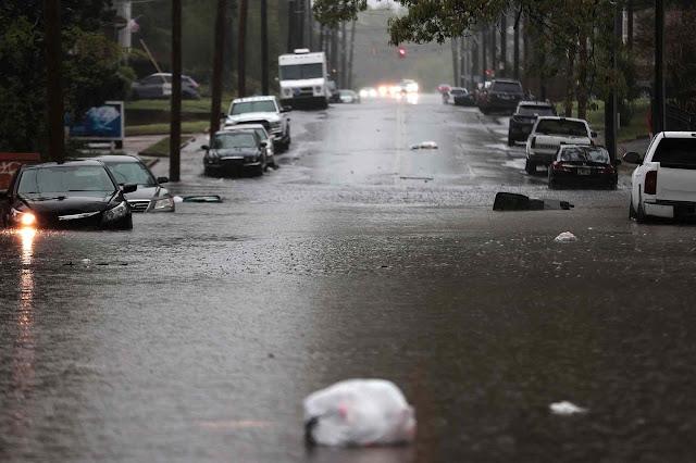
"...“This is something I’ve never seen in my life,” said Wheeling Police and Fire spokesman Philip Stahl told The Wheeling Intelligencer. “Multiple refrigerators, storage containers, even boats, were carried by the floodwaters.”..."
#FlashFlooding
📢 #Flashflooding last week in central #nigeria killed more than 150 people, a local disaster response spokesman told AFP on Saturday, while displacing 3,000, levelling more than 250 homes and washing away two bridges
#emergencyresponse
#disastermanagement
#africa
📰 Report: Ahram/AFP 👇🏽
Heads up: Severe storms and flash flooding possible today from the Ohio Valley to the Mid-Atlantic.
Expect hail, wind, and isolated tornadoes.
Meanwhile, big temperature swings: chilly in the North, intense heat in the South.
Flash flood risk grows this weekend in the Ozarks.
#SevereWeather #FlashFlooding #HeatRisk #WeatherAlert #WxMastodon #Meteorology
https://www.makensweather.com/weekly-weather-watch/2025/05/21/weekly-weather-watch
#Evacuations ordered after parts of #NSW received more than 260mm of rain.
#Emergency & watch & act #warnings remain in place for parts of the #NewSouthWales #Hunter & #MidNorthCoast regions, as #intenserainfall, #damagingwinds, & #flashflooding continue. #auspol #weather
Residents in parts of #Bulahdelah have been told to #evacuate their homes, as well as those in #Patterson, #Dungog & #Gloucester. A seek shelter warning is in place for #Taree.
https://www.abc.net.au/news/2025-05-20/weather-warnings-for-nsw-live-blog/105311220
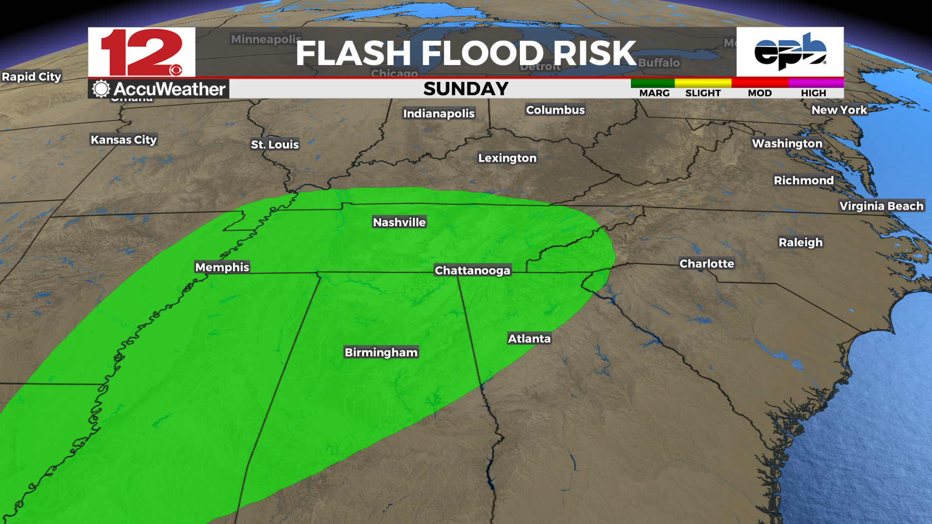
Waves of #rain & #thunderstorms are expected to continue over portions of the #South this week, with forecasters warning of #FlashFlooding alongside other threats that accompany severe weather, especially across #Texas, #Louisiana & #Mississippi. In Texas, a search-&-rescue effort recovered the body of a 10-year-old girl who was swept away by floodwaters on Monday.
#Trump #FEMA #NOAA #cuts #DOGE #Musk #ExtremeWeather #ClimateChange #NaturalDisasters #EmergencyAid
As #Trump makes drastic #cuts to #FEMA, a #Texas girl is swept away by #flood & the #South faces more #SevereStorms
Forecasters warn a slow-moving #storm system is expected to bring heavy #rain, #thunderstorms & #FlashFlooding from Texas to #Mississippi.
#NOAA #DOGE #Musk #ExtremeWeather #ClimateChange #NaturalDisasters #EmergencyAid
https://www.nytimes.com/2025/05/06/weather/texas-mississippi-storms-flooding.html?smid=nytcore-ios-share&referringSource=articleShare&sgrp=p&pvid=A7E0D17B-CCE0-4773-A0CA-7F9B54092107
Death Toll Rises to 16 Amid Severe Storms and Flooding in Central-Eastern United States https://www.rainsmediaradio.com/2025/04/death-toll-rises-to-16-amid-severe.html?utm_source=dlvr.it&utm_medium=mastodon Follow, Like & Share #SevereWeather #FlashFlooding #USStorms #EmergencyResponse #WeatherAlert
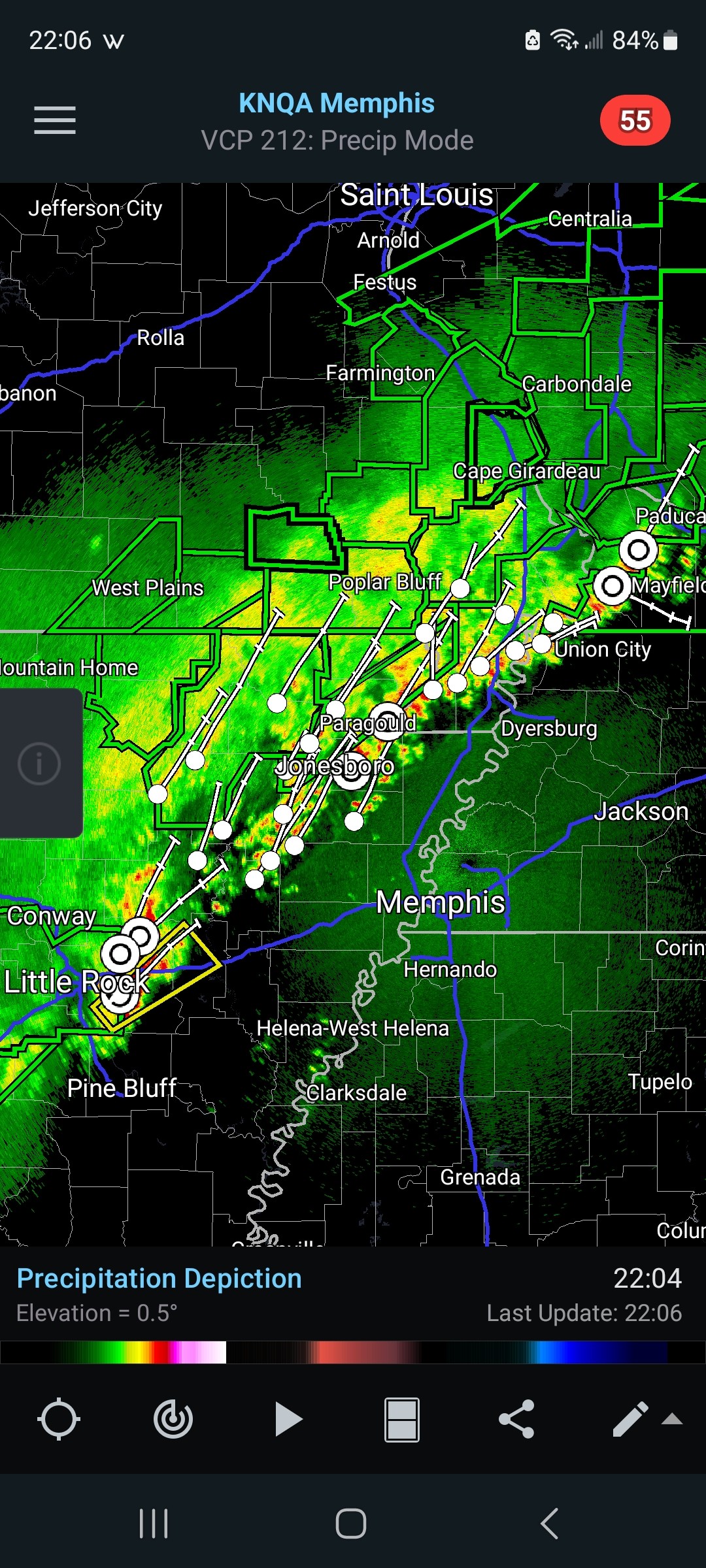
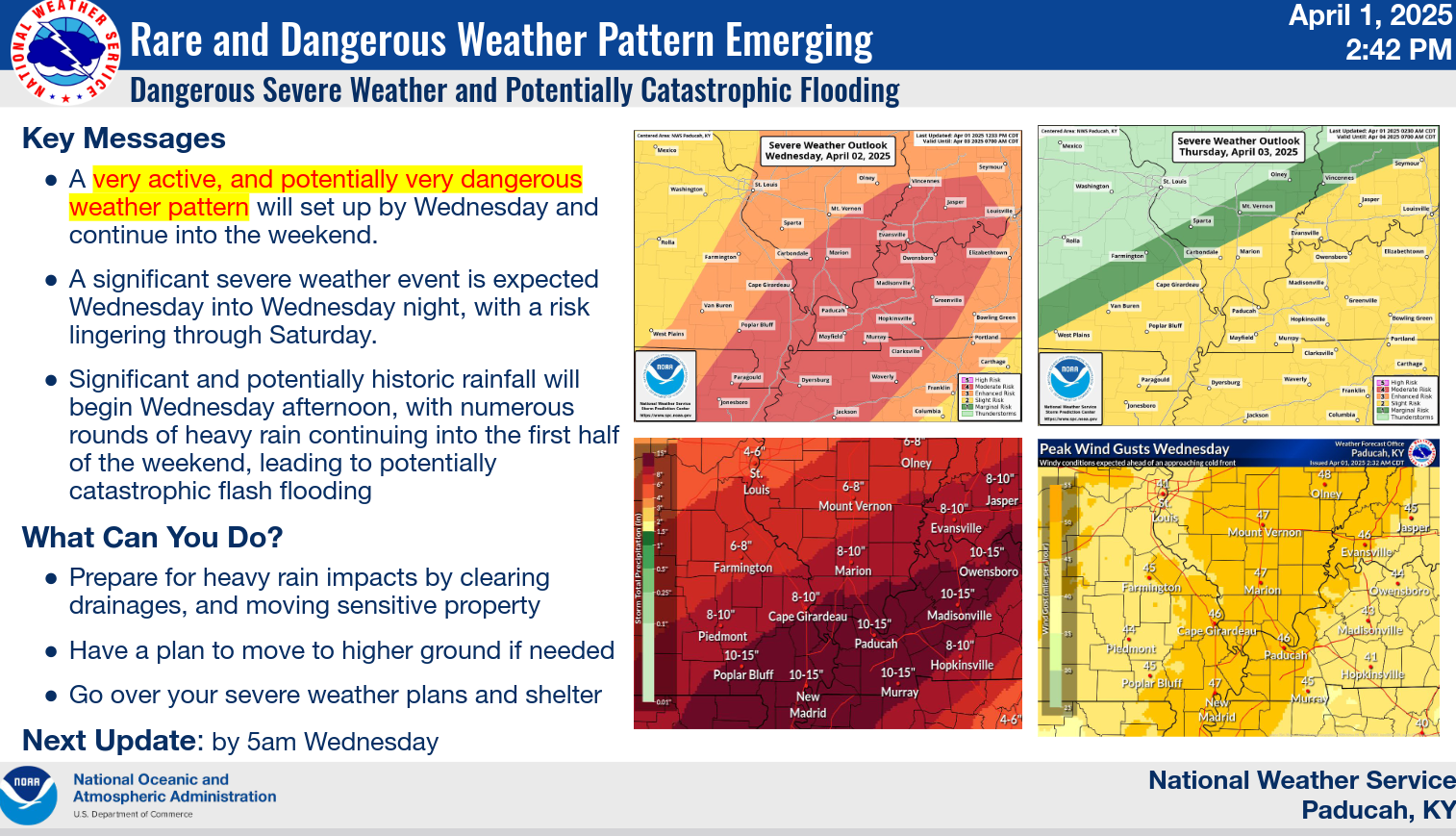
"Potentially catastrophic flooding could occur in the mid-South and Ohio Valley regions as multiple bouts of #ExtremeRainfall impact those regions into the weekend.
Rainfall totals could reach 10 inches or more in what some National Weather Service offices are calling a "particularly dangerous situation" that will produce life-threatening #FlashFlooding as well as major flooding that could approach record levels in some locations. "
"#ClimateChange is bringing heavier rainfall extremes and increased, inequitable flood risk to many parts of the U.S.
For every 1°F of warming, the air can hold 4% more moisture, increasing the chances of heavier downpours that contribute to #FlashFlooding hazards. "
https://www.climatecentral.org/climate-matters/heavier-rainfall-rates-in-us-cities
#ExtremeRain
Major extreme weather event incoming for the US.
Excessive Rainfall Discussion
NWS Weather Prediction Center College Park MD
339 AM EDT Wed Apr 2 2025
Day 1
Valid 12Z Wed Apr 02 2025 - 12Z Thu Apr 03 2025
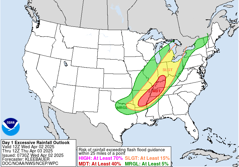
...THERE IS A MODERATE RISK OF EXCESSIVE RAINFALL FROM SOUTHERN ARKANSAS TO SOUTHERN INDIANA...
..A PROLONGED LIFE-THREATENING FLASH FLOOD EVENT WILL BEGIN TODAY
WITH SEVERAL DAYS OF HEAVY RAINFALL IMPACTING A LARGE PORTION OF THE LOWER MISSISSIPPI AND OHIO VALLEY'S..
(continued)
https://www.wpc.ncep.noaa.gov/qpf/ero.php?opt=curr&day=1
NWS:
"Significant and potentially historic rainfall will begin Wednesday afternoon, with numerous rounds of heavy rain continuing into the first half of the weekend, leading to potentially catastrophic flash flooding"
Risk rises for #mudslides around #LACounty fire zones; prepare for worst-case scenario, officials warn
Alene Tchekmedyian, Rong-Gong Lin II, Melody Gutierrez, LA Times
January 26, 2025
"With more rain on the way, officials warned Sunday of an increasing risk of mudslides in #LosAngelesCounty's burn areas, with a 10% to 20% chance of significant #FlashFlooding and #DebrisFlows capable of damaging roads and homes in and around areas devastated by #wildfires.
"'This is the worst-case scenario to prepare for,' said Kristan Lund, a meteorologist with the National Weather Service in Oxnard.
"'We do have increasing concern for the #BurnScars,' Lund said. The charred footprint of the Eaton fire, which blackened more than 14,000 acres, is the most worrisome. 'These #FlashFloods and these debris flows could happen in and near or below these burn scars.'
"A #FloodWatch took effect at 10 a.m. Sunday and was set to continue through 4 p.m. Monday for the burned areas of the #EatonFire in the #Altadena and #Pasadena areas; the #PalisadesFire and #FranklinFires in the Pacific Palisades and Malibu areas; the Hughes fire around Lake Castaic; and the Bridge fire in the San Gabriel Mountains west and southwest of Wrightwood. The flood watch started six hours earlier than originally anticipated as rain began falling steadily around Los Angeles."
Read more:
https://www.aol.com/news/risk-rises-mudslides-around-l-170323295.html
#ClimateCrisis #CaliforniaFires #BurnScar #FlashFloodWarning #FloodDanger #Mudslides #CaliforniaWx
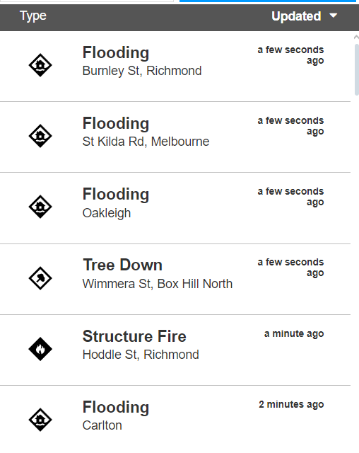
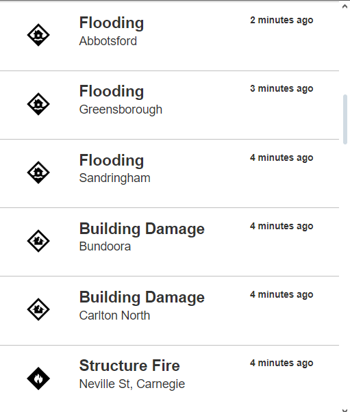
Ok folks, lots of #FlashFlooding around #MelbourneWeather areas.
Take it easy on the roads. Only travel if you really need to.
Keep updated via the Emergency Vic app:
https://www.emergency.vic.gov.au/respond/
Our weekend storm system could give a winter wallop to areas north of us around the I-70 corridor. Some snow here, but also the potential for heavier rainfall with a marginal risk of #FlashFlooding possible.
Stay tuned to @WDEFNews12 for updates.
#TropicalStormSara to unleash life-threatening #flooding in #CentralAmerica
Tropical Storm Sara will bring an extreme risk to lives and property in Central America where feet of rain may fall before tracking toward #Florida next week.
By Alex Sosnowski, AccuWeather senior meteorologist
Published Nov 14, 2024
"Rain may pour down for days on the northern parts of #Nicaragua and #Honduras before shifting to eastern parts of #Guatemala, #Belize and southeastern #Mexico this weekend.
"A general 8-12 inches (20-30 cm) will fall in this zone, but a large pocket of 12-18 inches (30-45 cm) of rain is forecast from northern Honduras and Nicaragua, with an AccuWeather Local StormMax™ of 50 inches (127 cm).
"'This amount of rain will trigger major #FlashFlooding and #mudslides with the potential for catastrophic loss of life and tremendous damage,' AccuWeather Chief Meteorologist Jonathan Porter warned.
"Some communities could be cut off for days due to washed-out roads and bridges or blocked by debris flows. Demands for rescue and recovery efforts, as well as food and medical supplies, will be great in the wake of the storm in the region.
"Because of Sara's proximity to the #Caribbean for several days, it will likely not unwind fully. As a result, winds, waves and #StormSurge will blast the coast of #Honduras, eastern #Guatemala, #Belize and Mexico's #Yucatan Peninsula. Sporadic #PowerOutages are likely due to #StrongWinds."
#CentralAmericaWx #ExtremeWx
#ExtremeRains #ExtremeWeather #ClimateChange #ClimateCrisis
#ClimateCatastrophe
🚨 Weather heads up! An #AtmosphericRiver is set to bring heavy rain to the coast and mountain snow to the Pacific Northwest & Northern California this Wednesday. ⛰️ Meanwhile, thunderstorms and heavy rain could cause flash flooding in parts of the Lower Ohio, Tennessee & Mississippi Valleys. 🌧️ Stay safe & stay informed! #FlashFlooding #StormAlert #Weather
Current sitution in #NorthCarolina, as best I can piece together:
EasternNC: #tornadoes continue to be a threat.
CentralNC: sporadic tornadoes, but the worst mostly seems to have moved north
Western Piedmont/Foothills: major (and I mean potentially catastrophic) #flashflooding is coming your way, even after #Helene moves through and the sun is shining again.
WesternNC: seems like the rain has passed, but OMG the #flooding is the worst in history.
Client Info
Server: https://mastodon.social
Version: 2025.04
Repository: https://github.com/cyevgeniy/lmst