RE: https://expressional.social/@Peter_Link/115707766631221810
People are dying right now from Storm Byron.
RE: https://expressional.social/@Peter_Link/115707766631221810
People are dying right now from Storm Byron.
https://www.gulfchannels.com/351807/ المساجد في إندونيسيا لم تسلم من غضب الفيضانات #agriculture #Business #disaster #Disaster(general) #Environment #flood #ForestryAndTimber #InternationalNews #NaturalDisasters #news #Religion #Ticker #أخباردوليّة

Well. The Mount Vernon floodwall held. Or has, so far, but the record-setting crest has passed so the prospects are looking pretty good.
Now to reinforce it because worse will be coming.
Also: People were wondering how much of the 100,000 people under evacuation order were in Skagit County, since that number covered the entire affected area, not just Skagit.
I finally got an answer:
78,000
That's the Skagit County floodplain number by itself. The other 22,000 were in other parts of the flooding area, particularly Snohomish County, but also some areas in King County up around North Bend and also areas around Green River.
#wawx #SkagitCounty #WashingtonState #flood #floods #flooding #cascadia
Warnings: Climate is breaking, weather is breaking. Life giving rain, is turning into life taking "rain rivers" soil washed away, farms washed away, livestock killed.
They aren't saying how many farms and livestock have been lost, "because chicken farmers are in trauma"
It is MADNESS to ignore these devastating warnings and expand oil, MADNESS to build pipelines.
MADNESS.
#cdnpoli #canada #carney #flood #fire #storm #drought #madness #cbc

Lower Mainland communities like Surrey, White Rock, and Abbotsford, plus a few neighbours in Washington, are on a temporary island today as the Nooksack River backs up into Sumas Prairie. #BCstorm #WAwx #weather #flood
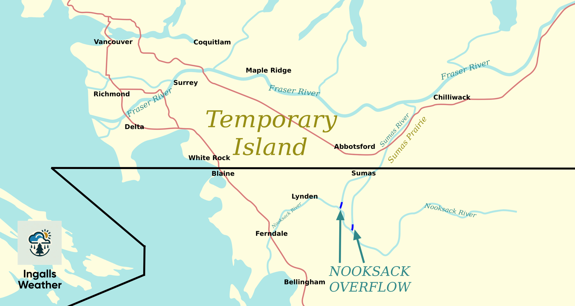
Lower Mainland communities like Surrey, White Rock, and Abbotsford, plus a few neighbours in Washington, are on a temporary island today as the Nooksack River backs up into Sumas Prairie.


If you were planning to visit Leavenworth WA anytime soon, don’t. Major power outage and lots of storm damage.
City press release
https://cityofleavenworth.com/your-city-hall/news-notices/joint-press-release-atmospheric-river-and-powerful-winds-impact-leavenworth-and-the-village-of-lights/
#PNW #WAwx #Seattle #Flood #SevereWX

Good news. For today and tomorrow western Washington State is mostly getting a break from the heavy rain. Rivers have crested at some locations and water levels are starting to drop.
The state emergency management staff puts out a status report near the end of each day. The screenshot has a list of U.S. and state roads that are closed. Of course many county and local roads are also out of service. Yesterday’s report is at
https://content.govdelivery.com/attachments/WAMILITARY/2025/12/12/file_attachments/3491979/SEOC_Sitrep-25-4783_12112025.pdf
#PNW #WAwx #Seattle #Flood #SevereWX

This drone footage is of the SNOHOMISH River, not the SKAGIT, which has also already officially set a flood record:
#Snohomish #SnohomishCounty #SnohomishRiver #flood #floods #flooding #wawx #DroneFootage #WashingtonState #AtmosphericRiver #cascadia
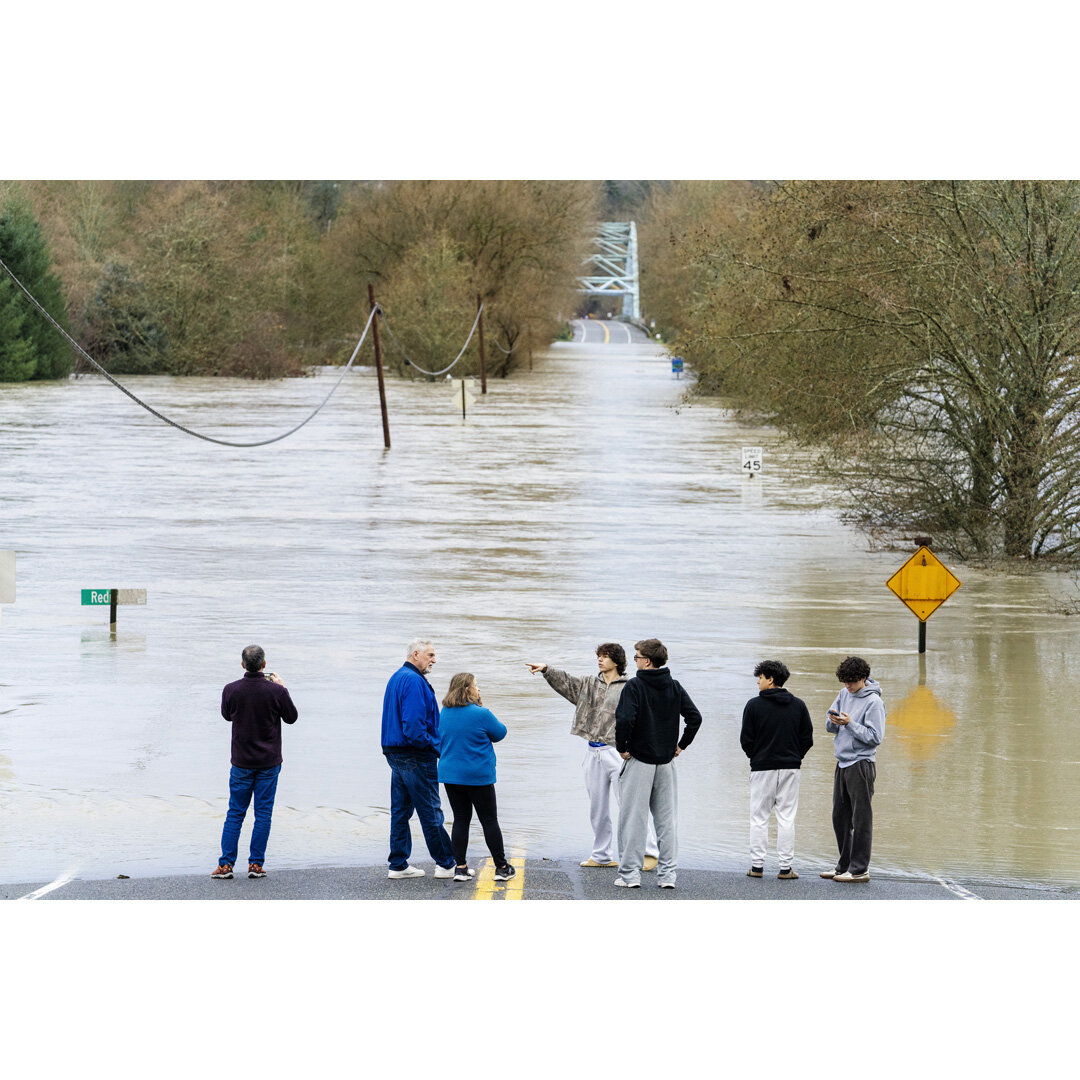
Flooding has reportedly crossed Highway 20 in Sterling, west of Burlington. If you are still there, somehow, GET OUT NOW. Recommendation is to evacuate via Collins or Gardner, then west to I-5.
People may want to notice how close this is to Burlington, which has very little elevation advantage over Sterling, if any.
Source: https://m.ai6yr.org/@easwatch/115703997607996422
#wawx #SkagitCounty #Burlington #sterling #flood #flooding #floods #WashingtonState #cascadia

There was a bit of a pilgrimage, many people of all ages paying respect to the river, the awe-inspiring reminder that we are, in reality, very small.
This is by the parking lot of the trail. There is a small wall by the partially submerged bushes, and a picnic table somewhere under there. It's eerie how disorienting the landscape had become.

I went back to the Snohomish River today, at Lowell Riverfront Trail in Everett. The spot from where I took the picture yesterday -by the picnic benches- had already flooded (current level 33'). The trail was flooded in spots, some areas a couple of feet underwater. Waterfowl were enjoying themselves.
The railways didn't flood. I believe most of the water flooded Ebey Island instead, which looked like a second river on the other side of the bank.


The footage of the Skykomish river at 5:10 is insane. That's guaranteed death water.
Some good drone footage here of Hamilton, WA in Skagit County. They're right next to the Skagit river, and just from looking back and forth from Google Maps (thanks to that big ugly building near the bright blue house), as of this morning they're under 3-5ft of water. Bad times. Most of those people will probably have to live somewhere else through this winter, because I doubt anything is getting remediated there soon. Hopefully everyone evacuated.
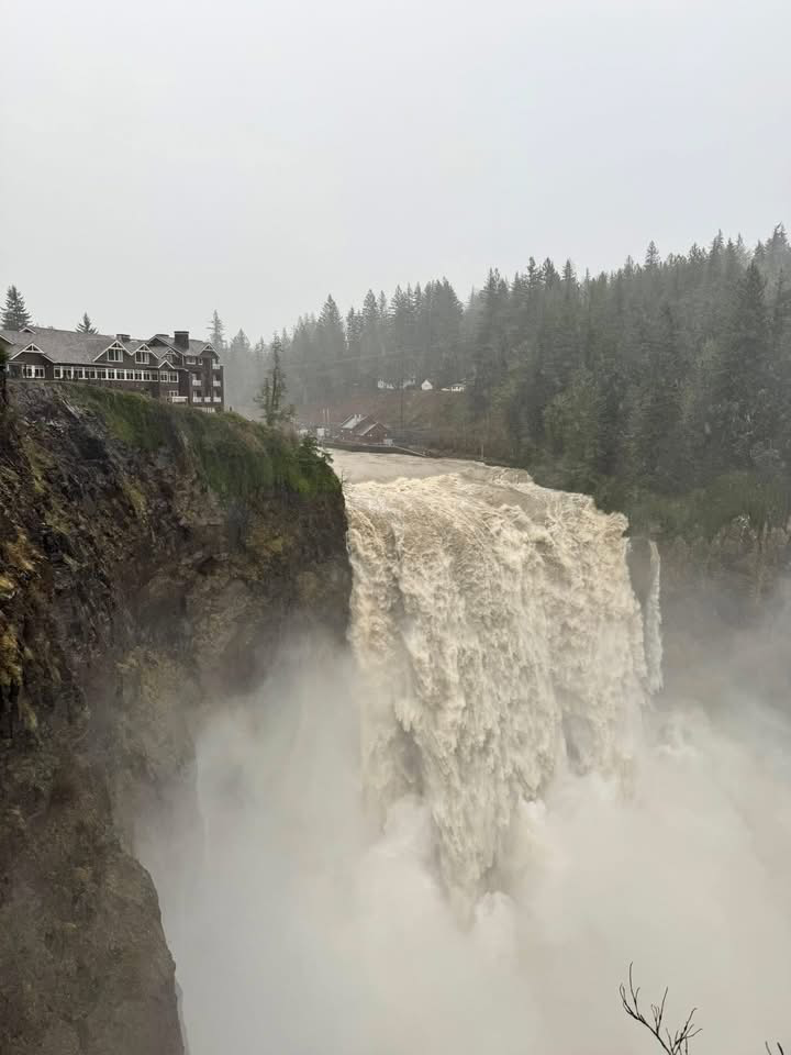
Snoqualmie Falls in Washington, two days apart. Water knows no master.
#flood #washingtonFlooding

This is from a few hours ago but:
If the link doesn't work here's the map.
#seattle #flood #floods #flooding #WashingtonState #wawx #cascadia

🚨 Green flood alert in Iraq
The flood caused 4 deaths and 4272 displaced.
More details: https://www.gdacs.org/report.aspx?eventid=1103655&episodeid=2&eventtype=FL
🚨 Green flood alert in Canada
None
More details: https://www.gdacs.org/report.aspx?eventid=1103659&episodeid=1&eventtype=FL