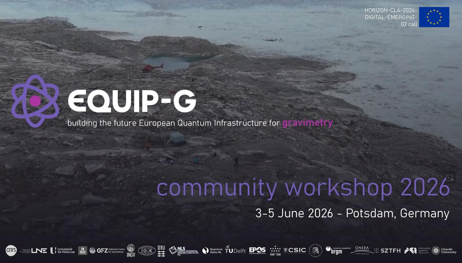
📣Contribute to shape the future of #gravimetry in Europe!
First #𝗘𝗤𝗨𝗜𝗣-𝗚 𝗘𝗨-𝘄𝗶𝗱𝗲 𝗶𝗻-𝗽𝗲𝗿𝘀𝗼𝗻 𝘄𝗼𝗿𝗸𝘀𝗵𝗼𝗽🇪🇺
📅3-5 June, 2026
📍Potsdam, Germany
𝘙𝘦𝘨𝘪𝘴𝘵𝘳𝘢𝘵𝘪𝘰𝘯 𝘯𝘰𝘸 𝘰𝘱𝘦𝘯!
👉https://events.spacepole.be/event/268/
📣Contribute to shape the future of #gravimetry in Europe!
First #𝗘𝗤𝗨𝗜𝗣-𝗚 𝗘𝗨-𝘄𝗶𝗱𝗲 𝗶𝗻-𝗽𝗲𝗿𝘀𝗼𝗻 𝘄𝗼𝗿𝗸𝘀𝗵𝗼𝗽🇪🇺
📅3-5 June, 2026
📍Potsdam, Germany
𝘙𝘦𝘨𝘪𝘴𝘵𝘳𝘢𝘵𝘪𝘰𝘯 𝘯𝘰𝘸 𝘰𝘱𝘦𝘯!
👉https://events.spacepole.be/event/268/
🎉The IAG has partnered with the UN Global Geodetic Center of Excellence (UN-GGCE)
Also the National Geographic Institute (NGI)🇧🇪 and the @ORB_KSB are proud to represent Belgium as a key partner of the UN-GGCE, and are committed to combine their expertise and resources in #geodesy🌍 to enhance global geospatial initiatives

#EQUIP-G project is focused on building the future European Quantum⚛️🇪🇺 Infrastructure for #gravimetry
Proud to be part of it!

#EUREF 2025 resolutions and new issue of the EUREF newsletter
Check it out!
👇👇
EUREF newsletter issue 6 https://www.epncb.oma.be/_documentation/newsletters/EUREF_Newsletter_2025_01.pdf
EUREF 2025 Resolutions https://www.euref.eu/sites/default/files/minutes/EUREF_2025_Resolutions_Paper.pdf

If I had a dollar every time someone said the haversine formula was "good enough", I could probably have a mediocre meal out. Vincenty all the time.
📣#EUREF symposium 2026🌍🛰️
📍Paris
📅23-25 June 2026
Important deadlines:
- abstract submission: April 23
- early registration fees: April 23
- regular registration: May 10
👉https://euref2026.sciencesconf.org.
#geodesy #referenceframes #GNSS #EPN_CB

RE: https://spore.social/@minouette/114036206774374378
Gladys West died January 17 at age 95, leaving behind an extraordinary legacy in mathematics and geodesy.
My portrait and bio are below.
#womenInSTEM #BlackInSTEM #mathematics #satellites #geodesy #EarthScience
Obituary:
you could use an oblique Mercator projection, but that only makes one side of the northern hemisphere larger
https://en.wikipedia.org/wiki/File:Mercator_Polar_Transverse.gif
#mapprojection #geodesy
https://en.wikipedia.org/wiki/Gladys_West
"Before GPS became an everyday utility, it was a hard mathematical problem.
In 1950s–70s, Gladys West - mathematician @ U.S. Naval Surface Warfare Center in Dahlgren, VA - worked on one of the most difficult challenges in satellite navigation: accurately modeling the Earth itself.
Modern GPS accuracy depends on:
• Precise satellite ephemerides
• Accurate gravitational field modeling
• Correct Earth reference frames
West’s work directly advanced all three
Her contributions weren’t widely recognized; it wasn’t until 2018 that she was inducted into the USAF Space and Missile Pioneers Hall of Fame - decades after GPS reshaped global navigation, logistics, finance, defense & mobile computing...
Before GPS could tell us where we are, someone had to define what the Earth actually looks like mathematically…”
#Engineering #GPS #Geodesy #STEM #TechHistory #WomenInTech #DataScience #Infrastructure #WomenInGeoSpatial
H/T Evan Kirstel [despite their puerile AI-generated image of Ms. West]
![photo - Ms. West and Sam Smith look over data from the Global Positioning System at Dahlgren in 1985
[https://en.wikipedia.org/wiki/Gladys_West]](https://files.mastodon.social/cache/media_attachments/files/115/799/917/381/307/524/original/77532a11143191b7.jpg)
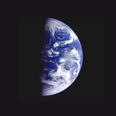
Spherical Earth (Cartography 🗺️)
Spherical Earth or Earth's curvature refers to the approximation of the figure of the Earth as a sphere. The earliest documented mention of the concept dates from around the 5th century BC, when it appears in the writings of Greek philosophers. In the 3rd century BC, Hellenistic astronomy established the roughly spherical shape of Earth as a...
https://en.wikipedia.org/wiki/Spherical_Earth
#SphericalEarth #Earth #Geodesy #Spheres #Cartography #AncientAstronomy
REMINDER
🗓️ Don't forget that at least one for the authors of an accepted abstract has to complete the online registration before 15 December 2025!
More info 👉https://geodesy.science/events/munich2026/
🌍 #geodesy #REFAG2026 #ReferenceFrames #GGOS #IAG


REMINDER:
𝗢𝗽𝗲𝗻 𝗖𝗮𝗹𝗹 𝗳𝗼𝗿 𝗘𝗮𝗿𝗹𝘆 𝗖𝗮𝗿𝗲𝗲𝗿 𝗥𝗲𝘀𝗲𝗮𝗿𝗰𝗵𝗲𝗿𝘀
EPOS-GNSS TCS Participation in #EPOS Days 2026
🗓️ Deadline to submit your application: 5 December 2025!
👉 https://geodesy.science/2025/open-call-ecs-epos-days-2026/
#geodesy🌍 #GNSS 🛰️🛰️🛰️
Earth orientation parameters (Earth 🌍)
In geodesy and astrometry, earth orientation parameters describe irregularities in the rotation of planet Earth. EOP provide the rotational transform from the International Terrestrial Reference System to the International Celestial Reference System, or vice versa, as a function of time. Earth's rotational velocity is not constant over time.
📢 The International Association of #Geodesy (IAG) has released the Geodesists Handbook 2024 and the IAG Traverse 2023-2025
🔵 The Geodesist’s Handbook 2024 (https://geodesy.science/iag/resources/general/geodesists-handbook-2024/)
🔵 The IAG Travaux Report 2023–2025 Volume 44 (https://media.geodesy.science/iag/travaux/2023-2025/iag-travaux2025.pdf)

#PlaneAlert ICAO: #343517 Tail: #ECLJN Flt: #ICC02
Owner: #InstitutoCartograficodeCatalunya
Aircraft: #B200GT Super King Air
2025-11-19 12:59:19 CET
#BE20 #Geodesy #AerialCartography #SpacialData https://www.icgc.cat/
https://globe.adsbexchange.com/?icao=343517&zoom=7&lat=41.322281&lon=2.152466×tamp=1763553559&showTrace=2025-11-19
#adsb #planefence #planealert by kx1t - https://sdr-e.com/docker-planefence


New user feedback survey!
https://gnss-metadata.eu/site/survey2
Help us identify how #M3G can further improve its support to #GNSS🛰️🛰️🛰️ data providers and users!
📅 Please submit your answers by Dec. 15, 2025
👉https://epncb.oma.be/ftp/mail/EUREF/eurefmail.12297
👉https://gnss-metadata.eu/
#geodesy #EPN_CB #EPOS #EUREF

#PlaneAlert ICAO: #342087 Tail: #ECIRV Flt: #ICC03A
Owner: #InstitutoCartograficodeCatalunya
Aircraft: #Cessna 208 B
2025-11-17 13:12:02 CET
#C208 #Geodesy #AerialCartography #SpacialData https://www.icgc.cat/
https://globe.adsbexchange.com/?icao=342087&zoom=7&lat=41.600971&lon=1.768610×tamp=1763381522&showTrace=2025-11-17
#adsb #planefence #planealert by kx1t - https://sdr-e.com/docker-planefence


#PlaneAlert ICAO: #342087 Tail: #ECIRV Flt: #ICC03
Owner: #InstitutoCartograficodeCatalunya
Aircraft: #Cessna 208 B
2025-11-16 12:11:12 CET
#C208 #Geodesy #AerialCartography #SpacialData https://www.icgc.cat/
https://globe.adsbexchange.com/?icao=342087&zoom=7&lat=40.575027&lon=0.426758×tamp=1763291472&showTrace=2025-11-16
#adsb #planefence #planealert by kx1t - https://sdr-e.com/docker-planefence