#geoData

Amᵃᵖanda 🔜 CFCamapanda@en.osm.town
2025-06-12

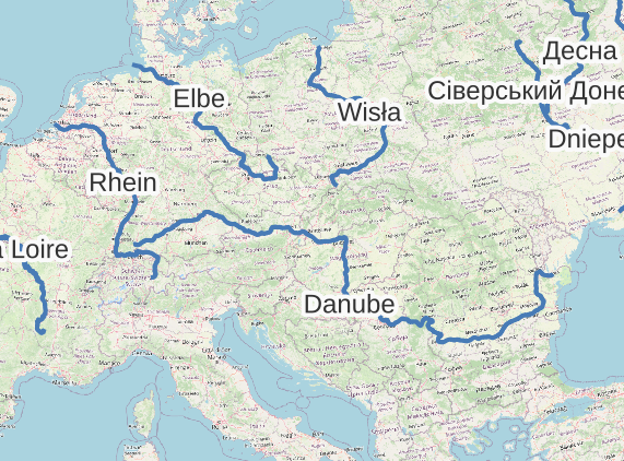
awww yeah. 😎💪💫 After a few years, I've given in and added support for waterway relations in #WaterwayMapOrg code.

Notice how the Rhein, Elbe & Danube are all connected up as a single feature with the same name? It's using the `name` tag from the relation to match them up.

this is preview, WWM code will update haha soon enough. This'll mostly be useful for the River database list.
#maps #geodata #OSMDataProcessing

map of central europe, with a blue line for the following rivers & their names: Rhein, La Loire, Elba, Wisla, Danube
Stuart Langridgesil
2025-06-10

I feel like there ought to be a better way to do this, but I don’t know what it is, so if any or types want to jump in with the trivial easy answer, I’d be happy to hear it.
Obviously this is subject to fairly substantial gerrymandering about what’s in your “important enough cities/points” list. I got one of 10k cities from a GitHub repo. (Simplemaps has one of 40k cities which is too big a list.)

2025-06-05

🔍 Nouveau sur le blog : QGIS & GeoParquet

Un format léger, rapide, cloud-friendly, parfait pour les SIG modernes !

📦 Moins de place, plus de perf
🧰 Lecture/écriture directe dans QGIS
🌍 Compatible avec les outils big data

📖 sigterritoires.fr/index.php/qg

#QGIS #GeoParquet #SIG #GeoData #OpenSource #FOSS4G

2025-05-19

Hvilket sted har et kommunenummer Kartverket godkjenner for tinglysing av eiendom, men kommunen finnes ikke i SSBs offisielle liste over norske kommuner?

#Norsktut #unntakstilfeller #geodata #programmering

Andrea Navarroandrea_navarro
2025-05-07

🗺️ ¿Querés crear mapas interactivos en Python sin complicarte con JS?

Escribí una introducción práctica a Folium, una librería que te permite generar mapas usando Leaflet desde Python.

Ideal para proyectos de ciencia de datos, visualizaciones geoespaciales y más.

📍 juncotic.com/folium-y-los-mapa

Mr. Framework :verified_bi:akalanka@masto.es
2025-05-05

🛠️ El puente, que debería seguir recto... se parte en dos! Esto se debe a que, en Hong Kong, Google ha decidido usar el sistema global, y no encaja exactamente con el chino, usado en Shenzen

#Cartografía #GIS #Geo #GeoData

Imagen en google maps donde se ve, claramente, que el puente se rompe en dos en la frontera HK-China
andypiper's bookmarksandypiper@pipesmarks.glitch.me
2025-04-25

Geoapify APIs Documentation
"Get started with Geoapify APIs. Access detailed documentation on geocoding, routing, and map services to create powerful location-based applications."

#geo #geodata #api #programming #geolocation #maps #mapping

2025-04-18

Popular CLI packages for the #Ajv Json Schema Validator don’t like data files with #geojson file extension. My #AjvGeoJsonShim wraps your ajv-cli so you can do this:

$ ajv-geojson-shim validate -s schema.json -d data.geojson

github.com/tomkyle/ajv-geojson

#AjvCli #JSON #validator #OpenData #geodata

2025-04-10

Using satellite imagery and advanced spatial modelling we are collaborating with #UNHCR to innovate mapping of displaced populations and unlocking the power of registration data.

By WorldPop data scientist Edith Darin and others.

#refugees #geodata #mapping

medium.com/unhcr-innovation-se

sabmansabman
2025-04-04

youtube.com/watch?v=YhkbML4R2z8

this was fun to make - took me 1 hour to go from idea to working prototype - thanks to geobase.app APIs & ecosystem!

🌍 Build a city health Viz with Geobase, DuckDB-UI & GeoParquet

❤️Appreciate the open data from , EmotionalCities and

@EUScienceInnov

2025-03-22

@Seeker @maexchen1 #openstreetmap hat ja keine Tourendaten. Eigentlich ist so eine Komoot Tour ja auch nur ein Gpx Track, ein paar Waypoints, Fotos, wäre schön dafür ein offenes Format dafür zu haben, dann könnten sich darum ein paar Apps tummeln und das beste gewinnt, oder? #opensource #geodata

2025-03-17

Open data at a glance: #ASIT has published an #opendata guide for #geodata. The guide covers the essentials and strikes a very nice balance with respect to covering the topic in enough depth to be valuable, while not being trivial and also not covering every tiny detail....
spatialists.ch/posts/2025/03-1 #GIS #GISchat #geospatial #SwissGIS

Leibniz-IÖR Dresdenioer@wisskomm.social
2025-03-12

Friendly Reminder: Beim #GirlsDay am 3. April könnt ihr mit uns in die Welt der Geoinformatik eintauchen und eure eigene digitale Karte erstellen. 🗺️!

Technik (und Verpflegung) werden gestellt.

🚨 Wusstet ihr schon, dass ihr euch für den #girlsday von der Schule freistellen lassen könnt? 🚨 Formular auf unserer Website ioer.de/presse/aktuelles/girls

Anmeldung 👉 girls-day.de/.oO/Show/leibniz-

#GirlsDay2025 #GeoData #Geoinformatik
@SLUBDresden @vhsdresden @UnischuleTUD @fffdresden @tudresden

Zwei Mädchen sitzen nebeneinander vor einem Laptop, auf dem eine Karte zu sehen ist. Weißes Banner mit blauer Schrift unten links: Girls’Day 2025 am IÖR in Dresden; Erstelle deine eigene digitale Karte!; 3. April 2025 | 10 bis 15.30 Uhr | Weberplatz 1, Dresden. Rechts daneben: Logo „Girls’Day | Mädchen-Zukunftstag“.
Leibniz-IÖR Dresdenioer@wisskomm.social
2025-03-10

💡 Innovative ideas in the field of spatial #SustainabilityTransformation research? We invite leading scientists to apply for an #IOER_Fellow|ship to jointly advance the spatial sustainability sciences. 📅 Apply until 12 May 2025! Learn more 👉🏻 ioer.de/en/career/ioer-fellows

#LivableFuture #CircularEconomy #ClimateAdaption #LandUse #GeoData

@S4F @NFDI @BERD_NFDI @nfdi4earth @konsortswd

Blue background with building structures, a larger green circle on the right, smaller white circles are connected to it in a radial pattern. Text: Advance your resaerch space. Apply now for an IOER Fellowship.
Alexandre B A Villares 🐍villares@ciberlandia.pt
2025-03-02

«"Geocomputation with Python", a book on reproducible geographic data analysis with open source software.»

py.geocompx.org/

#GIS #geodata #FLOSS #Geocomputation #Python

2025-03-02

1.-7. marts 2025
Open Data Day - #ODD - #opendataday - er en årlig fejring af åbne data over hele verden.

Grupper laver lokale events, hvor de bruger åbne data i deres lokalsamfund og flere er relateret til åbne #geodata #openstreetmap

Foreløbig 168 evente egistreret
opendataday.org/

ODD vedligeholdes og støttes af Open Knowledge Foundation #OKFN

✉️ Info-CNIG – Février 2025 est en ligne !

Bertrand Monthubert analyse l’apport des données citoyennes à l’intérêt général 💡

🔎 À lire aussi :
🗺️ Mobilités & téléphonie mobile
🏗️ Référentiel National des Bâtiments : contribuez !
♿ Accessibilité : échanges les 13 mars & 5 avril.
🏙️ Ville durable : colloque le 21 mars.
🌍 GreenData4All : consultation avant le 30 avril 🌿

📖 Lire ici 👉 nouvelle-elettre.developpement

#Géodata #DonnéesOuvertes #VilleDurable

Client Info

Server: https://mastodon.social
Version: 2025.04
Repository: https://github.com/cyevgeniy/lmst