#peakbagging

2025-12-10

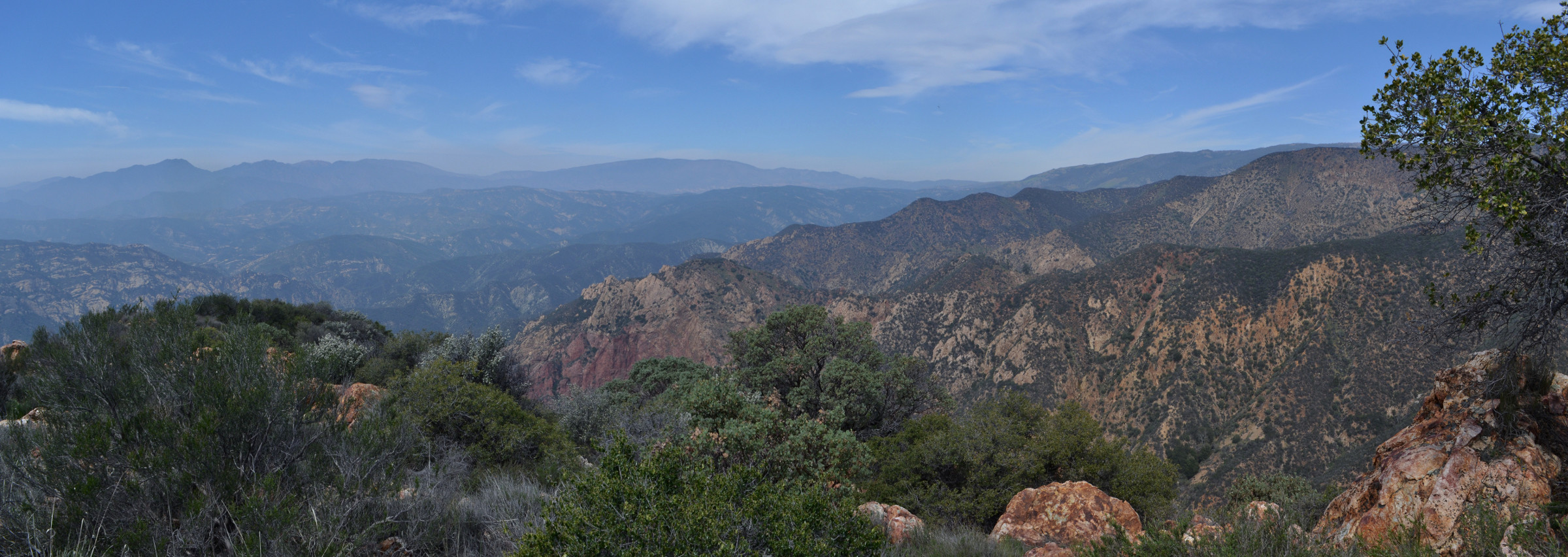
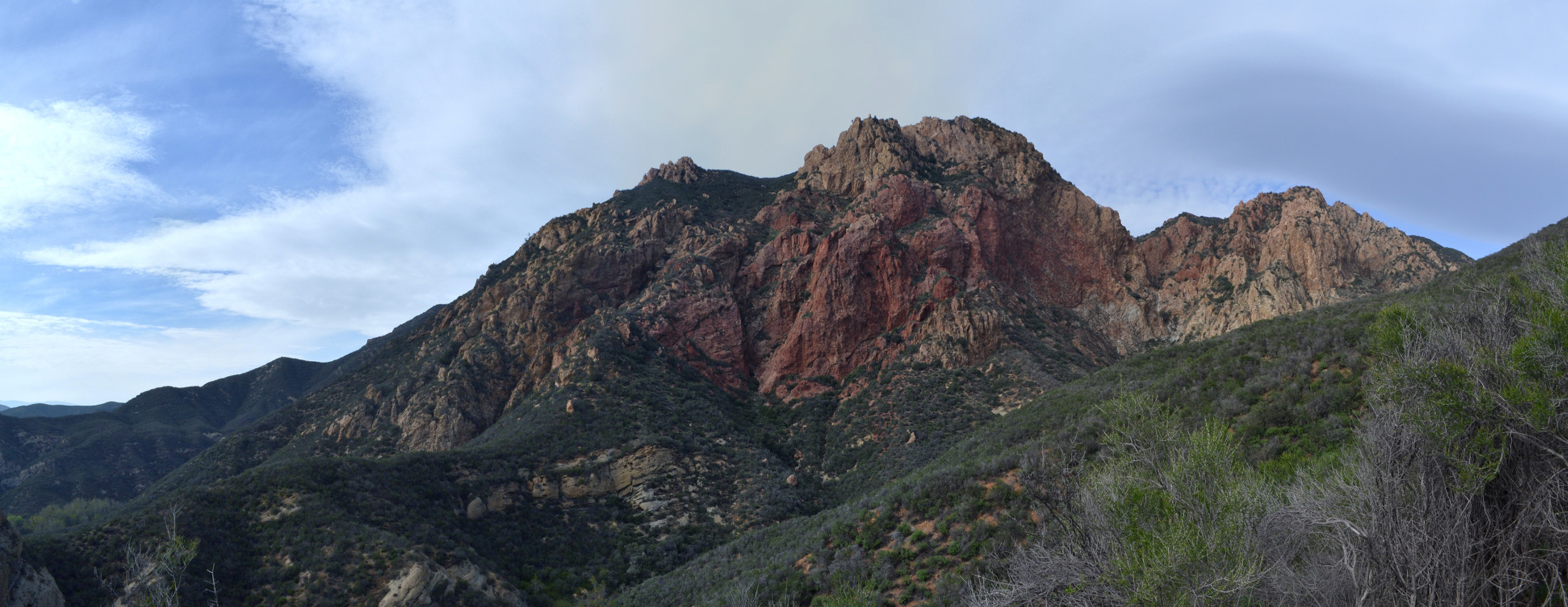
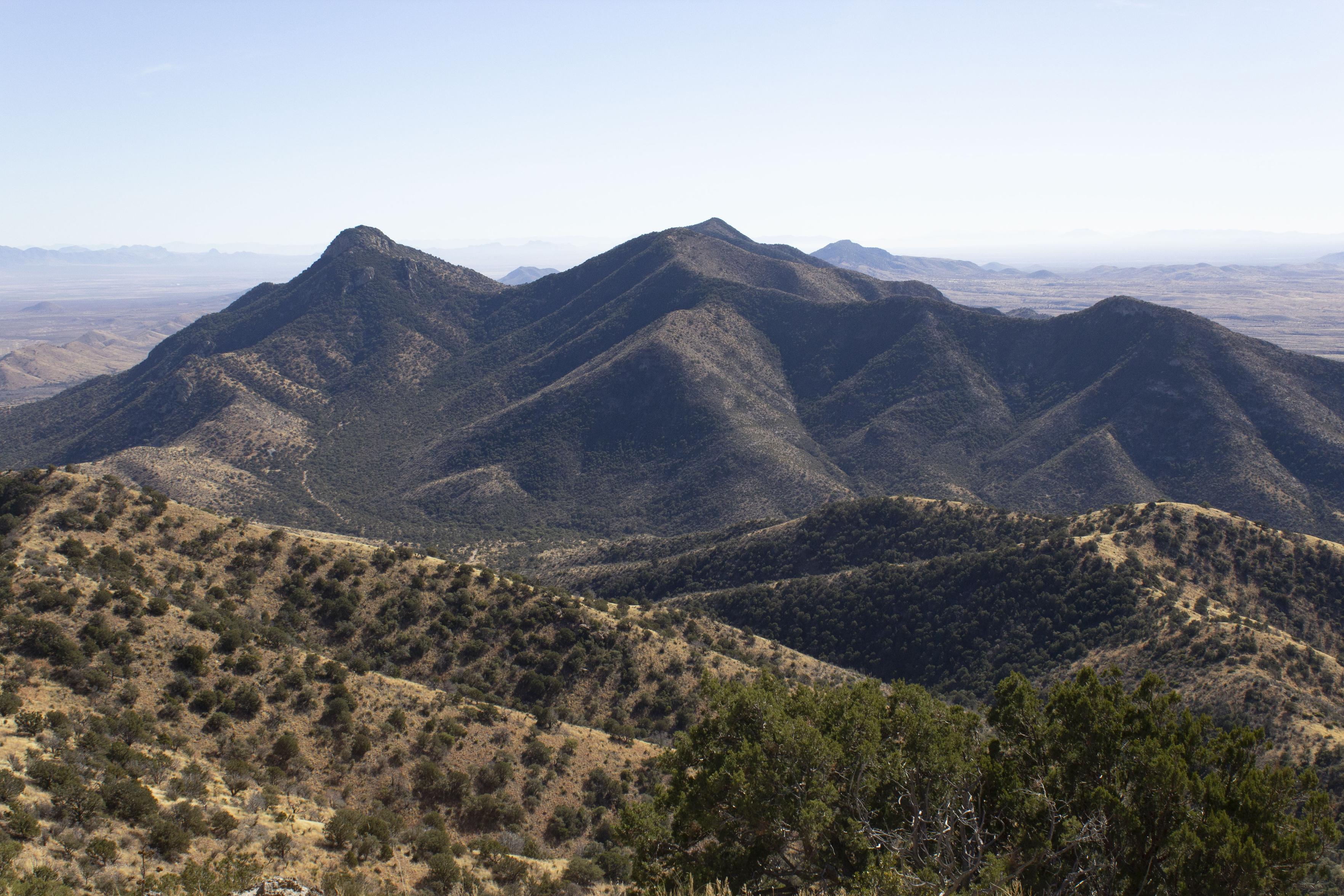
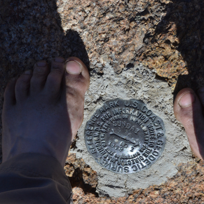
A few feet from the very top of the HIGHEST peak in ALL of California's coastal ranges (taller than the coastal ranges of Oregon and Washington, too) and this thing pops up into view.

...

First look at the mighty Mount Shasta while on the way up Mount Eddy. Eddy stands 9k feet (2751m), with 5k feet (1556m) prominence, but Shasta overshadows it a bit at 14k feet (3417m).

#hiking #peakbagging #peak #mountain #nature #landscape

A very rugged and snow covered peak pokes out behind a foreground of rough stones, generally orange and green and grey, with very little vegetation, all under a sky of thin clouds.
2025-09-26

Day 3 was moving day and had lots of free time, so I got to hike the Wilderness high point, which happens to be the Mendocino National Forest high point too!

More here: valhikes.blogspot.com/2025/06/

#California #TehamaCounty #MendocinoNationalForest #YollaBollyMiddleEelWilderness
#hiking #nature #landscape #travel #hike #outside #backpacking #peakbagging #peakbagger #volunteering #NRT #BigfootTrail

The one bit of snow on trail almost to the junction with the South Yolla Bolly Trail.

Rockyu soil of a ridge with a trail extending outward. A finger of snow crosses the trail. Trees stand in a group on the far side and off to the right on this side. Distant peaks are visible between.Spring beauty of an alpine sort.

A ball of red leaves yields a bud and a flower and many old blooms. It squeezes out in a break between grey rocks.South Yolla Bolly (Mount Linn) from its lesser peak to the west.

Grey rocky ground drops through a thin and long stand of conifers to a higher point far and right. Snow strips extend downward to the left off that far point. A distant ridge crosses the space behind, where it can be seen.Long Lake below the ridge between South Yolla Bolly peaks.

Looking down into a wide valley from high on one side. Trees start below and get thicker far below. On the far side, things become rocky again.
2025-09-17

I was very pleased that I made it up to the top of Cerro Grande. A few months ago, it would have been out of the question, but now I'm on some meds that are helping a lot. The doctors are still mystified as to what's actually wrong with my heart and what that means for the long term, but at least I can hike and hike while they figure it out.

Also: lots of #elk bugling. I couldn't find the sound recorder app on my phone, so I used Merlin to record a few clips.

#hiking #NewMexico #PeakBagging

Looking along a ravine on a mountain, leading up to a peak in the distance. The sky is full of puffy cumulus clouds and the light is varied between small areas of light and bigger areas of cloud shadows.A wide panorama from a meadow on the upper slopes of a mountain peak. There are a couple of hikers visible, slogging up the trail. At  the far right you can see a little bit of the rocky trail we came up. The meadow is made of clumps of tall bunchgrass, in shades of green and yellow, with a few trees at the verges. Beyond and below, there's a big series of valleys (the Valles Caldera) and lower mountain peaks (the resurgent domes of the Caldera). Farther in the distance you can see a small clumpy mountain (St. Peter's dome) and, almost lost in haze, the Ortiz mountains and Sandia Peak.
Patrick McConnellpatrickmcconnell
2025-09-17

Big new TestFlight build for Peakist, my , app. Adds support for tracking your grids (hikes in every season or month) and exporting visit data.

Also several more New England lists.

Works on iPhone, iPad and Mac. Full support for all the shiny new OS versions (and the old ones too)

testflight.apple.com/join/f9AS

2025-09-03

Today's hiking group destination was Deception Peak, elevation 12,320'. I am, sadly, not up to a climb like that right now, so here's a photo from 2020.

#hiking #NewMexico #PeakBagging

A view from a mountain peak, looking across to another peak of similar height. We're above the treeline, so the ground is covered with jagged rocks and no trees, though there's a little bit of lichen and low growth between the rocks. In  the distance you can see a few other peaks, slightly lower, with grassy bald spots at the top and trees lower. The sky is overcast.
2025-08-25

Day 4 was for returning, but there was enough time for one more peak and a visit to the triple point. Water from there variously goes into the Smith River (via middle fork), the Illinois River (via east fork), and Klamath River (via Clear Creek).

The details: valhikes.blogspot.com/2025/06/

#California #KlamathNationalForest #SiskiyouWilderness #SiskiyouNationalForest #RogueRiverSiskiyouNationalForest #SiskiyouCounty #DelNorteCounty #SmithRiverNationalRecreationArea

#hiking #nature #landscape #travel #hike #outside #backpacking #peakBagging #peakbagger

Youngs Meadow with El Capitan rising behind.
 
Looking down on a large patch of green, sparse trees in front and thicker beyond it. Past the trees, a mountain seems to rise near vertically with some trees at first, then just snow and rock. Clouds are traveling through the meadow from the left.Snow on the north side of Youngs Peak makes a less brushy traverse to the peak and triple point for a time.

Footsteps along the flat part of a bit of snow that piles onto the north side of a ridge that is all dark rock to the right. Trees poke out of the snow on the left and from the rocks at the right. The maker of the footprints is striding off making more.Looking back to the triple point and Youngs Peak from a further peaklet.

Brushy ridge with some flowers yields to rocky and cliffed, then brushy again with some trees then rocky as it extends into the distance and to the right. The last visible is a pointy high point just reaching out of the green brush. More peaks in the distance, some with snow on them. This one also has a blanket of snow decidedly on the right side.Siskiyou Iris

Bright yellow flower with three long fat petals lined in a deep purple and three narrower petals offset. Another set of three petals closes in on the first, larger set.
2025-08-25

Day 3 had thoughts of some diversions, then different, better, actual diversions while making some of the return. The higher, but not highest, peak was bagged.

The details: valhikes.blogspot.com/2025/05/

#California #KlamathNationalForest #SiskiyouWilderness #SiskiyouCounty #ElCapitan #notThatOne

#hiking #nature #landscape #travel #hike #outside #backpacking #peakbagging #peakbagger

On the way up El Capitan, looking to Preston Peak/Copper Mountain (left) and Bear Mountain (right, but the left one).

Looking down a rocky slope with pines and brush growing more densely toward the right. Past a saddle, more rocky with scattered green growth and snow patches rises to a high and snowy peak at the far left. The right is lower canyon and hill before rising to a pair of snowy peaks in the distance. All under a blue sky.At the top of El Capitan.

Rocky peak as center foreground. A ridge falls away in steps to the left, a snow patch reaching toward its top to more left. The rest of the land drops off quickly to a rolling landscape with cliffs and gentler hills for layer after layer after layer. The sky has lumpy clouds echoing below. (They're lenticular clouds.)Lazuli bunting in a dead tree.

A bird with a blue head and wings, brown chest, and tan underside looks out from a branch of a tree with white wood showing under pealing bark pieces.Unnamed waterfall off a stepped cliff.

Water drops sharply in a diagonal from right to left before rolling over high cliffs and falling. More cliffs abound in the area, but also places for pines to grow.
The Next Summitthenextsummit
2025-08-23

Would you support a permit system to reduce crowding on 14ers?

2025-05-05

North Yolla Bolly as it starts to get engulfed in clouds once more. But it did come out for a view! And there's a view of the thick on the north, gone on the south snow conditions for 6000+ feet.

North Yolla Bolly is the p2k that got passed over in favor of checking out the decaying fire lookout on Black Rock Mountain more closely. I'll have to be back for it one day.

#MountainMonday #peakbagging #hiking #landscape

Look past the dead tree centered in the middle to a ridge of generally live trees stretching away to a higher peak. The left side has a thick white blanket of snow reaching up to the top edge. The right is mostly clear of such stuff. Trees are much thicker on the left edge than the right, but the high peak is rocky. The ridge turns a little so that the peak looks quite snowy. Clouds coming from the right are quickly engulfing the top and approaching, but above, the rest of the ridge.
2025-05-05

After the hard work getting there, the last 2 of 8 miles fighting the fading trail and thick fingers of snow reaching from the north side, we decided against climbing the lookout stairs for the big reward of a superior view.

#hiking #hikingAdventures #silentSunday #fireLookout #peakbagging

The fire lookout at the top of Black Rock Mountain near North Yolla Bolly Peak in Yolla Bolly-Middle Eel Wilderness, northern California.

Snow coats the ground thickly, but rocks poke out at the furthest edge. One rock is topped with the decaying wooden frame of a fire lookout. Its deck has no railings, half the shudders visible are missing, as is the roof. The stairs stick out of the snow to the side finishing near the top of a rock. In the center is a small tree and a smaller lone figure walking toward the tower. All is hazy with a thin cloud that just wouldn't clear.
2025-03-20

For #ThrowbackThursday: #OnThisDay in 2017, I made a start in the faint dawn light at the end of Templin Highway to bag the Lower Peaks Committee (#SierraClub) listed Redrock Mountain. They list the benchmark, anyway. The actual peak was my goal and is a little further along the ridge. I skipped looking for any cursed gold mines the area is known for and went for the more reliable reward of beauty. The narrows of Fish Canyon, a diversion into the canyons past Pianobox when I missed a turn, then high into a clearing sky where the last wild California condor soared before all were captured. Once headed down again, I took a different route, a repeat of a stunning canyon I had hiked before, but this time with enough light to see it.

It was a wonderful day and the whole story is here: valhikes.blogspot.com/2017/03/

#hiking #dayhike #nature #canyon #peak #peakbagging #TbT #OTD

Where does short Templin Highway go anyway? If it was this way, perhaps the reason it was never completed is that it was such a bad idea. The old road through Fish Canyon occupies the entire canyon bottom at one spot.

Steep canyon walls drop to a concrete road plastered across the bottom. Water sheets thinly over it, pouring into deep holes. The edges of these holes show no surface under the nearby road pieces. A thick bit of vegetation is on the left side, but just ahead the canyon closes to the width of the road.Canyon beyond the Pianobox Prospect (now Camp).

Steep canyon walls rise nearly vertically on either side of a flat bottom with a small creek running along. Trees on the edge struggle upward for some light. Ahead, the top is visible where rock turns to green-grey bushes.Panorama view from near the REDROCK benchmark.

A shrubby ridge stretches right and near to left and further. Two more stretch similarly beyond it, also covered in green-grey shrubs at the top. The second has very red rocks below a peaklet near its further end. More lines of mountains stretch across the view beyond where things are murky with particulates in the air. The sky has thin, wide spots of white obscuring some of the blue.A view back to the red rock cliffs of Redrock Mountain.

A green topped triple peak with a face of starkly red rocks. The cliff is rough and tall. Nearer, long fingers of low ridge are topped with more green, but show a rounded white rock in short cliffs.
The Next Summitthenextsummit
2025-03-05

Despite the focus of my blog’s name, climbing mountains isn’t just about the summit—it’s about the journey and what you experience along the trail.

What keeps you coming back to the trails? 🥾💙

Paul McClellanglassmtns
2025-02-17

On Friday, February 7, I climbed Black Diamond Peak and Henry Peak (Peak 7155) in the southern Dragoon Mountains of Southern Arizona.

glassmountains.net/wp/black-di

Black Diamond Mountain (L) and Peak 7155 just in view to the south from Sala Benchmark
2025-02-13

#ThrowbackThrusday things to do in February: backpack spots around the Smith River. In 2017, I hiked Elk Camp Ridge, bagged an old fire lookout, and chickened out about a creek crossing that actually didn't look that bad compared to what I got up to later in that year.

More info in the alt but the whole story starts with this post: valhikes.blogspot.com/2017/02/

When the rain stops, I might try some more of this.

#hiking #backpacking #peakbagging #camping #walking #nature #California #NorCal

View northerly from the north end of Elk Camp Ridge. This spot also had a lot of evidence of the area's mining history.

A rocky ridge with squat manzanita scattered crosses in from the left. A treed ridge thinned by fire crosses in from the right behind it. A line of peaks, one quite conical and a little bit higher than the rest, crosses in the background. They are powdered white at the top. The sky is a clear light blue.Very little is left of the fire lookout on High Dome and the trees have cut off a lot of view.

A patch of flattened ground with thin snow over half of it, short rocks breaking through near to the photographer. Medium trees block off the view on the left side, growing up at the edge of the flat. Shorter trees and bushes on the right leave room for a little distant mountains to be viewed. Clouds are moving in overhead from the right.The crossing of Patrick Creek looked worrisome with swift, but knee high (give or take) water rushing through. The reward for crossing would have been a quarter mile to the planned camp spot by hot springs. The punishment for flinching and going back ended up pine needle tea as drinking water.

A trail extends from the middle, quickly only visible as a shallow ditch, then not at all as it enters swift waters flowing form right to left. Patches of white foam cover the water to varying degrees. At the far side, another shallow ditch turns back into trail. The water is edged by thin trunk trees and all is covered by their leaves.Sunrise on the third day. Camp was on the near peak to High Dome which had some open spots for views of the nearby snowy peaks.

Tall pine trees show views through the spaces formed by a past fire. A low, dark hill rises in the near distance. Higher mountains showing white patches of snow among dark rise behind them. The sky is pink above the distant snowy peaks. Not much snow is seen on the nearby ground.
Paul McClellanglassmtns
2025-02-09

On Tuesday, January 28, June Meyer and Bill Hiscox joined me on a climb of “Mescal Peak” in the far southern end of the Whetstone Mountains of Southern Arizona.

glassmountains.us/wp/mescal-pe

Mescal Peak from near our parking spot beside Arizona Highway 82.
Paul McClellanglassmtns
2025-02-08

On Friday, January 24, I joined a large Southern Arizona Hiking Club outing to climb Elephant Head, a rock buttress on the west end of the Santa Rita Mountains of Southern Arizona.
glassmountains.us/wp/elephant-

The South Face of Elephant Head from the Quantrell Mine Trail
2025-02-06

Things to do in February: bag desert peaks! For this #ThrowbackThursday I have a Feb 2022 hike up Corkscrew Peak in Death Valley, listed by the Desert Peaks Section. Unlike the last one, this was on my own like most my hikes. Some quick weather was expected to blow by in the morning, but it held off a couple hours. Without the weather, it would have just been boring blue sky all across the whole day.

The story's here: valhikes.blogspot.com/2022/02/

#hiking #dayhike #DeathValleyNationalPark #California #USA #peakbagging #DPS

Well worn use trail to Corkscrew Peak. That beautiful trail is not official, but the peak register at the top is.

A very well worn line of distinctly smoother and lighter ground winds along the top of a rounded hill, vanishing as it slopes down, then appears again as another slope climbs even higher before getting lost in topography and distance. On the right, the hill drops to a sudden cliff of one side of a shallow canyon. On the left, the further slope rises to a small peak with a ring of cliffs around its top. In the distance in the middle, there's other peaks rising and clouds forming over them. The rest of the sky is a deep blue. A scattering of grey tufts and a few thin creosote bushes are the few plants in the gravel.Looking back when high on that well worn but unofficial trail.

A well worn line of lighter and smoother trail descends a gentle slope toward a chute in the cliff band. A steep and textured rock rises on the right of the chute as the trail vanishes behind the slope. It drops to a lower level of light flats and washes broken by darker, short peaks. A tall, rounded peak rises on the left and beyond another. The distance is obscured by dust picked up by the wind. Few plants are seen and the sky is white.At the top with a couple snow flakes.

Looking out over a pair of occupied shoes, toes pointed up, slopes drop quickly past spears of rock to a valley. Conical hills arrange below to leave spaces for water to flow when it feels like it. White spots of a couple big snow flakes in the air are seen.Sign at the road pointing the way for the birds as the sky clears once more.

On the left, a sign at a sharp angle states "Corkscrew Peak" with an arrow and "elev. 5804 ft.". On the right, a peak with a top that looks to be going wide, then narrows quickly with a ramp of cliffs around the wide area. It does, somewhat, resemble a corkscrew of sorts. Above are puffy clouds and a little blue sky once more.
2025-01-30

#ThrowbackThursday In 2018, I spent a January day with the Hundred Peaks Section bagging my 100th listed peak. I should probably join up some time to get credit! They're a great bunch and allow all to come along even if you haven't joined. It doesn't even matter how many times.

For the whole story, the blog post is here: valhikes.blogspot.com/2018/01/ and if you want to keep exploring, click the HPS tag for more HPS peaks and the Sierra Club tag for more club outings.

#SanBernardinoNationalForest #California #HPS #peakbagging #hiking #dayhike #landscape #nature

Stumbling across mining history and gaining view on the way up.

In the foreground, a concrete ramp directs water from an abandoned mining area. Short brush surrounds it. A small ridge leads upward on the left populated by the few tall trees visible. Another ridge comes in from the right with a short tree at its top. Higher hills are visible in the distance, but fairly obscured. All under a blue sky with no snow on the ground.Resting around the first peak, one of the group occupying a low rock.

Long, flat ridges stretch across the distance. The ground is mostly covered by low bushes that grow in low density so a lot of the rock is visible. One rock in the foreground is occupied by a fellow who is not currently doing one of his wild poses or up a tree, his signature move. A couple other hikers rest around the bottom of the rock, one standing, chatting with him. A distant mountain range behind it all is covered over with a wispy cloud in an otherwise blue sky.More view of a jumble rock landscape.

Rocky short hills coming to points poke out of the sparse but green vegetation. It looks like low bushes, but some are clearly trees. A flat, tan bottomed valley leads to rounder, greener hills, then a blue mountain range. The sky is full of a very thin grey that could be cloud or smoke.Hiking down again. That is smoke in the upper left, but it is a controlled burn.

A few of the group seen hiking down a rocky hill. In foreground, rounded rocks. In the middle, a flatter land with rocky points sticking out. In the background, a taller mountain with a bit of white emanating from the top. Beyond that, a couple more mountains almost vanish behind the low hills. All under a fairly blue sky.

Client Info

Server: https://mastodon.social
Version: 2025.07
Repository: https://github.com/cyevgeniy/lmst