@GregCocks this is useful especially if her newsletter is on hiatus for the summer I believe.
J9C :arcgis: :python: :osm:
Marine Biologist | GIS Analyst | Humanitarian Mapper
Technical Account: Toots are mine.
Accessibility A11y: Toot + image + Alt text = Boost
Interests: #STEM #remotesensing #lidar #geology #python #EarthObservation #marinebiology #starwars #humantarianmapping #horses
Header: Landsat 8 image of the Appalachian region
Avatar: Map pin in a circle with a map background
Social Account: @EquineJ9
J9C :arcgis: :python: :osm: boosted:
Hey GIS mapping friends. I was a StoryMaps user for years for blogs, but the platform went away and I can't migrate to ArcGIS because I use a Chromebook (it's all I need).
BTW, everything I ever wrote has been deleted.
What do you think of Felt? It seems built for online-only users like me. I can embed the map into most blog platforms.
J9C :arcgis: :python: :osm: boosted:
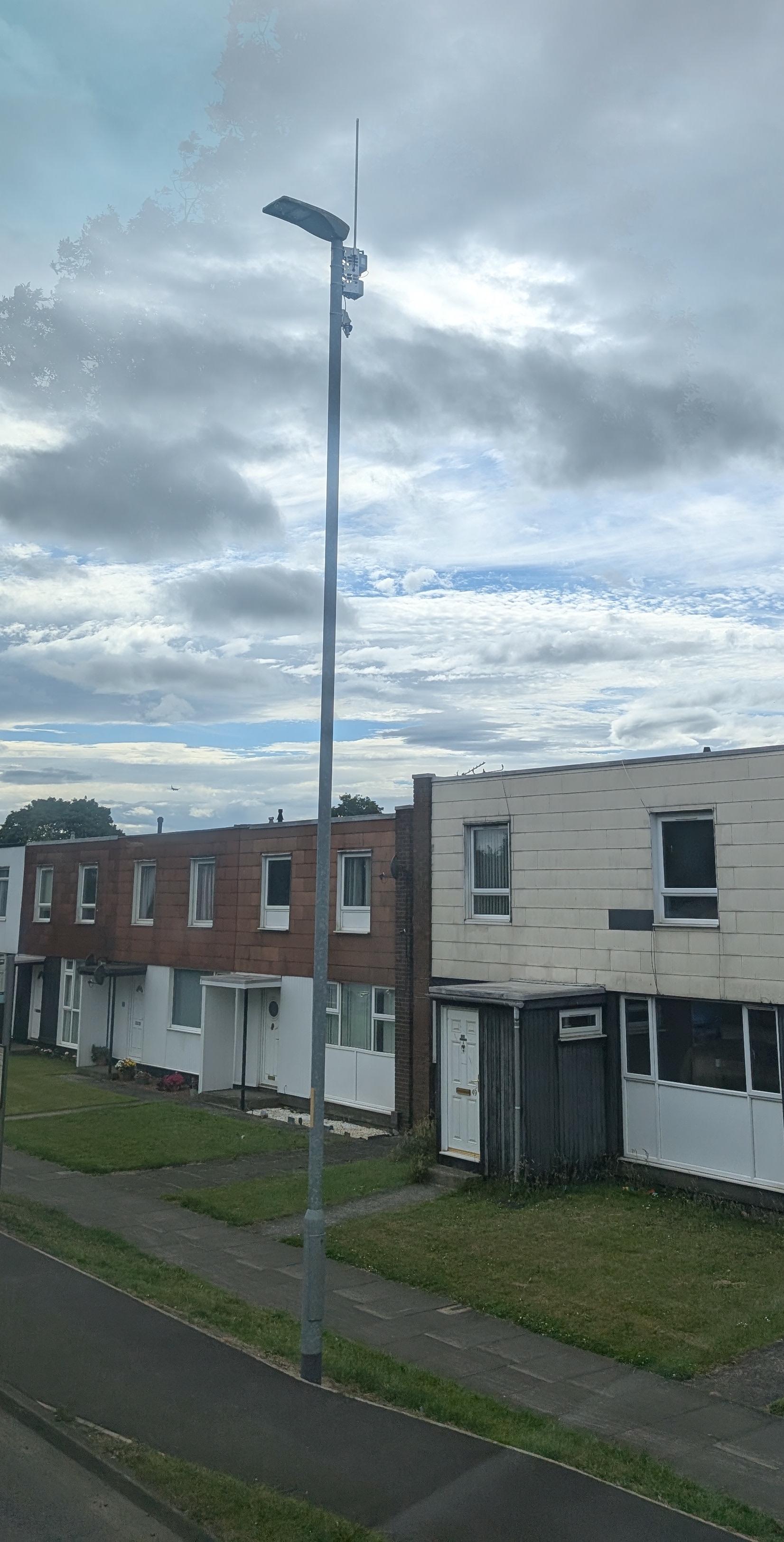
#OSM tagging conundrum for LoRaWAN remote utility meter reading base stations (Part 2)
Add-on to an existing street light pole.
This is a bit harder as it is both a street light, AND a base station:
highway=street_lamp
lamp_mount=straight_mast
lamp_type=LED
utility=water
communication:lorawan=yes ?
utility=water
operator=Northumbrian Water Limited
operator:wikidata=Q7059853
Any suggestions please?
(full post on Talk-GB email list
https://lists.openstreetmap.org/pipermail/talk-gb/2025-June/031795.html )
J9C :arcgis: :python: :osm: boosted:
I've saved off https://www.climate.gov/data/ but it's ~70GB and I don't have any way to personally host files that big.
https://mastodon.world/@ZLabe@fediscience.org/114738627845743569
J9C :arcgis: :python: :osm: boosted:
Animation visualising the speed of a bus route in #Edinburgh
36 from Morningside to Leith
Converted GPX to CSV in #QGIS, processed further in Python, and imported into Blender
(The dial in the top-left corner is a compass, pointing north. Height and colour represents speed)
J9C :arcgis: :python: :osm: boosted:
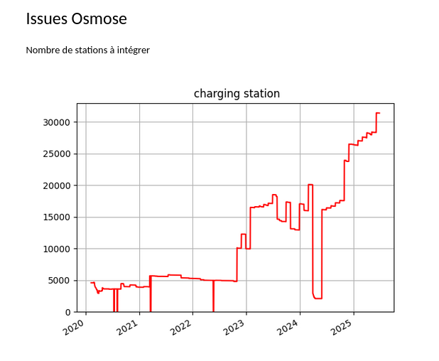
dites donc y'a pas loin de 30 000 bornes de recharges à intégrer et à placer minutieusement dans #OSM selon #Osmose, si la thématique des #IRVE et des #transports bas carbone vous intéresse, rejoignez nous!
J9C :arcgis: :python: :osm: boosted:
OpenStreetMap.org will be offline for the next hour due to maintenance while we fix an issue with OSM planet replication diff publishing. Sorry for the short notice. We will return services as soon as possible. #maintenance #osm #OpenStreetMap
UPDATE: Maintenance has been completed. Happy Mapping
J9C :arcgis: :python: :osm: boosted:
The #OpenStreetMap planet replication diffs are not currently updating. We are trying to get the issue resolved as soon as possible. #OSM
@lostmonkey nice! I hope to map public art in my area too. This is a great resource.
J9C :arcgis: :python: :osm: boosted:
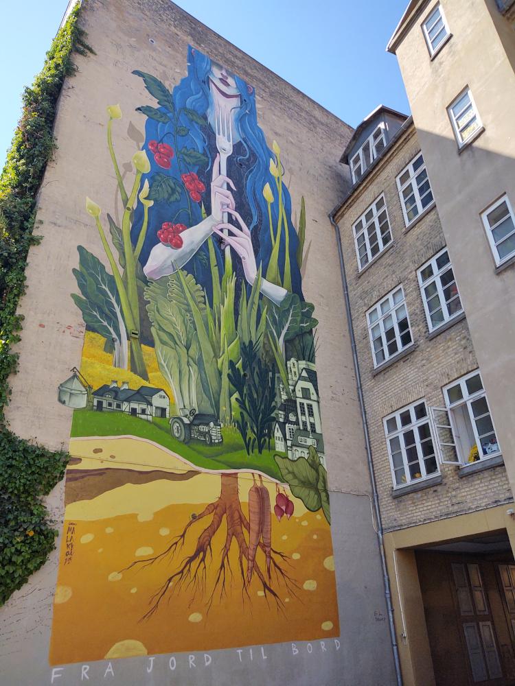
Visiting Aarhus and up for an art walk?
Here is a uMap showing the murals from the 17 Walls project – plus many other mural locations in the city (that are mapped in OpenStreetMap). A great way to explore Denmark’s second-largest city through public art.
👉 https://umap.openstreetmap.fr/da/map/17-walls-murals-in-aarhus-denmark_1228511
📍 Data from #OpenStreetMap
#OSM #aarhus #streetArt #umap #17Walls
J9C :arcgis: :python: :osm: boosted:
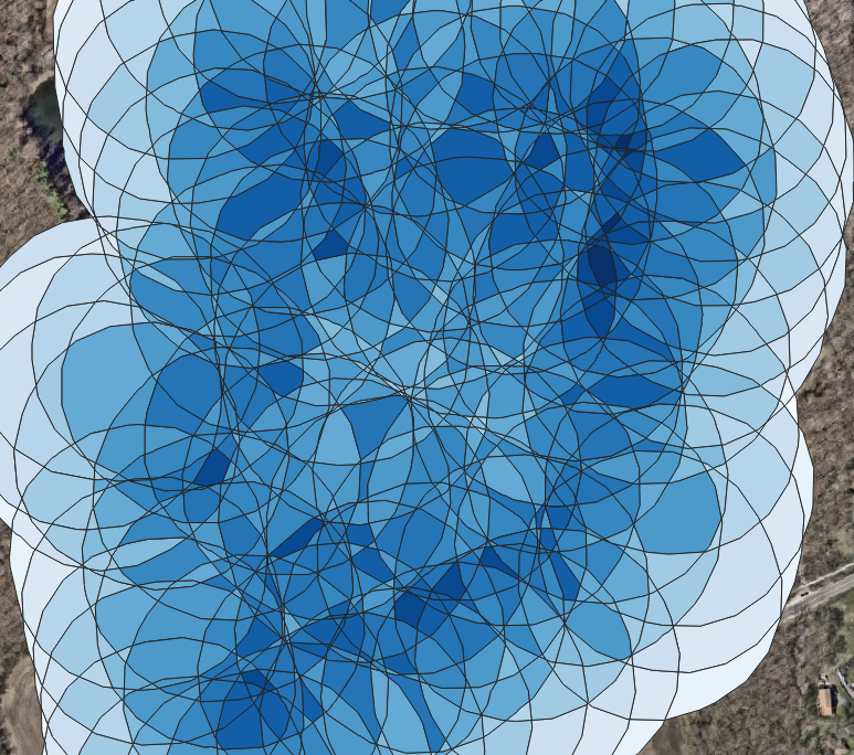
Got a #qgis question for you, #gischat.
I'm working with some buffers, and I'm looking for areas of overlap, and how many overlap in a given area.
Current process is:
Buffer → Split by Lines → Drop Duplicate Geometries → Spatial Join from the splits to the original buffers, counting.
The result works, and I can identify areas with the most overlaps. But for anything more than a handful of input features, the process slows to a crawl during "split by lines".
Any ideas?
@FediTips I don't see scicomm.xyz am I missing it? Any recommendations for an animal-focused server? Looking to move my horse account off of social. Thanks!
J9C :arcgis: :python: :osm: boosted:
Starting a blog post trilogy on 'GeoTIFFs to GPUs'! If you've struggled with using GDAL effectively in GPU workflows (read: machine learning pipelines), and/or have messed around with converting to other file formats because you thought 'GeoTIFF is slow', know that it doesn't have to be this way!
I'm working towards GPU-based decoding of Cloud-optimized GeoTIFFs into CUDA/GPU memory via Rust/FFI. Eventual goal is to do zero-copy to CuPy arrays on the Python side via DLPack. It'll be a few months of work, but let's start from part one:
#GeoTIFF #CloudOptimizedGeoTIFF #nvTIFF #cog3pio #gischat #GeoML
J9C :arcgis: :python: :osm: boosted:
Have you registered for the next GBIF #DataUseClub yet?
🛰️ Topic: Integrating Remotely Sensed Data with GBIF Mediated Data
Join @kitlewers for a technical session learning how GBIF APIs can be used in conjunction with remote sensing datasets to enhance biodiversity analyses!
📍9 July 2025 15:00-16:30 CEST
Register: 🔗https://gbif.link/DUC-remote-sensing

J9C :arcgis: :python: :osm: boosted:
ICYMI: In September 2024, The Carpentries submitted a proposal for 1.5 million USD to the U.S. National Science Foundation (NSF) Pathways to Enable Open-Source Ecosystems (POSE) Program, and were extremely pleased to learn that the proposal was recommended for funding.
However, we have had to rescind our proposal because it was flagged for DEI content, namely, for “the retention of underrepresented students, which has a limitation or preference in outreach, recruitment, participation that is not aligned to NSF priorities.”
Since we are no longer in the running for this funding, we are actively seeking donors and a cohort of funders who align with our mission and core values and want to support our work.
Find out in this blog post announcement how you can help us by making a recurring donation, or reaching out to potential donors on our behalf, or connecting us with potential donors and program officers, or collaborating with us to apply for grants, and many other ways you can support our mission: https://carpentries.org/blog/2025/06/announcing-withdrawal-of-nsf-pose-proposal/
@weathermatrix indeed
@watmildon yikes, get well soon and speedy recovery.
J9C :arcgis: :python: :osm: boosted:
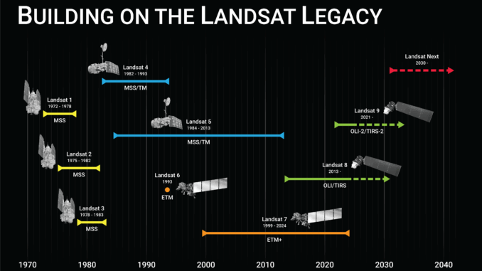
In praise of #Landsat https://gogeomatics.ca/after-landsat-7-honouring-a-legacy-continuing-the-mission/ #earthobservation
J9C :arcgis: :python: :osm: boosted:
MapLibre is at #sotmus this year with two sessions:
📍 June 19, 1 - 2PM, Workshop: Make your own basemap w/ MapLibre + Planetiler (Foundry Shop 6)
📍 June 20, 10:45 - 11AM , State of MapLibre talk (BU Auditorium)
Come say hi!
J9C :arcgis: :python: :osm: boosted:
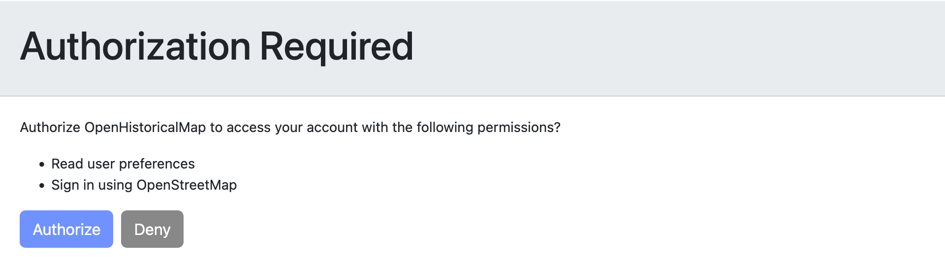
Do you already contribute to @openstreetmap? You can start contributing to OpenHistoricalMap too in just a few clicks, without having to juggle yet another password for yet another mapping site. Once you have a taste of OSM #SingleSignOn via #OAuth2, you’ll never look back.
Client Info
Server: https://mastodon.social
Version: 2025.04
Repository: https://github.com/cyevgeniy/lmst