🚨New article: Disappearing people: A global demographic data crisis threatens public policy
🌍Call for partnerships with LIMCs to co-develop demographic data methods as COVID, loss of trust & funding cuts mean fewer people counted.
#Census #LMIC #CoDevelopment
🔗https://www.worldpop.org/blog/disappearing-people-the-future-of-public-policy-depends-on-co-development-in-demographic-data/
WorldPopProject
Open demographic data for decision making.
📹New video: Professor Andy Tatem speaking on 'Small area population estimation and mapping'
👨👨👧👦 #PopulationData
🗺️ #GeospatialData
📊 #PopulationEstimation
🏫 #CapacityBuilding
🤝 #CoDevelopment
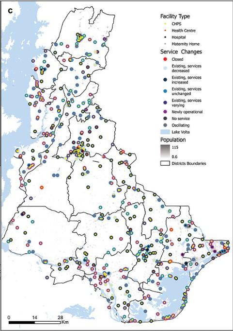
🚨New research paper: Spatio-temporal patterns of #health service delivery and access to maternal, child, and outpatient healthcare in #Volta region, #Ghana
A new approach to monitoring service changes using #HealthData & #SpatialAnalysis - led by Dr Winfred Dotse-Gborgbortsi
➡️ Our new high-resolution population & #vaccination maps show nearly 1 million West & Central African children unvaccinated.
Reach the Unreached project - funded by #UNICEF - working with in-country stakeholders, #CartONG and #MapAction

📣 Listen to Professor Andy Tatem to find out how WorldPop is changing lives and improving decision making in low- and middle-income countries in #TheWeSociety podcast from @acadsocsciences.bsky.social & #WillHutton
🔗https://www.worldpop.org/blog/the-we-society-population-data-destiny
👉 See how our innovative #AI and cutting edge data methodologies help improve child vaccination coverage data
Reach the Unreached project - funded by #UNICEF - working with in-country stakeholders, #CartONG and #MapAction
Listen to Professor Andy Tatem on #BBC Tech Life talk about how WorldPop use Google Open Building Data https://www.worldpop.org/blog/how-worldpop-uses-google-open-building-data/
#PopulationModelling #HealthInterventions #DisasterManagement #CensusPlanning #BBCSounds

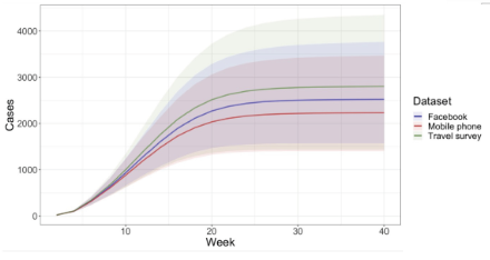
🚨 New research paper: Comparing and integrating human #mobility data sources for #measles transmission modeling in #Zambia https://doi.org/10.1371/journal.pgph.0003906
📊 Integrating multiple data sets improves validity of mobility estimates & dynamics of infectious disease transmission.
✒️ Co-authored by Prof Andrew Tatem, Dr Shengjie Lai and Qianwen Duan
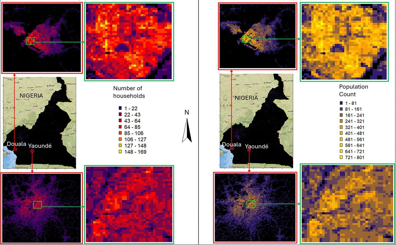
🌍 New preprint available on census-independent small area estimates of population & number of households in Cameroon: doi.org/10.12688/verixiv.933.1
🤝 Collab.with Institut National de la Statistique du Cameroun, Nnamdi Azikiwe University & University of Southampton, led by Dr Chibuzor Christopher Nnanatu. Supported by the Gates Foundation and the UK FCDO.
📂 Datasets: wopr.worldpop.org/?CMR/Population/v1.0
🖥️ R code: github.com/wpgp/Efficient-Population-Modelling-using-INLA-SPDE
📣Beta test our new global #population #data - 2015 to 2030
⬇️Now freely available to download ⬇️
https://www.worldpop.org/blog/beta-test-our-new-global-population-data-2015-to-2030/

Wed 30 Apr 13:00 CAT (UTC+2) join Senior Enterprise Fellow @heatherchamberlain.bsky.social speaking on how high resolution mapped #PopulationData support health programme planning
With the #Zambia #Climate Change #Sustainability & #Health Network
https://zambiaccsnetwork.wixsite.com/home/event-details-registration/high-resolution-mapped-population-data-how-can-this-be-used-to-support-health-programme-planning
Zoom 🔗 https://us02web.zoom.us/j/81601075758?pwd=YSiWCRuJ3JEMaqgfaam7Ybl0r0N3pI.1
🚨New research: Subnational variations in the quality of household survey data in sub-Saharan Africa
Easy-to-access geospatial estimates of survey data quality highlight the need to invest in better targeting of household surveys in remote areas.
Nature Communications 🔗 https://doi.org/10.1038/s41467-025-58776-5

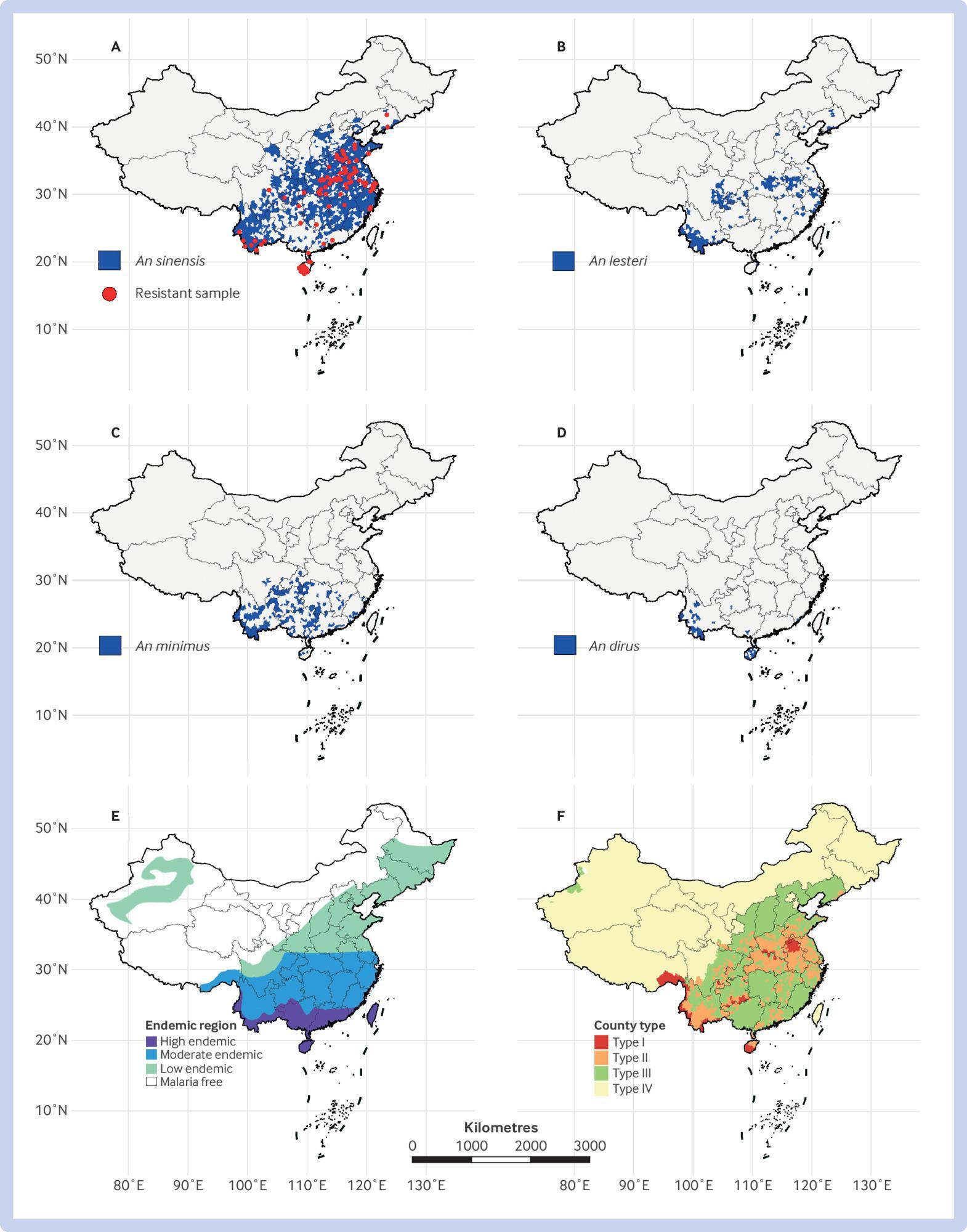
🚨New study: Stratified sustainable vector control strategies & measures for #malaria control & elimination in #China
China’s 70 year endeavour to control vectors for malaria elimination nationwide.
In BMJ 🔗 https://doi.org/10.1136/bmj-2024-080656
Also: Lessons from failure to success on malaria elimination in the Huai River Basin in China
🚨 New project: Machine learning for blue line tracing and wastewater surveillance
🚀We're partnering with @UVA_ID, @imperialmed.bsky.social @novelt_CH @icddr_b and WHO GIS Centre to create smarter, scalable ways to track infectious diseases in low and middle-income countries using #EnvironmentalData #SatelliteData
#Bangladesh 🇧🇩 #Dhaka
https://www.worldpop.org/current-projects/machine-learning-for-blue-line-tracing-and-wastewater-surveillance/
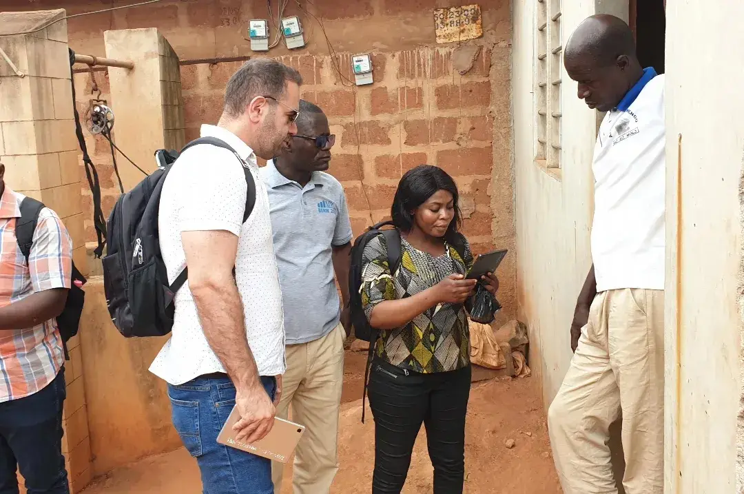
🚀 In preparation for the Somali census, we just wrapped up an intense 8-day "Training the Trainers" workshop! 🌍 The goal? To supercharge the geospatial skills of the Somalia National Bureau of Statistics and #UNFPA Somalia teams. This workshop will play a key role in enhancing the accuracy and efficiency of the upcoming census—critical work for shaping Somalia’s future! 💡
#GeospatialTech #CensusPreparation #SNBS #UNFPA #CapacityBuilding #SomaliCensus #preEA
New research on caesarean services in #Dakar
While most women are <5 min from services, 44.3% bypassed them. Improving health centre's quality & capacity is essential to reduce unnecessary bypassing and ensure timely access to essential obstetric services.
Paper led by Dr El Hadji Malick Sylla with WorldPop's Dr Winfred Dotse-Gborgbortsi.
#Africa #Senegal #WomensHealth
tinyurl.com/ypz8t9cx

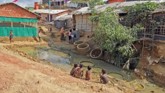
Using satellite imagery and advanced spatial modelling we are collaborating with #UNHCR to innovate mapping of displaced populations and unlocking the power of registration data.
By WorldPop data scientist Edith Darin and others.
We're now on BlueSky! 🦋
👍 Follow us @worldpop-uos.bsky.social 💙

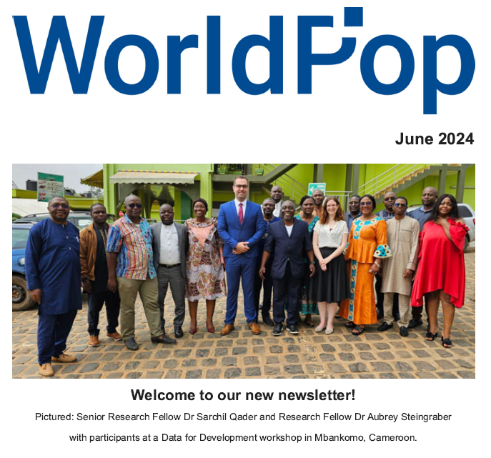
🚨The June edition of our newsletter is now available to download.
#Population #Geospatial #OpenData #Research #Codevelopment #Training #preEATool
🌏 New WorldPop paper on optimizing the detection of emerging infections using mobility-based spatial sampling:
Identifying counter-urbanisation using Facebook's user count data
https://doi.org/10.1016/j.habitatint.2024.103113
Using mobile phone data we develop and test mobility-based spatial sampling frameworks to improve detection efficiency for emerging infections.

Client Info
Server: https://mastodon.social
Version: 2025.04
Repository: https://github.com/cyevgeniy/lmst