Florian Ledermann

Researching & teaching interactive maps at TU Wien (Vienna / Austria / EU)

Critical Engineer 🛠 Cartographer 🗺 Programmer 💻

Striving to go #vegan, you can try too! 🌱💪

Florian Ledermann boosted:
2025-06-24

Mastodon ist jetzt offiziell „Digital Public Good“ – also digitales öffentliches Gut – und steht damit auf einer UN-Liste neben Projekten wie Wikipedia oder LibreOffice. Das Fediverse bekommt damit Rückenwind als gemeinwohlorientierte Alternative zu Big Tech. Anerkannt wurde Mastodon von der Digital Public Goods Alliance (DPGA), einer Initiative der UN. Die Kriterien: Open Source, Datenschutz, kein Konzerninteresse. Für alle, die digital unabhängig und demokratisch kommunizieren wollen, ist das ein starkes Signal.

#Mastodon #Fediverse #DigitalPublicGood #UN #DigitaleDemokratie #BigTechAlternativen

blog.campact.de/2025/06/mastod

2025-05-19

@neocarto Apologies, I am not the admin for that group but I inquired with them!

2025-05-03

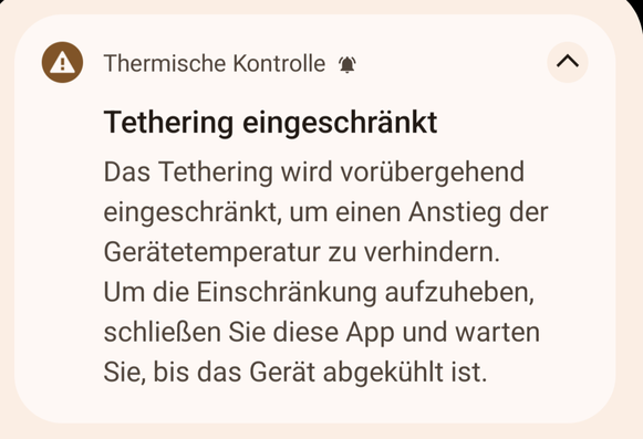
Just encountered a new kind of error message on my phone 😬🥵

"Thethering switched off due to high device temperature"

I guess it is time to move the phone into the shade when working on the patio... 🤷‍♀️

Notification on my phone, saying (translated from German to English):
Thermal Control.
Tethering Restricted.
Tethering is temporarily restricted to prevent the device's temperature from rising. To remove the restriction, close this app and wait for the device to cool down.
Florian Ledermann boosted:
2025-04-30

@floledermann Worth noting that using CSV can also allow extracting a much bigger dataset. For instance with "out center" it's possible to get a CSV extract of all shops (shop=*) in the USA 🇺🇸

2025-04-30

@neocarto
Hi, we are running this Google group / mailing list, which is rather quiet at the moment. But it would be the place where new activities are announced.
groups.google.com/g/icaviz/

2025-04-30

Today I learned that you can export CSV directly from Overpass, *and* you can query features that are within a given polygon relation (not just bounding box).

So my multi-step process to extract cities in Austria from OSM just got reduced to a single #Overpass query 🎉

#OpenStreetMap

Screenshot of the Overpass API query I am using to extract cities in Austria.
Florian Ledermann boosted:
Dr John A Stevensonvolcan01010@fosstodon.org
2025-04-24

The curse of the Minimum Viable Product:

Once you've made something that basically works, no-one wants to give you time to make it as good as you know it should be.

#agile

Florian Ledermann boosted:
tveskovtveskov
2025-04-14

Ready?

Hey guys! It's me pandora welcome to my unboxing video
Florian Ledermann boosted:
Oliver Blanthornbovine3dom@masto.ai
2025-04-09

This is so cool: visualise 100 million books by ISBN, totally client side using shaders, runs smooth-ish on a phone

phiresky.github.io/blog/2025/v

2025-03-30

I've been toying a bit with using LLM's for generating solutions for simple spatial analysis tasks (clustering etc.).

Oh boy! 😔 This stuff will *cost lives* as it will inevitably be used in real-world applications in contexts that are not robust to bullshitting.

Not to speak of the countless hours wasted by experienced folks to fix the stuff junior "developers" come up with.

Productivity boost my a**. This will cause maintenance/debugging/cleanup work of unprecedented scale.

#llm #chatgpt

2025-03-27

I am toying with the idea to build a (physical) globe 🌍 myself. Preferably using #QGIS and maybe Inkscape for final touches (or other OS tools).

I would like to design the globe as far as possible in QGIS and then use an appropriate projection to output the lobes. Then glue to a sphere using wallpaper glue etc. - I imagine it difficult to get the labels right.

Surprisingly, I can find few resources on how to approach such a project.

Any pointers or own experience?

#gischat #cartography

Florian Ledermann boosted:
2025-03-19

Great to see the new QGIS map gallery :qgis: 🤩

hub.qgis.org/map-gallery/

#QGIS #Maps #GISChat

Florian Ledermann boosted:
2025-03-19

Die Aufzeichnungen der News-Infographics-Analytics-Maps #NIAM2025 sind online! 16 tolle Vorträge rund um Karten, (Daten-)Journalismus, Daten, Visualisierung:

news-infographics-analytics-ma

Viel Spaß beim Anschauen!

2025-03-17

But whatever, let's use LLMs to perform government tasks! 🥳 🤡

2025-03-17

Stupidity of #ChatGPT, exhibit #1001: I gave the very first assignment in my JavaScript tutorial for absolute beginners to ChatGPT. The task is to create a simple text-based adventure game using only alert(), prompt() and if-statements.

ChatGPT came up with a nicely looking solution – but the room where you need to use a key to exit cannot be reached from the path where you can acquire the key 🥺 .

So next week, my students who never programmed before will already be smarter than the LLM.

Florian Ledermann boosted:
2025-03-13

Just a reminder that the names of your bibtex citations get included in the PDF (both as the link anchor name and in the metadata), so if you name a paper `morons_who_copied_us`, reviewers and readers will be able to see that...

Florian Ledermann boosted:
2025-03-11

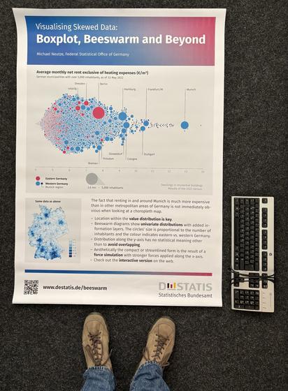
Und das ist das #NTTS2025 Poster. Beeswarm Diagramm der Mieten in Deutschland 2022 für Gemeinden im Vergleich zu einer Karte. #datavis Animation unter destatis.de/beeswarm

DIN A0 Plakat im Größenvergleich zu einer Computer Tastatur und Schuhen der Größe 45. Das Plakat zeigt die Verteilung der Quadratmeter Miete in den Gemeinden Deutschlands aus dem Zensus 2022 mit mehr als 5.000 Einwohnern prominent als Werteverteilung (Beeswarm) und zur regionalen Einordnung zusätzlich als Karte. Die außergewöhnlich teuren Mieten in der Region München werden im Beeswarm deutlicher als in  einer Choroplethenkarte.
Florian Ledermann boosted:

the thing i hate most about tech is that it often doesnt allow solved problems to remain solved.

i want permacomputing stuff. i want a computer like a cast iron pan. needs its care yes but its not much and not often.

Florian Ledermann boosted:
2025-02-18

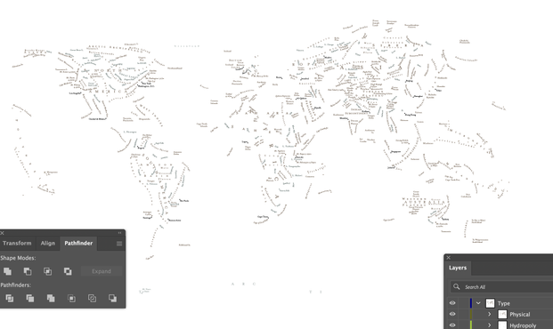
About 450 labels in place so far. Mostly just maritime things left to do. I may never tire of seeing #maps with all layers turned off except the labels.

A world map, showing only labels. All other layers are turned off. A variety of brown and blue labels spell out the names of major land-based features.
2025-02-18

@pinakographos The broken (AN)T-ARC-TI-(CA) label lets me assume this is not the CRS the final map will be shown in?

Client Info

Server: https://mastodon.social
Version: 2025.04
Repository: https://github.com/cyevgeniy/lmst