Very nice GEDI dervived global data. https://meta-forest-monitoring-okw37.projects.earthengine.app/view/canopyheight & https://registry.opendata.aws/dataforgood-fb-forests/ & https://sustainability.fb.com/blog/2024/04/22/using-artificial-intelligence-to-map-the-earths-forests/
Andrew Cutts
Freelancer #EarthObservation #Geospatial #Python will train (http://acgeospatial.co.uk/training/), write and consult for you 😀 http://acgeospatial.co.uk
#eochat :cog: :gearth: :gearth_engine: :gdal: :qgis:
Andrew Cutts boosted:
FINALLY! 📢
Version 10 of ESA's SNAP has been released!
But was it worth the wait? 🤔
Read in my blog what has changed and what has been added in this version.
Andrew Cutts boosted:
I've used GeoPandas for a while and never known about the .cx accessor. You can use it to easily subset by a bounding box - like:
gdf.cx[xmin:xmax, ymin:ymax]
I think that'll be pretty useful! See https://geopandas.org/en/stable/docs/reference/api/geopandas.GeoDataFrame.cx.html for more details
Andrew Cutts boosted:
I've created a new web app - British Placename Mapper at https://placenames.rtwilson.com/ - you can search for placenames in various ways (starts with 'great', ends with 'burgh' etc) and show them on an interactive map. Try a few of the examples and send me any cool maps you come up with!
(Re-posting for those who sensibly weren't using social media on a bank holiday weekend!)
Andrew Cutts boosted:
Radar satellites can see at night and through clouds
They also can detect millimetre changes in some cases, from space (!)
But I've found them really counter-intuitive, so I spent the last 6 months working on a video explaining how they work
Watch: https://youtu.be/zMsCyEAOrh0
Andrew Cutts boosted:
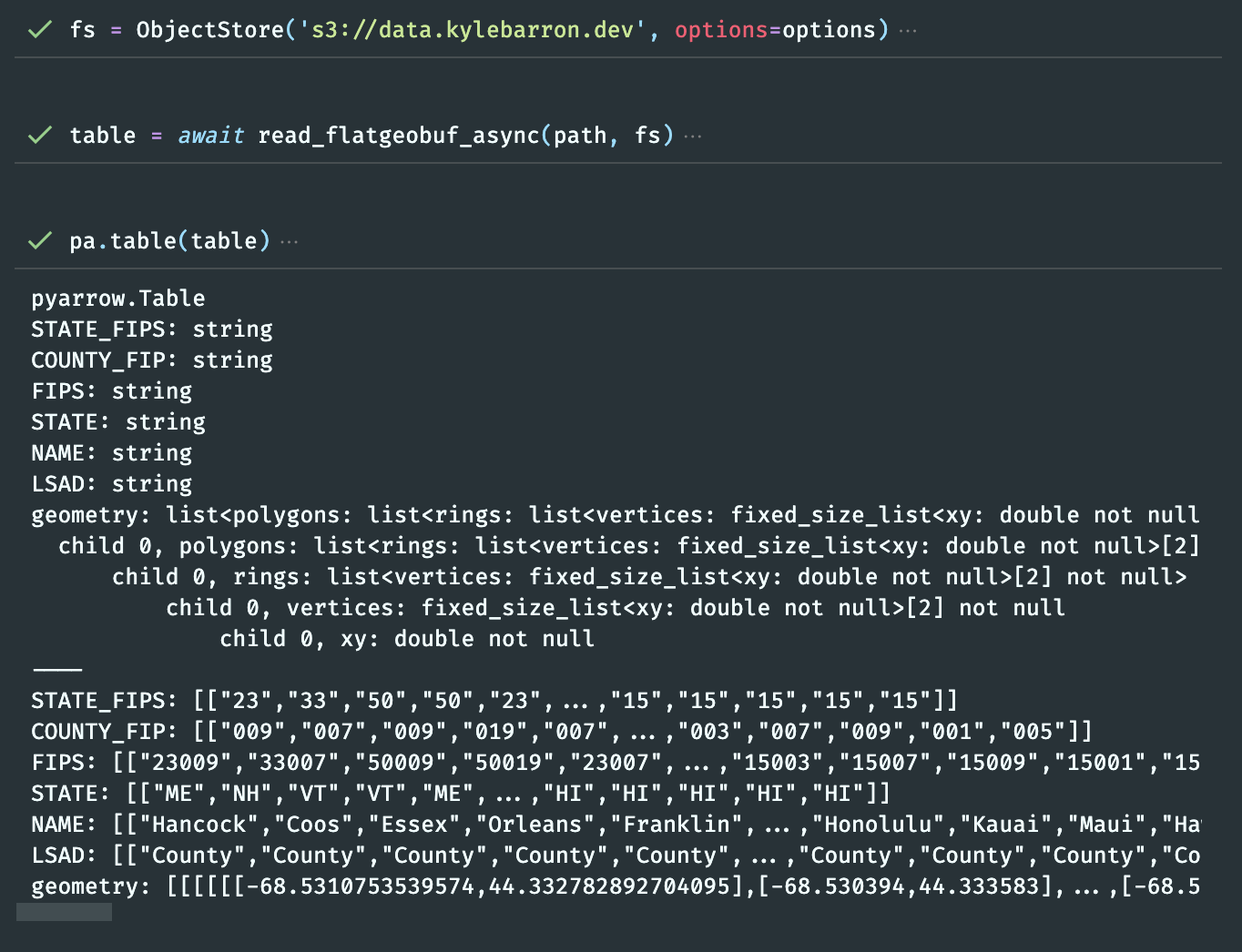
Got an async FlatGeobuf reader working in Python tonight (with s3, gcs, azure support) via geoarrow-rust!
This will support bounding-box queries as well, directly from remote files.
Andrew Cutts boosted:
Welcome to :qgis: 3.36 Maidenhead!
https://youtube.com/watch?v=WS9W1fo9Aso
#QGIS
@walkermatt Thank you!
Andrew Cutts boosted:
Interested in or want to learn #GIS? Grab 30% off my GIS: Research Methods book, so only £16.24, from @BloomsburyBooks, available until Sunday (£13.29 +£2.95 postage). Book details & first chapter for #free at https://www.nickbearman.me.uk/gis-research-methods/, order at https://www.bloomsbury.com/uk/gis-9781350129559/ #GISchat
@geojulien Thanks for reading. Yes that is an option, I think this sums up that https://www.bostongis.com/blog/index.php?/archives/271-New-in-QGIS-3.2-Save-Project-to-PostgreSQL.html In my case (for the client I worked for) we didn't have PostgreSQL and this was a 'simple' solution.
New blog post. 'Managing a master #QGIS project (with a .bat file)'. Use a master project, but not change it. Give a copy to each person on the desktop with a .bat file http://www.acgeospatial.co.uk/managing-a-master-qgis-project-with-a-bat-file/
Andrew Cutts boosted:
📢 OGC is seeking public comment on the adoption of openEO as a Community Standard. openEO aims to increase the interoperability of processing “big EO data” (e.g. satellite imagery) in the cloud by defining a simple an unified API.
https://bit.ly/49pZaDE
#OGC #standard #EarthObservation #openEO
Andrew Cutts boosted:
Search and acquire any satellite images with just a few lines of code in R!
Notebook available here: https://gist.github.com/kadyb/31799be3a639910efac6095ef9d4c665
Andrew Cutts boosted:
Happy 18th birthday, @osgeo - continue to support and promote the collaborative development of open geospatial technologies and data!
https://neteler.org/blog/celebrating-18-years-of-the-open-source-geospatial-foundation-osgeo/

Andrew Cutts boosted:
Finding Geospatial Accounts on Mastodon
Besides following hashtags, such as #GISChat, #QGIS, #FOSS4G, #openstreetmap and #OSGeo, curating good lists is probably the best way to stay up to date with geospatial developments. To get you started (or to potentially enrich your existing lists), I thought I'd share my #Geospatial and #SpatialDataScience lists with you.
http://anitagraser.com/2024/02/03/finding-geospatial-accounts-on-mastodon/
Andrew Cutts boosted:
Introducing lonboard: the fastest way to visualize large geospatial vector data from Python.
Here's 3 million points rendered with a unique color and radius per point, in two seconds.
https://developmentseed.org/blog/2023-10-23-lonboard
https://ds.io/lonboard
Andrew Cutts boosted:
Segment-geospatial v0.9.0 is out📢It now supports segmenting remote sensing imagery with box prompts. You can create box prompts interactively or use existing vector data as box prompts 🌐
GitHub: https://github.com/opengeos/segment-geospatial
Notebook: https://samgeo.gishub.org/examples/box_prompts
Video tutorial: https://youtu.be/ayFgAj23BfI
Andrew Cutts boosted:
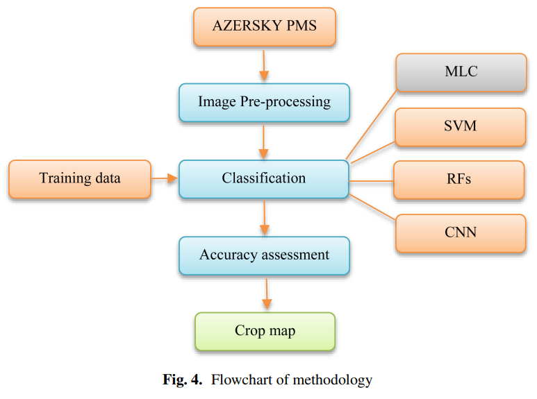
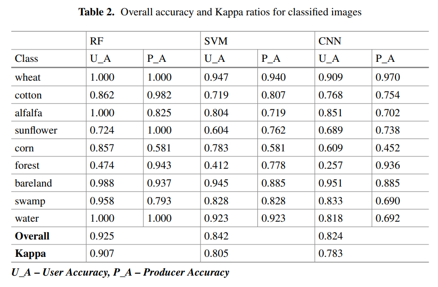
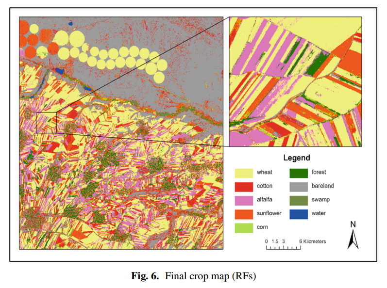
@sonaguliyeva et al. (2023) applied #machinelearning algorithms in mapping #croptypes using high resolution #Azersky imagery & demonstrated the value of #opensource platforms like #GoogleEarthEngine in the #classification of crops #LoLManuscriptMonday https://bit.ly/Guliyeva_2023
Shout out to Sona's co-authors & affiliated organizations #Azercosmos #NationalAviationAcademy #Azerbaijan #EOChat #GISChat
Andrew Cutts boosted:
Hosting platforms for python
#Python
https://www.python-engineer.com/posts/hosting-platforms-for-python/
Andrew Cutts boosted:
Jupyter + Quarto = easy scientific and technical publishing!
At #JupyterCon, J.J. Allaire shared how the two work together to easily create and share the output format (HTML, PDF, Microsoft Word, reveal.js) and the styling you need for any situation.
There are so many features that make scientific and technical publishing an actual joy. Check out his talk to hear more! #Python #Quarto
Client Info
Server: https://mastodon.social
Version: 2025.04
Repository: https://github.com/cyevgeniy/lmst