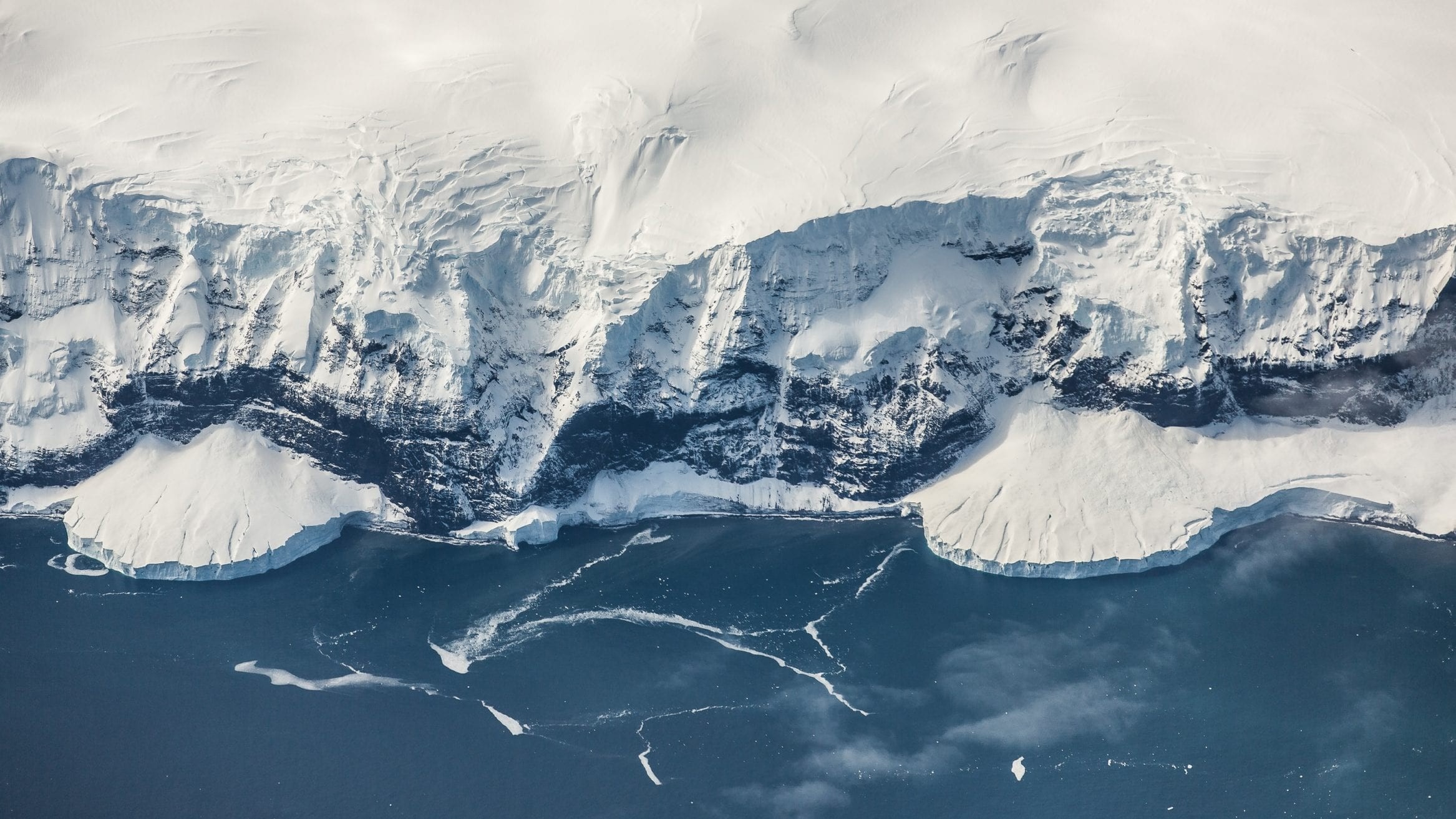
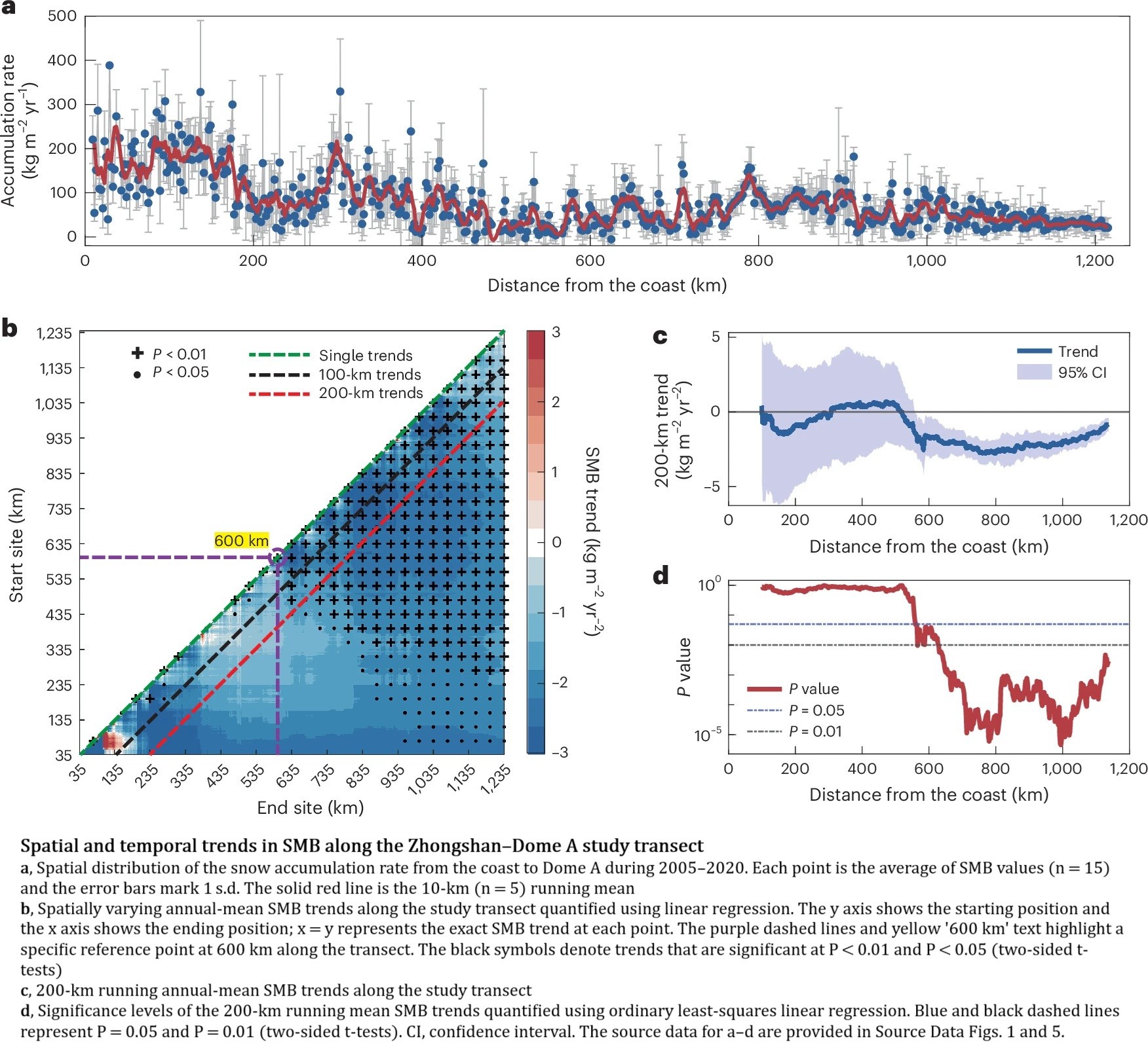
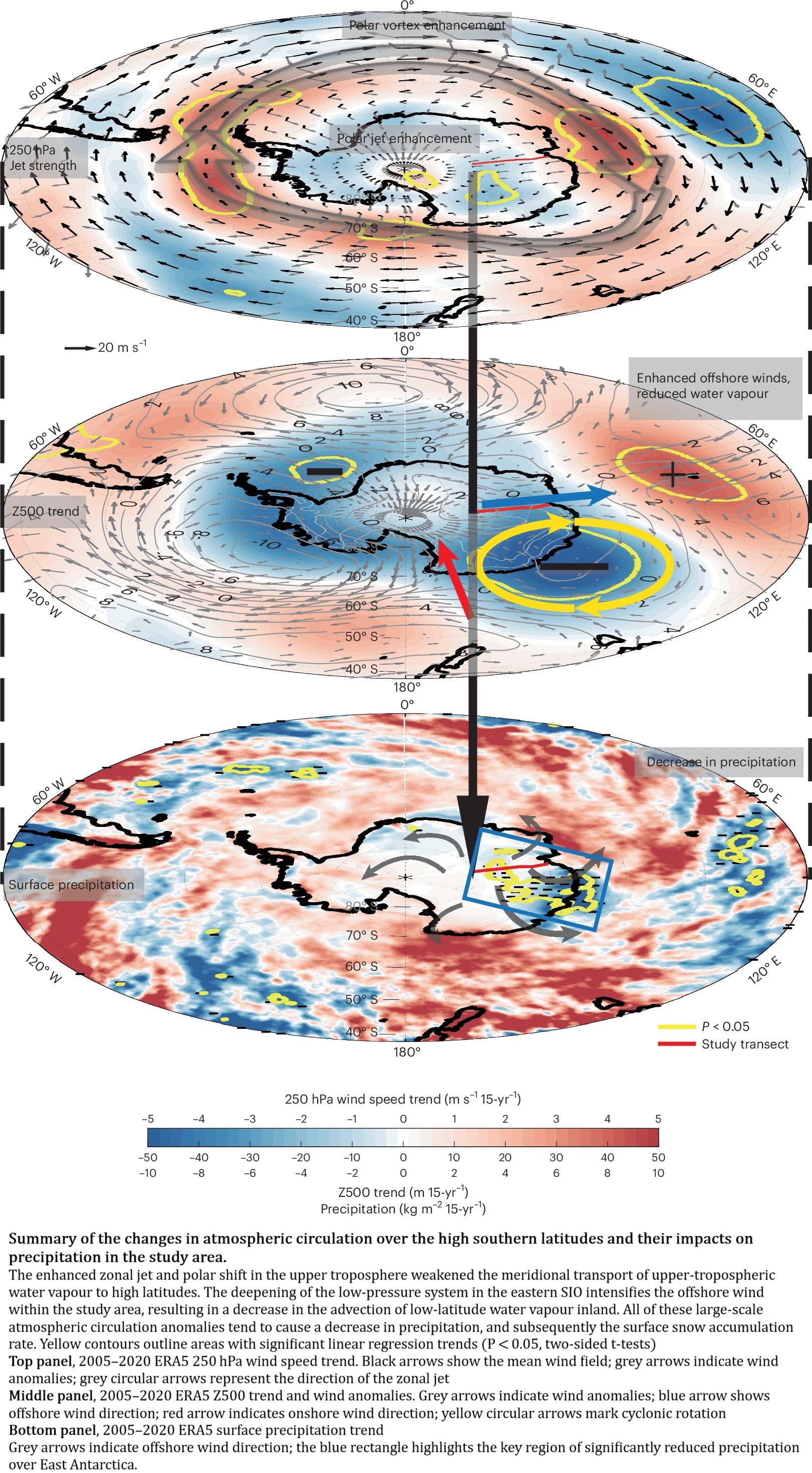
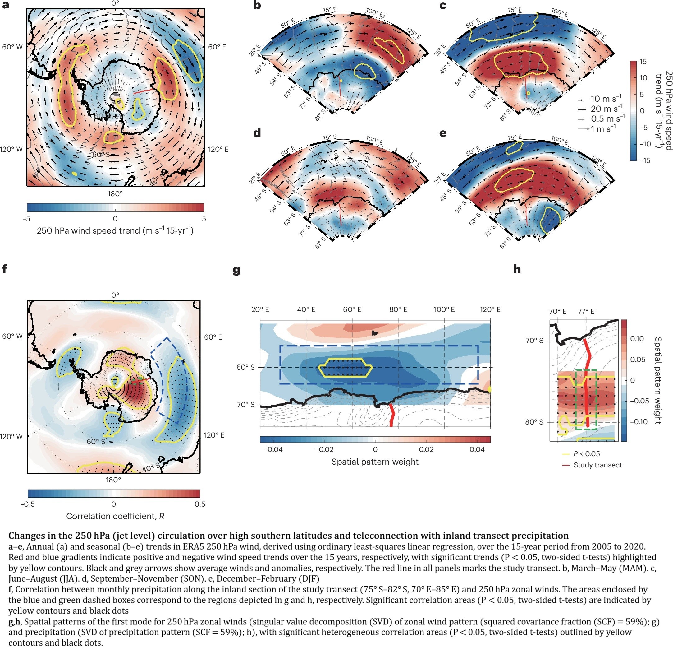
Sustained Decrease In Inland East Antarctic Surface Mass Balance Between 2005 And 2020
--
https://doi.org/10.1038/s41561-025-01699-z <-- shared paper
--
#GIS #spatial #mapping #Antarctic #EastAntarctic #icesheet #massbalance #spatialanalysis #model #modeling #spatiotemporal #water #climate #climatedynamics #monitoring #remotesensing #earthobservation #icecore #snowpit #wind #melting #water #ice #science #cryology #snow #weather #watervapour #climatemodel
#EarthObservation
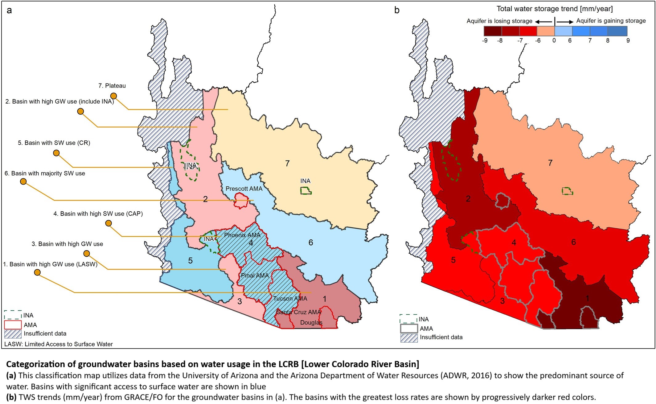
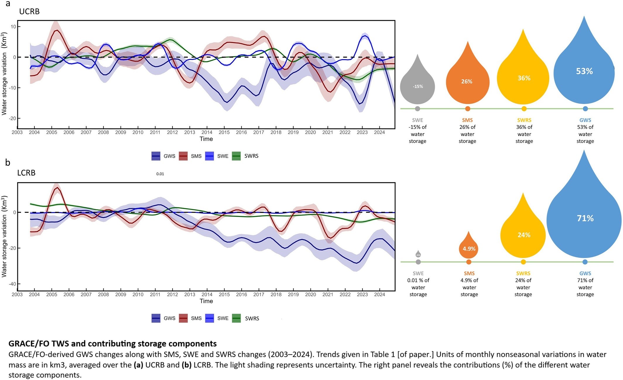
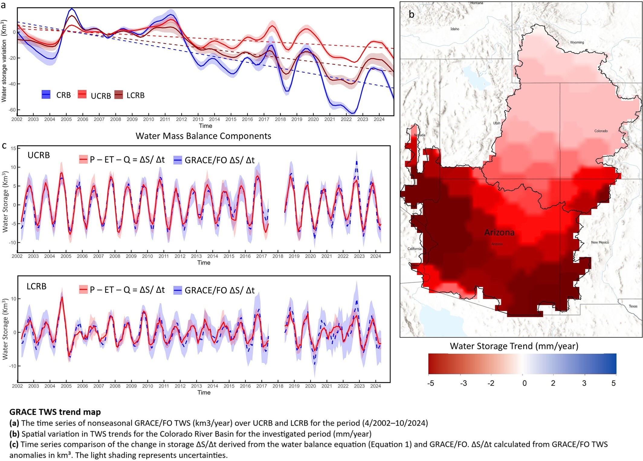
Declining Freshwater Availability in the Colorado River Basin Threatens Sustainability of Its Critical Groundwater Supplies
--
https://doi.org/10.1029/2025GL115593 <-- shared paper
--
https://www.livescience.com/planet-earth/rivers-oceans/groundwater-in-the-colorado-river-basin-wont-run-out-but-eventually-we-wont-be-able-to-get-at-it-scientists-warn <-- shared technical overview article
--
#GIS #spatial #mapping #water #hydrology #groundwater #waterresources #management #planning #ColoradoRiver #ColoradoRiverBasin #depletion #pumping #overpumping #climatechange #extremeweather #droughts #watershortage #waterstorage #remotesensing #spatialanalysis #earthobservation #satellite #spatiotemporal #GRACE #GRACEFO #model #modeling #sustainable #extraction #research
🌱 Unlocking land insights with Sentinel-2 indices:
Indexes to show vegetation health, water dynamics and drought stress
Pozuelo de Alarcón (Summer 2023) shows how combining NDVI+SAVI+NDMI reveals hidden patterns in urban greenspaces & water resources.
#RemoteSensing #GIS #Environment #SmartCities #EarthObservation #Rstats
What Is OSCAR and How Can Vanuatu Benefit from This Cutting-Edge Climate App?
OSCAR is a global platform developed by the World Meteorological Organization (WMO) that supports better Earth observation and smarter planning for agriculture, climate monitoring, and disaster readiness—right here in Vanuatu | #OSCAR #EarthObservation #ClimateTech #WeatherMonitoring #VanuatuData #WMO #SatelliteData #EnvironmentalPlanning #ClimateChangeVanuatu #TechForGood
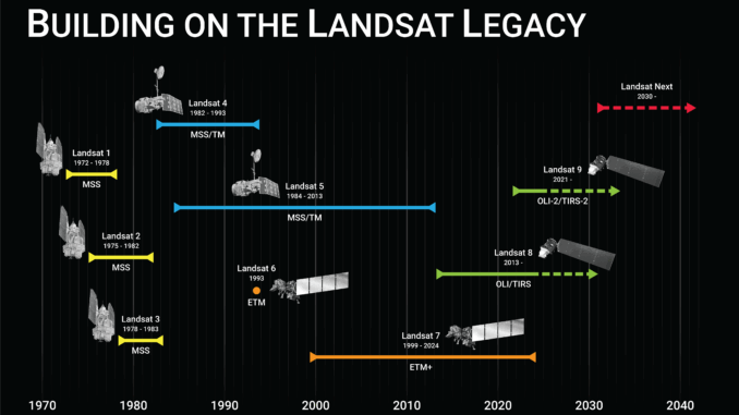
In praise of #Landsat https://gogeomatics.ca/after-landsat-7-honouring-a-legacy-continuing-the-mission/ #earthobservation
🚀 Excited to share our team’s contributions at the ESA Living Planet Symposium next week in Vienna! Catch us across multiple sessions on carbon fluxes, EO data consistency, AI for climate science & more.

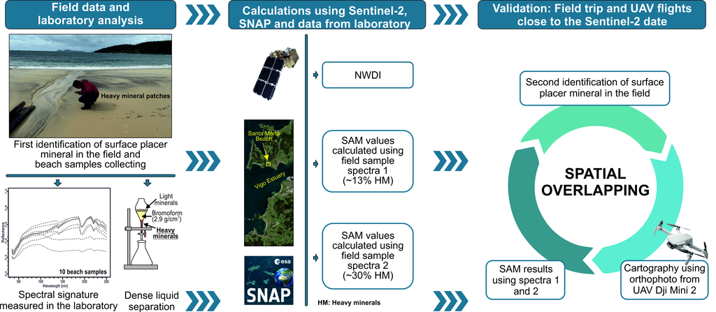
This article shows the usage of SNAP's Spectral Angle Mapper in practice.
https://www.mdpi.com/2072-4292/17/11/1824
SNAP help: https://step.esa.int/main/wp-content/help/?version=12.0.0&helpid=SAMProcessor
#SNAP #ReomteSensing #EarthObservation
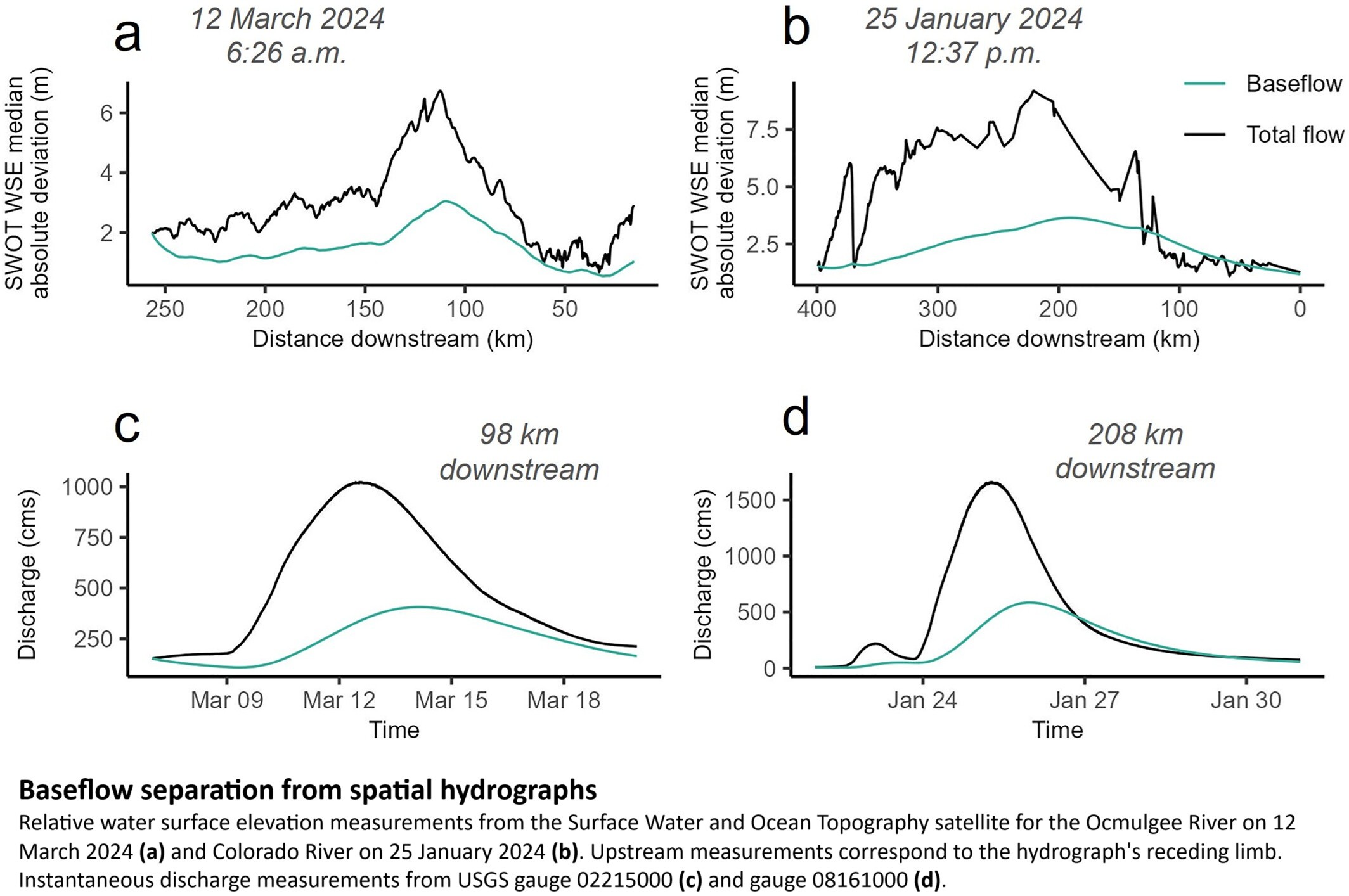
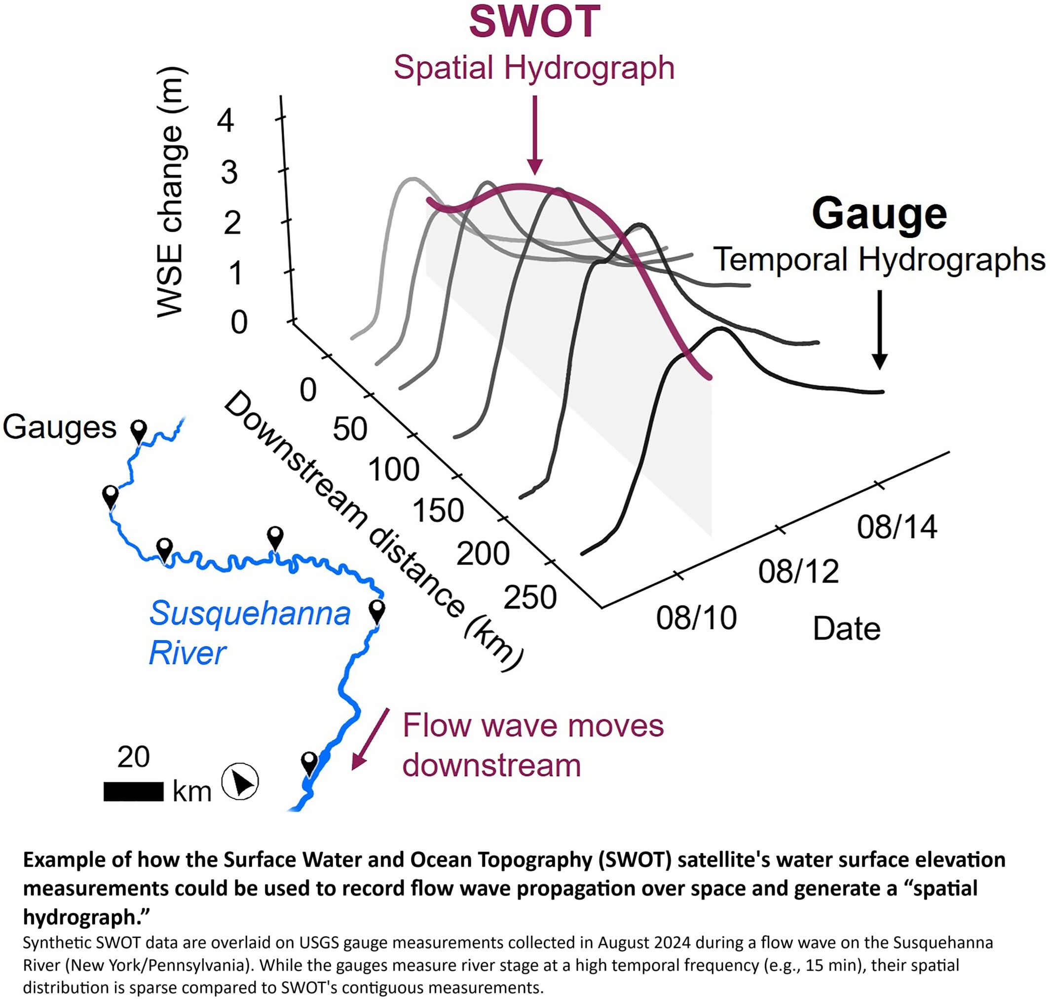
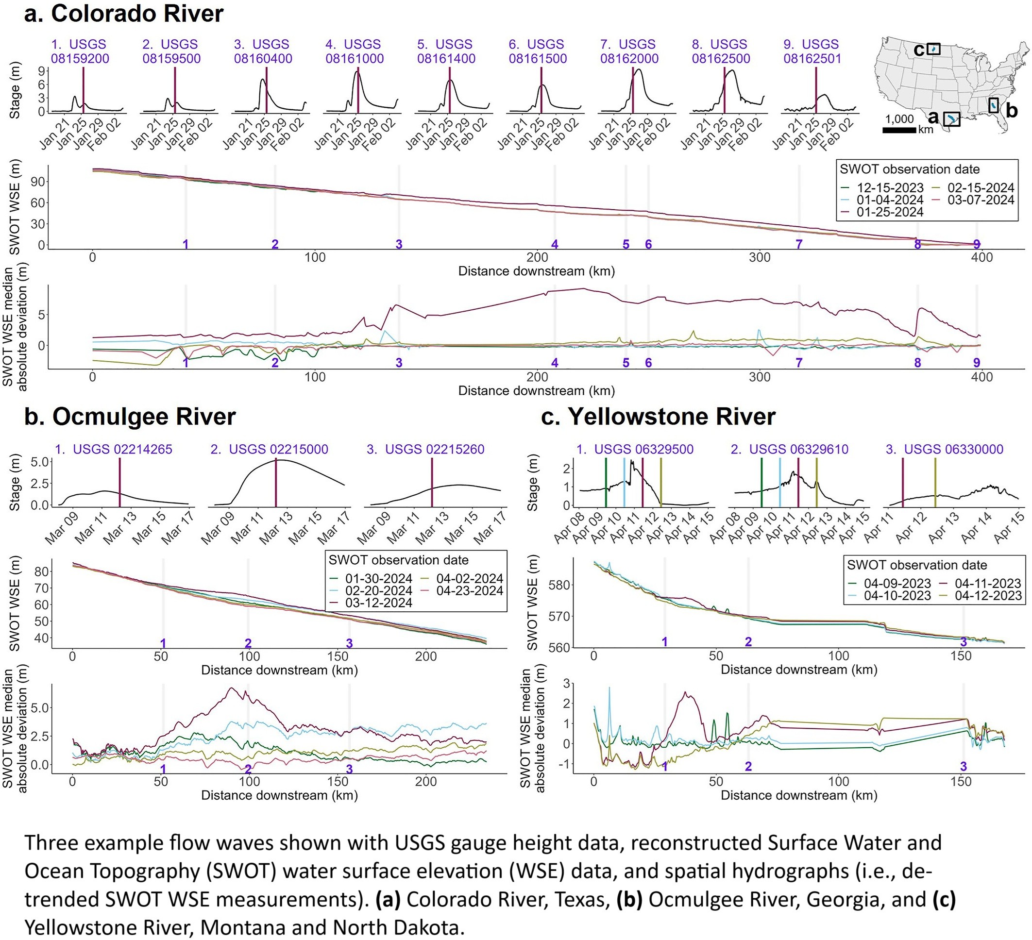
SWOT Captures Hydrologic Waves Traveling Down Rivers
--
https://doi.org/10.1029/2024GL113875 <-- shared paper
--
#GIS #spatial #mapping #model #SWOT #water #hydrology #hydrography #discharge #flowwaves #stream #river #gage #gauge #hydrograph #spatialanalysis #spatiotemporal #baseflow #extremeweather #highflow #remotesensing #earthobservation #satellite
An interview with Dr. Vernon Singroy, a Canadian #SAR #earthobservation hero.
"A lot of what’s now routine in government, crop classification, soil moisture monitoring, ice detection, started as research...."
"...remote sensing has used AI techniques for decades...."
"I don’t think I did anything special. I just loved what I did, and I worked hard at it."
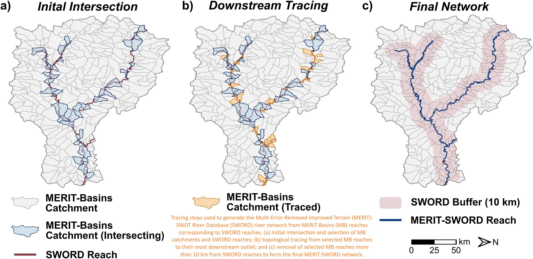
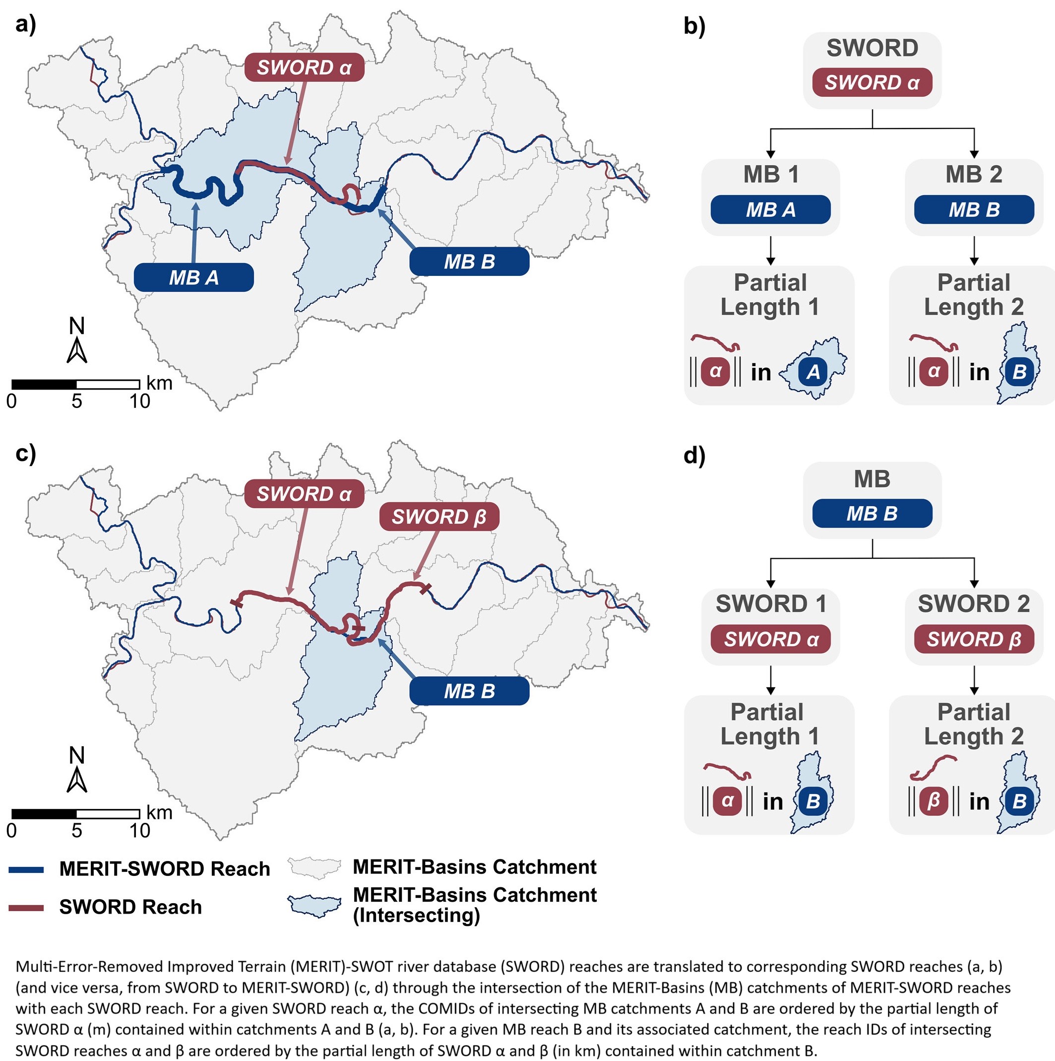
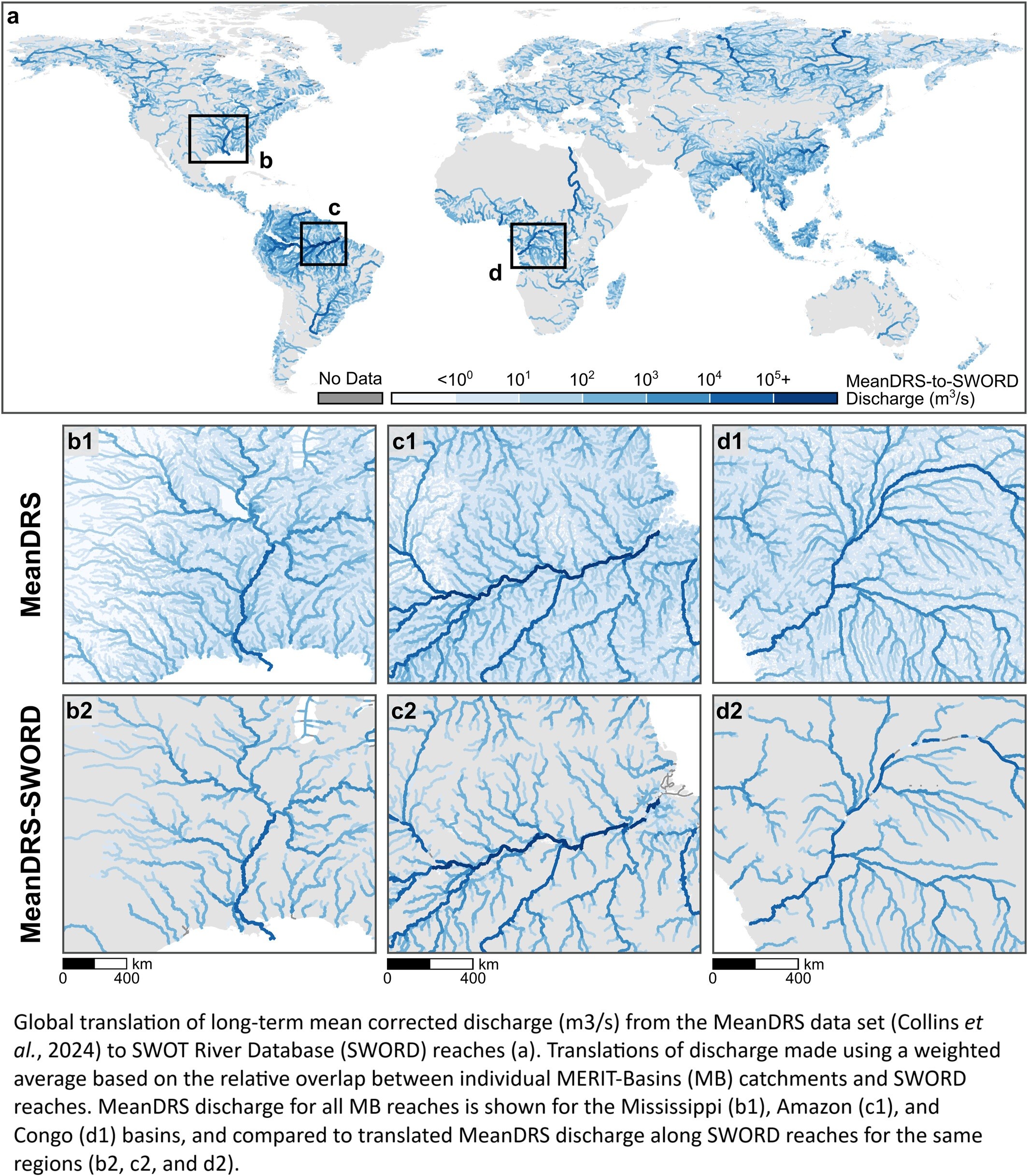
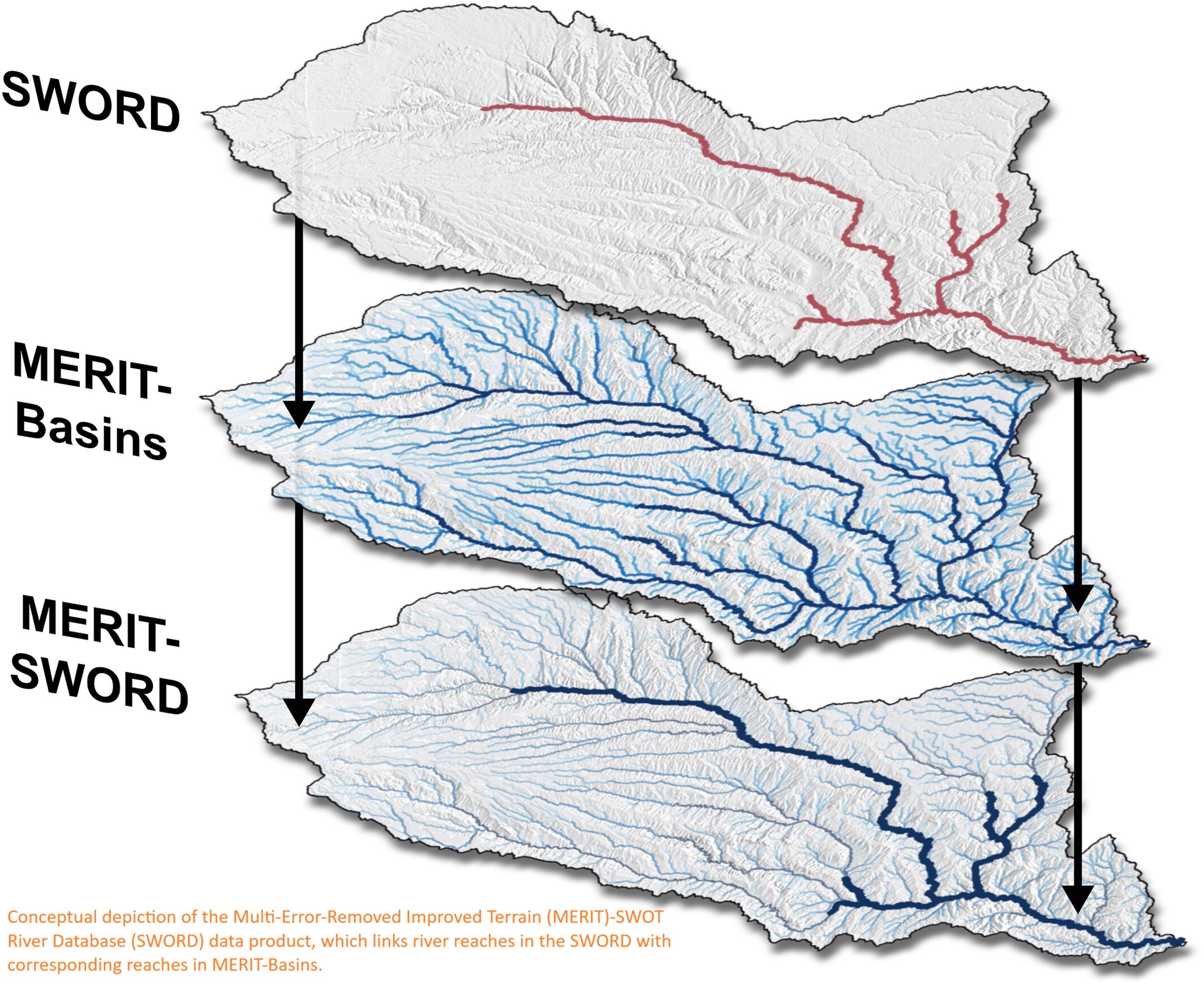
Bidirectional Translations Between Observational And Topography-Based Hydrographic Data Sets - MERIT-Basins And The SWOT River Database (SWORD)
--
https://doi.org/10.1029/2024WR038633 <-- shared paper
--
#GIS #spatial #mapping #water #hydrology #model #modeling #SurfaceWater #Ocean #Topography #SWOT #SWORD #hydrography #stream #river #datasets #MERIT #basin #watershed #inventory #routing #network #discharge #flow #peakflow #remotesensing #satellite #earthobservation
🚀 EO-Tools v2024.6.0 is out!
This update brings minor improvements and fixes:
🛠️ Added a sample EODAG config
🛰️ Orbit directory now configurable per function
📦 Improved and modernized type hints
⬆️ Dependencies upgraded
🔗 https://eo-tools.readthedocs.io/en/latest/
#EOtools #RemoteSensing #Python #Sentinel1 #InSAR #EarthObservation #SyntheticApertureRadar
"While some areas like Eastern Canada have seen net water gains, the overall national trend indicates a steady decline, averaging a loss of 11 millimeters of water per year. In total, #Canada has lost the equivalent of 1.6 times the volume of Lake Ontario in #freshwater contributing to approximately 8.5% of global sea-level rise during that period."
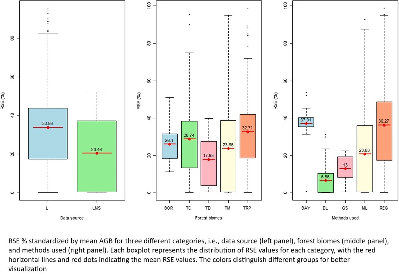
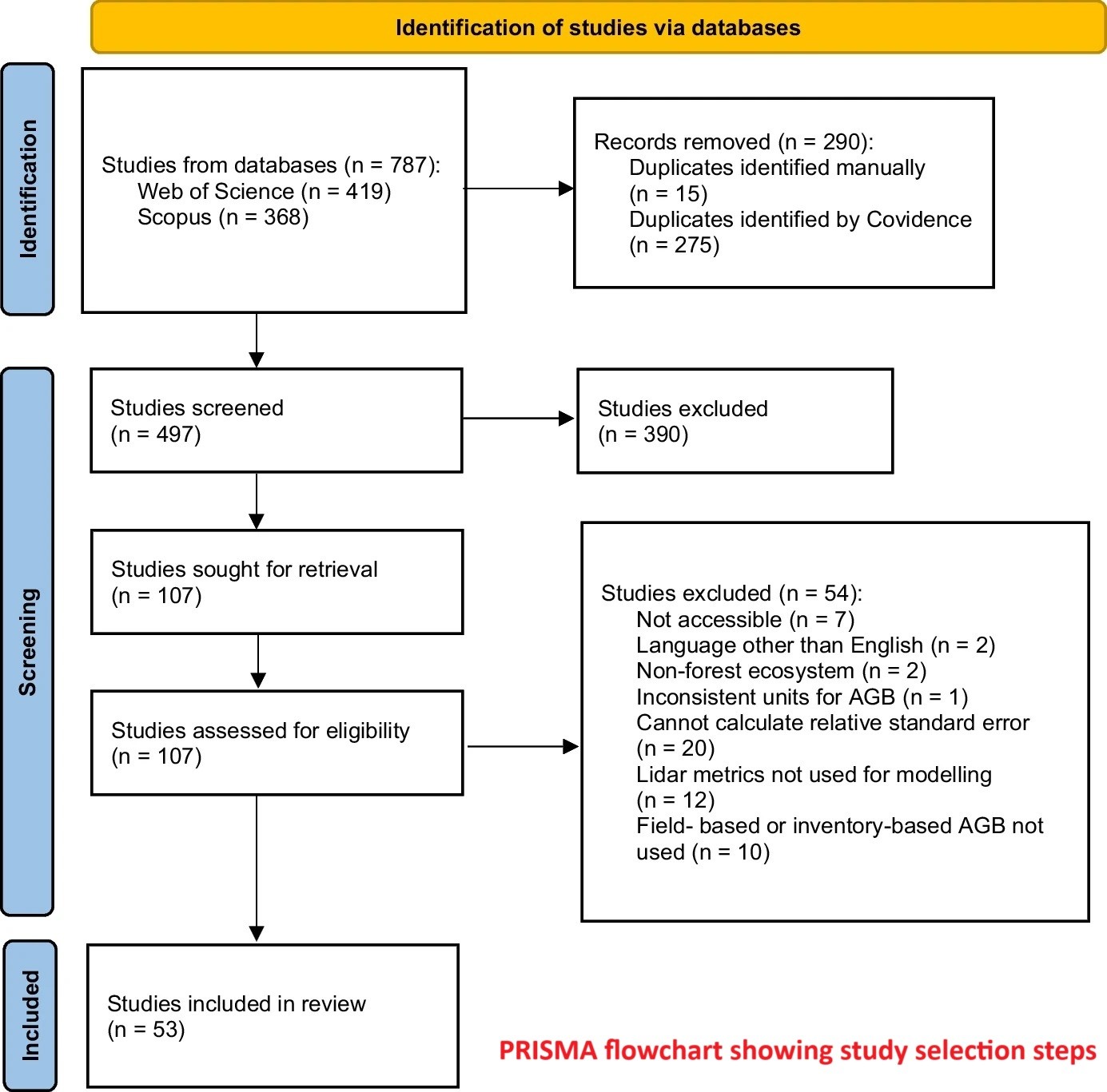
Forest Aboveground Biomass Estimation Using Airborne LiDAR - A Systematic Review And Meta-Analysis
--
https://doi.org/10.1007/s44392-025-00029-w <-- shared paper
--
#GIS #spatial #mapping #remotesensing #earthobservation #LiDAR #forest #vegetation #degradation #biomass #spatialanalysis #spatiotemporal #REDD #research #review #metaanalysis #opendata #AGB #model #modeling #papers #journal #PRISMA #statistics #geostatistics
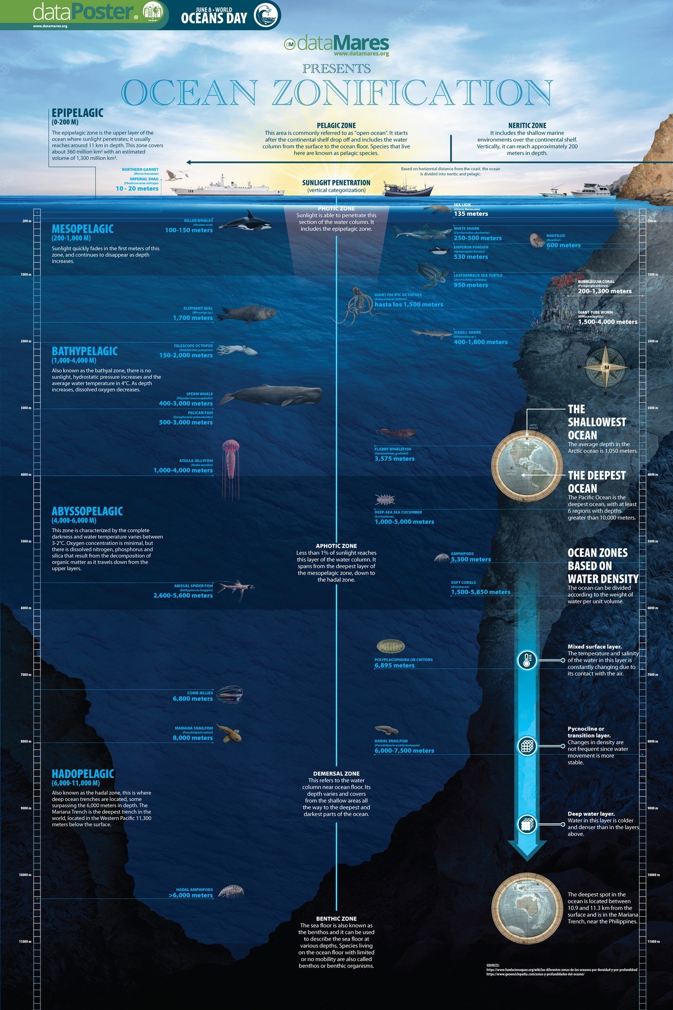
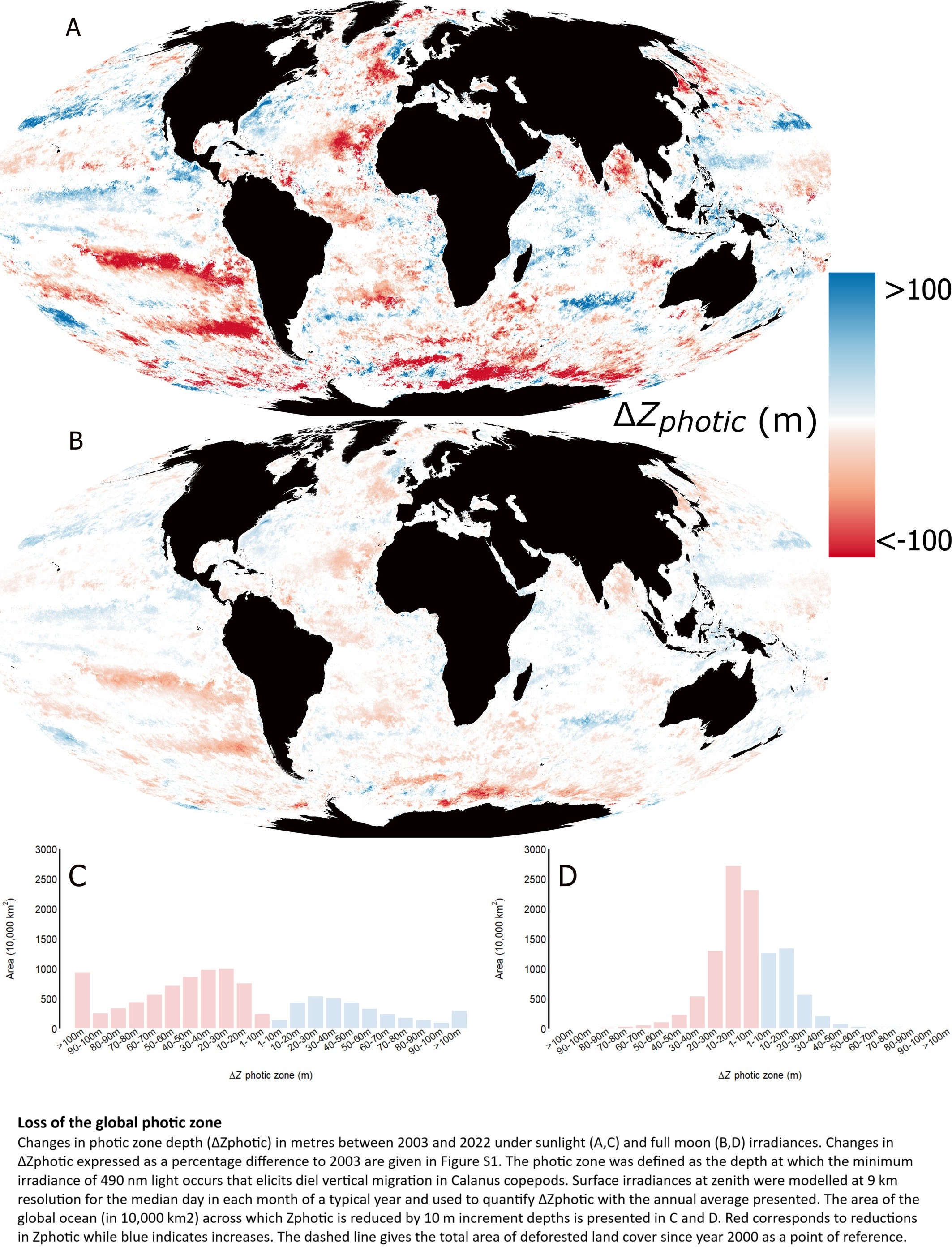
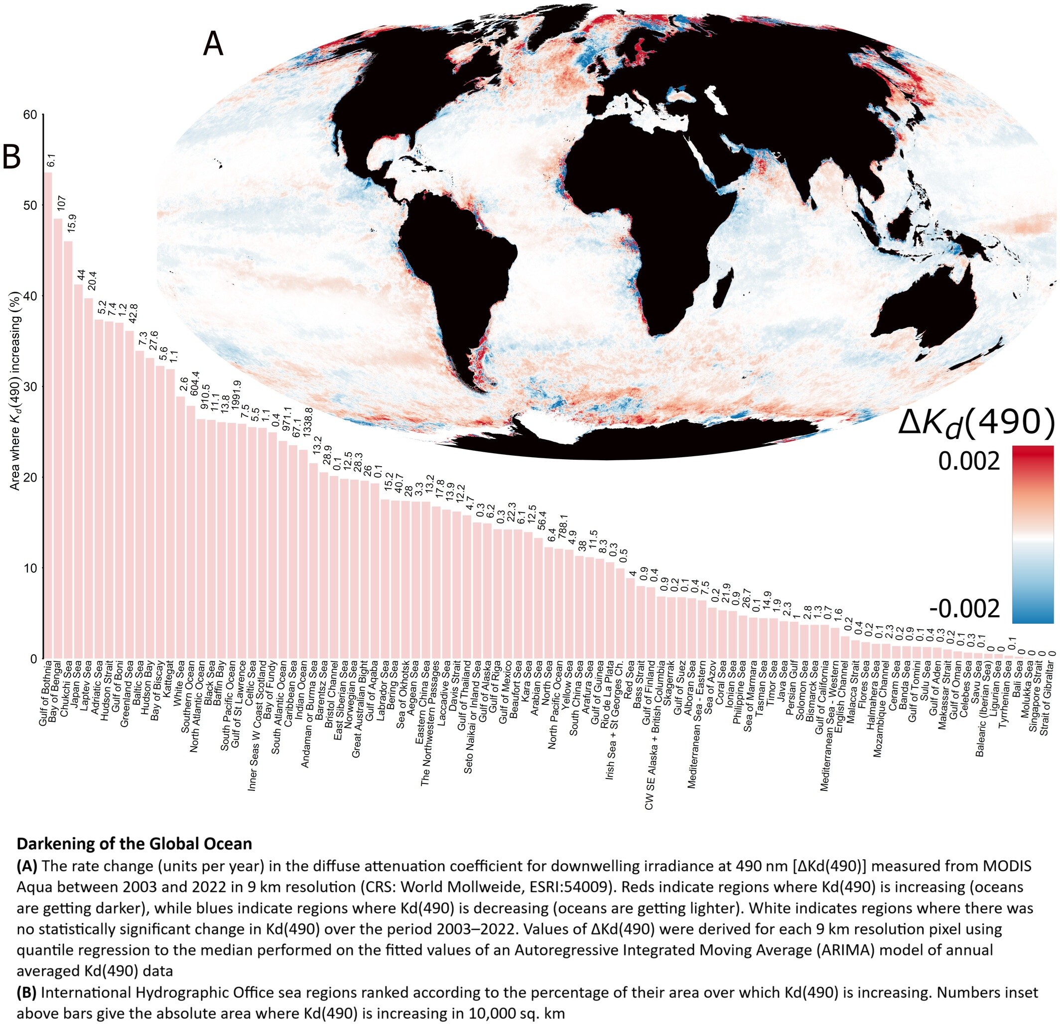
Darkening Of The Global Ocean
--
https://doi.org/10.1111/gcb.70227 <-- shared paper
--
[a little outside of ‘my usual’, but fascinating (and alarming, frankly…)]
#GIS #spatial #mapping #marine #ocean #photic #photiczone #ecology #change #sunlight #moonlight #spatialanalysis #spatiotemporal #darkening #habitat #biogeochemical #penetration #MODIS #remotesensing #earthobservation #satellite #light #coast #deepsea #openocean #nutrient #sediment #currents #circulation #productivity #fisheries #surface #ecology #ecosystems #impacts #humanimpacts
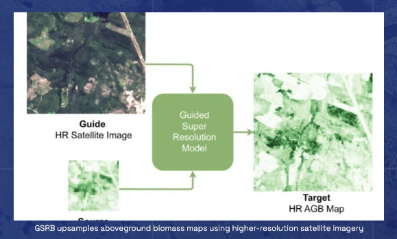
🌿 New research alert from #Embed2Scale ‼️
💡 A new study by our partners at the University of Zurich demonstrates how super-resolution techniques using Sentinel-1 & Sentinel-2 data can significantly enhance existing biomass maps—offering 10m resolution estimates that are both more accurate and less biased.
📄 Read the publication: https://embed2scale.eu/download/gsr4b-biomass-map-super-resolutionwith-sentinel-1-2-guidance/?wpdmdl=1862
#EarthObservation #RemoteSensing #Biomass #Sentinel #AI4EO #Copernicus #SuperResolution #GeospatialAI #ClimateData
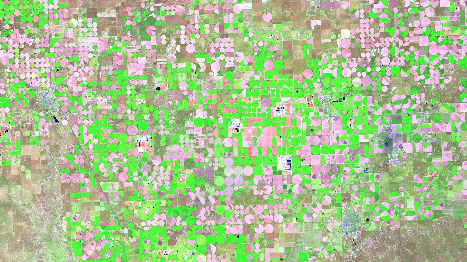
Satellite Image of the Month – June 2025: Take a look at the stunning circular fields near Dalhart, Texas! This vibrant false-color image, captured by Sentinel 2, reveals the impact of center-pivot irrigation in one of the most productive farming regions of the U.S. High Plains.
👉 Read more: https://www.mundialis.de/en/satellite-image-of-the-month-june-dalhart-texas-usa/
#SatelliteImagery #RemoteSensing #Texas #Copernicus #Agriculture #EarthObservation #Sentinel2
The Trump regime's attack on #climate science and #earthobservation. "Unnecessary climate measurements rather than weather observations" The drivel is painful to read. Also, rovers on #Mars are collecting samples for nothing. Sorry, Curiosity and Perserverance.
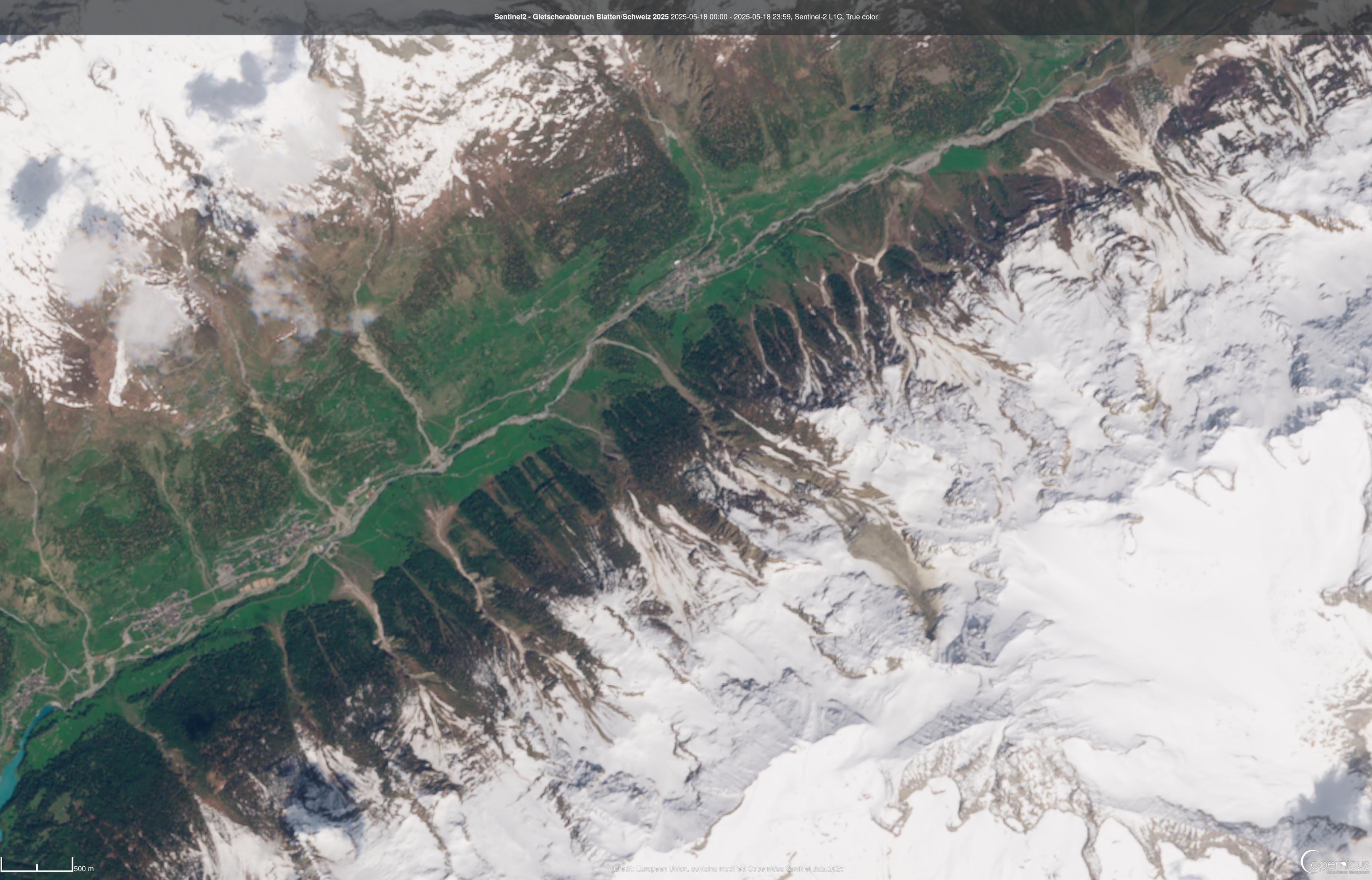
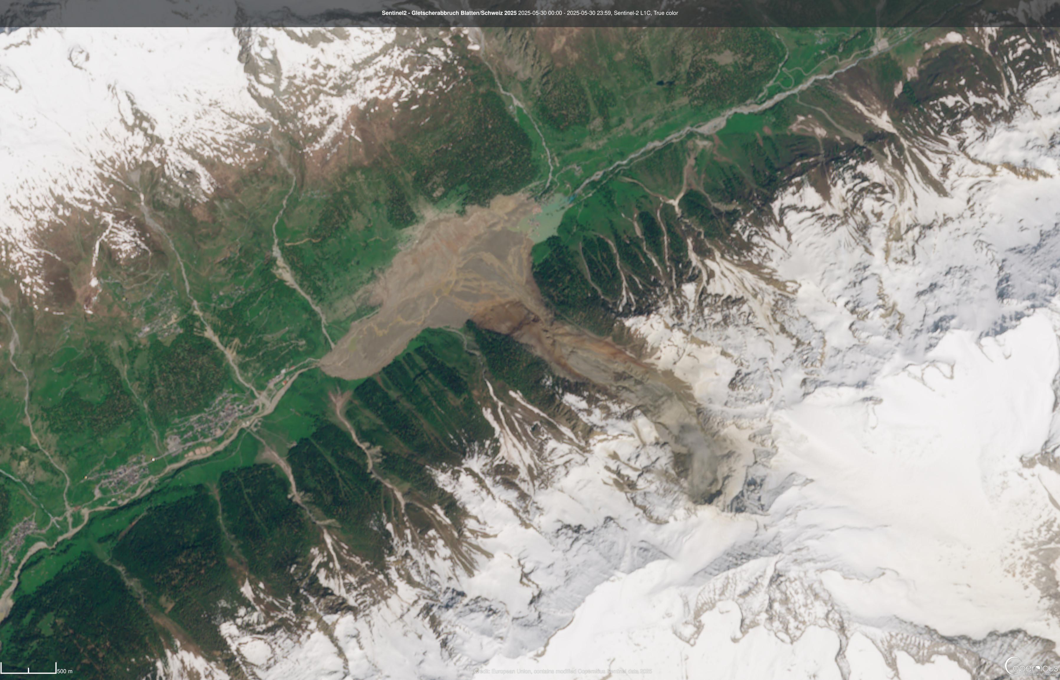
Before/after image from the Sentinel-2 satellite of the glacier collapse near Blatten in Switzerland.
Before image is from 18.05.2025
After image is from 30.05.2025
#sentinel #sentinel2 #copernicus #EarthObservation #swiss #glacier #glaciercollapse
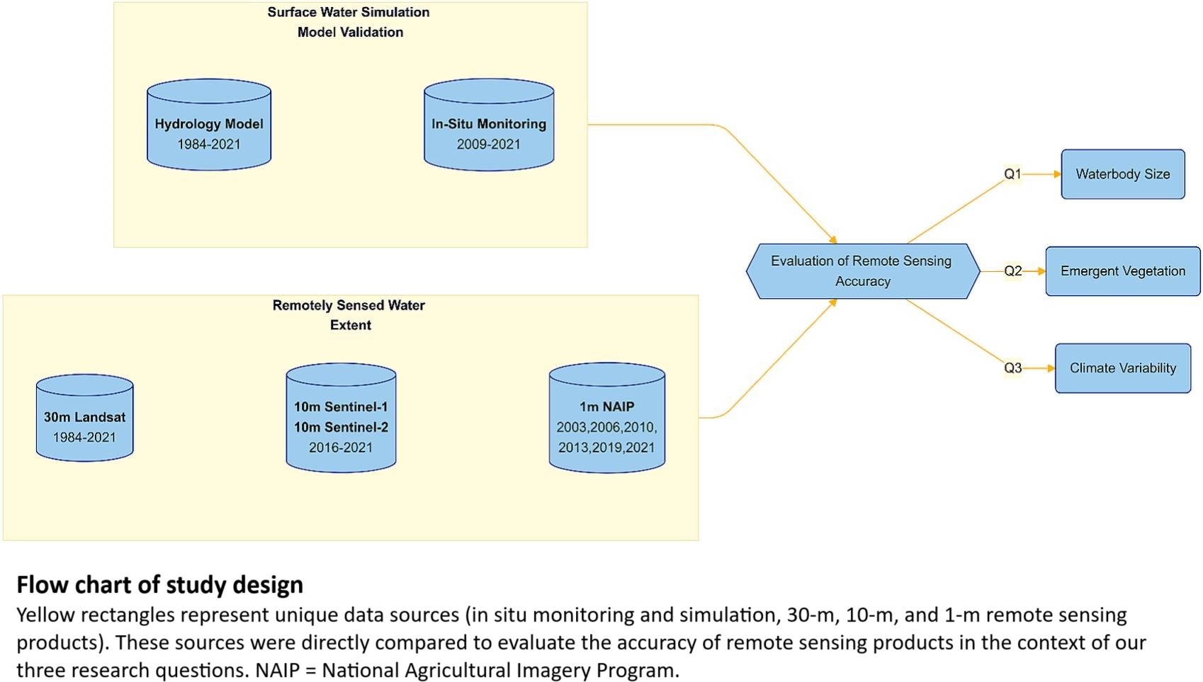
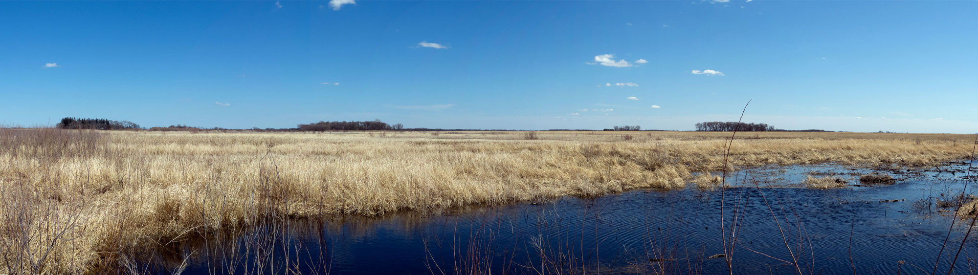
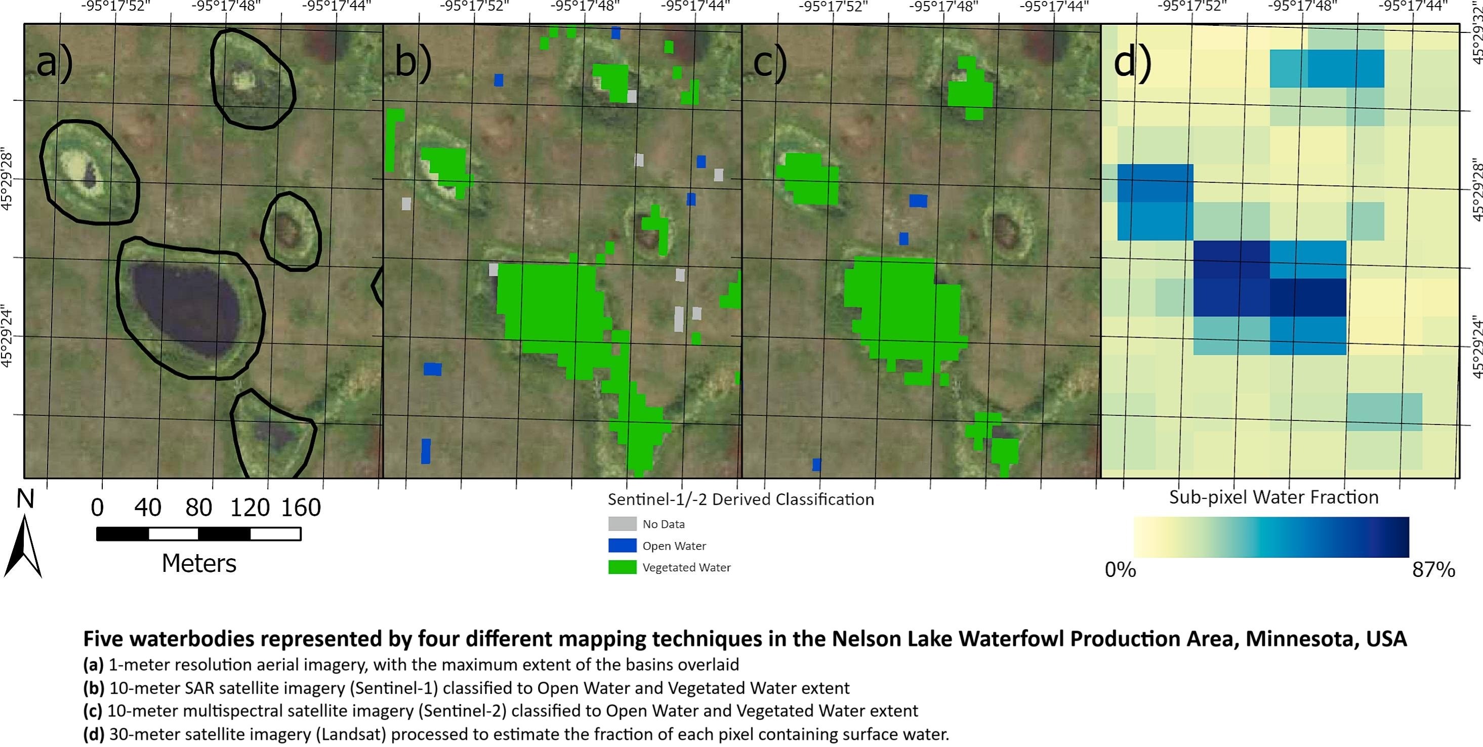
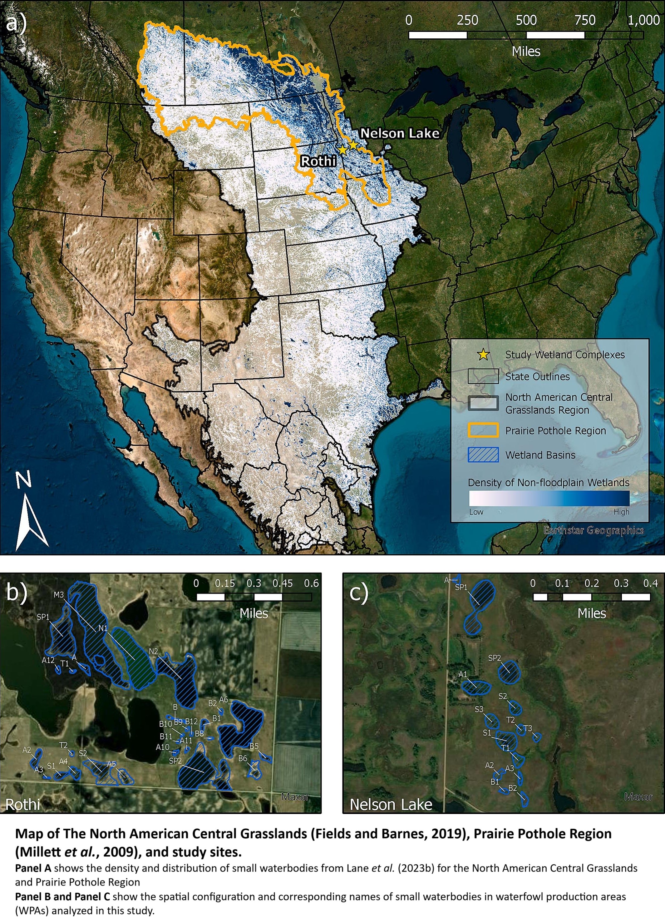
Small Waterbodies Of Large Conservation Concern - Towards An Integrated Approach To More Accurately Measuring Surface Water Dynamics
--
https://doi.org/10.1016/j.ecolind.2025.113525 <-- shared paper
--
“HIGHLIGHTS
• Hydrologic models were used to assess remotely sensed surface water estimates.
• The accuracy of satellite surface water estimates diminished for waterbodies < 2 ha.
• Vegetation reduces accuracy of surface water detection, especially during wet years..."
#GIS #spatial #mapping #waterbodies #Conservation #planning #surfacewater #Hydrologicmodeling #remotesensing #earthobservation #water #hydrology #hydrographic #model #modeling #spatialanalysis #spatiotemporal #waterbody #small #conservation #inventory #monitoring #accuracy #aquatic #vegetation #climate #NorthAmerica #kettle #landforms #landcover #glaciation #prairie #pothole
Saving Lives, One Pixel at a Time - End Users Share Their Stories
--
https://disasterscharter.org/news/saving-lives-one-pixel-at-a-time-end-users-share-their-stories <-- shared technical article
--
“For 25 years the International Charter has organized the distribution and use of satellite and remotely sensed data for response to natural disasters across the globe, informing countless applications where timely acquisition of remote sensing data literally...saves lives…”
--
#GIS #spatial #mapping #webmapping #remotesensing #earthobservation #satellite #imagery #risk #hazard #global #emergencymanagement #naturaldisaster #monitoring #response #planning #management #landsat #hurricane #cyclone #climatechange #extremeweather #flood #flooding #city #urban #crops #agriculture #foodsecurity #infrastructure #emergencyresponse #spatialanalysis #spatiotemporal
@InternationalCharterSpaceAndMajorDisasters | U.S. Geological Survey (USGS) | @earth Resources Observation And Science #EROS
Client Info
Server: https://mastodon.social
Version: 2025.04
Repository: https://github.com/cyevgeniy/lmst