S2Coast-2023 - The First Global 10-Meter Resolution #Coastline Dataset Derived From Enhanced #Sentinel2 Composite #Imagery Using #GoogleEarthEngine
--
https://doi.org/10.1016/j.rse.2025.115186 <-- shared paper
--
https://zenodo.org/records/17092775 <-- shared data
--
“HIGHLIGHTS:
• Developed a GEE-based global coastline detection framework (S2Coast).
• HWLSentinel-2 serves as a unified and stable indicator for global coastline detection.
• The S2Coast-2023 coastline dataset is generated from annual Sentinel-2 imagery.
• Pixel-level accuracy compared with VHR-based OpenStreetMap coastlines..."
#GIS #spatial #mapping #RemoteSensing #CoastalResearch #ClimateChange #EarthObservation #Globalcoastlinemapping #Senitinel #googleearthengine #GEE #Compositing #coast #globe #global #model #modeling #detection #marine #terrestrial #ecosystems #knowledgebased #framework #spatialanalysis #spatiotemporal #QAQC
#GoogleEarthEngine


Google rolls out WeatherNext 2 for sharper forecasts
https://fed.brid.gy/r/https://nerds.xyz/2025/11/google-weathernext-2-ai-model/
Cada día veo más cerca el cambio a un servicio de pago de Google Earth Engine. Gasto que seguramente cubran las universidades.
Otra forma de pagar con impuestos a empresas privadas supongo.
La verdad, que si no fuera por la gran base de datos que tienen y la facilidad para descargarla (el 99% de para lo que lo uso), ni lo notaría.
Google ha publicado un nuevo dataset en su plataforma Google Earth Engine y está dando financiación para miniproyectos que lo usen. Me han propuesto que intente conseguir uno de estos miniproyectos --porque suma como IP que es tremendamente complejo de conseguir en España para noveles como yo (o eso dicen). El problema es que, según tengo entendido, Google está dando soporte al genocidio en gaza perpetrado por Israel.
Como me da urticaria saber esto, estoy sopesando si pedirlo o no. En caso de hacerlo, seguramente le proponga al jefe de hacerlo sobre la extensión del genocidio en Gaza. Seguramente no pasaría el filtro, pero no veo otra forma de usar el dinero de Google si no es para denunciar a Israel.
Por otro lado, la UE no se queda atrás en cuánto al genocidio y es la que financia uno de los proyectos en los que he estado trabajando.
Atrapado me siento.
#Google #GoogleEarthEngine #GenocidioEnGaza #Israel #Gaza #UE #UniónEuropea #Genocidio #Palestina
🧰 Practical GIS Tools
Have you explored Google Earth Engine? 🌍
It’s a planetary-scale platform for accessing and analyzing massive Earth science datasets, all powered by Google’s cloud infrastructure. ☁️📊
Earth Engine empowers researchers, policymakers, and developers to turn geospatial data into real-world insights.
🔗 Start exploring: https://earthengine.google.com/
#GeoTech #GIStools #EarthObservation #GoogleEarthEngine #GeospatialTechnologies #PracticalGIS #RemoteSensing #SpatialAnalysis


„Wirtualny satelita” od Google. AlphaEarth Foundations widzi więcej i dokładniej niż kiedykolwiek
Google DeepMind oraz Google Earth Engine zaprezentowały AlphaEarth Foundations – nowy, fundamentalny model sztucznej inteligencji, który ma zrewolucjonizować sposób, w jaki monitorujemy i analizujemy zmiany na powierzchni Ziemi.
Narzędzie działa jak „wirtualny satelita”, łącząc dane z wielu źródeł, aby stworzyć spójny i niezwykle szczegółowy obraz naszej planety.
Nowy model AI rozwiązuje dwa kluczowe problemy w obserwacji Ziemi: przeciążenie danymi oraz niespójność informacji pochodzących z różnych satelitów. AlphaEarth Foundations integruje petabajty danych – od optycznych zdjęć satelitarnych, przez radar, po symulacje klimatyczne – w jedną, zunifikowaną cyfrową reprezentację. Analizuje całą powierzchnię lądową i wody przybrzeżne Ziemi z precyzją do kwadratów o boku 10 metrów.
Kluczową innowacją jest tworzenie bardzo kompaktowych podsumowań danych, które wymagają 16 razy mniej miejsca na dysku niż w przypadku innych testowanych systemów AI. Jak podaje Google, w testach porównawczych model AlphaEarth Foundations był stale najdokładniejszy, osiągając średnio o 24% niższy wskaźnik błędu niż inne testowane modele.
Our new AI model AlphaEarth Foundations is mapping the planet in astonishing detail. 🌏🔍
Scientists will now be able to track the impact of deforestation, monitoring crop health, and more – significantly faster, thanks to our new datasets. 🧵 pic.twitter.com/rbojUifykg
— Google DeepMind (@GoogleDeepMind) July 30, 2025
Dane dostępne dla wszystkich
Aby przyspieszyć badania i umożliwić nowe zastosowania, Google udostępnia roczne zbiory danych wygenerowane przez model w ramach publicznego zestawu „Satellite Embedding dataset” w Google Earth Engine. Dzięki temu naukowcy, rządy i organizacje pozarządowe mogą prowadzić zaawansowane analizy, często przy użyciu zaledwie kilku linijek kodu.
Z danych korzysta już ponad 50 organizacji na całym świecie, w tym Organizacja Narodów Zjednoczonych do spraw Wyżywienia i Rolnictwa (FAO), Group on Earth Observations (GEO) oraz czołowe uniwersytety, jak Stanford czy Oregon State University.
„Zestaw danych Satellite Embedding rewolucjonizuje naszą pracę, pomagając krajom w mapowaniu niezbadanych dotąd ekosystemów – jest to kluczowe dla ustalenia priorytetów w działaniach na rzecz ochrony przyrody” – mówi Nick Murray, dyrektor Global Ecology Lab na James Cook University i lider projektu Global Ecosystems Atlas.
Innym przykładem jest organizacja MapBiomas, która wykorzystuje dane AlphaEarth do mapowania brazylijskich ekosystemów i analizowania zmian w rolnictwie. „Ten zestaw danych może odmienić sposób, w jaki pracuje nasz zespół – mamy teraz nowe możliwości tworzenia map, które są dokładniejsze, precyzyjniejsze i szybsze w produkcji” – powiedział Tasso Azevedo, założyciel MapBiomas. Google opublikowało również wideo (załączone powyżej z postu na X), na którym można zobaczyć, jak model radzi sobie z „widzeniem” przez chmury w Ekwadorze czy mapowaniem złożonej powierzchni Antarktydy.
#AI #AlphaEarthFoundations #Google #GoogleDeepMind #GoogleEarthEngine #MapBiomas #mapowanie #news #obserwacjaZiemi #sztucznaInteligencja #zmianyKlimatu

High Spatial-Resolution Satellite Mapping Of Suspended Particulate Matter In Global Coastal Waters Using Particle Composition-Adaptive Algorithms
--
https://doi.org/10.1016/j.rse.2025.114745 <-- shared paper
--
https://tssmapping.projects.earthengine.app/view/sscmap <-- shared SedXplorer: Global Coastal Suspended Sediment Explorer (web mapping tool)
--
#GIS #spatial #mapping #remotesensing #coastal #coast #sediment #dynamics #suspendedparticulatematter #particlecomposition #watertype #classification #Landsat #GoogleEarth #GoogleEarthEngine #GEE #opendata #spatialanalysis #spatiotemporal #sedimentology #SPM #earthobservation #model #modeling #marine #estaurine #water #hydrology #geomorphology #global #river #erosion #waterquality #turbidity


So it seems from the lack of responses to my previous post https://fediscience.org/@jgomezdans/114427792187001051 that no one is using the #Copernicus #DataSpace via #STAC. I guess most academic #geo peeps use #GoogleEarthEngine or just download the data files directly? Is STAC only really used by commercial #satellite "bros"?
Striking Satellite Images Reveal Antarctica Is 10 Times Greener Than 35 Years Ago
--
https://www.sciencealert.com/striking-satellite-images-reveal-antarctica-is-10-times-greener-than-35-years-ago <-- shared technical article
--
https://doi.org/10.1038/s41561-024-01564-5 <-- shared paper
--
#GIS #spatial #mapping #remotesensing #landsat #change #Antarctic #AntarcticPeninsula #spatialanalysis #spatiotemporal #climatechange #greening #vegetation #change #warming #satellite #browning #cryosphere #anthropogenic #warming #moss #terrestrial #ecosystems #GoogleEarthEngine #NDVI #TCG #icefree #model #modeling


![photos - Moss-dominated ecosystems across the AP [Antarctic Peninsula]](https://files.mastodon.social/cache/media_attachments/files/113/632/144/276/548/722/original/8fd172097836a44b.jpg)
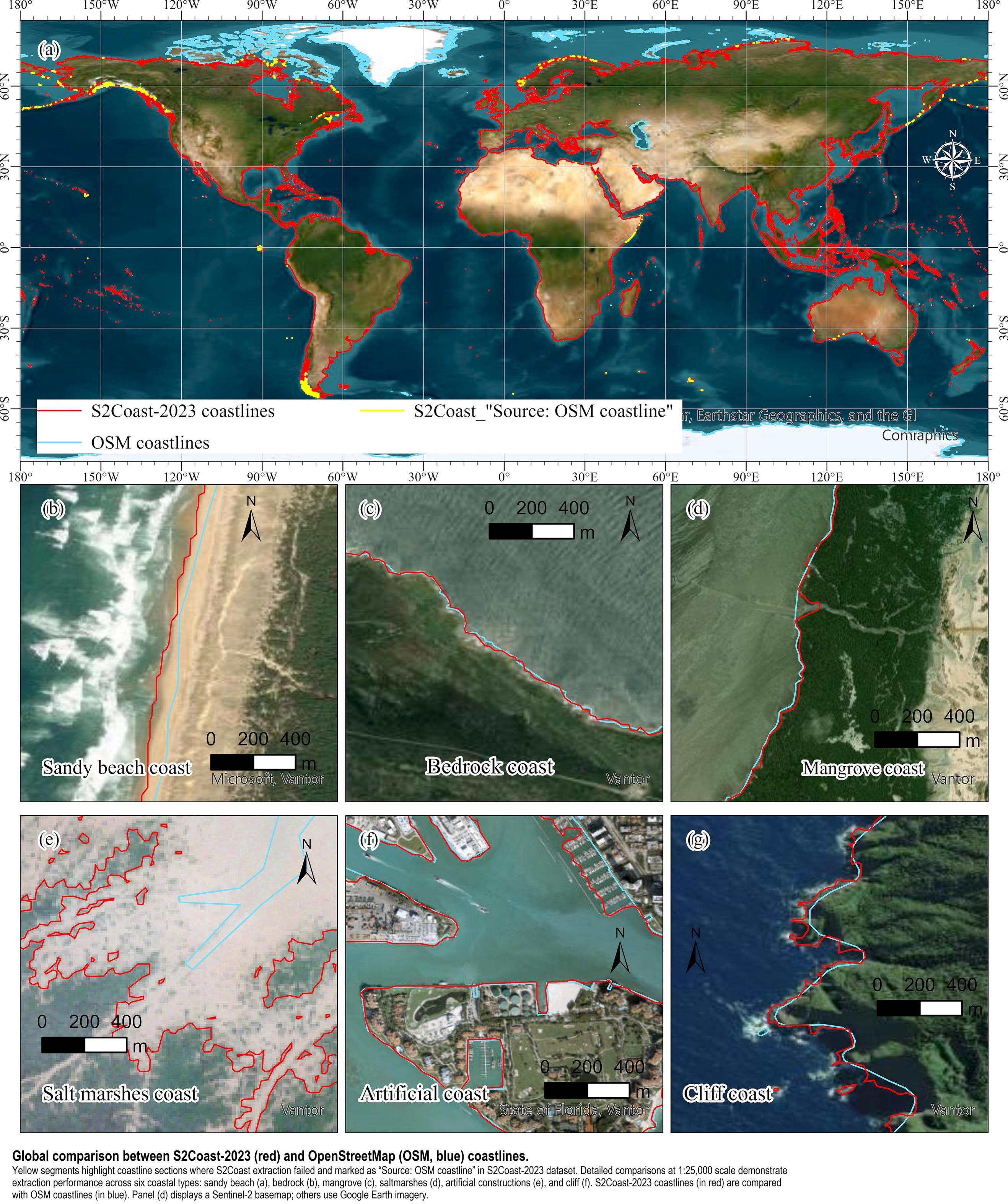
New [2018] 30 Metre Resolution Global Shoreline Vector And Associated Global Islands Database For The Development Of Standardized Ecological Coastal Units
--
https://doi.org/10.1080/1755876X.2018.1529714 <-- shared 2018 paper
--
#GIS #spatial #mapping #coast #coastline #global #shoreline #landsat #remotesensing #spatialanalysis #extraction #AI #machinelearning #GSV #GSHSS #ecology #terrestrial #marine #ECU #waters #GEO #GoogleEarthEngine #MBON #BluePlanet #water #hydrography #hydrospatial #GroupOnEarthObservations
@GroupOnEarthObservations #islands @GEOSEC2025


Cropland Abandonment Between 1986 And 2018 Across The United States - Spatiotemporal Patterns And Current Land Uses
--
https://doi.org/10.1088/1748-9326/ad2d12 <-- shared paper
--
https://www.agdaily.com/crops/study-30-million-acres-cropland-abandoned-since-1980s <-- shared media article
--
#GIS #spatial #mapping #spatiotemporal #USA #spatialanalysis #crops #cropland #abandoned #remotesensing #landsat #imagery #CONUS #AI #USDA #OgallalaAquifer #GoogleEarthEngine #CNN #machinelearning #irrigation #ConservationReserveProgram #landuse #landcover #planning #management #economics

Sunday Funday. If you've been interested in getting your feet wet in #GoogleEarthEngine, I've made a small tutorial to get you started. In this entry, we visualize the sediment being discharged into the Guild of Mexico by the mighty Mississippi.
https://shawncarter.blog/google-earth-engine-using-functions-and-mapping-over-image-collections/

Descubren nuevas especies de nematodos en Costa Rica
San José, 29 nov (elmundo.cr) – Investigadores de la Universidad Nacional (UNA) descubrieron nuevas especies de nematodos anillados en Costa Rica, aportando valiosos conocimientos a la agricultura mundial. El coordinador del Laboratorio de Nematología de la U [...]
#AgriculturaSostenible #CienciaYTecnología #GoogleEarthEngine #NematodosEnCostaRica #NuevosNematodos #RedesDeConocimiento #Tendencias #UniversidadNacional
https://elmundo.cr/tendencias/descubren-nuevas-especies-de-nematodos-en-costa-rica/

#30DayMapChallenge Day 23: Memory
This map by Noel Gorelick, co-founder of #GoogleEarthEngine & newest Kontur team member, combines Hansen Global Tree Cover/Loss dataset & 80+ workshop locations (from memory) that helped Earth Engine "map" its impact 🌲🌍.
#30DayMapChallenge2024


This has been a long time coming, and not the end of it either. The slow squeeze of Google Earth Engine has started.
First came the commercial offerings, now they are pushing people by default to Google Cloud (i.e. have your credit card on the ready).
For those on the free tier, you will see less capacity (stronger quota). And, you will be squeezed, again and again. The market uptake is high enough, so the free ride is over.

This composite is created by my #GoogleEarthEngine app, which provides a very simple interface for creating Sentinel-1-based multitemporal composites. The open-access app can be used by anyone interested in exploring this technique's capabilities.
Find the app here 👉 https://niklasjordan.users.earthengine.app/view/multitempviewer
[🧵 3/3]
A new paper from my @mscactions #UnderTheSands project has been recently published
Application of Multi-Temporal and Multisource Satellite Imagery in the Study of Irrigated Landscapes in Arid Climates
https://www.mdpi.com/2072-4292/16/11/1997
@giap_icac
@CAA_int
#remotesensing #GoogleEarthEngine #Sentinel1 #sentinel2 #Landsat5 #irrigation #LandscapeArchaeology
#tandemx @dlr @mdpiopenaccess
@hector_orengo
@sonaguliyeva et al. (2023) applied #machinelearning algorithms in mapping #croptypes using high resolution #Azersky imagery & demonstrated the value of #opensource platforms like #GoogleEarthEngine in the #classification of crops #LoLManuscriptMonday https://bit.ly/Guliyeva_2023
Shout out to Sona's co-authors & affiliated organizations #Azercosmos #NationalAviationAcademy #Azerbaijan #EOChat #GISChat


Area Estimation of Mango and Coconut Crops using Machine Learning in Hesaraghatta Hobli of Bengaluru Urban District, Karnataka [India]
--
https://doi.org/10.58825/jog.2023.17.1.75 <-- shared paper
--
#GIS #spatial #mapping #spatialanalysis #Mango #Coconut #Areaestimation #Machinelearning #ConvolutionalNeuralNetwork #CNN #RandomForest #RF #agricultural #agriculture #farming #estimates #Karnataka #India #acreage #production #horticulture #commodities #export #remotesensing #satellite #GoogleEarthEngine #GEE #Copernicus #Sentinel2 #algorithms #learning #google #ml
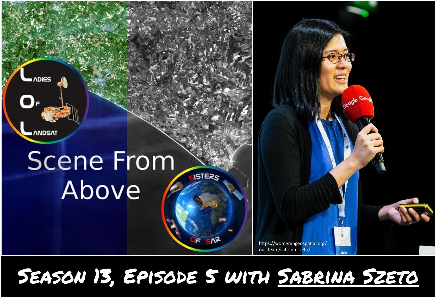
Our newest episode of #SceneFromAbove with special guest @sabrinaszeto has launched TODAY! 🚀✨
Tune in to hear about Sabrina's work with #GoogleEarthEngine & #EarthEngineUserMeetup, advocacy through Women+ in Geospatial, & more! 🎉🛰️ #EOChat #gischat
⭐ S13E5 link ⭐ :
https://scenefromabove.podbean.com/e/s13e5-empowering-geospatial-innovation-with-sabrina-szeto/
Thanks to Sabrina for joining us! And thanks to @rafaelatiengo, @morganahcrowley & @flaviamendes for your efforts this episode! 🛰️
✨Season 13 of #SceneFromAbove is brought to you by Geoawesomeness and UP42 ✨