#KittyHawk

2025-06-16

If you're out trying to fly your bicycle with wings off a sand dune, tonight's not the night!!

Flash Flood Warning issued June 15 at 11:18PM EDT until June 16 at 2:30AM EDT by NWS Newport/Morehead City NC


FFWMHX

The National Weather Service in Newport/Morehead City has issued a

* Flash Flood Warning for...
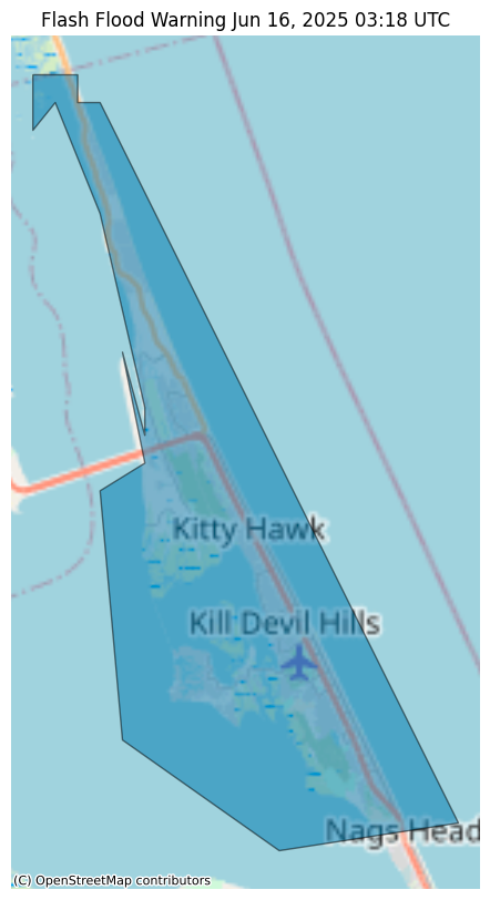
North Central Dare County in eastern North Carolina...

* Until 230 AM EDT.

* At 1118 PM EDT, Doppler radar indicated thunderstorms producing
heavy rain across the warned area. Between 1 and 2 inches of rain
have fallen. Additional rainfall amounts of 1 to 2 inches are
possible in the warned area. Flash flooding is ongoing or expected
to begin shortly.

HAZARD...Flash flooding caused by thunderstorms.

SOURCE...Radar.

IMPACT...Flash flooding of small creeks and streams, urban
areas, highways, streets and underpasses as well as
other poor drainage and low-lying areas.

* Some locations that will experience flash flooding include...
Kill Devil Hills, Southern Shores, Colington, Sanderling, Avalon
Pier, Wright Brothers National Monument, Nags Head Fishing Pier,
Jockeys Ridge State Park and Duck Coe Pier.

#NCwx #KittyHawk #FlashFloodWarning

alerts-v2.weather.gov/search?i

Flash Flood polygon over Kitty Hawk,  NC
๐Ÿ“ก Flight Radar Mechelen ๐Ÿ‡ง๐Ÿ‡ชRadarMechelen
2025-06-04

Flight:
ICAO code:
Callsign:
Operator: Uk Royal/vip Flights Mil
Country: ๐Ÿ‡ฌ๐Ÿ‡ง
Speed: 579 kmh
Altitude: 2187 m
Distance: 2.7 km
Angle โˆ†: 38.6ยฐ
Direction ->: ENE
Track:
tinyurl.com/24j9pf7w
History:
radarbox.com/data/mode-s/407D8F
Seen: 5x

๐Ÿ“ก Flight Radar Mechelen ๐Ÿ‡ง๐Ÿ‡ชRadarMechelen
2025-03-13

Flight:
ICAO code:
Callsign:
Operator: Uk Royal/vip Flights Mil
Country: ๐Ÿ‡ฌ๐Ÿ‡ง
Speed: 733 kmh
Altitude: 9746 m
Distance: 2.3 km
Angle โˆ†: 77.0ยฐ
Direction ->: WNW
Track:
tinyurl.com/24qjkdes
History:
radarbox.com/data/mode-s/43C5EE
Seen: 3x

Mistigris computer artsmistfunk@oldbytes.space
2024-12-17

Mistodon: on this date 121 years ago, Orville Wright became the first person to ever make a sustained airplane flight (for 12 seconds at least) near #KittyHawk, North Carolina. AdeptApril has drawn this #ANSIart illustration of the #WrightFlyer in honour of the occasion.

The earliest primitive aircraft, two layers of drooping wings and a small engine on top of sled rails, briefly takes flight into the grey sky at the Kill Devil Hills.
2024-11-10

The (also known as the ,[3][4] Flyer I or the 1903 Flyer) made the first sustained flight by a manned heavier-than-air powered and controlled aircraftโ€”an airplaneโ€”on December 17, 1903.[1] Invented an

๐Ÿ“ก Flight Radar Mechelen ๐Ÿ‡ง๐Ÿ‡ชRadarMechelen
2024-09-18

Flight:
ICAO code:
Callsign:
Operator: Uk Royal/vip Flights Mil
Country: ๐Ÿ‡ฌ๐Ÿ‡ง
Speed: 514 kmh
Altitude: 3048 m
Distance: 7.9 km
Angle โˆ†: 21.1ยฐ
Direction ->: SSW
Track:
globe.adsbexchange.com/?icao=4
globe.adsb.fi/?icao=407D8F&lat
History:
radarbox.com/data/mode-s/407D8F
Seen: 4x
bit.ly/3yX9TbL

๐Ÿ“ก Flight Radar Mechelen ๐Ÿ‡ง๐Ÿ‡ชRadarMechelen
2024-06-13

Flight:
ICAO code:
Callsign:
Operator: Uk Royal/vip Flights Mil
Country: ๐Ÿ‡ฌ๐Ÿ‡ง
Speed: 543 kmh
Altitude: 2050 m
Distance: 0.3 km
Angle โˆ†: 81.1ยฐ
Direction ->: ENE
Track:
globe.adsbexchange.com/?icao=4
globe.adsb.fi/?icao=407D8F&lat
History:
radarbox.com/data/mode-s/407D8F
Seen: 2x
bit.ly/3yX9TbL

Coach Pฤแน‡ini ยฎpaninid@mastodon.world
2024-03-03

@onthisday

This is a little over a decade after the #WrightBrothers at #KittyHawk and about a year after the assassination of #FranzFerdinand.

#history @histodons โ˜๏ธ

๐Ÿ“ก Flight Radar Mechelen ๐Ÿ‡ง๐Ÿ‡ชRadarMechelen
2024-02-16

Flight:
ICAO code:
Callsign:
Operator: Uk Royal/vip Flights Mil
Country: ๐Ÿ‡ฌ๐Ÿ‡ง
Speed: 768 kmh
Altitude: 12192 m
Distance: 7.2 km
Angle โˆ†: 59.3ยฐ
Direction ->: WNW
Track:
globe.adsbexchange.com/?icao=4
globe.adsb.fi/?icao=407D90&lat
History:
radarbox.com/data/mode-s/407D90
Seen: 9x
bit.ly/gift-for-radar-mechelen

๐Ÿ“ก Flight Radar Mechelen ๐Ÿ‡ง๐Ÿ‡ชRadarMechelen
2024-02-14

Flight:
ICAO code:
Callsign:
Operator: Uk Royal/vip Flights Mil
Country: ๐Ÿ‡ฌ๐Ÿ‡ง
Speed: 513 kmh
Altitude: 2096 m
Distance: 1.6 km
Angle โˆ†: 52.5ยฐ
Direction ->: ENE
Track:
globe.adsbexchange.com/?icao=4
globe.adsb.fi/?icao=407D90&lat
History:
radarbox.com/data/mode-s/407D90
Seen: 8x
bit.ly/gift-for-radar-mechelen

2023-12-17

December 17 marks the anniversary of the #WrightBrothers first flite at #KittyHawk. To honor the moment we #quote #WilburWright and back it with a picture of a modern day flite. If this #quotograph speaks to you please #repost it.

2023-12-17

๐—ช๐—œ๐—ž๐—œ๐—ฃ๐—˜๐——๐—œ๐—” ๐—ฃ๐—œ๐—–๐—ง๐—จ๐—ฅ๐—˜ ๐—ข๐—™ ๐—ง๐—›๐—˜ ๐——๐—”๐—ฌ

โœง Wright Flyer โœง

The Wright Flyer, also known as the Kitty Hawk, made the first sustained flight by a manned heavier-than-air powered and controlled aircraft โ€“ an airplane โ€“ on December 17, 1903. Invented and flown by the Wright brothers, it marked the beginning of the pioneer era of aviation. The Wright Flyer is a single-place biplane design with anhedral (droopi...

#KittyHawk #NorthCarolina #ScienceMuseum #Wikipedia
en.wikipedia.org/wiki/Wright_F

2023-10-24

#OnThisDay, October 24, in 1902, Wilbur Wright achieved a turn in a glider over the Kill Devil Hills in Kitty Hawk, North Carolina, using wing-warping and the movable rudder (depicted in The Winds of Kitty Hawk, 1978)

#Movies #Film #Cinemastodon #Letterboxd #TodayInHistory #Histodons #KittyHawk #Aviation #TheWindsOfKittyHawk #WrightBrothers

A man laying on his front in a wood and cloth glider, coasting on the air
๐Ÿ“ก Flight Radar Mechelen ๐Ÿ‡ง๐Ÿ‡ชRadarMechelen
2023-10-10

Flight:
ICAO code:
Callsign:
Operator: Uk Royal/vip Flights Mil
Country: ๐Ÿ‡ฌ๐Ÿ‡ง
Speed: 556 kmh
Altitude: 1676 m
Distance: 0.6 km
Angle โˆ†: 69.0ยฐ
Direction ->: ENE
Track:
globe.adsbexchange.com/?icao=4
globe.adsb.fi/?icao=407D90&lat
History:
radarbox.com/data/mode-s/407D90
Seen: 6x
bit.ly/gift-for-radar-mechelen

๐Ÿ“ก Flight Radar Mechelen ๐Ÿ‡ง๐Ÿ‡ชRadarMechelen
2023-07-03

Flight:
ICAO code:
Callsign:
Operator: Uk Royal/vip Flights Mil
Country: ๐Ÿ‡ฌ๐Ÿ‡ง
Speed: 551 kmh
Altitude: 1753 m
Distance: 1.9 km
Angle โˆ†: 42.2ยฐ
Direction ->: ENE
Track:
globe.adsbexchange.com/?icao=4
globe.adsb.fi/?icao=407D8F&lat
History:
radarbox.com/data/mode-s/407D8F
Seen: 1x
bit.ly/gift-for-radar-mechelen

2023-03-25

#SpaceSaturday: The #Apollo 14 Command Module, named Kitty Hawk for the first place a heavier-than-air aircraft took off, just decades before #spacecraft took people to the #Moon.
#KittyHawk is on display at the #museum at the Kennedy #Space Center Visitors Complexโ€™s Apollo/Saturn V Center, alongside a full-sized #SaturnV #rocket. It was recovered from the Pacific Ocean after landing by the USS New Orleans.
It sent Alan Shepard and Edgar Mitchell to the Moon, and Stuart Roosa into lunar orbit along on #KittyHawk.
#Photograph, #Photography, #Photograph, #Apollo14, #KennedySpaceCenter, #KSC, #KSCVC, #ApolloSaturnVCenter, #USSNewOrleans, #CommandModule, #ApolloProgram, #ApolloCommandMondule, #Florida, #FlowSpacecraft
heronfox.pixels.com/featured/a

A photograph of a scorched Apollo Command Module, a cone-shape with a rounded bottom. The surface is mostly scorched brown and orange. The hatch is open, allowing the view of the complex opening system and inside the capsule. A rail occupies the foreground at the bottom of the image.A photograph of a scorched Apollo Command Module, a cone-shape with a rounded bottom. The surface is mostly scorched brown and orange. The hatch is open, allowing the view of the complex opening system and inside the capsule. A rail occupies the foreground at the bottom of the image.

Client Info

Server: https://mastodon.social
Version: 2025.04
Repository: https://github.com/cyevgeniy/lmst