Just learned about #qgis #server light by @opengisch #qgisserver #pyqgis
https://github.com/opengisch/qgis-server-light
#QGISServer
🤿 Enfilez vos combinaisons de containers et plongez dans les profondeurs de QGIS server, pour le déployer avec docker, un article qui vous ouvrira les flux OGC vers l'architecture de la cité legendaire.
✒️ Paul Blottiere
👓 @pjeremie, @lbartoletti, Benoit De Mezzo, @CabiecesJ, @geojulien
https://geotribu.fr/articles/2025/2025-04-15_official-qgis-server-docker-image/
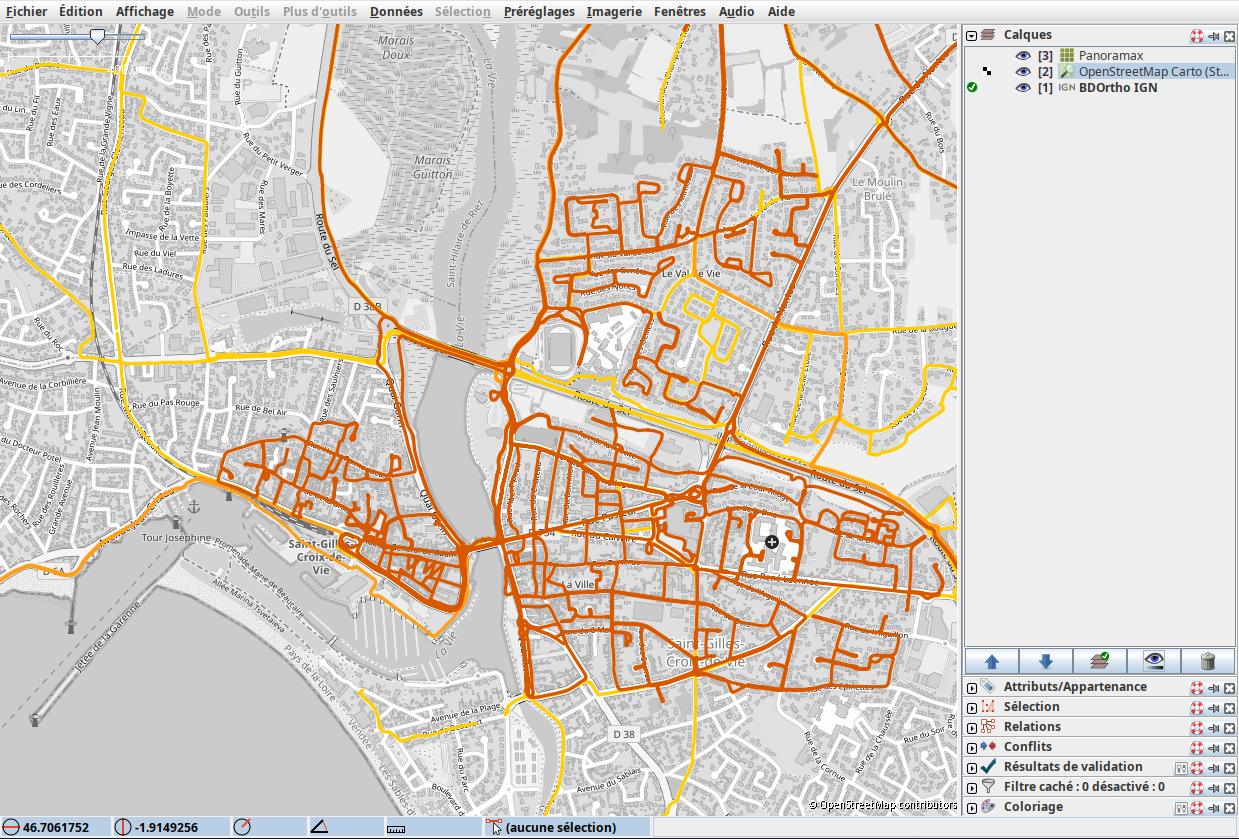
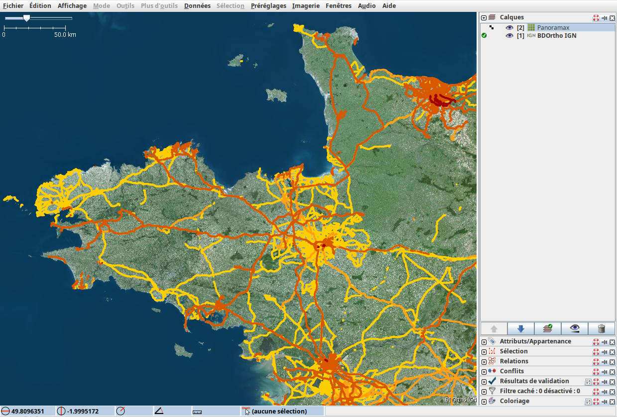
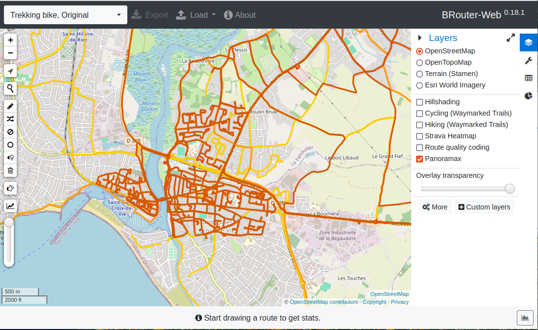
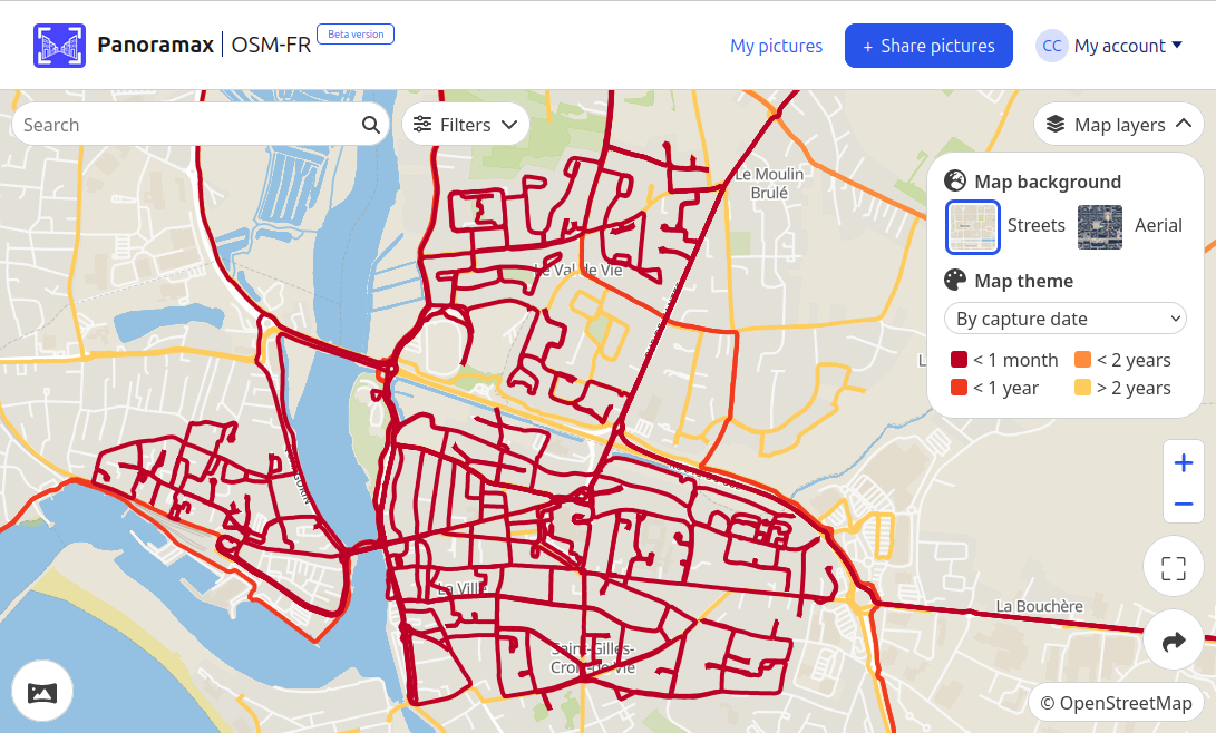
J'arrive maintenant à servir le rendu des séquences @panoramax avec #qgisserver après la mise à jour de la version 3.40 !
Ce sera très pratique dans #JOSM, #OsmAnd, #BRouterWeb, etc. 😀
Hey #gischat
has anyone experience #caching a #WMS server like #QGISServer with #varnish ?
@tomchadwin Thanks for mentioning. We have now a slightly improved version published: https://plugins.qgis.org/plugins/QuickWebViewer/
Still a long way to go to make it that smooth and fine-grained as #qgis2web, but it's a start to build a solution for low tech requirements and heavy maps suitable for the cheapest servers on the market. It's thought to fill the gap between your plugin and #QGISServer
Have a look at first examples we published using the plugin: https://censo2021.quickwebviewer.org/ and https://urba-conakry.quickwebviewer.org/
List of existing #docker images for #QGISServer #qgis
https://gist.github.com/JakobMiksch/121fc8f75a94b21aac3a43847bb7faa4
Got a few more #QGISServer experiments done today: no luck with .qgz files but the same project worked if saved as .qgs 👩💻🤷♀️
#QGIS Server — #Docker edition
Today's post is a #QGISServer update. It's been a while (12 years 😵) since I last posted about QGIS Server. It would be an understatement to say that things have evolved since then, not least due to the development of Docker which, Wikipedia tells me, was released 11 years ago. There have been multiple Docker images for QGIS Server provided by QGIS Community members over the years.
http://anitagraser.com/2024/04/20/qgis-server-docker-edition/
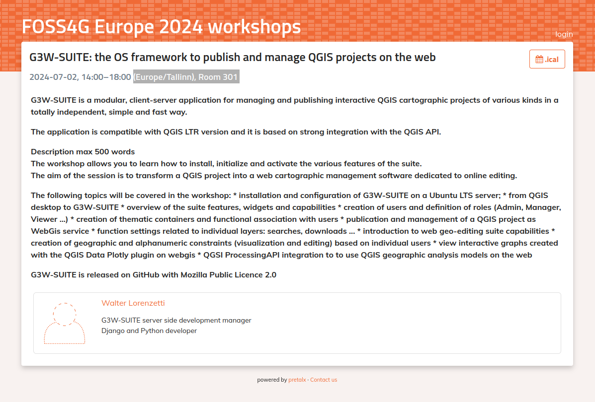
🌟📢 Announcing the G3W-Suite Workshop at FOSS4G-Europe! 🌟📢
📅 Date: 2024-07-02
🕒 Time: 14:00–18:00 (Europe/Tallinn), Room 301
📍 Location: Tartu
This workshop will immerse you in:
✨ Plublish as webgis service your QGIS project.
✨ Active online geospatial service.
✨ Create a structurated and organized webgis services portal.
✨ And much more ...
For inquiries and additional information, info@gis3w.it.
https://talks.osgeo.org/foss4g-europe-2024-workshops/talk/EUMGTD/
🌟 #G3WSUITE tips 🌟
To deploy a specific version of G3W-SUITE, build a new Docker image adding `--build-arg="G3W_SUITE_BRANCH=v3.7.4" ` where the `v3.7.4` is the release version:
```
docker build -f Dockerfile.g3wsuite-deps.ltr.dockerfile --build-arg="G3W_SUITE_BRANCH=v3.7.4" -t g3wsuite/g3w-suite-deps-ltr:v3.7.x --no-cache .
```
J'ai mis en ligne un projet #QGIS qui permet d'afficher les séquences des photos #Panoramax par dates/ancienneté. On peut modifier les périodes en manipulant la symbologie.
C'est ce rendu que je n'arrive pas faire servir par #qgisserver pour faire des tuiles raster.
https://gitlab.com/cartocite/panoramax_mvt_qgis_style
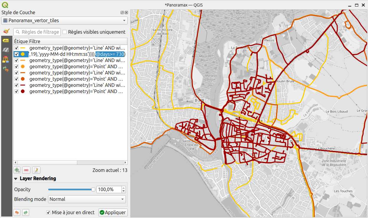
Does anyone know why #qgisserver does not render a vector tile layer to serve it in #WMTS ? I would like to use it to serve classic XYZ raster tiles rendered from #PANORAMAX's vector tiles to organize my collection more easily. I asked here: https://gis.stackexchange.com/questions/475405/render-vector-tiles-layer-with-wms-wmts-qgis-server
Aujourd'hui c'est la journée mondiale du lézard ! Bonne fête à #Lizmap et merci à l'équipe autour de ce projet @kimaidou, @etrimaille (et j'en oublie) pour ce formidable outil. https://www.lizmap.com/ #QGIS #QGISServer #Webmapping
Say hi to the #QWC2 emoji on Mapstodon! :qwc2:
#qgis #qgisserver
Client Info
Server: https://mastodon.social
Version: 2025.04
Repository: https://github.com/cyevgeniy/lmst