#qgis2web

2025-04-29

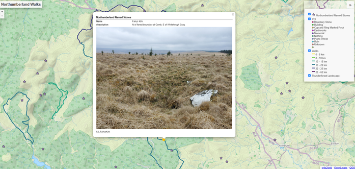
figured out a few upgrades to my walks map: Changing colour on hover is an obvious one as I keep doing walks that overlap and are the same length, so there's no colour difference.

I also added an image field to the Named Stones layer, so now I can just correctly name a picture of the stone and drop it into the folder and it will pop up on the layer. Points without images show a broken icon though. I should probably set the image popup size too..
sarahdal.github.io/Walks/

#QGIS #QGIS2Web

a pop-up on a leaflet map of my walks, which shows an area of countryside and forestry dotted with circles (points o finterest I've found) and stars (named stones of northumberland) as well as walking routes I've done. The pop up shows Fairys Kirk, a whit boulder in long rough grass on the edge of a conical depression.
2025-03-17

@robintw The correct answer is #qgis2web.

2024-07-11

Pleasure to be involved with the Railway Land Wildlife Trust #mapping the new habitats being created in #Lewes by local people/partners for the Mosaic project lnkd.in/g-jHMT3D.
Window boxes for pollinators, tree planting, swift boxes.
If you live in Lewes get involved & spread the word.
I've also used my cartographic licence to produce a 'mosaic' of the mosaic. Looking forward to seeing some interesting
patterns emerging during the project.
#gis #qgis #qgis2web #cartography
#geospatial

2024-07-04

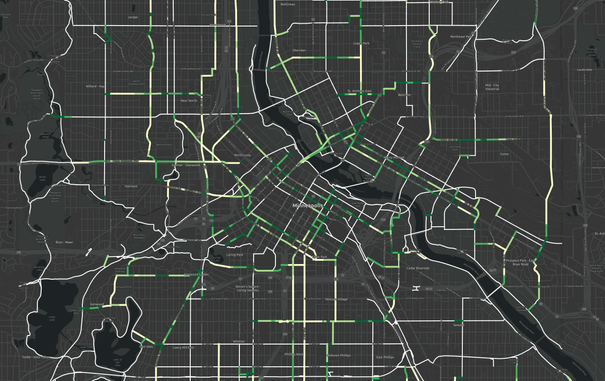
And until I get a #qgis2web workflow going with interactive slippy maps, here's a zoomed version towards downtown. It ranks new connections in the dense downtown higher, which makes sense. Shorter connections between the existing network tend to rank higher. What's sort of imperfect but expected is that sometimes one block ranks higher than the block next to it. It could use some "smoothing" to even out the ranks of coordinators. Next, I'll share more of the method to create this. #minneapolis🧵

2024-06-14

Since Andrea took over management and development of #qgis2web, I've not kept so much of an eye on it. That means I missed the most amazing milestone:

QGIS2WEB HAS NOW BEEN DOWNLOADED OVER A MILLION TIMES

I'm so pleased Andrea has given the plugin such a new lease of life. He is ploughing a huge amount of time, effort, and expertise into it, and it's wonderful to see new releases coming and coming.

2024-05-21

@tomchadwin Thanks for mentioning. We have now a slightly improved version published: plugins.qgis.org/plugins/Quick

Still a long way to go to make it that smooth and fine-grained as #qgis2web, but it's a start to build a solution for low tech requirements and heavy maps suitable for the cheapest servers on the market. It's thought to fill the gap between your plugin and #QGISServer

Have a look at first examples we published using the plugin: censo2021.quickwebviewer.org/ and urba-conakry.quickwebviewer.or

2024-05-01

Very interesting new QGIS plugin, to sit alongside #qgis2web. QuickWebViewer exports QGIS projects to MapLibre: gitlab.com/300000-kms/QuickWeb #OneToWatch #webmapping

2024-03-26

I cannot tell you how happy I am that Andrea has just developed and released v 3.19.0 of #qgis2web, in which AT LAST layer groups are properly supported. This is the single biggest longstanding issue which affected the plugin, and it's a huge step forward. Thanks, Andrea!

github.com/qgis2web/qgis2web/r

2024-03-18

@askans @underdarkGIS @stevenfeldman @mapguy @sourcepole @felt @leaflet @openlayers If your data is served as WMS/WFS, then yes, the #qgis2web map will always pull remote data.

2024-02-13

Bumper #qgis2web release last night by Andrea Ordonselli:

- layer title in layerswitcher in without style
- openlayers popup visible on click if "highlight
on hover" active
- improved OpenLayers
popup graphics
- "popuplayertitle" prints layer title in openlayers popup
- max height/width for popup images
- clustered data in openlayers popup
- fixed second click popup issue
- measurement/geolocate now above basemaps and layers, as well as popup

github.com/qgis2web/qgis2web/r

2024-01-26

@rony Once I installed #QGIS via Conda, the #qgis2web plugin worked, but it was immediately clear that it was approximating the design I had in the map, not exactly replicating it. So for a project where I want precise design control, I'm not sure it will be the best fit, but it would still be the first thing I would evaluate the next time I have a QGIS project I want to turn into a slippy map.

I think once I learn better what it can can't do, it could be a good tool in my toolbox.

2024-01-11

@rony For a period I had access to ArcGIS online and loved it for styling and presenting data. But hosting / subscription costs are not scaled for individuals who want very long term storage. Also, I prefer #OpenSource Right now, I'm living without a good slippy map replacement that's easy to manage and self-host. I've started to look at #qgis2web But I welcome any new alterantives in this category! For now, I'm back to publishing static maps at mark.stosberg.com/mapping

MiKlo:~/citizen4.eu$💙💛miklo@soc.citizen4.eu
2023-12-29
@tomek
Trzeba by koniecznie dodać że w tym przypadku gotowe=własnościowe .
Ten sam "zasrany geojson" można w kilka minut zamienić w interaktywną mapę o podobnej funkcjonalności wyłącznie przy pomocy klikania (bez pisania kodu) w wolnym oprogramowaniu. Np #QGIS + #qgis2web
2023-12-12

#qgis2web announcement!

The qgis2web repository has moved. It is now no longer in my Github account, but under a new qgis2web organization. This should be largely transparent, but take care if you have a local clone - check your upstream repo.

github.com/qgis2web/qgis2web

Also, Andrea has released v3.17.1! github.com/qgis2web/qgis2web/r

Anita Graser 🇪🇺🇺🇦🇬🇪underdarkGIS@fosstodon.org
2023-12-02

@tomchadwin Great. Does that mean that #qgis2web and #qgis2opengis development is going to merge? #qgis plugins.qgis.org/plugins/autho

2023-12-01

More terrific #qgis2web news: as well as Andrea starting work on the plugin, @osgeouk have granted him funding to achieve some specific improvements. Thanks to my colleagues on the committee!

plugins.qgis.org/plugins/qgis2

Anita Graser 🇪🇺🇺🇦🇬🇪underdarkGIS@fosstodon.org
2023-11-30

Hey #GISChat / #QGIS Chat: is there a tool to export a web map with raster layers that gives the user an identify tool to get the raster values? #Qgis2web and #qgis2threejs will show the raster but I couldn't find a way to get an identify tool for raster values, ideally supporting multiple bands

#webmapping #openlayers #leaflet

2023-11-29

I'm delighted to announce that Andrea Ordonselli has started work on #qgis2web. Please give him any support you can, as my beloved plugin which I've had to neglect for several years gets some much-needed attention at last. Thanks, Andrea!

github.com/tomchadwin/qgis2web

Askan 🇪🇺askans@bonn.social
2023-09-17

@underdarkGIS @stevenfeldman @mapguy @sourcepole @felt @leaflet @openlayers I have to check with #qgis2web if it works with APIs in order to always fetch the most current data once the @leaflet map is published

Client Info

Server: https://mastodon.social
Version: 2025.04
Repository: https://github.com/cyevgeniy/lmst