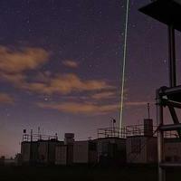
#Saharastaub: Der #Himmel ist weiß, die #Sonne ist #weiß! - Kurzbericht unseres #Lidar- Experten Albert Ansmann zum #Staub über #Deutschland > https://www.tropos.de/aktuelles/science-blog/beitrag/saharastaub-1 / #saharandust #Fernerkundung #ACTRISl @leibnizgemeinschaft @unileipzig @RSAtmos_LIM
#SaharanDust


Therre be blood rain in these parrts!
#SaharanDust


☀️ Desert dust from the Sahara — 4,000 km away — is literally falling on British cars right now.
🌅 Amber skies. Red rain. And a science reason nobody explains properly.
Hint: iron oxides are involved.
🔗 Read the full story 👇
https://www.karmactive.com/saharan-dust-plume-uk-blood-rain-amber-sunsets-explained/
Follow @karmactive for more updates
#CopernicusAtmosphere dust aerosol optical depth forecast shows a massive #SaharanDust plume crossing NW Africa, W Mediterranean + parts of Europe through the first week of March.
Read our article about how and why dust transport happens and the potential impact on our health.
https://atmosphere.copernicus.eu/what-saharan-dust-and-how-does-it-change-atmosphere-and-air-we-breathe
View the latest aerosol forecasts:
https://atmosphere.copernicus.eu/charts/packages/cams/products/aerosol-forecasts?layer_name=composition_duaod550&projection=classical_europe
Our scientist @m_parrington is available for comments on the latest episode.
📈 Another data visualisation of the same #SaharanDust plume based on data for 17 Feb
2️⃣ https://www.instagram.com/p/DU-SQR_jB8h/
Explore Copernicus #ImageOfTheDay https://www.copernicus.eu/en/media/image-day-gallery/saharan-dust-plume-over-atlantic-ocean
⬇️

Three charts based on #CopernicusAtmosphere data you shouldn’t miss this month:
📈 Intense #SaharanDust plume over the North Atlantic reaching western Europe – CAMS - Sebastian Steinig
1️⃣ https://bsky.app/profile/copernicusecmwf.bsky.social/post/3mfc2xpy76c2x
Explore our forecasts: https://atmosphere.copernicus.eu/charts/packages/cams_air_quality/products/europe-air-quality-daily-aggregated-forecast-aerosol-tracers
⬇️


The intense #SaharanDust plume over the North Atlantic is predicted to reach western Europe in the coming days in the #CopernicusAtmosphere forecast. These episodes are not uncommon at this time of the year, particularly impacting air quality and visibility in Canary Islands and Madeira. Further afield there is the possibility of dust deposition and/ or hazy skies.

07.30 am, Monday.
#SaharanDust is still hanging around.

I can't help it when the sky is orange


📉 #SaharanDust transport episode affecting Greece mid-January – AtmoHub

The #CopernicusAtmosphere regional ensemble forecast shows an intrusion of #SaharanDust reaching Spain and the western Mediterranean, before moving towards France, Italy and SE Europe this week.
📉 Long-range transports of #SaharanDust crossing the Atlantic - CAMS
1️⃣ https://bsky.app/profile/copernicusecmwf.bsky.social/post/3ltwnmda5bc2b
Read the article: https://atmosphere.copernicus.eu/frequent-saharan-dust-plumes-tracked-across-atlantic-and-over-europe
📉 Smoke plumes from Canadian #wildfires crossing the North Atlantic towards Europe – Mark Parrington
2️⃣ https://bsky.app/profile/mparrington.bsky.social/post/3lu6pphbrss2g
📉 Saharan dust transport episode affecting parts of the Mediterranean region – AtmoHub
3️⃣ https://www.linkedin.com/posts/atmohub_copernicusatmosphere-atmohub-airquality-activity-7354426708776693760-wocy
3 charts based on #CAMS data you shouldn’t miss this month:
📉 Smoke transport from Canadian #wildfires meets #SaharanDust – Sebastian Steinig / CAMS
1️⃣ https://bsky.app/profile/copernicusecmwf.bsky.social/post/3lrxivn5zkc2a
Read the article https://atmosphere.copernicus.eu/new-cams-video-shows-intense-dust-and-smoke-activity-over-europe?utm_source=socialmedia&utm_medium=bs&utm_campaign=new-cams-video-shows-intense-dust-and-smoke-activity-over-europe
📉 Global #wildfires intensity & emissions for June – Mark Parrington / CAMS
2️⃣ https://bsky.app/profile/mparrington.bsky.social/post/3lsv5gjkyfk2d
📉 #Heatwaves bringing high surface #ozone levels across Europe - CAMS
3️⃣ https://bsky.app/profile/copernicusecmwf.bsky.social/post/3lstdii6dmk2o
Latest forecast charts https://atmosphere.copernicus.eu/charts/packages/cams_air_quality/products/europe-air-quality-daily-aggregated-forecast-regulated

Saharan dust could bring hazy skies and vivid sunsets to Houston. But it also could pose serious health risks for people with respiratory conditions.
#Houston #Local #News #Weather #AirQuality #HoustonAir #HoustonWeather #SaharanDust #UTHealthHouston
🔥 A feedback loop in motion
More fires → more soot → more melt → more warming → more fires. This loop is especially dangerous in the Arctic and high mountain regions, where glacier loss has knock-on effects for sea level rise, water supply, and biodiversity
💙 We can change this collectively - by reducing the burning of fossil fuels, preventing wildfires, and traveling sustainably. Follow Glacierwatch for more facts about Glaciers.

#Hazy sky to persist as Canadian #WildfireSmoke and #SaharanDust invade US
More smoke and dust are ahead for the northern, eastern and southern states into mid-June, as AccuWeather meteorologists continue to track Canadian wildfires and dust sweeping in from Africa.
By Bill Deger, AccuWeather senior meteorologist
Published Jun 5, 2025 11:10 AM EDT | Updated Jun 6, 2025
"The haze is here to stay. Rounds of smoke from hundreds of Canadian wildfires, as well as dust blowing off Sub-Saharan Africa, will continue to envelop portions of the United States into the summer, say AccuWeather meteorologists.
"Recent rounds of smoke blowing across the northern and eastern U.S. over the last week resulted in a hazy sky, poor air quality and vibrant sunrises and sunsets. While the smoke has mostly retreated back into Canada as of late this week, additional episodes are expected through the summer, with the first expected early next week.
"Meanwhile, the Saharan dust will result in similar effects in the South, mostly in Florida and areas surrounding the Gulf and southwestern Atlantic. A recent round of dust blowing off of Africa will also have the effect of putting a temporary lid on potential tropical development."
#CanadianWildfires #Wildfires #NortheasternUS #ClimateChange #ClimateChangeWeatherWheel

Golden sunrise in Santo Domingo, filtered through the Saharan Dust. Even when nature brings haze, beauty finds a way to shine. 🌅✨
#SantoDomingo #SunriseVibes #SaharanDust #GoldenHour #NatureMood #CaribbeanSky #MorningGlow #TropicalViews #NaturePhotography #IslandMornings #DominicanRepublic #DustySky #SunriseMagic #MoodyMorning
#SantoDomingo #SunriseVibes #SaharanDust #GoldenHour #NatureMood #CaribbeanSky #MorningGlow #TropicalViews #NaturePhotography #IslandMornings #DominicanRepublic #DustySky #SunriseMagic #MoodyMorning

📉 Episode of #SaharanDust transport across north Africa to the eastern Mediterranean reaching Greece, Turkey and Cyprus 23-25 May – CAMS
3️⃣ https://bsky.app/profile/copernicusecmwf.bsky.social/post/3lprba5imac2q
#CopernicusAtmosphere aerosol optical depth 5-day forecast shows the latest episode of #SaharanDust transport across north Africa to the eastern Mediterranean reaching Greece, Turkey and Cyprus 23-25 May.
Latest forecast chart: https://atmosphere.copernicus.eu/charts/packages/cams/products/aerosol-forecasts?layer_name=composition_aod550&projection=classical_europe
Client Info
Server: https://mastodon.social
Version: 2025.07
Repository: https://github.com/cyevgeniy/lmst