🔔#Earthquake (#sismo) M2.1 strikes 9 mi NE of #Indio (#California) 2 min ago. More info: https://m.emsc.eu/?id=1818821
#INDIO
Un #experto #militar de #EEUU #US explica la victoria de las #armas #chinas contra el #Rafale #indio
www.elconfidencial.com/tecnologia/n...
Un experto militar de EEUU exp...
Profesor indio arrestado por el puesto de redes sociales sobre operación marcial | Parte de tensiones de India-Pakistán #arrestado #IndiaPakistán #indio #militar #Noticias #operación #por #Profesor #puesto #redes #sobre #sociales #tensiones #ButterWord #Spanish_News Comenta tu opinión 👇
https://butterword.com/profesor-indio-arrestado-por-el-puesto-de-redes-sociales-sobre-operacion-marcial-parte-de-tensiones-de-india-pakistan/?feed_id=22460&_unique_id=6829cd28c7991
El derribo de un caza #indio en #Cachemira hace levantar las cejas a los #militares #españoles y #franceses..
https://theobjective.com/tecnologia/2025-05-14/derribo-caza-indio-militares-espanoles/
El derribo de un caza #indio en #Cachemira hace levantar las cejas a los #militares #españoles y #franceses..
theobjective.com/tecnologia/2...
El derribo de un caza indio en...
Sydney at Stagecoach Festival in Indio, California – IG April 2025 https://www.girlselfie.com/640960/sydney-at-stagecoach-festival-in-indio-california-ig-april-2025/ #april #california #festival #Indio #Stagecoach #sydney #SydneySweeney

Estos son los 10 mejores actos de Coachella 2025 | #RollingStoneES
https://es.rollingstone.com/estos-son-los-10-mejores-actos-de-coachella-2025/
#bensonboone #california #coachella2025 #festival #greenday #indio #ladygaga #lisa #listados #parcels
https://www.fogolf.com/943038/desert-arc-holds-annual-golf-fundraiser/ Desert Arc holds annual golf fundraiser #and #Arnold #ArnoldPalmer #Ça #charity #CharityU0026Philanthropy #coachella #CoachellaValley #Desert #designation #Disabilities #donating #Donations #DonationsAndDonating #fundraising #GIVING #Golf #GolfNews #INDIO #nonprofit #NonprofitDesignation #overall #OverallPositive #PALM #PalmSpringsDesertScene #PalmSpringsGiving #Palmer #People #PeopleU0026Society #Philanthropy #Positive #Scene #SOCIETY #Springs #u0026 #Valley

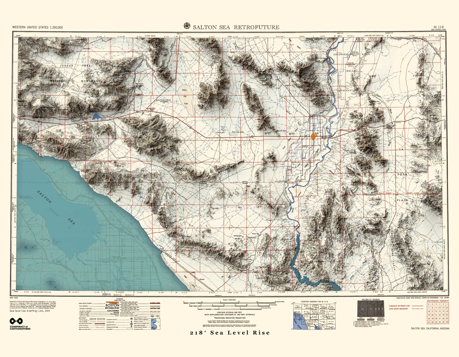
Another #Coachella Valley map from the Retrofuture series… The town of Coachella is to the northwest, this is the 1:250000 USGS quad of the Salton Sea, 1950, with 66m sea level rise. Also, check out Joshua Tree National Monument in the upper left.
More #Retrofuture maps…https://conspiracyofcartographers.com/retrofuture-gallery/
#climateChange #maps #cartography #Indio #ImperialValley #SanAndreasFault #CoachellaValley #SaltonSea #SeaOfCortez #SeaLevelRise #JoshuaTreeNP #WorldBuilding #Futurism #outsiderArt
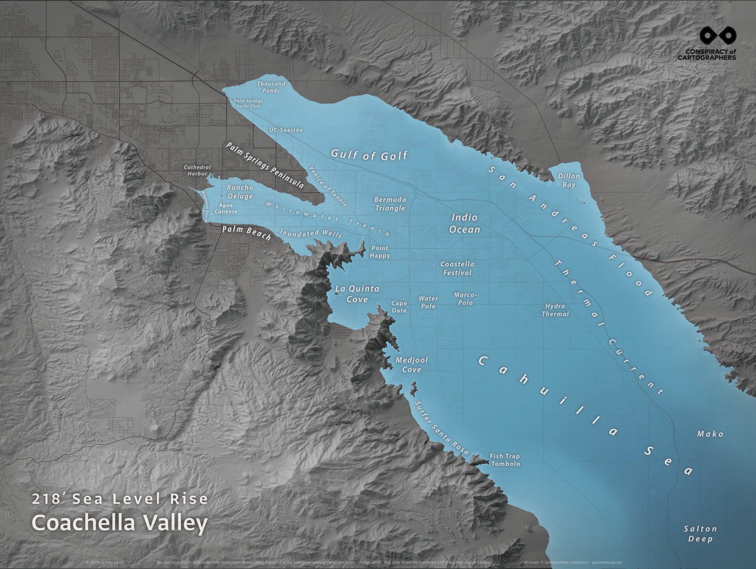
When the ice caps melt, the #Coachella Valley becomes the north end of the Sea of Cortez.
From the Drowned Cities series. You can see more…https://conspiracyofcartographers.com/sea-level-rise-gallery/
#climateChange #maps #cartography #Indio #PalmSprings #PalmDesert #BermudaDunes #CoachellaValley #SaltonSea #SeaOfCortez #SeaLevelRise #WorldBuilding #Futurism #outsiderArt
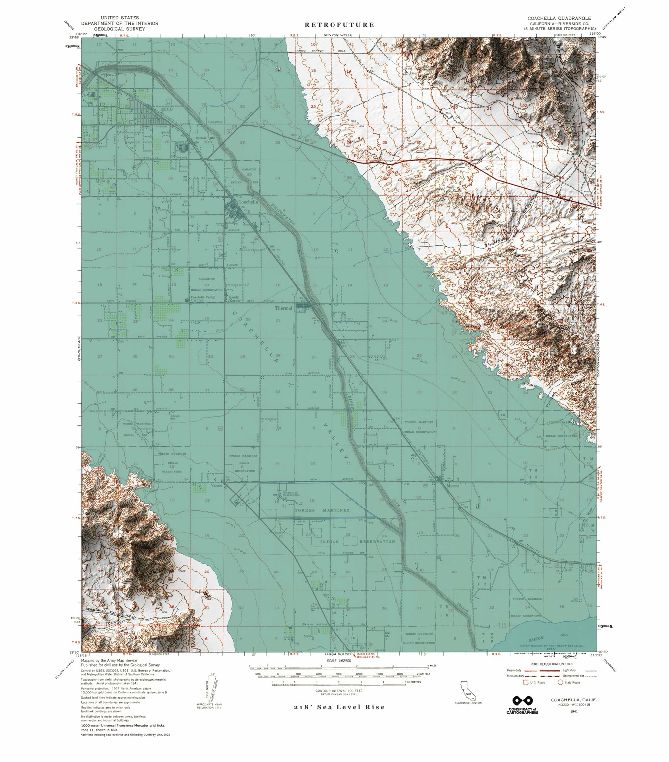
I hear #Coachella is happening. Well, there’s a Retrofuture map for that…
Based on the 1941 USGS quad for Coachella, with 66m sea level rise.
#climateChange #maps #cartography #Indio #GreenWashing #SeaLevelRise #WorldBuilding #Futurism #RetroFuture #SteamPunk #outsiderArt
🔔#Earthquake (#sismo) M2.1 strikes 17 mi NE of #Indio (#California) 2 min ago. More info: https://m.emsc.eu/?id=1793589
🔔#Earthquake (#sismo) M2.1 strikes 17 mi NE of #Indio (#California) 2 min ago. More info: https://m.emsc.eu/?id=1793588
🔔#Earthquake (#sismo) M3.2 strikes 12 mi NW of #Indio (#California) 2 min ago. More info: https://m.emsc.eu/?id=1793185
🔔#Earthquake (#sismo) M2.8 strikes 9 mi E of #Indio (#California) 2 min ago. More info: https://m.emsc.eu/?id=1792237
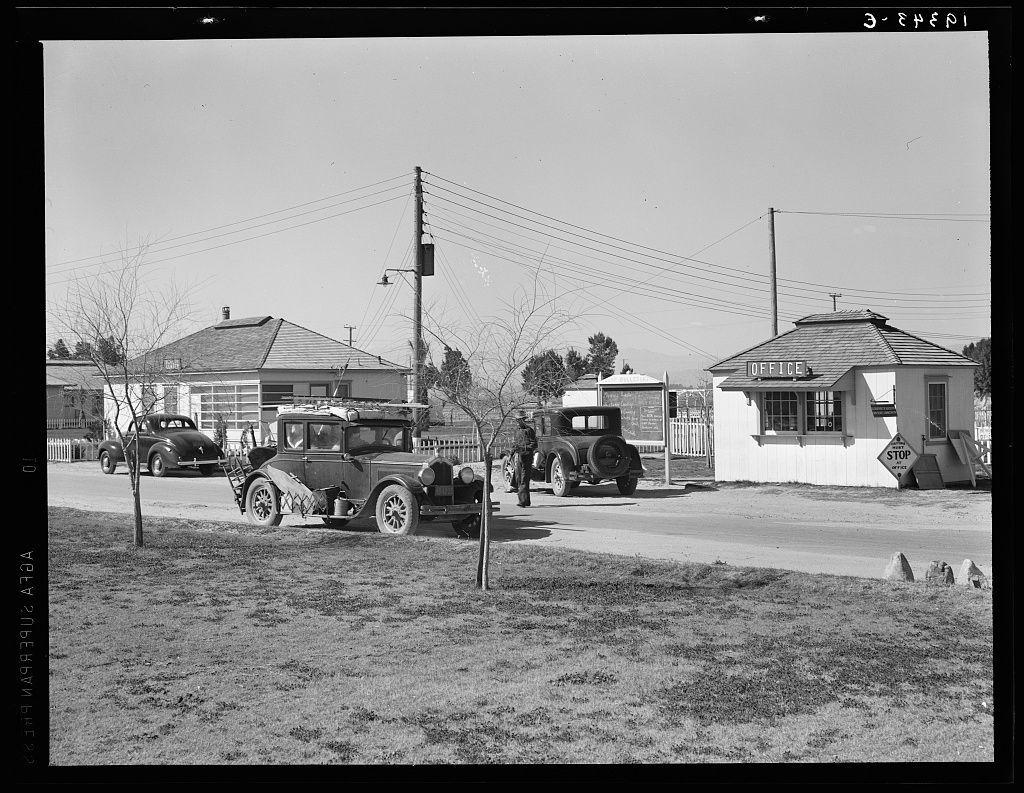
Entering Farm Security Administration (FSA) camp for migratory laborers at Indio. Coachella Valley, California
#Indio #CoachellaValley #California #DorotheaLange #CoachellaValleys #Lange #undefined #photography #DorotheaLange
Padma Lakshmi arrastra a personas influyentes alimentarias para una revisión negativa del restaurante indio con Michelin Star #alimentarias #arrastra #con #del #indio #influyentes #Lakshmi #Michelin #negativa #Padma #para #personas #restaurante #Revisión #Star #una #ButterWord #Spanish_News Comenta tu opini...
https://butterword.com/padma-lakshmi-arrastra-a-personas-influyentes-alimentarias-para-una-revision-negativa-del-restaurante-indio-con-michelin-star/?feed_id=15632&_unique_id=67f0a9dba309c
🔔#Earthquake (#sismo) M2.2 strikes 17 mi E of #Indio (#California) 2 min ago. More info: https://m.emsc.eu/?id=1787027
🔔#Earthquake (#sismo) M2.0 strikes 9 mi NE of #Indio (#California) 2 min ago. More info: https://m.emsc.eu/?id=1786731
Client Info
Server: https://mastodon.social
Version: 2025.04
Repository: https://github.com/cyevgeniy/lmst