The quest to build #islands with #ocean currents in the #Maldives
An alternative to# dredging aims to capture moving sand to protect the archipelago from erosion and #sealevelrise. https://www.technologyreview.com/2025/04/21/1114759/maldives-erosion-climate-dredging/
#SeaLevelRise
.
The picture is part of a series entitled "Normal". I made it for the artistic research project "What If" by @noorderlicht@pixelfed.social and Sign Groningen in 2020. My good friend Kasper posed in the cold water as businessman.
.
.
.
#ThrowbackThursday #photography #sealevelrise #climatechange #contemporaryart #groningen #fotografie #businessasusual
Around the year 2000 26% of Dutch people are living below sea level. Without dikes and dunes 60% of the Netherlands would regularly overflow.
.
The picture is part of a series entitled "Normal". I made it for the artistic research project "What If" by @noorderlicht and Sign Groningen in 2020. My good friend Kasper posed in the cold water as businessman.
.
.
#businessasusual #ThrowbackThursday #photography #sealevelrise #climatechange #contemporaryart #groningen #fotografie
Down To Earth: Antarctic Ice Sheet may have reached tipping point of no return: Study…
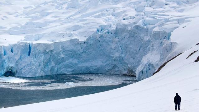
The #Antarctic Ice Sheet, which has the biggest potential for sea-level rise, may be at or very close to a melting tipping point, according to a new study... #icesheet #sealevelrise
Down To Earth: Antarctic Ice Sheet may have reached tipping point of no return: Study…
The #Antarctic Ice Sheet, which has the biggest potential for sea-level rise, may be at or very close to a melting tipping point, according to a new study... #icesheet #sealevelrise
Racing to save NJ island before it's swallowed by rising seas https://phys.org/news/2025-06-nj-island-swallowed-seas.html
How Nantucket Is Preparing for Rising Seas
The Massachusetts island anticipates damages of $3.4 billion through 2070 if nothing is done.
"It’s no longer unusual to see a kayaker paddling along downtown Easy Street.... Easy Street was flooded a record 75 days in 2023."
The coastal resilience plan "so far has identified 40 proposed projects over the next 15 years at a cost of $930 million."
https://insideclimatenews.org/news/06062025/nantucket-sea-level-rise-coastal-resilience/
3-Jun-2025
Scientists say next few years vital to securing the future of the West #Antarctic Ice Sheet
https://www.eurekalert.org/news-releases/1086047 #science #ClimateCatastrophe #antarctica #SeaLevelRise
As Summer Approaches, #NewJersey’s Shore Towns Confront an Unrelenting Foe: #SeaLevelRise
“Sunny day” flooding is now a thing down the shore, where the tides have risen at twice the global average. Sooner or later, “we’re not going to be able to protect everything everywhere,” one state official says.
https://insideclimatenews.org/news/03062025/new-jersey-shore-towns-sea-level-rise/
I was just reading the new science study documenting how we're very close now to (perhaps even past) the ocean temperatures needed to start the irreversible collapse of the West Antarctic Ice Sheet.
"Notably, West Antarctic Ice Sheet collapse contributes over 4 m sea-level rise in equilibrium ice sheet states with little (0.25 °C) or even no ocean warming above present. Therefore, today we are likely already at (or almost at) an overshoot scenario, supporting recent studies warning of substantial irreversible ice loss with little or no further climate warming."
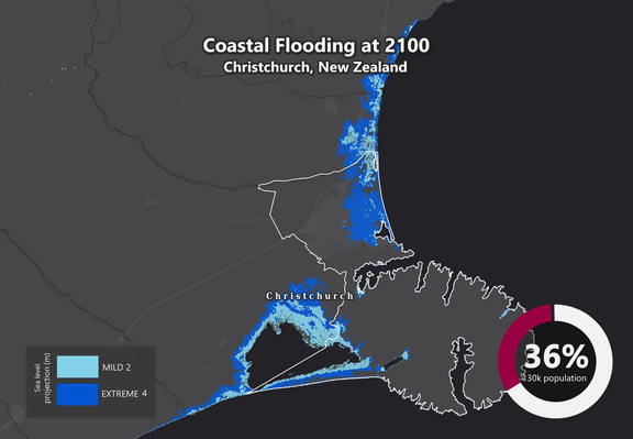
A sea level rise of 4 metres was visualised for Christchurch City, New Zealand, by Earth.org in 2020. It's over a third of our city underwater.
It seems like something we should be doing everything we can to avoid happening.
https://doi.org/10.1038/s43247-025-02366-2
https://earth.org/data_visualization/sea-level-rise-by-2100-christchurch/
https://www.sciencedaily.com/releases/2025/06/250603115018.htm
The Guardian: Almost 40% of world’s glaciers already doomed due to climate crisis – study…
#glaciers #climatechange #sealevelrise #environment #mountains
"While we can come back safely and build back better after most river flooding, there is no coming back for land that coastal erosion has simply taken away or which a rising sea level has put permanently or frequently underwater."
"Which means in some places...
1/2
#ClimateCrisis #SeaLevelRise
RE: https://bsky.app/profile/did:plc:7gms4by3zmzfnrk3bjitsqqn/post/3lqote3iags2l
Study: collapse of #WestAntarctic #IceSheet could be triggered with very little #OceanWarming above present-day, leading to 4 metres of global #SeaLevelRise to play out over hundreds of years.
PIK researcher @juliusgarbe: “We have a narrow window to act.”
https://www.pik-potsdam.de/en/news/latest-news/scientists-say-next-few-years-vital-to-securing-the-future-of-the-west-antarctic-ice-sheet
Ghost forests are growing due to #sealevelrise
As trees choked by #saltwater die along low-lying coasts, #marshes may move in. Arboreal graveyards are showing up in places where the land slopes gently into the ocean and where salty water increasingly encroaches. Along the United States’ East Coast, in pockets of the West Coast, and elsewhere, saltier soils have killed hundreds of thousands of acres of trees, leaving behind woody skeletons typically surrounded by #marsh.
https://arstechnica.com/science/2025/04/ghost-forests-are-growing-as-sea-levels-rise/
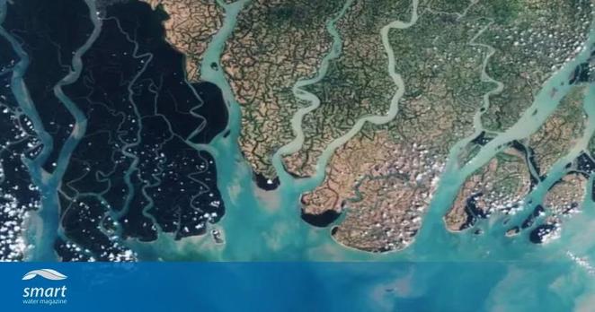
When the sea moves inland: A global climate wake-up call from #Bangladesh's Delta
As sea levels climb and #weather grows more extreme, coastal regions everywhere are facing a creeping threat: salt. #Salinization of #freshwater and #soils adversely affects 500 million people around the world, especially in low-lying #river #deltas.
The western parts of the delta, already more prone to tidal influence, showed the fastest increases in salinity. The data suggests that the combination of #SeaLevelRise, reduced freshwater flow, and increasingly frequent storm surges are all contributing to the inland movement and retention of saltwater.
Since about 2007, many parts of the delta have experienced stepwise increases in salinity, often linked to powerful storms like #Cyclone #Sidr. These changes can devastate crops, erode #FoodSecurity, and force communities to move. While the analysis focused primarily on environmental data, it underscores how salinity intrusion is increasingly a threat to livelihoods, public #health, and regional stability.
The Guardian: Almost 40% of world’s glaciers already doomed due to climate crisis – study…
#glaciers #climatechange #sealevelrise #environment #mountains
"In the next 25 years just 20cm of #sealevelrise will cost around US$1 trillion per year in flood damages across the world's largest coastal cities" says @drgilbz.bsky.social
Present warming is "challenging the implementation of adaptation measures." #climatecrisis
https://www.youtube.com/watch?v=sa9h_zVM1RY
865 #ClimateEmergency #SeaLevelRise
Some scepticals and deniers have a difficulty with large and far away numbers. They can't [won't] grasp the concept of changes in the life time of their grandchildren.
That's not only unforgivable but when it's on purpose it's outright criminal !
Only because they won't change their habits now.
"This is bleak"
"We’re heading for tens of metres of sea level rise" [11:14 min]
by Dr Gilbz
https://www.youtube.com/watch?v=sa9h_zVM1RY
Quote by DrG:
"May 27, 2025
Ice loss from the polar ice sheets will lock us in to multi-metres of sea level rise over the (very) long term. Even today's warming of 1.3 C will result in coastline-altering sea level rise. But how fast seas rise is critically important when it comes to adaptation - and by now it's pretty much the only thing we can control."
More info on
* New paper here: Stokes et al. (2025):
"Warming of +1.5 °C is too high for polar ice sheets
-> nature.com/articles/s43247-025-02299-w <-
* Sea level animation using data from NASA-SSH satellite product, see e.g.
-> podaac.jpl.nasa.gov/dataset/NASA_SSH_GMSL_INDICATOR <-
#TakeCareForLife #TakeCareForEarth
#StopBurningThings #StopEcoside
#StopThePlunder #StopRapingNature
#ClimateBreakDown
Sea level rise expected to accelerate even if warming is limited to 1.5C: Study https://phys.org/news/2025-05-sea-limited-15c.html
#environment #sea #SeaLevel #SeaLevelRise #climate #ClimateChange #ClimateCrisis
New review article: Warming of +1.5 °C is too high for polar ice sheets.
"Multiple lines of evidence show that +1.5 °C is too high and that even current climate forcing (+1.2 °C), if sustained, is likely to generate several metres of sea-level rise over the coming centuries, causing extensive loss and damage to coastal populations and challenging the implementation of adaptation measures."
https://www.nature.com/articles/s43247-025-02299-w
#globalwarming #ClimateChange #ClimatechangeisWaterchange #sealevelrise


