#satelliteImage

2025-06-18

Ponding on the Ice Shelf

Glaciers flow together and march out to sea along the Amery Ice Shelf in this satellite image of Antarctica. Three glaciers — flowing from the top, left, and bottom of the image — meet just to the right of center and pass from the continental bedrock onto the ice-covered ocean. The ice shelf is recognizable by its plethora of meltwater ponds, which appear as bright blue areas. Each austral summer, meltwater gathers in low-lying regions on the ice, potentially destabilizing the ice shelf through fracture and drainage. This region near the ice shelf’s grounding line is particularly prone to ponding. Regions further afield (right, beyond the image) are colder and drier, often allowing meltwater to refreeze. (Image credit: W. Liang; via NASA Earth Observatory)

#fluidDynamics #geophysics #glacier #iceShelf #melting #physics #planetaryScience #satelliteImage #science

Three glaciers flow together from the top, left, and bottom of this satellite image, meeting in an ice shelf dotted with blue meltwater ponds.
2025-04-09

Winter in Chicago

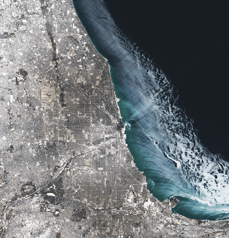
Fresh winter snow blankets Chicago in this satellite image. Over on Lake Michigan, ice dots the coastline out to about 20 kilometers from shore. Darker regions near land mark thinner ice being pushed outward by the wind. Further out, the ice appears white and may be thicker thanks to wind-driven ice piling up. (Image credit: M. Garrison; via NASA Earth Observatory)

#fluidDynamics #iceFormation #physics #satelliteImage #science #wind

Satellite image of Chicago in winter. Fresh snow lies over the city and streaks of ice on the lake show winds pushing away from the shore.
2025-01-15

Blooming in Blue

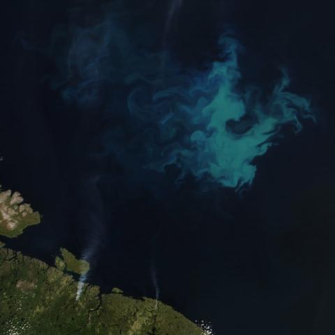
Summers in the Barents Sea — a shallow region off the northern coasts of Norway and Russia — trigger phytoplankton blooms like the one in this satellite image. The blue shade of the bloom suggests the work of coccolithophores, a type of plankton armored in white calcium carbonate. This type of plankton thrives in the warm, stratified waters of the late summer. Earlier in the year, the water tends to be nutrient-rich and well-mixed, conditions which favor diatom plankton species instead. Their blooms appear greener in satellite images. (Image credit: W. Liang; via NASA Earth Observatory)

#flowVisualization #fluidDynamics #mixing #physics #phytoplankton #satelliteImage #science #stratification

This satellite images shows a late summer phytoplankton bloom in the Barents Sea.
2024-12-30

The entire ESMERALDA team wishes you happy end of year celebrations with your friends and family.
We look forward to 2025 a year with many challenges and wonderful perspectives ahead!

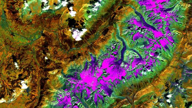
As a treat for the eye, some art from space. @mundialis kindly let us use this image of the Mont Blanc located in France and Italy.

credits to: mundialis
https://www.mundialis.de/en/satellite-image-of-the-month-october-mont-blanc-france-italy/
Sai Phanindras4i@mstdn.party
2024-11-30

looks like emirates to me
#contrails #SatelliteImage

an emirates A380 spotted in satellite imagery
2024-11-27

Lines of Ice Eddies

In February 2024, the North Atlantic’s sea ice reached its furthest extent of the season, limning the coastline with tens of kilometers of ice. These images — both capturing the Labrador coast on the same day — show the swirling patterns marking the wispy edges of ice field. In this region, the ice is likely following an eddy in the ocean below. Eddies like these can form along the edges where warm and cold currents meet. An ice eddy is particularly special, though, as the water must be warm enough to fragment the sea ice, but not so warm that it melts the smaller ice pieces. (Image credit: top – NASA, lower – M. Garrison; via NASA Earth Observatory)

This satellite image shows sea ice off the Labrador coast, on the same day in February 2024.

#astronaut #eddies #flowVisualization #fluidDynamics #physics #satelliteImage #science #seaIce

This astronaut photo shows swirls of sea ice off the Labrador coast in February 2024.This satellite image shows sea ice off the Labrador coast, on the same day in February 2024.
2024-11-06

Fragments of sea ice tumble and swirl in this satellite image of Greenland’s east coast. In spring, Arctic sea ice journeys down the Fram Strait between Greenland and Svalbard. Along the way, large ice floes break — and melt — into smaller pieces. Large pieces of sea ice are visible closer to the coastline, but the smaller individual floes get, the wispier they appear in the satellite image. In the haziest portions of the image, the ice may be only meters across. In recent years, less and less Arctic sea ice has survived the journey southward, shifting the temperature and salinity of Arctic contributions to global ocean circulation. (Image credit: W. Liang; via NASA Earth Observatory)

https://fyfluiddynamics.com/2024/11/sea-ice-swirls/

#circulation #fluidDynamics #oceanCurrents #physics #satelliteImage #science #seaIce

This satellite image shows Atlantic sea ice off the coast of Greenland in June 2024.
2024-11-01

Blue-green algae bloom in Lake Erie’s summer conditions. Unfortunately for those looking to spend summer on the water, the dominant organism in this bloom produces a toxin that “can cause liver damage, numbness, dizziness, and vomiting.” Bloom season can last from late June into October, depending on the how many nutrients get washed into the lake and when wind mixes the lake water in the fall. A new hyperspectral instrument aboard NASA’s PACE spacecraft will identify bloom species from space, helping scientists track, understand, and predict blooms like these. (Image credit: W. Liang; via NASA Earth Observatory)

https://fyfluiddynamics.com/2024/11/erie-algal-bloom/

#fluidDynamics #geophysics #mixing #physics #phytoplankton #satelliteImage #science

An algal bloom in Lake Erie, as seen by an instrument on Landsat 9.
Gerd_BrodowskiGerd_Brodowski
2024-10-25

: / / / /

„Data shows that more than 3,600 buildings in Lebanon appear to have been damaged or destroyed between 2 and 14 October 2024. This represents about 54% of the total estimated damage since cross-border hostilities between Israel and Hezbollah broke out just over a year ago.“

bbc.com/news/articles/cvgx3zjv

2024-10-10

More than a tenth of Antarctica’s ice projects out over the sea; this ice shelf preserves glacial ice that would otherwise fall into the Southern Ocean and raise global sea levels. But austral summers eat away at the ice, leaving meltwater collected in ponds (visible above in bright blue) and in harder-to-spot slush. Researchers taught a machine-learning algorithm to identify slush and ponds in satellite images, then used the algorithm to analyze nine years’ worth of imagery.

The group found that slush makes up about 57% of the overall meltwater. It is also darker than pure snow, absorbing more sunlight and leading to more melting. Many climate models currently neglect slush, and the authors warn that, without it, models will underestimate how much the ice is melting and predict that the ice is more stable than it truly is. (Image credit: Copernicus Sentinel/R. Dell; research credit: R. Dell et al.; via Physics Today)

https://fyfluiddynamics.com/2024/10/slushy-snow-affects-antarctic-ice-melt/

#antarctica #climateChange #fluidDynamics #geophysics #glacier #ice #iceShelf #machineLearning #melting #physics #planetaryScience #satelliteImage #science
This satellite image shows meltwater slush and lakes on the top of Antarctica's Bach Ice Shelf.
2024-09-04

Captured in March 2024, this satellite image of the Gulf of Oman comes from an instrument aboard the PACE spacecraft. The picture of a phytoplankton bloom is not quite natural-color, at least not as our eyes would see it. Instead, engineers combined data taken from multiple wavelengths and adjusted it to bring out the fine details. It’s not what we’d see by eye, but every feature you see here is real.

Traditionally, the only way to identify the species of a phytoplankton bloom like this one is by taking a sample directly. But PACE’s instruments can detect hundreds of wavelengths of light, offering enough color detail that scientists may soon be able to identify and track phytoplankton species by satellite image alone. I wonder if distinguishing species could also provide some quantitative flow visualization from a series of these images. In the meantime, at least we can enjoy the view! (Image credit: J. Knuble; via NASA Earth Observatory)

https://fyfluiddynamics.com/2024/09/swirls-of-green-and-teal/

#eddies #flowVisualization #fluidDynamics #physics #phytoplankton #satelliteImage #science #turbulence

An enhanced satellite image shows flow details within a large phytoplankton bloom in the Gulf of Oman.
2023-11-14

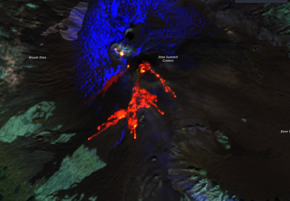
Lava fountains are spectacular, but most of the lava falls back into the crater or spatters just a bit around it. During the activity you still get some overflows, that typically cover one or two kilometers.

#Etna #SEC #lavaFountain #satelliteImage #MtEtna #Sentinel2

False-colors Sentinel-2 image of the lava overflow from the South-East crater during the lava fountain that started on the late evening of November 12. The blue area to North is snow.
mundialis GmbH & Co. KGmundialis
2023-10-19

📢 We are on the cover of the international renowned GIM International Magazins!

Our of Berlin was so great the colleagues took it on their cover 07/2023 including a short

Find it here:
gim-international.com/magazine

Martin Hollandmho@social.heise.de
2023-06-07

The same thre pictures with enhanced colors, make the imense flooding in southern Ukraine even more visible.

#Satellite #Kakhova #Kherson #Ukraine #UkraineWar #Russia #Putin #Dnieper #Dam #SatelliteImage

June 7thJune 6thJune 5th
Martin Hollandmho@social.heise.de
2023-06-07

That's so huge: A #SatelliteImage from today vs. one from two days ago clearly shows the devastating floods in the area around #Kherson, the city itself and the #Dnieper after the #KakhovkaDam broke yesterday in the morning.

#Ukraine #UkraineWar #EarthObservation #NASA #EOSDISWorldview

Satellite image from June 5th. showing the river flowing normalSatellite image from today clearly showing the flooding.
𝕎𝕖𝕤𝕤𝕖𝕩𝕎𝕖𝕒𝕥𝕙𝕖𝕣wessexweather@mastodonapp.uk
2023-06-01

Increasing amounts of marine stratocumulus circulating in this high, as those along the east coast have discovered!
#NOAA18 #weather #ukweather #meteorology #satelliteimage

Client Info

Server: https://mastodon.social
Version: 2025.04
Repository: https://github.com/cyevgeniy/lmst