Realtime trafic project API, with #osmand integration.
https://www.openstreetmap.org/user/Archit%20Rathod/diary/407192
Realtime trafic project API, with #osmand integration.
https://www.openstreetmap.org/user/Archit%20Rathod/diary/407192
Newest test case for route planner: A planner that tells you what the streets are named after in Denmark.
I have "simply" updated the street names with the description from Wikidata and OpenStreetMap. Perhaps I'll style it a bit, but the OSRM part is pretty default otherwise.
The descriptions is in Danish.
![Route planner directions with OSRM that shows the names with descriptions of what they are named after in Danish, such as:
Kør mod Sydvest ad Fuglebakkevej [Fuglebakken; kvarter på Frederiksberg i København]
Drej til venstre ad Godthåbsvej [Store Godthåb; landsted på Frederiksberg]](https://files.mastodon.social/cache/media_attachments/files/114/671/148/494/137/478/original/a8c7542970a0e76d.png)
If you haven't noticed yet: There is a pull request for #OSRM to route over areas – with multipolygon support.
https://github.com/Project-OSRM/osrm-backend/pull/7161
#OpenStreetMap
My route planner for Denmark that refuses to drive on roads named after men is now online:
https://osrm.findvej.dk/nomales/
A couple of examples:
Carlsberg Byen:
https://osrm.findvej.dk/nomales/?z=16¢er=55.667353%2C12.533405&loc=55.665580%2C12.529242&loc=55.665435%2C12.530379&hl=da&alt=0
Today's fun with OpenStreetMap and route planners: A route planner for Denmark that refuses to drive on roads named after men.
About 40,000 Danish roads (= 35 % af all Danish roads) have been tagged with name:etymology:wikidata to tag into Wikidata's structured content.
Other ideas for funny restrictions? Roads named after politicians of specific political parties? Roads named after royals? (¡Viva la revolución!) Roads named after Swedes?
The largest road network TSP instance with 81,998 locations solved optimally was crafted using OSRM! A groundbreaking milestone in computational mathematics. Check out the details here: https://www.math.uwaterloo.ca/tsp/korea/index.html #TSP #Optimization #OSRM
🎉 Big news! OSRM v6.0.0 is live! 🚀 This release boasts 100+ changes, contributions from 170+ developers, and welcomes dozens of first-time contributors! 🌍 Huge thanks to our amazing community! 💪❤️ https://github.com/Project-OSRM/osrm-backend/releases/tag/V6.0.0 #OpenStreetMap #OSRM #RoutingEngine #OSM
Build a Mileage Calculator app in C# using the OSRM API for fast, accurate driving distance calculations! 🚗💨 Learn how to integrate geocoding and routing features in this step-by-step guide. #CSharp #OSRM #MileageCalculator
Tein pikku oppaan päivän ( ja yön) agendasta, eli #OSRM käyttöönotosta Ubuntu 24.04.2 LTS -serverille ja integraatio #nextcloud -pilven kanssa. Kikkailujen ja säätöjen jälkeen toimii.
Oppaaseen täältä -> cloudy.porotokka.net/s/2X7nKaNPwJCfjz8
Päivän agendalla: Reittiohjepalvelin eli #osrm -servon lisääminen #nextcloud purkkiin.
# objetivo: Rutas entre playas de Lecheria
# - En forma didáctica
# salida : Se muestra distancia y tiempo
# proceso : Ruta por ruta:
# - Viaje completo me hizo llorar
#Lecheria #Playas #rstats #ANZ #Anzoategui #Costarica #osrm #Running #Aprender #Educacion #Espacial
Hiermit kommt noch der Hinweis auf die kleine Verewigung des Dankes auf der Vereinswebseite: https://fossgis.de/news/2025_01_27_routing-server-nine/
@awinkler for which region? For car only routing there exist several (#graphhopper, #osrm, #valhalla ), for transit routing, data availability is still an issue. The #transitous project is the largest free instance I‘m aware of. For smaller regions, you might self-host e.g. an #OpenTripPlanner or #MOTIS instance https://transitous.org/
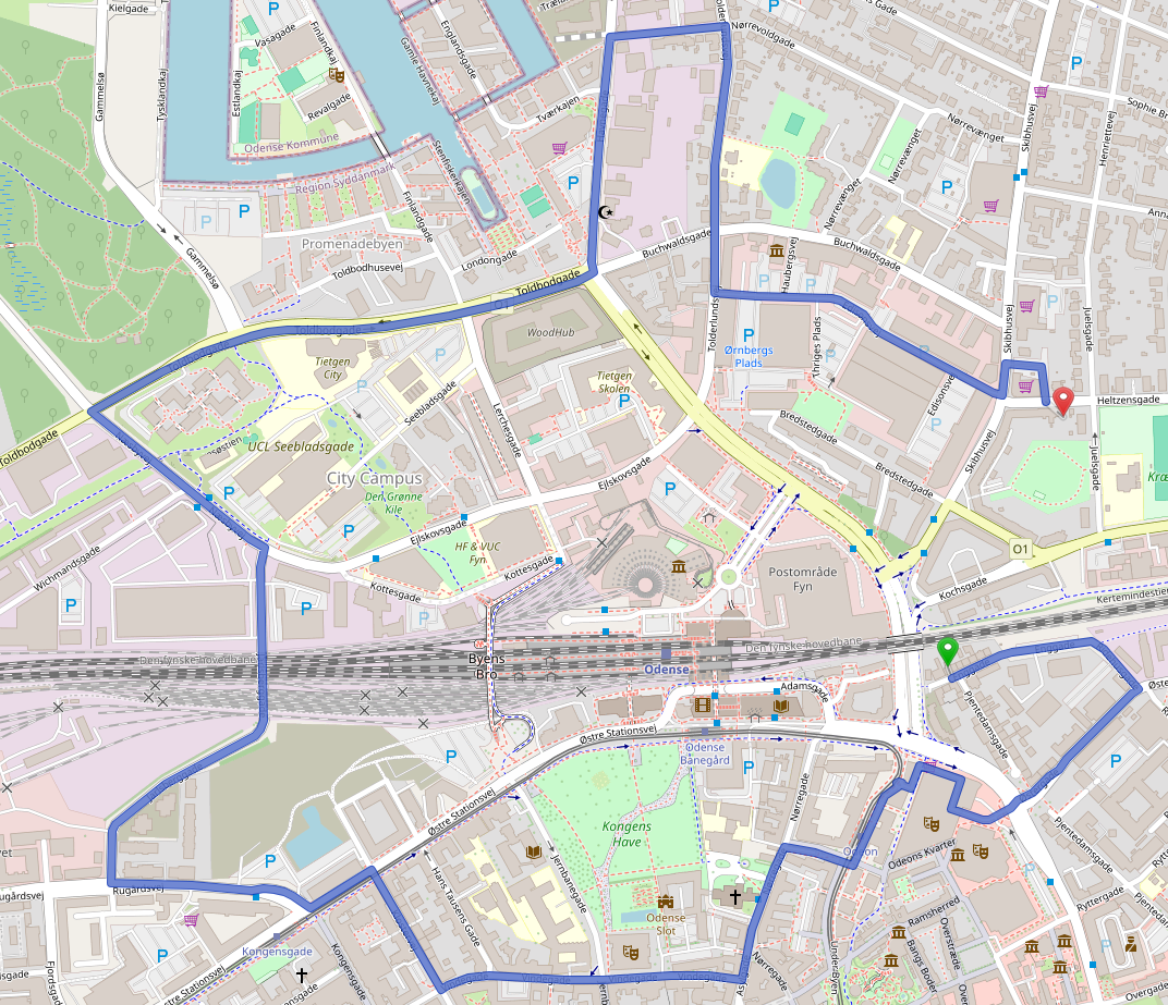
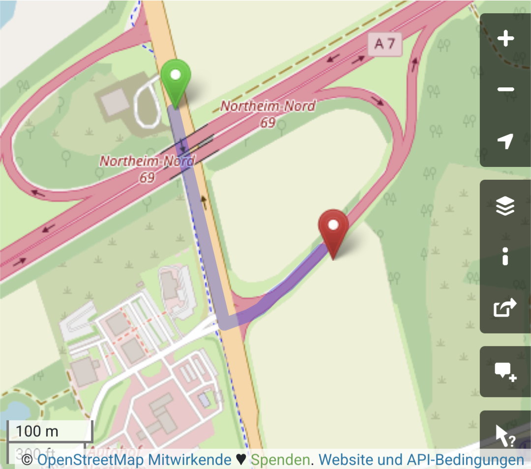
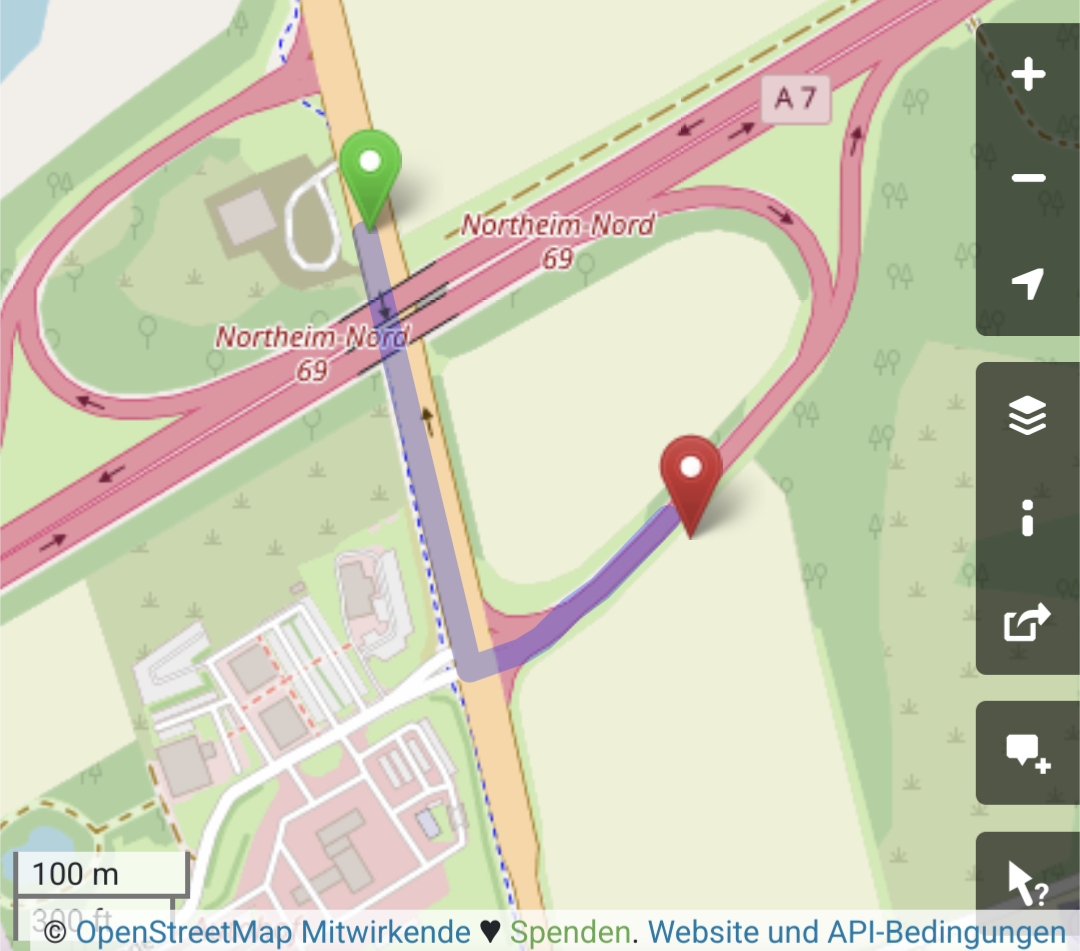
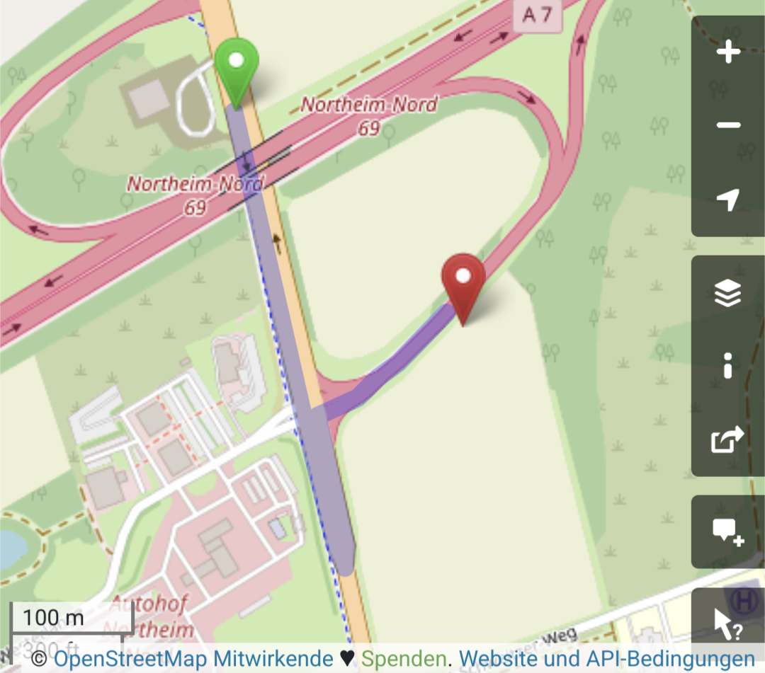
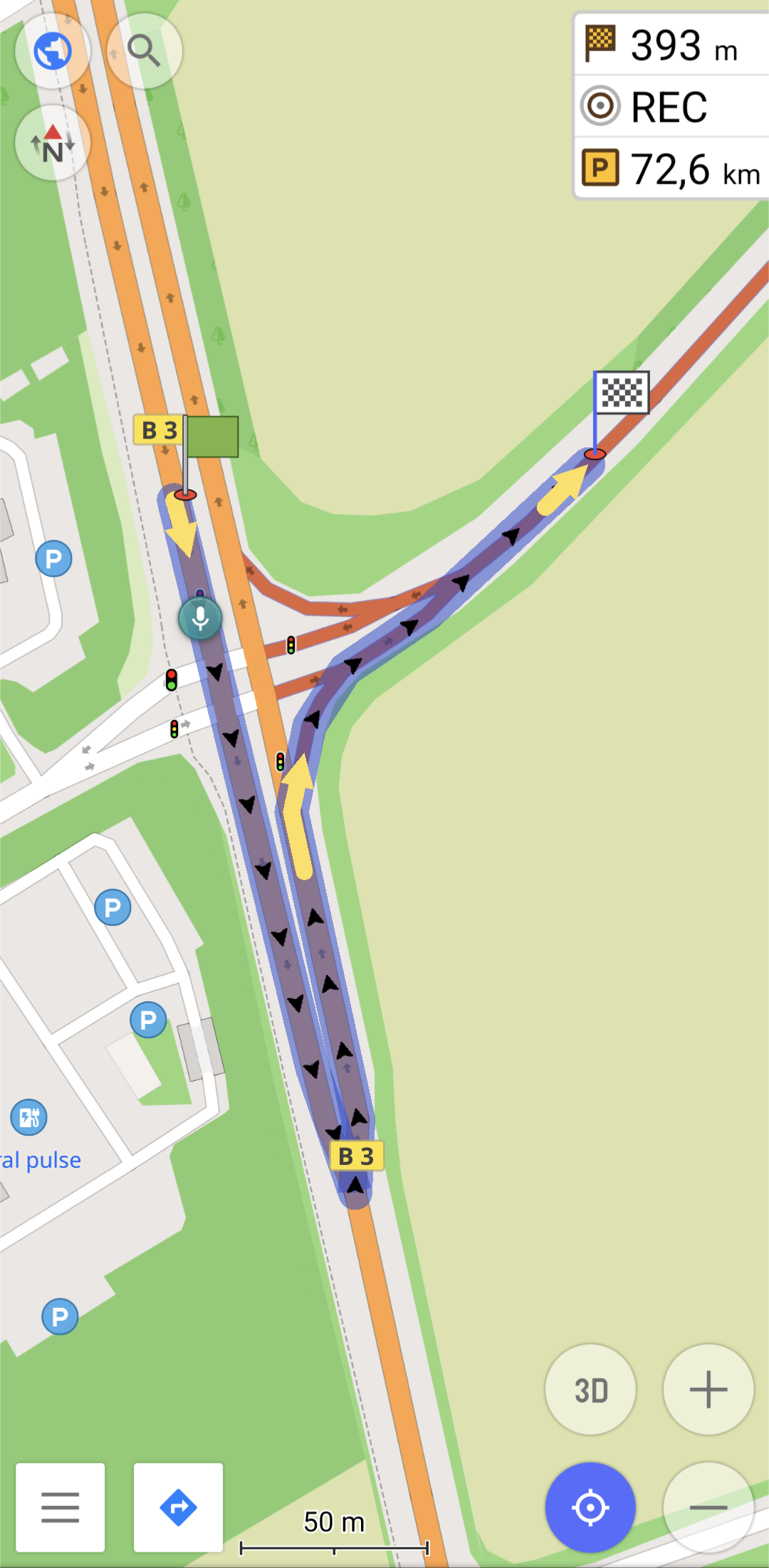
Hey #OpenStreetMap peeps, how can I debug this strange routing behavior?
#GraphHopper & #OSRM make a simple left turn (correct), while #Valhalla and #OsmAnd act as if there's a turn restriction and make a U-turn instead.
This is at 51.73201° N, 9.97389° E, coming from north on B3 and going to the east on A7.
There's been a construction site here a few weeks ago, so my first suspicion was stale data, but even with OsmAnd Live it still does it.
I can't see any restrictions in the data. Ideas?
OSM, Graphopper и все все все
Введение Думаю, все согласятся с утверждением, что в современном мире логистической компании трудно обойтись без маршрутизации. Да, можно планировать все поездки руками, но с ростом объема работ это делать становиться все труднее и труднее. Не спасают ни записные книжки, ни электронные таблицы, ни даже записи в базе данных. Увеличивается количество ошибок. И появляется случаи доставки отправления не в назначенный Саратов, а в Норильск. Выясняется это уже на месте, производится возврат отправления на что тратятся ресурсы компании. Маршрутизация, волшебное слово, но с чего начать?
Go from a forecasted demand to optimized routes. Follow this step-by-step tutorial to create, customize, and test decision apps for logistics using OR-Tools, HiGHS, and more: https://www.nextmv.io/blog/link-and-test-logistics-models-for-demand-forecasting-shift-scheduling-and-vehicle-routing
#osrm #decisionscience #datascience #decisionops #optimization #logistics
Actually, you can : https://openstreetmap.org/directions though it won't be able to provide you with turn-by-turn guidance.
There are multiple routers and modes available, too: #OSRM, #graphHopper, #valhalla
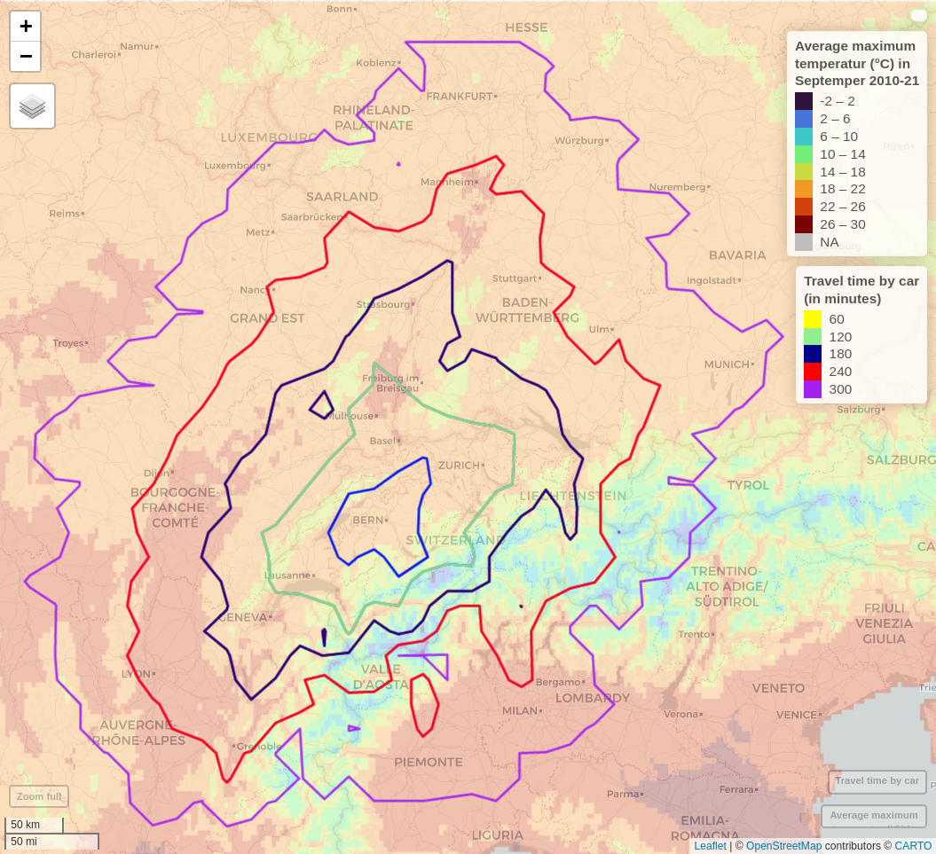
This map can be exported to an interactive html file, so you can zoom in on the map. If anyone is interested I can create one of them for your location. Just leave me a note.
Climate data: https://worldclim.org/data/monthlywth.html
Data processing: #rstats + #rstudio
- Travel-time isochrones: #osrm package
- Visualisation: #mapview package
Basemap: #openstreetmap
One way I am often stuck is by not knowing what to choose when there's too many options. So when we were looking for a little getaway in September I used my #geospatial data analysis skills to find a destination.
In the background is the av. maximum temperature in September in 2010-2021, the overlaying circles are travel time by car.
Looking for a place close by that would have warmer weather I used this map to explore options and decide.
1/
@bxl_forever Good to know. Searching for more info, I see the wiki for public_transport=platform refers to a discussion explaining the problem of routing pedestrians through platform areas more in detail: https://github.com/openstreetmap/iD/issues/8760.