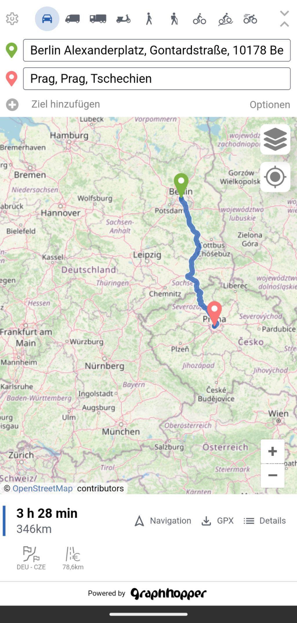
What #OpenStreetMap routing method would you use to draw a reasonably efficient route to visit a number of coordinates (dozens, hundreds of places)?
#OpenRouteService is the only option mentioned in https://wiki.openstreetmap.org/wiki/Track-drawing_websites .
For example: tour of 35 #Helsinki city #libraries. I did the track manually on #GraphHopper and imported it on #uMap. Surely there's a better way?
https://graphhopper.com/maps/?point=60.211976%2C24.899321_Haagan+tori%2C+00320+Helsinki%2C+Manner-Suomi%2C+Suomi&point=60.211892%2C24.891851_Isonnevantie+16%2C+00320+Helsinki%2C+Manner-Suomi%2C+Suomi&point=60.196842%2C24.875807_Munkkiniemen+kirjasto%2C+Riihitie+22%2C+00330+Helsinki%2C+Manner-Suomi%2C+Suomi&point=60.226117%2C24.860429_Pit%C3%A4j%C3%A4nm%C3%A4en+kirjasto%2C+Jousipolku+1+C1%2C+00370+Helsinki%2C+Manner-Suomi%2C+Suomi&point=60.232278%2C24.886046_Kaupintie+4%2C+00440+Helsinki%2C+Manner-Suomi%2C+Suomi&point=60.238828%2C24.876173_Kanneltalo%2C+Klaneettitie+5%2C+00420+Helsinki%2C+Manner-Suomi%2C+Suomi&point=60.24641%2C24.860333_Malminkartanon+kirjasto%2C+Puustellintie+6%2C+00410+Helsinki%2C+Manner-Suomi%2C+Suomi&point=60.249305%2C24.941267_Palohein%C3%A4n+kirjasto%2C+Palohein%C3%A4ntie+22%2C+00670+Helsinki%2C+Manner-Suomi%2C+Suomi&point=60.231191%2C24.933162_Maunulan+kirjasto%2C+Mets%C3%A4purontie+4%2C+00630+Helsinki%2C+Manner-Suomi%2C+Suomi&point=60.227988%2C24.962491_Kyl%C3%A4nvanhimmantie+27%2C+00640+Helsinki%2C+Manner-Suomi%2C+Suomi&point=60.210845%2C24.947109_K%C3%A4pyl%C3%A4n+kirjasto%2C+V%C3%A4in%C3%B6l%C3%A4nkatu+5%2C+00610+Helsinki%2C+Manner-Suomi%2C+Suomi&point=60.20931%2C24.977825_H%C3%A4meentie+135%2C+00560+Helsinki%2C+Manner-Suomi%2C+Suomi&point=60.227515%2C25.01288_Infokeskus+Korona%2C+Viikinkaari+11%2C+00790+Helsinki%2C+Manner-Suomi%2C+Suomi&point=60.2498%2C24.99122_Pukinm%C3%A4en+kirjasto%2C+Kentt%C3%A4kuja+12%2C+00720+Helsinki%2C+Manner-Suomi%2C+Suomi&point=60.250265%2C25.014819_Malmin+kirjasto%2C+Ala-Malmin+tori+1%2C+00700+Helsinki%2C+Manner-Suomi%2C+Suomi&point=60.265566%2C25.019094_Tapanilan+kirjasto%2C+Hiidenkiventie+21%2C+00730+Helsinki%2C+Manner-Suomi%2C+Suomi&point=60.276121%2C25.004456_Suutarilan+kirjasto%2C+Vaskiniitynkuja+5C%2C+00740+Helsinki%2C+Manner-Suomi%2C+Suomi&point=60.274555%2C25.033988_Ajurinaukio+5%2C+00750+Helsinki%2C+Manner-Suomi%2C+Suomi&point=60.271422%2C25.058756_Nurkkatie+2%2C+00760+Helsinki%2C+Manner-Suomi%2C+Suomi&point=60.260506%2C25.076276_Jakom%C3%A4en+kirjasto%2C+Jakom%C3%A4enpolku+3%2C+00770+Helsinki%2C+Manner-Suomi%2C+Suomi&point=60.237708%2C25.085237_Ostostie+4%2C+00940+Helsinki%2C+Manner-Suomi%2C+Suomi&point=60.224182%2C25.072526_Kiviparintie+2%2C+00920+Helsinki%2C+Manner-Suomi%2C+Suomi&point=60.211928%2C25.080165_It%C3%A4keskuksen+kirjasto%2C+Turunlinnantie+1%2C+00900+Helsinki%2C+Manner-Suomi%2C+Suomi&point=60.208802%2C25.143585_Vuosaaren+kirjasto%2C+Mosaiikkitori+2%2C+00980+Helsinki%2C+Manner-Suomi%2C+Suomi&point=60.194521%2C25.052814_Roihuvuoren+kirjasto%2C+Roihuvuorentie+2%2C+00820+Helsinki%2C+Manner-Suomi%2C+Suomi&point=60.179617%2C25.051353&point=60.195079%2C25.033528_Herttoniemen+kirjasto%2C+Linnanrakentajantie+2%2C+00880+Helsinki%2C+Manner-Suomi%2C+Suomi&point=60.18731%2C24.980518&point=60.192129%2C24.962442&point=60.183607%2C24.953627_Kallion+kirjasto%2C+Viides+linja+11%2C+00530+Helsinki%2C+Manner-Suomi%2C+Suomi&point=60.17394%2C24.937982_Helsingin+keskustakirjasto+Oodi%2C+T%C3%B6%C3%B6l%C3%B6nlahdenkatu+4%2C+00100+Helsinki%2C+Manner-Suomi%2C+Suomi&point=60.166128%2C24.94627_Rikhardinkatu+3%2C+00130+Helsinki%2C+Manner-Suomi%2C+Suomi&point=60.159987%2C24.920857_J%C3%A4tk%C3%A4saaren+kirjasto%2C+Tyynenmerenkatu+1%2C+00220+Helsinki%2C+Manner-Suomi%2C+Suomi&point=60.158703%2C24.883285_Lauttasaaren+kirjasto%2C+Pajalahdentie+10a+A%2C+00200+Helsinki%2C+Manner-Suomi%2C+Suomi&point=60.183347%2C24.917451_T%C3%B6%C3%B6l%C3%B6n+kirjasto%2C+Topeliuksenkatu+6%2C+00250+Helsinki%2C+Manner-Suomi%2C+Suomi&point=60.200775%2C24.935879_Pasilan+kirjasto%2C+Kellosilta+9%2C+00520+Helsinki%2C+Manner-Suomi%2C+Suomi&point=60.211976%2C24.899321_Haagan+tori%2C+00320+Helsinki%2C+Manner-Suomi%2C+Suomi&profile=racingbike&layer=OpenStreetMap
https://umap.openstreetmap.fr/en/map/helsinki-culture-tour_1191485#12/60.2286/24.8284