#OpenRouteService

HeiGITheigit
2026-03-05

How far is too far to reach a school or clinic?

We built OpenAccessLens, a global, open-source platform measuring physical access to education and healthcare worldwide. Powered by @openstreetmap and , it maps travel-time to essential services so humanitarian orgs, planners, and researchers can act on the gaps.

Open-source. Community-driven. 🌍

👉 heigit.org/a-map-is-better-tha

Michel Stuyts 🌍michelstuyts@fosstodon.org
2026-02-25

The theme of week 8 of #52maps was "Reach". I made a map about how long it would take you to reach the State of the Map 2026 venue on foot. I made the 5 minute interval isochrones using the ORS Tools plugin for #QGIS that uses the #openrouteservice

More info about #52maps can be found on 52maps.org // @52maps

#StateOfTheMap #OpenStreetMap

A map showing the area around the State of the Map 2026 venue in Paris. It shows 5 minute interval isochrones to the venue.
Burgus BirotaebiciBurgos@masto.ai
2026-02-05

Interesante este #OpenRouteService, me gusta la opción de mostrar isocronas con la distancia que se puede recorrer en un viaje 15 min y 30 min, en coche, bici y andando, e incluso en silla de ruedas.

classic-maps.openrouteservice.

Aquí dejo lo que me ha salido con Burgos, centrado en la Plaza Mayor:

#Burgos

captura de un mapa de Open Route Service centrado en la plaza mayor de Burgos, con unas isocronas de un viaje en COCHE de 15 minutos (color verde) y 30 min (color rojo).

Muestra que por las principales carreteras que salen de la ciudad se puede llegar en media hora por ejemplo hasta Lerma. La zona verde, de 15 min, abarca practicamente toda la ciudad.captura de un mapa de Open Route Service centrado en la plaza mayor de Burgos, con unas isocronas de un viaje en BICI de 15 minutos (color verde) y 30 min (color rojo).

La zona en rojo abarca totalmente la ciudad de Burgos y los pueblos del alfoz: Villagonzalo Pedernales, Villalbilla, Cardeñadijo, Quintanadueñas etc.captura de un mapa de Open Route Service centrado en la plaza mayor de Burgos, con unas isocronas de un viaje ANDANDO de 15 minutos (color verde) y 30 min (color rojo)captura de un mapa de Open Route Service centrado en la plaza mayor de Burgos, con unas isocronas de un viaje EN SILLA DE RUEDAS de 15 minutos (color verde) y 30 min (color rojo)
HeiGITheigit
2026-02-05

🚴 How bike friendly is your city, really?

A new BIKE Index compares cycling conditions across European cities using data from and open source tools. By simulating 210 cycling routes per city with , the study reveals clear differences in how well city networks support bike travel.
The Index show where cycling works well & where infrastructure slows riders down, highlighting how -source tools turn maps into actionable insights.

🔗 tinyurl.com/2jxpa2ja

HeiGITheigit
2025-12-08

How can dynamic data save lives in humanitarian crises?

When bridges collapse or floods cut critical roads, static routing becomes outdated fast, slowing down relief.

Together with Logistics Cluster, we’re developing dynamic routing that integrates real-time, mission-specific data directly into route calculations, helping responders adapt on the fly and avoid delays.

👉 Read more: heigit.org/rethinking-humanita

The image features a group photo with our partners from the Logistics Cluster in Rome and a first prototype of the dynamic routing integrated into LogEI platform.
2025-11-26
2025-11-04

Heute wurde eine neue Version von uMap veröffentlicht. Sie ist bereits auf umap.openstreetmap.de/ verfügbar.

Changelog: github.com/umap-project/umap/r

#openrouteservice ist nun integriert und man kann jetzt online gleichzeitig, gemeinsam an einer uMap arbeiten. Das Feature heißt "Echtzeit-Zusammenarbeit"

#fossgis #uMap #OpenStreetMap

Der Screenshot zeigt das Settings-Menu bei der die Option Echtzeit-Zusammenarbeit aktiv ist und in der uMap-Menüleiste ist ein Symbol zu sehen, welches einen Bearbeiter anzeigt.
2025-09-14

@fellas4europe
@piraten_muc @Just_a_fella_EU

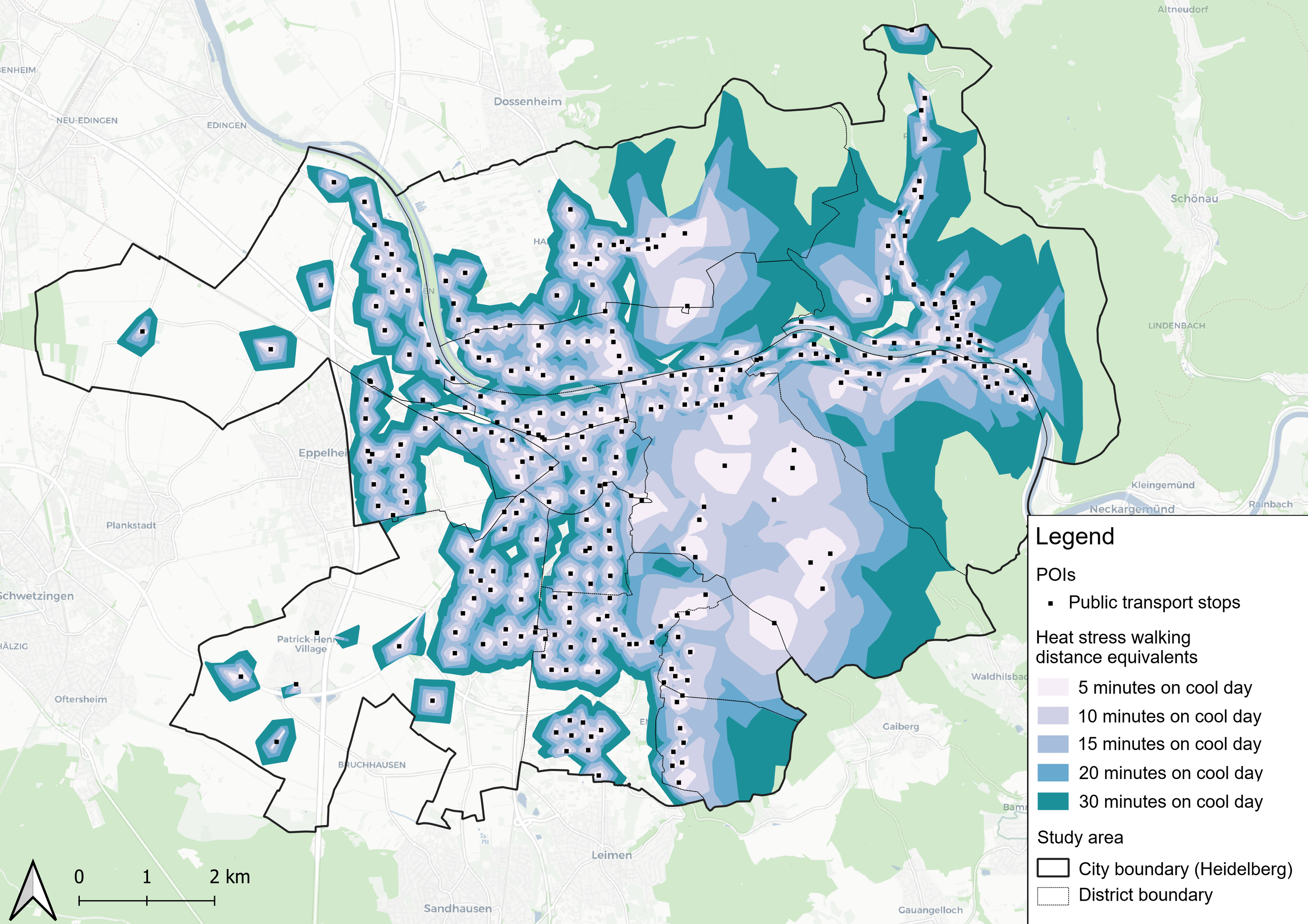
Ja, es ist geschafft! Das zweite Deutsche Battallion der 69th Sniffing Brigade ist aktiv! Bitte helft mit, dass auch diese Kampagne ein Erfolg wird. Besonders freut mich die Ortstafel. Die Entfernung wurde von #openrouteservice berechnet.

help99.co/patches/german-batta

Deutsche Übersetzung:

Ȇber die Kampagne

Wir sind stolz darauf, das Deutsche Bataillon ins Leben zu rufen - eine Kampagne, die ausschließlich den Unterstützern in Deutschland gewidmet ist, die in einer kritischen Zeit an der Seite der Ukraine stehen.

Unser Ziel: Lieferung von einem NAFO Truck 3.0 an eine ukrainische Brigade an der Front. Diese Lastwagen sind lebenswichtig. Jeder von ihnen kann bis zu 50 Menschenleben retten, indem er schnelle Evakuierungen ermöglicht, wichtige Vorräte transportiert und die Verteidiger unter gefährlichen Bedingungen mobil hält.

Trucks sind die Lebensadern des Schlachtfelds - sie bringen Verwundete in Sicherheit, liefern lebenswichtige Ausrüstung und helfen ganzen Einheiten, sich unter Beschuss schnell neu zu positionieren.

Mit Ihrer Unterstützung können wir ein weiteres lebensrettendes Fahrzeug auf die Straße bringen.

Als Dankeschön erhält jeder Spender, der 100 € oder mehr spendet, einen Limited Edition German Battalion Patch - eigens für diese Kampagne als Symbol der Solidarität und Aktion kreiert.

Jedes Land kann etwas bewirken - ein Lkw nach dem anderen.

Warum NAFO-LKWs wichtig sind:
Ukrainische Soldaten kennen den immensen Wert unserer NAFO-LKWs und -Busse. Diese Fahrzeuge werden sorgfältig ausgewählt und zwischen 2011 und 2019 produziert, um die Zuverlässigkeit im rauen Gelände an der Front zu gewährleisten. Jeder Lkw ist in der Lage, mindestens 20.000 km (12.500 Meilen) ohne größere technische Probleme zu fahren, was sie zu einer Lebensader für Soldaten in Kampfgebieten macht.

NAFO Truck 3.0 beinhaltet:

FPV-Drohne Frequenzen Scanner..
Anti-Schlamm-Reifen für den Einsatz in schwierigem Gelände.
Zwei integrierte Drohnenstörsender, die in der Lage sind, Drohnen in einem Radius von 50-100 m zu neutralisieren und zwei wichtige Frequenzlinien abzudecken.

Diese Innovation gewährleistet nicht nur die Sicherheit des Lastwagens, sondern unterstützt auch die Soldaten an der Front, steigert ihre Effizienz und rettet Leben.«

#Ukraine #Ukrainehilfe #supportUkraine #HelpUkraine #NAFO #NAFOfellas #69thSniffingBrigade #HELP99

HeiGITheigit
2025-07-21

𝗨𝘀𝗲-𝗖𝗮𝘀𝗲: 𝗠𝗲𝗮𝘀𝘂𝗿𝗶𝗻𝗴 𝗰𝗶𝘁𝘆 𝘄𝗮𝗹𝗸𝗮𝗯𝗶𝗹𝗶𝘁𝘆 𝘄𝗶𝘁𝗵 𝗼𝗽𝗲𝗻𝗿𝗼𝘂𝘁𝗲𝘀𝗲𝗿𝘃𝗶𝗰𝗲👣🗺️
A recent study by the DC Office of the Chief Technology Officer explores how well residents in Washington, DC can access essential public resources by foot. The isochrones analysis was based on our routing tool openrouteservice. The isochrones were generated using the openrouteservice API, which calculates walking catchment areas around public assets.
More: heigit.org/use-case-measuring-

HeiGITheigit
2025-07-18

📱🗺️ 𝗤𝗚𝗜𝗦 users can now integrate 𝗼𝗽𝗲𝗻𝗿𝗼𝘂𝘁𝗲𝘀𝗲𝗿𝘃𝗶𝗰𝗲 also in the mobile app 𝗤𝗙𝗶𝗲𝗹𝗱.

Thanks to the release of a new plugin, all main functions of openrouteservice can be used in QField, such as generating routes for different means of transport profiles.

The first basic version of the plugin, developed by HeiGIT in collaboration with OPENGIS.ch, can be found here: github.com/GIScience/qfield-or

HeiGITheigit
2025-06-25

𝗥𝗲𝗹𝗲𝗮𝘀𝗲 𝗼𝗳 𝗤𝗚𝗜𝗦 𝗽𝗹𝘂𝗴𝗶𝗻 𝗢𝗥𝗦𝗧𝗼𝗼𝗹𝘀 𝘃.𝟮.𝟬.𝟬🗺️
With ORSTools, most of the functionalities of are directly accessible in . The new ORSTools 2.0.0 version introduces several significant improvements.
Now, it is fully compatible with the upcoming QT6 changes & allows users to drag-and-drop vertex markers on the map.
ORSTools 2.0.0 was presented at the latest QGIS User Conference in Norrköping, Sweden.
Read more: heigit.org/release-of-qgis-plu

2025-06-20

@Armavica @Ragon2 quoi de mieux que de préparer ses traces avec openroute services, les importer dans Umap. Trouver ces points d’intérêts , les poser dans Umap. Et ensuite télécharger le tout en GPX. Et alors là, l’importer dans Organic Map ou maintenant Comaps pour avoir le tout au creux de sa main dans son téléphone, même s’il n’y a pas d’internet.
#organicmap
#CoMaps
#openstreetmap
#umaps
#openrouteservice

HeiGITheigit
2025-06-16

🥵🚶How far can we really walk in a heatwave?

A study by Huber et al. assesses how solar exposure and heat stress impact pedestrian access to essential services in Heidelberg, using data and a customized routing engine.

Results: Nearly one in four citizens loses access to essential services during high heat stress.

Pedestrians in can identify cooler, safer routes using the app: heal.openrouteservice.org/

🔎 Read more: heigit.org/new-paper-accessibi

Map og Heidleberg showing "heat stress walking distance equivalents"
2025-06-03

To calculate how NO2 concentration might affect the population, we finally chose to calculate isochrones (5-minute walk) from the measurements. For this, we used #openrouteservice in an R environment. We then used #QGIS to create the final maps.
Does anyone have another approach?
#datascience #GISChat #RStats #airpollution

2025-04-21

Aus aktuellem Anlass: Planung einer Wanderung ohne Werbeschleudern, ohne Login, Eckpunkte klicken und verbinden lassen:

maps.openrouteservice.org/

Einzige Voraussetzung: man muss ein wenig Erfahrung haben, wie auf openstreetmap gangbare Wege aussehen, bzw. wie sich das Kartenbild in die Wirklichkeit übersetzt. Aber dass man nicht durch ein Industriegebiet wandern will, oder 3km auf einem Fahrweg direkt neben der Autobahn, das weiß man doch, oder?

#openstreetmap #openrouteservice #wandern

Nemo_bis 🌈nemobis@mamot.fr
2025-03-15

What #OpenStreetMap routing method would you use to draw a reasonably efficient route to visit a number of coordinates (dozens, hundreds of places)?

#OpenRouteService is the only option mentioned in wiki.openstreetmap.org/wiki/Tr .

For example: tour of 35 #Helsinki city #libraries. I did the track manually on #GraphHopper and imported it on #uMap. Surely there's a better way?
graphhopper.com/maps/?point=60
umap.openstreetmap.fr/en/map/h

35 Helsinki libraries on uMap35 Helsinki libraries on GraphHopper
2025-02-18

#openrouteservice (ORS) has been growing steadily, and we are thrilled to see how it is being used for meaningful purposes, from humanitarian logistics to sustainable transportation and beyond.
Here are some metrics on its impact in the last year ⬇️

🔗 Access ORS: openrouteservice.org/

#OpenStreetMap #OpenData

2025-02-14

For QGIS users:
Learn how to create isochrones in QGIS with the ORS plugin with this 1-minute video tutorial by @felt : youtube.com/watch?v=aRlCy-jfZb

The openrouteservice (ORS): openrouteservice.org/

#QGIS #ORS #openrouteservice #OpenStreetMap

Client Info

Server: https://mastodon.social
Version: 2025.07
Repository: https://github.com/cyevgeniy/lmst