#GoogleMaps Alternatives (Navigation & Mapping) continued…
4. #ArcGIS Earth (by Esri) – A professional-grade #GIS tool with 3D #mapping.
5. #SentinelHub – Provides access to high-resolution satellite imagery (Sentinel-2, Landsat).
6. #ZoomEarth – A browser-based map with near real-time satellite images.
#SentinelHub
https://eos.com/blog/free-satellite-imagery-sources/
@KaterynaSergieieva
#EarthObservation #EO #SatelliteImagery #HighResolution #USGSEarthExplorer #EarthExplorer #LandViewer #EOSDALandViewer @CopernicusEU #SentinelHub #EOBrowser #EarthdataSearch #NASAEarthdataSearch #INPEImageCatalog #ImageCatalog #GoogleEarth #DataAccessViewer #NOAADataAccessViewer #ZoomEarth #Maxar #NASAWorldview #Worldview #VITOVision #UNAVCO #Bhuvan #EOSDataAnalytics
@hareldan According to https://wiki.openstreetmap.org/wiki/Sentinel-2, #Sentinel2 #satelliteImagery can already be used in OSM editors, but not as easily as other sources, as it isn't pre-configured, so users have to configure it themselves.
The main issue for pre-configuring it is probably that WMS/WMTS URLs are personalized and a user sign-up at #SentinelHub is required.
No free usage of @sentinel_hub anymore? @sinergise published a blog on moving from Sentinel Hub to Copernicus Browser. They said Copernicus Browser offers the same intuitive functionality as Sentinel Hub EO Browser, but is easier to use and free long-term.
https://medium.com/sentinel-hub/transition-guide-from-sentinel-hub-eo-browser-to-copernicus-browser-6c2b49e24da6
To me, this reads like #SentinelHub will become a paid service for commercial customers. Probably not a big deal, as #CDSE remains free, but an interesting development.
What do you think?
RT by @CopernicusEU: 🔵👀 A new series of tutorial 🎞️ videos on how to access the #SentinelHub APIs in your @CopernicusEU Data Space Ecosystem #JupyterLab using #Python. Learn how to configure your credentials, search, visualise Sentinel-2 🖼️ & create time series analyses.
▶️ https://youtube.com/playlist?list=PLj4KwRQTBlPL3CVwpaBXl3VrO0_V3VX_Q&si=nTHxQ_Frh7T-X5GS
🐦🔗: https://nitter.cz/sentinel_hub/status/1750872557853589798#m
[2024-01-26 13:25 UTC]
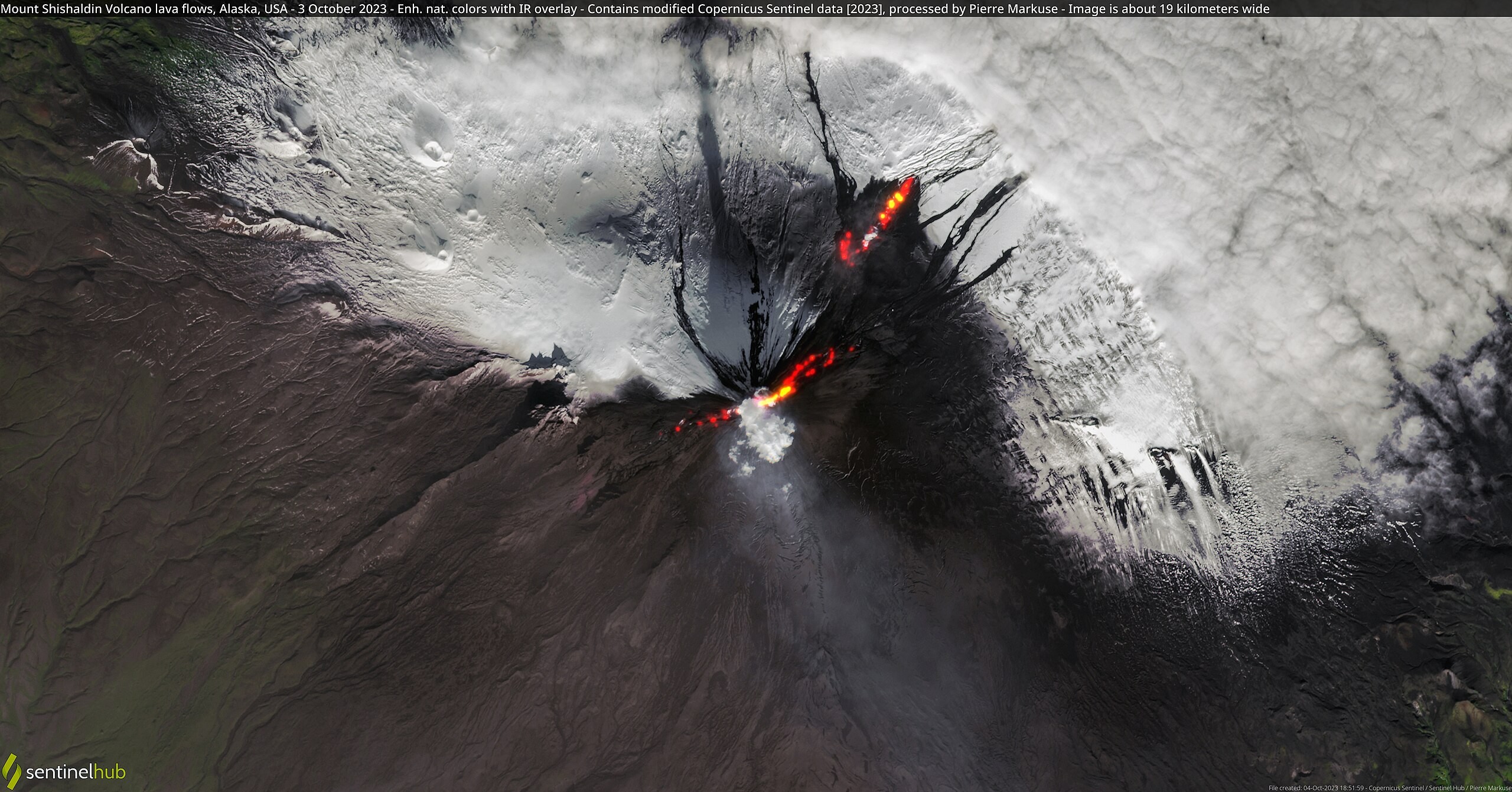
Mount Shishaldin Volcano lava flows, Alaska, USA - 3 October 2023 🌍🛰️
#alaska #eruption #landscape #lavaflow #mountshishaldin #sentinel #sentinel2 #sentinelhub
▶️ 1 new picture from @pierre_markuse https://commons.wikimedia.org/wiki/File:Mount_Shishaldin_Volcano_lava_flows%2C_Alaska%2C_USA_-_3_October_2023_%2853234173511%29.jpg
Fires near São Teotónio, Portugal - 7 August 2023 🌍🔥🛰️
#airquality #fire #landscape #portugal #sentinel #sentinel2 #sentinelhub #smoke
▶️ 1 new picture from @pierre_markuse https://commons.wikimedia.org/wiki/File:Fires_near_S%C3%A3o_Teot%C3%B3nio%2C_Portugal_-_7_August_2023_%2853101142100%29.jpg
🌍🛰️ Kilauea Volcano eruption, Hawaii, USA - 11 September 2023
#eruption #hawaii #kilauea #kilaueavolcano #landscape #sentinel #sentinel3 #sentinelhub #space #usa
▶️ 1 new picture from @pierre_markuse https://commons.wikimedia.org/wiki/File:Kilauea_Volcano_eruption%2C_Hawaii%2C_USA_-_11_September_2023_%2853183204138%29.jpg
🌍🛰️ 1 new picture from @pierre_markuse
- Columbia Glacier, Alaska, USA - 22 August 2023
#alaska #columbiaglacier #glacier #ice #landscape #sentinel #sentinel2 #sentinelhub #snow #space
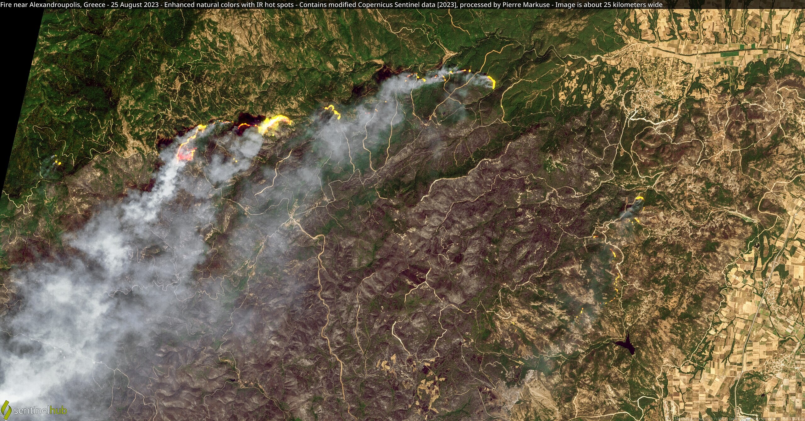
🌍🔥🛰️ 2 new pictures from @pierre_markuse
- alex25_annotated
- alex25b_annotated
#airquality #alexandroupolis #fire #greece #landscape #sentinel #sentinel2 #sentinelhub #smoke #space
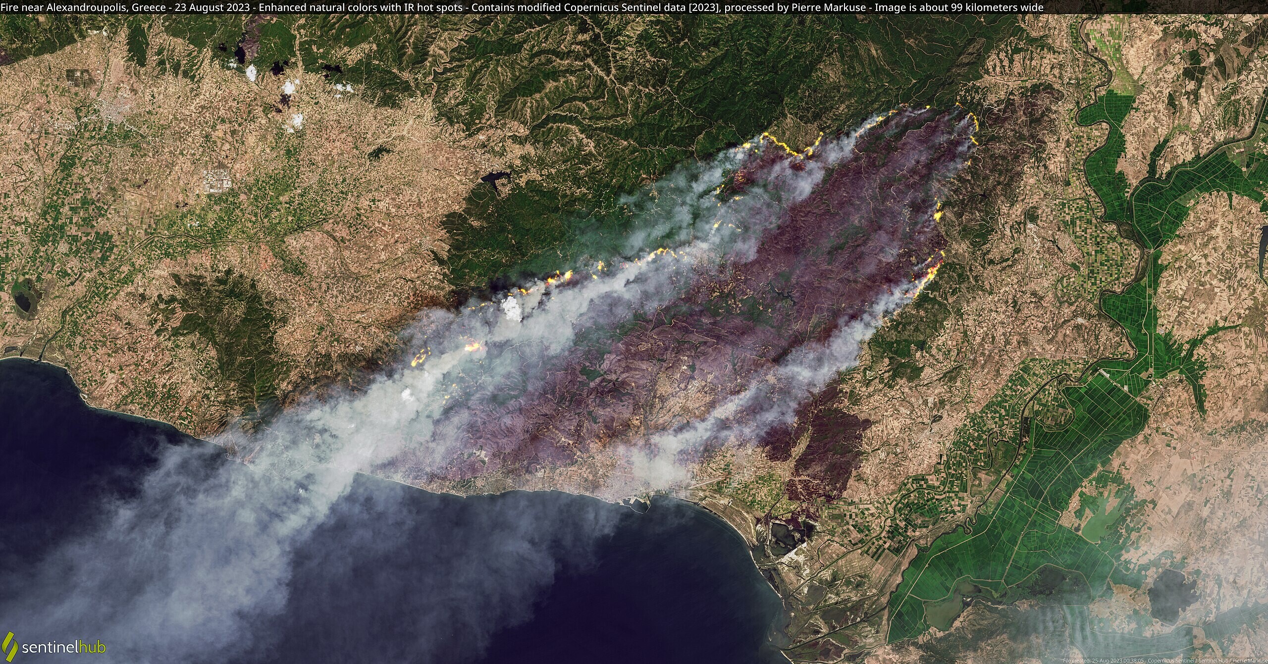
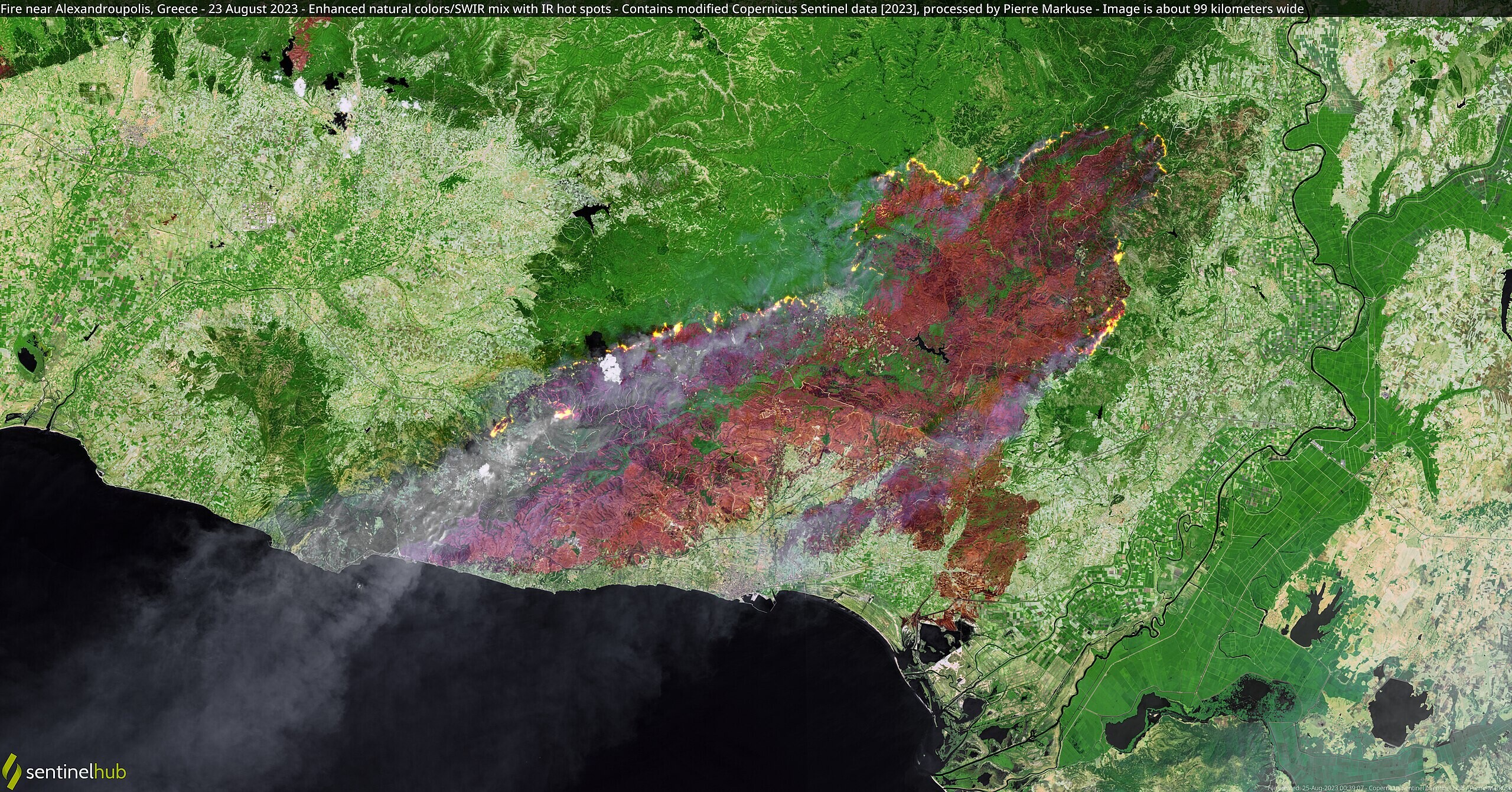
🌍🔥🛰️ 2 new pictures from @pierre_markuse
- Fire near Alexandroupolis, Greece - 23 August 2023
#airquality #alexandroupolis #fire #greece #greecefire #landscape #sentinel #sentinel2 #sentinelhub #smoke
🌍🔥🛰️ 2 new pictures from @pierre_markuse
- Fire near Alexandroupolis, Greece - 22 August 2023
#airquality #alexandroupolis #fire #greece #greecefires #landsat #landsat7 #landscape #sentinelhub #smoke
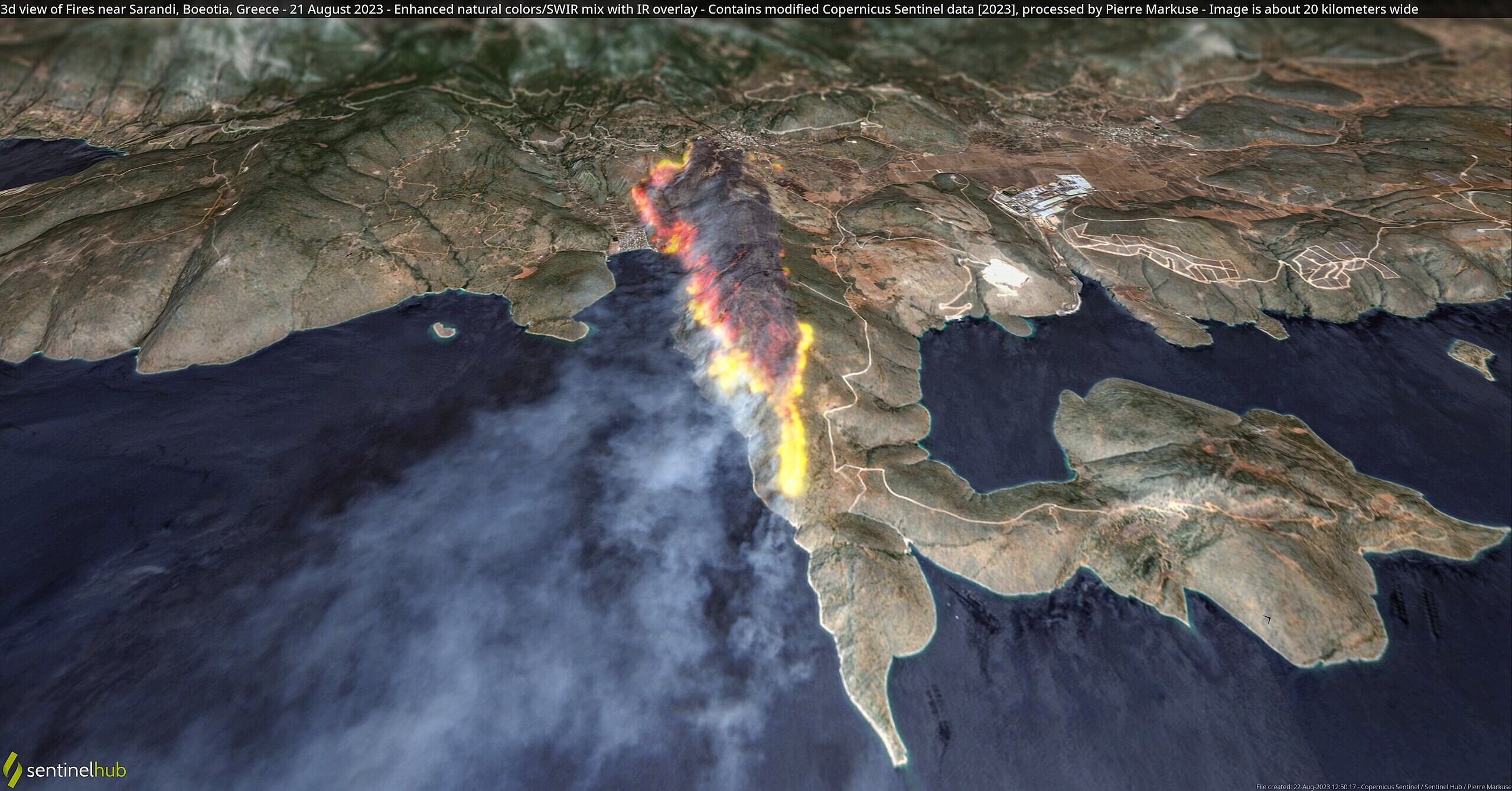
🌍🔥🛰️ 1 new picture from @pierre_markuse
- 3d view of Fires near Sarandi, Boeotia, Greece - 21 August 2023
#3d #boeotia #fire #greece #landscape #sarandi #sentinel #sentinel2 #sentinelhub #smoke
🌍🔥🛰️ 1 new picture from @pierre_markuse
- Fires and smoke on Tenerife, Spain - 16 August 2023
#fire #island #landscape #sentinel #sentinel2 #sentinel3 #sentinelhub #smoke #space #spain
And this is closer to what it actually looks like on the ground (from the 30th July - there is currently cloud over the area) - image here taken from #ESA's #Sentinel2 mission - which is one of the BEST things that has ever happened in #EarthObservation, processed on #SentinelHub's #EOBrowser - which is maybe the 2nd best..
2/2

🌍🛰️ 1 new picture from @pierre_markuse
- Eye of Typhoon Khanum near Okinawa, Japan - 2 August 2023
#clouds #japan #khanum #landscape #okinawa #sentinel #sentinel2 #sentinelhub #space #storm
🌍🔥🛰️ 1 new picture from @pierre_markuse
- York Fire, Mojave National Preserve, California, USA - 29 July 2023
#calfire #california #fire #landscape #mojavedesert #mojavenationalpreserve #sentinel #sentinel2 #sentinelhub #smoke
🌍🔥🛰️ 2 new pictures from @pierre_markuse
- Fires on Rhodes, Greece - 26 July 2023
#airquality #fire #greece #landsat #landsat8 #landscape #rhodes #rhodos #sentinelhub #smoke
Neat, the "moisture index" visualization on #SentinelHub has the side effect of showing #smoke over the ocean in blue in great detail (smoke from Rhodes, Greece, heading out into the Mediterranean) #satellite #imaging
🌍🔥🛰️ 4 new pictures from @pierre_markuse
« Fires on Rhodes, Greece - 23 July 2023 »
« rhodes3d2_annotated »
« rhodes3d_annotated »
#3d #fire #greece #island #landscape #rhodes #rhodos #sentinel #sentinel2 #sentinelhub
Client Info
Server: https://mastodon.social
Version: 2025.04
Repository: https://github.com/cyevgeniy/lmst