#dewpoints

2025-06-18

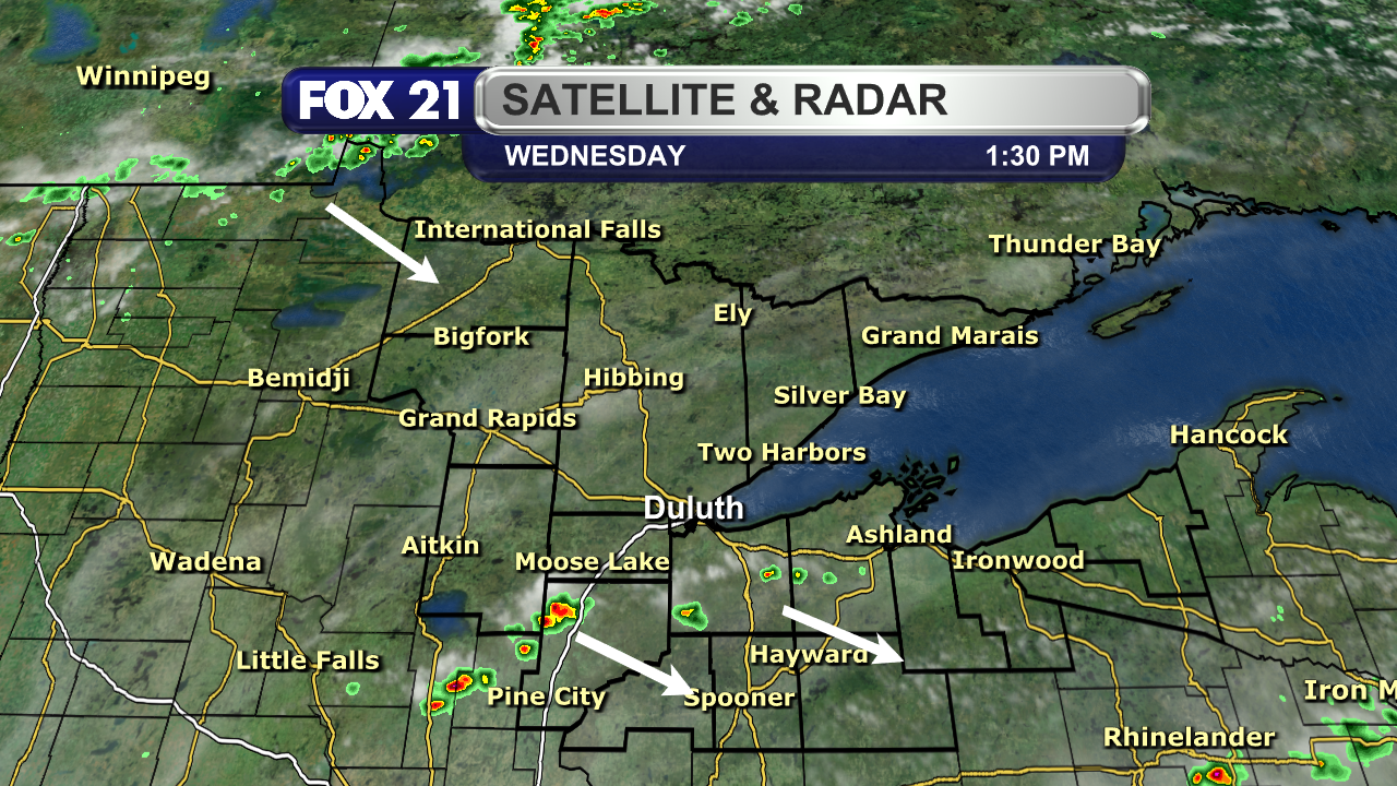
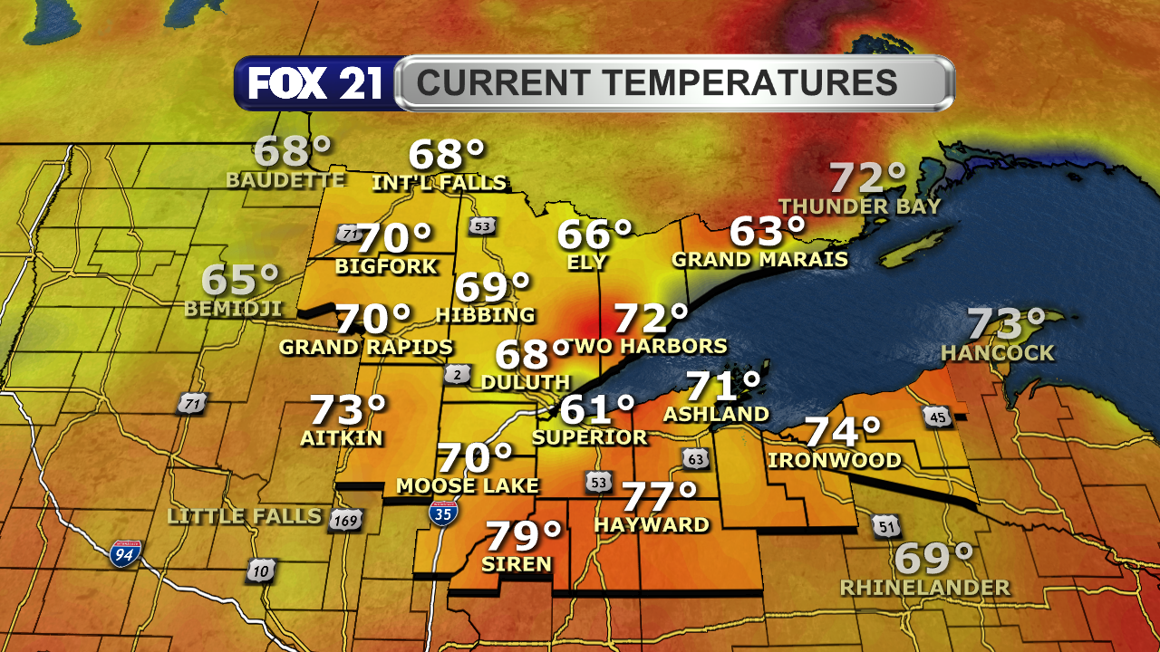
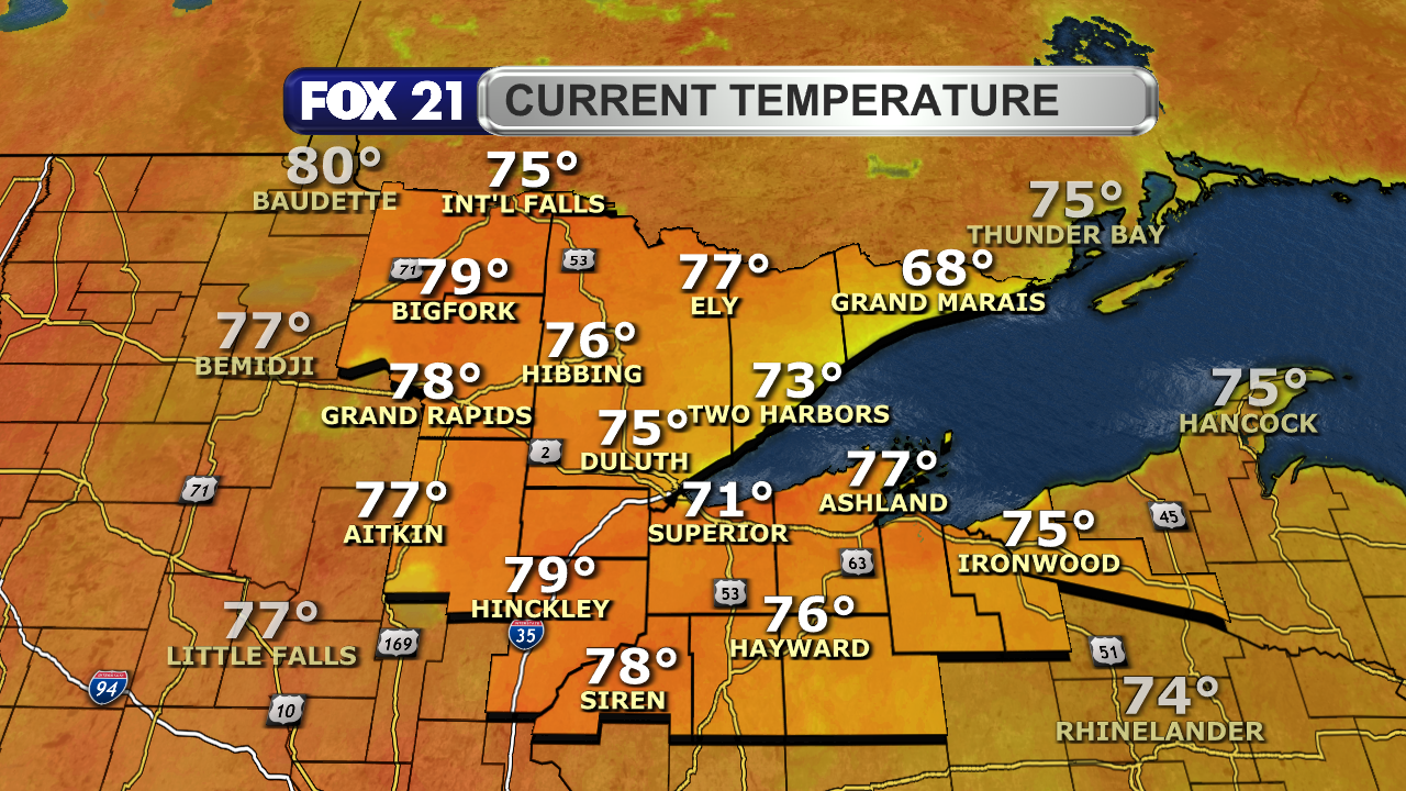
Happy #Wednesday afternoon from the #Northland!

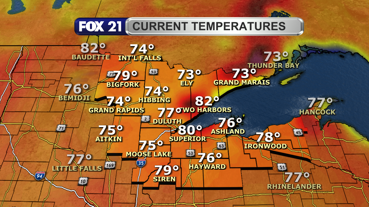
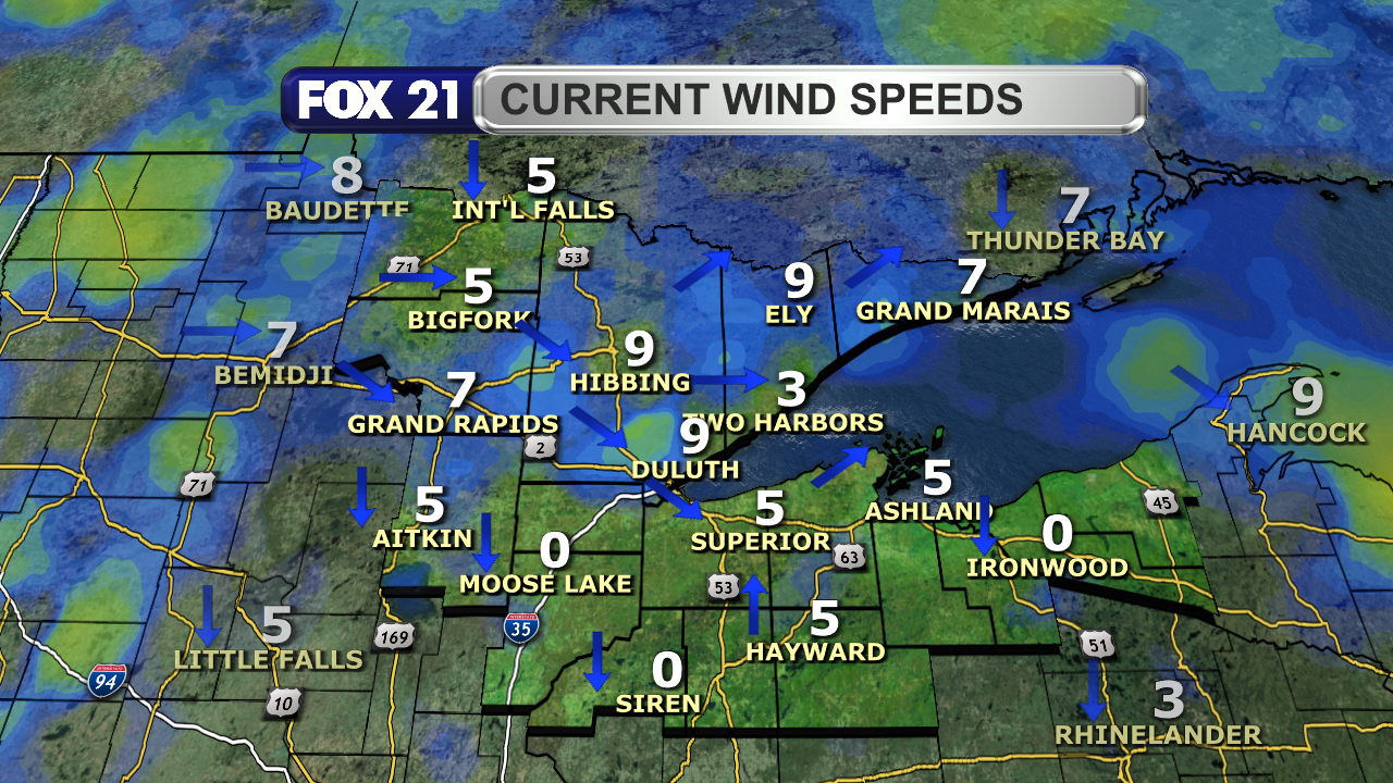
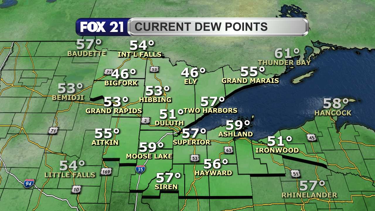
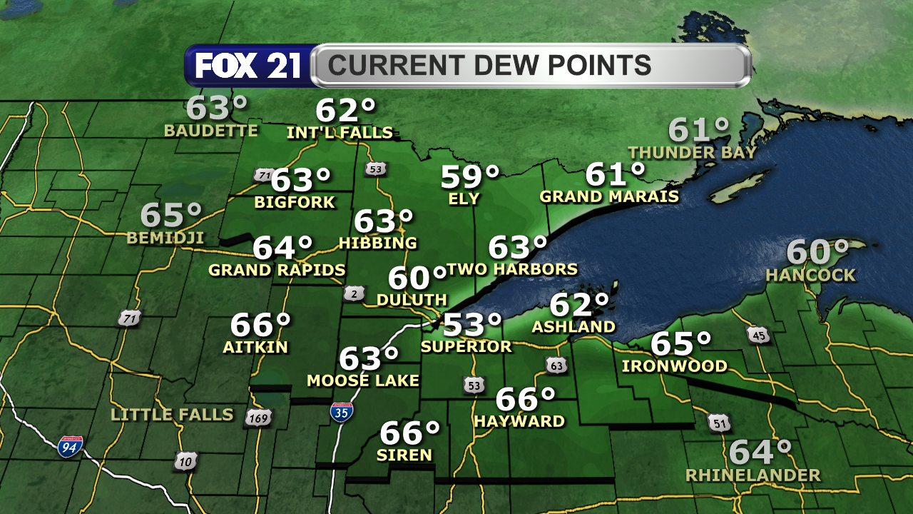
It's another #summer-like #weather day in the region with #warm #temperatures, light #winds, and comfortable #dewpoints.

The sky is a mix of #sunshine and #clouds, with a few lines of pop-up #showers forming and passing through.

#wxtooter #wx #MNwx #WIwx #UPwx

The satellite and radar over the Northland at 1:30 p.m. on Wednesday, June 18, 2025, shows a mix of sunshine and clouds.  A line of scattered pop-up showers has formed in the I-35 corridor and northwest Wisconsin from Ashland west/southwest to Pine City, moving to the east/southeast.  Another mostly solid line of showers is expected to push into Koochiching County later this afternoon.Temperatures in the Northland just after 1 p.m. on June 18, 2025, range from 73 to 82 degrees Fahrenheit.Wind speeds in the Northland just after 1 p.m. on June 18, 2025, range from calm to 9 mph.  Wind direction is primarily from the northwest and north.Dew point readings across the Northland just after 1 p.m. on June 18, 2025, range from 46 to 59 degrees Fahrenheit.
2025-06-16

Happy #Monday afternoon from the #Northland!

It's is feeling more like #summer in the region thanks to higher #dewpoints and warmer #temperatures.

However, that will allow strong and #severe #thunderstorms to form and pass through the rest of today. Greatest threats are large #hail and high #winds. A weak #tornado is also possible.

#wxtooter #weather #wx #MNwx #WIwx #UPwx

The Storm Prediction Center has placed the I-35 Corridor in an Enhanced Risk for severe weather for the rest of Monday, June 16, 2025.  The vast majority of the Northland is under a Slight Risk, with the regions near the Canadian border and the Upper Peninsula in a Marginal Risk.  The greatest threat from the strongest thunderstorms that will pass through the rest of Monday are hail over 2" in diameter and wind gusts over 60 mph.  A weak tornado and minor flash flooding is also possible.The satellite and radar over Minnesota and the Northland at 1:30 p.m. on Monday, June 16, 2025, shows a scattering of showers and a few thunderstorms over the western half of the Northland, with a mix of clouds and clear skies over northwest Wisconsin and the Upper Peninsula.  A clearing of cloud cover over central Minnesota is being observed, and the focal point for the development of strong and severe thunderstorms that will pass through our region later today.Temperatures in the Northland just after 1 p.m. on June 16, 2025, range from 61 to 79 degrees Fahrenheit.Dew point readings across the Northland just after 1 p.m. on June 16, 2025, range from 53 to 66 degrees Fahrenheit.  Most locations are in the humid range in the 60s.
2024-07-09

Happy #Tuesday afternoon from the #Northland!

It's another #summer-like #weather day for the region with plenty of #sunshine, light #winds, #warm #temperatures, and decent #dewpoints.

A few #pop-up #showers and #thunderstorms are starting to form, but not as many as the past several days.

#wxtooter #wx #MNwx #WIwx #UPwx

The satellite and radar over the Northland at 2 p.m. on Tuesday, July 9, 2024, shows mostly clear skies across the region.  A few small clusters of pop-up showers are forming in the I-35 corridor.Temperatures in the Northland around 2 p.m. on July 9, 2024, range from 77 to 83 degrees.Dew point levels in the Northland around 2 p.m. on July 9, 2024, range from 36 to 63 degrees.  Most locations are in the upper 50s and low 60s.Wildfire smoke continues to flow into the western Great Lakes region from northwest Canada around a couple high-pressure systems in the western United States.  While smoke levels have increased slightly compared to Monday, air quality levels remain good to moderate in the Northland.
2024-06-16

Happy #Sunday afternoon from the #Northland!

It is feeling like #summer in the region with #temperatures warming to the 70s and 80s and #dewpoints in the 60s.

Unfortunately, this will allow scattered #showers and #thunderstorms to form and pass through the rest of today.

The #severe #weather threat is increasing, with large #hail and high #winds the biggest concern.

#wxtooter #wx #MNwx #WIwx #UPwx

The satellite and radar over the Northland at 2 p.m. on Sunday, June 16, 2024, shows a scattering of clouds over most of the region, with some clear skies in parts of the South Shore and the Arrowhead.  Some showers and thunderstorms are trying to develop in the Rainy River Basin, moving from southwest to northeast.The Storm Prediction Center has placed the entire Northland in a Slight Risk for severe weather through for Sunday.  The greatest threat will be hail up to 2-inches in diameter and wind gusts up to an over 60 mph.  Flash flooding is possible with any downpours that occur, as well as the possibility of a weak tornado.Temperatures in the Northland around 2 p.m. on June 16, 2024, range from 57-degrees in Superior (cooled by a lake breeze) to 79-degrees in Siren.  Most locations are in the 70s.Dew point levels in the Northland around 2 p.m. on June 16, 2024, outside of Superior, are in the 60s.
2023-08-31

Happy #Thursday from the #Northland!

The final day of #August will be #warm for this time of the year. An increase in #dewpoints and a southerly #breeze is keeping it feeling like #summer.

Keep an eye to the sky as a broken line of light #showers is passing through along a #front. Some are reaching the ground (#virga) so don't expect much #rain through tonight.

#wx #wxtooter #weather #MNwx #WIwx #UPwx

Temperatures in the Northland around 2:15 p.m. on Thursday, August 31, 2023, range from 68-degrees in Grand Marais to 79-degrees in Hinckley.  Most temperatures are in the mid-70s.Wind speeds in the Northland around 2:15 p.m. on Thursday, August 31, 2023 range from 5 to 15 mph, with the direction coming from the south and southeast.  There is a slight lake breeze along the Lake Superior shoreline.The radar over the Northland at 2:10 p.m. on Thursday, August 31, 2023, shows a thin broken line of showers extending just to the west of the region.  It is moving to the east/northeast, with some of the showers not reaching the ground.
2023-08-28

Happy #Monday from the #Northland!

#Summer isn't over yet as #temperatures and #dewpoints from the heart of the #season have returned.

However, the #clouds have increased as a #cold #front passes through from Canada.

Expect #scattered #showers and a few #thunderstorms through tonight, but none will be severe.

#wxtooter #weather #MNwx #WIwx #UPwx

Temperatures in the Northland just after 2 p.m. on Monday, August 28, 2023 range from 72-degrees in Grand Marais to 82-degrees in Superior.  Most locations are in the upper 70s.Compared to 2 p.m. on Sunday, August 27, 2023, temperatures in the Northland are 5 to 17-degrees warmer on Monday.Current dew points in the Northland just after 2 p.m. on Monday, August 28, 2023, range from 52-degrees in Grand Marais to 64-degrees in Superior.  Most locations are in the low 60s.The satellite and radar over the Northland at 2:15 p.m. on Monday, August 28, 2023 shows some light showers beginning to form west of the Twin Ports and in northern St. Louis counties.  They are expected to become a scattered line of showers and a few thunderstorms, which will pass through from northwest to southeast Monday afternoon and evening.
2023-08-27

Happy #Sunday #Northland!

We are enjoying an "early #fall" #weekend with cooler #temperatures, comfortable #dewpoints, and plenty of #sunshine, especially today.

We are monitoring a chance for #showers and a few #thunderstorms for Monday, and a warm up back to #summer-like heat for the #LaborDay weekend.

#wxtooter #weather #MNwx #WIwx #UPwx

High temperatures in the Northland Saturday, August 26, 2023 were in the 60s across the region.  None of the major cities on the map got above 70°.Temperatures in the Northland around 2:30 p.m. on Sunday, August 27, 2023, range from 63-degrees in Grand Marais to 73-degrees in Bigfork.  A majority of the temperatures are around the 70° mark.Wind speeds in the Northland around 2:30 p.m. on Sunday, August 27, 2023, are around 5 to 10 mph from the south, with a light lake breeze happening near Lake Superior.The surface map over the Upper Midwest and the Western Great Lakes around 2:30 p.m. on Sunday, August 27, 2023, shows a high-pressure system over the Great Lakes, with a weak low-pressure system in the Dakotas.  The low is bringing isolated showers along a boundary line behind a warm front.
2023-08-15

NORTHLAND FORECAST FOR AUGUST 16, 2023:

The #Northland will see partly cloudy skies Tuesday night with warm lows and a light #breeze.

#Winds become #windy Wednesday, helping to keep #temperatures #summer-like and increase #dewpoints.

#Showers and #thunderstorms are likely during the afternoon and evening hours. Some could be strong or #severe with high #winds and large #hail.

VIDEO: fox21online.com/2023/08/15/tue

#wxtooter #forecast #MNwx #WIwx #UPwx

2023-08-14

NORTHLAND FORECAST FOR AUGUST 15, 2023:

The #Northland will enjoy a #cool and #clear Monday night with little #wind.

Tuesday will start a #summer-like #weather trend regarding #temperatures and #dewpoints with plenty of #sunshine. There will be a #breeze from the southwest with a possible light #shower in the #Arrowhead region.

VIDEO: fox21online.com/2023/08/14/mon

#wxtooter #forecast #MNwx #WIwx #UPwx

2023-08-10

Happy #Thursday #Northland!

Today is one of those days where I wish I had a patio to work from at the station.

It's ideal late #summer #weather conditions across the Northland. One should never complain about these #temperatures and #dewpoints.

I recommend getting outside and enjoying it, because a much needed stretch of #rain starts tonight.

#wxtooter #MNwx #WIwx #UPwx

jaxwxboss :linux:jaxwxboss@fosstodon.org
2023-08-08

The #weather has been crazy here since late May. Almost every day is greeted with yet another #heatadvisory or excessive heat advisory. Couple that with with #dewpoints in the upper 70’s to low 80’s, the #heatindex continually pushes 100+ degrees.

2023-06-07

Most of the #Northland is #dry, but a few #showers could pass through Koochiching and Itasca County this afternoon.

The rest of the area is dealing with low #dewpoints, leading to higher #fire dangers.

A breeze off #LakeSuperior is keeping the waters choppy around the #TwinPorts. That will last through this evening.

#wxtooter #weather #MNwx #WIwx #UPwx

A view of the radar at 2:25 p.m. at June 7, 2023 shows some showers and thunderstorms close to Koochiching and Itasca counties.  A few showers could sneak into these counties through Wednesday afternoon.Fire dangers in the Northland are very high in parts of the Upper Peninsula, high for the Arrowhead and most of northwest Wisconsin, and moderate for the rest of the region.Due to a breeze coming off Lake Superior, a Beach Hazard Statement is in effect for the Twin Ports region through Wednesday.  A Small Craft Advisory is also in effect for 2 to 4 foot waves.

Client Info

Server: https://mastodon.social
Version: 2025.04
Repository: https://github.com/cyevgeniy/lmst