
@heiseonline Na dann vergleichen wir doch mal mit #OpenStreetMap und #OvertureMaps
(Also ich nicht, fahre gerade ICE)
#overturemaps

#TomTom, Microsoft, Meta (Facebook), Amazon, & others are sharing mapping data as Open Source data in the #OvertureMaps Foundation. Collaboration through shared data sets to help make maps better and more accurate. #OvertureMaps (Note one mapping provider is not participating, #GoogleMaps). #TomTomDiscover


@geonews Do you know if #OvertureMaps #GERS ID are already entering in #OpenStreetMap data ? I would expect so, but I'm not sure what tag to search for. Taginfo counts 61 ref:gers entries, which I find remarkably low: https://taginfo.openstreetmap.org/keys/ref%3Agers.

The #OvertureMaps also contain #OSM building parts now, as ready to use geometries. But not only, also geometries of AI sources are included. No roof shapes, but it may be interesting anyway to inspect their data. There is no Web API to get small regions. There is a #RustLang crate to read the GeoParquet format they use.
Do you use #Overture ? Do you know the URL to get the files? Could you provide a Rust code example? If yes, I would add it to the inputs of "OBI"


@simon @linuxfoundation Does that matter if the processed data is open? You have the choice of using the raw data from #osm or the processed data from #overturemaps which may include other sources as well


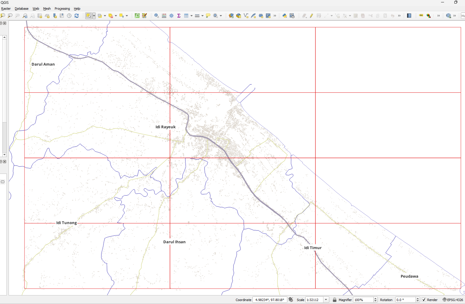
Pro tip for overturemaps building footprint downloads: While the official data download can be tricky, explore.overturemaps.org is a handy alternative (though limited to zoom 15). Need to check multiple areas? Here's a QGIS field calculator hack:
'https://explore.overturemaps.org/#15/' || to_string(y(centroid($geometry)), 5) || '/' || to_string(x(centroid($geometry)), 5)
This generates clickable URLs for each grid cell! 🗺️ #QGIS #OpenData #overturemaps

📢 Making Maps Smarter with Open Data 🌍
The Overture Maps Foundation is transforming how map data is shared & used. With Amy Rose as its first CTO, efforts continue to make mapping more open, accurate & connected.
Learn how open data is shaping the future of maps: 🔗 Read the blog: https://overturemaps.org/blog/2025/making-open-data-part-of-a-national-data-infrastructure/


@aboutgeo Went with clusters in the pmtiles in the end. Here are the gory details: https://github.com/healthyregions/overture-poi-extract/blob/v0.0.1/extract_pois.py#L142 Ultimately, we needed to create #geojson #pmtiles or #shapefile extracts from the #overturemaps "places" theme for groups of categories, filtered just to the US. But I built it so random geoms can be passed in, or you can just provide a state, county, tract, etc. ID and that boundary will be used as a filter.

今年は Overture Mapsのベータ版データを公開されたので、色々と具体的な議論ができる。日本全域の建物数はゼンリン調べの3800万戸からOverture調べで約5000万戸になるんじゃないかとの事で、以前より細かな建物検出ができるようになってきている。
#OvertureMaps #OpenStreetMap #Japan #Brasil #Belem #FOSS4G #sotmlatam #foss4g2024 #PoliMI #GEOlab #FuruhashiLab #古橋研究室 #AoyamaGSC #地球社会共生学部 #青学 #一億総伊能化

ミラノのMetaオフィスで開催された #Mapillary ミートアップイベント「Walkabout Milano」に THETA X を持って登壇してきました。3m 一脚の威力も実演。ミラノ市の都市政策の担当官も登壇されて、我々が収集した都市のストリート画像をどのように行政で活用するのかも知ることができて学ぶことの多いイベントでした。古橋の資料はコメント欄にURL貼ります!
#THETA360 #theta360fan #Meta #OpenStreetMap #OvertureMaps #Milano #GEOlab #PoliMI #FuruhashiLab #古橋研究室 #AoyamaGSC #青学

ついに、ミラノ市内の360°ストリート画像データを #Mapillary にがっつりアップロードしている同志Jacopo Farinaさんと対面!
#Meta #OpenStreetMap #OvertureMaps #Milano #GEOlab #PoliMI #Milano #FuruhashiLab #古橋研究室 #AoyamaGSC #青学

MilanoのMeta Officeにて #Mapillary meetup “Walkabout Milano” 始まった!この後古橋も登壇します!
#Meta #OpenStreetMap #OvertureMaps #Milano #GEOlab #PoliMI #Milano #FuruhashiLab #古橋研究室 #AoyamaGSC #青学

Checking in from the #OGC @opengeospatial member meeting in Goyang, South Korea. Here for #DGGS. Side info #OvertureMaps is a principal member now and Bentley has acquired Cesium 3d globe software


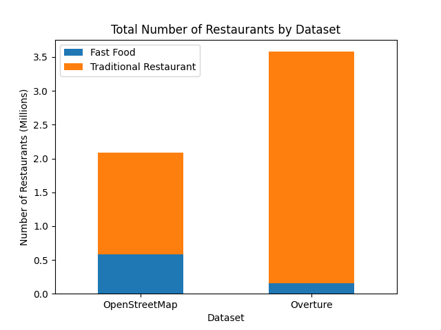
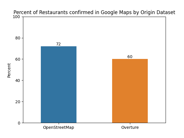
My recent project Surprise Date Spot uses #openstreetmap to find every restaurant across the planet. When I was creating this project I wondered if #overturemaps could provide better data, but didn't find much in the way of quantitative comparison between the two.
So I decided to do my own analysis by looking at 100 random restaurants from each dataset. Here's how they compare:
https://surprisedatespot.com/blog/comparing-overture-osm-restaurants/

The categories for 2024’s #30DayMapChallenge are finally out!
https://30daymapchallenge.com/
It seems the categories depart just a little bit more from the usual types of challenges in past years.
3 categories give me some pause though: “AI only” (day 9), “Collaborative map” (day 17), and “Overture” (day 29). I’ll probably do an anti-AI map for day 9. Day 17 won’t be smooth sailing since I prefer working on my own. And I am quite critical of #OvertureMaps if you haven’t noticed.

In need of a #geospatial dataset?
> Since November, Overture Maps has been publishing global, open geospatial datasets every month.
> They've managed to get several major geospatial software, data providers and the OpenStreetMap (OSM) community to come together to produce these datasets and provide them publicly free of charge.
https://tech.marksblogg.com/overture-2024-revisit.html
#openstreetmap #gis #datasets #freedatasets #data #overturemaps #mapping #cartography #maps

Great conversation on the #geomobpod with @Mprioleau about #OvertureMaps https://thegeomob.com/podcast/episode-253
Hardcore OSM contributors may not be happy but it seems to me that OMF is creating a dataset that some users will prefer. Have a listen and let me know what you think

@unknowing8343 #TomTom uses #OrbisMaps which seems to be part of #OvertureMaps.
The #AmiGO app uses data from OSM, among others.
I also think that data from Overture is already being used there, as pretty much all POIs can be found there.
The #AmiGO app uses data from OSM, among others.
I also think that data from Overture is already being used there, as pretty much all POIs can be found there.
If I understood BigQuery or Dekart this looks like it could be very useful for accessing #overturemaps https://chatgpt.com/g/g-onSLtzQQB-overture-maps-gpt
Maybe there is a role for GenAI in geo?
Client Info
Server: https://mastodon.social
Version: 2025.07
Repository: https://github.com/cyevgeniy/lmst