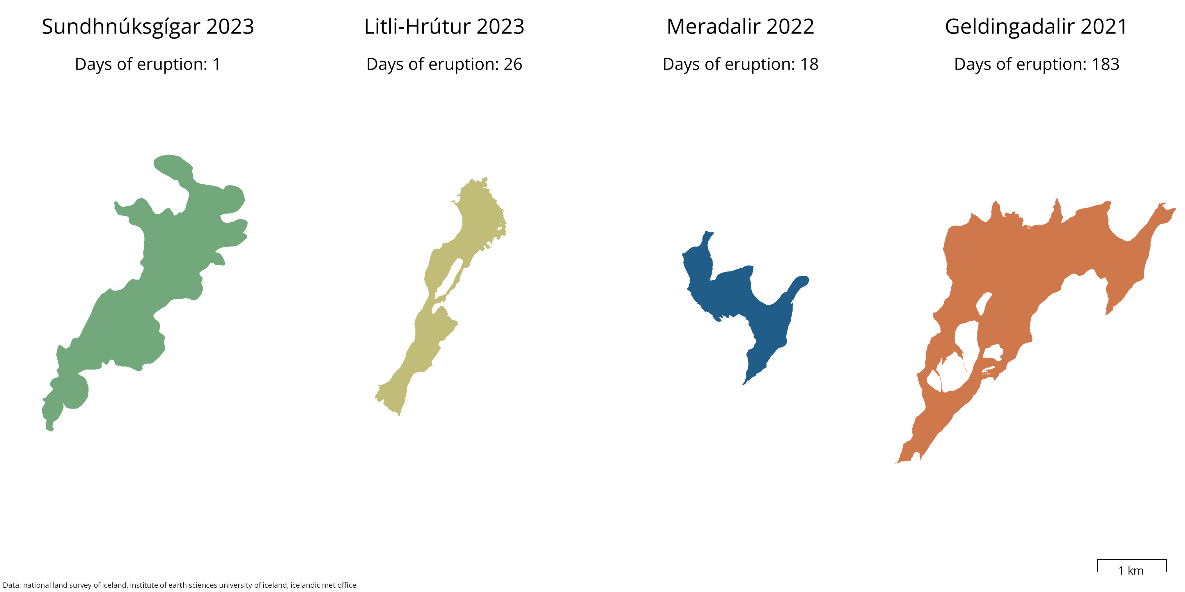
Although the eruption activity has diminished quite fast, it's not over yet. Also, the start of this eruption was absolutely massive. Let us compare lava area with the previous eruptions at #Fagradalsfjall and number of eruptive days with this one.
Snow scientist (mountains, arctic) often behind a screen, sometimes in the fresh air.
Satellite, photogrammetry, mountain hydrology.
At the Pyrenean Institute of Ecology in Zaragoza, Spain.
boosted:
Depuis quelques temps je passe par https://elk.zone pour utiliser Mastodon. C'est sans conteste l'interface la plus belle et la plus ergonomique que j'ai rencontré jusqu'ici, je vous conseille de tester si ce n'est pas déjà fait! Merci et bravo @elk :)
boosted:
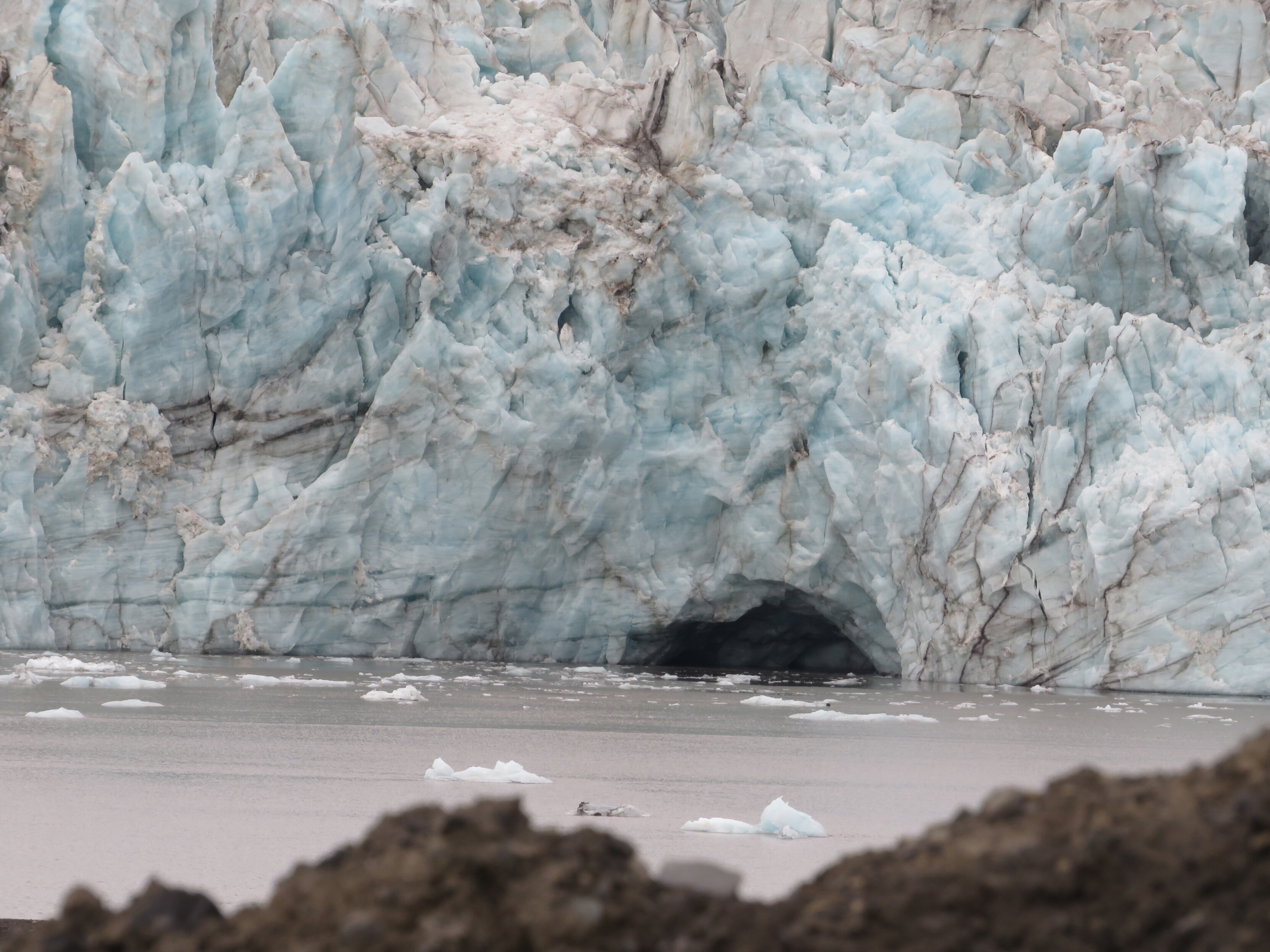
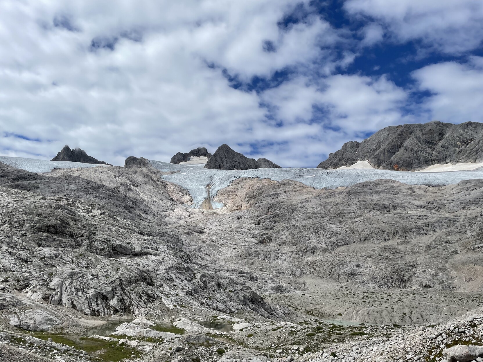
First week back after fieldwork; I miss seeing beautiful glaciers everyday but now it's time to catch up on the huge pile of work tasks...
boosted:
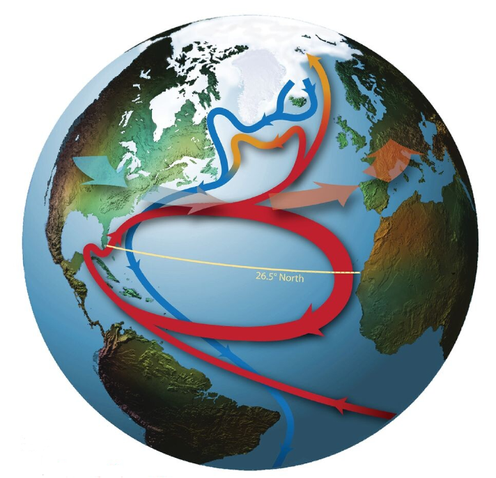
Will the #AMOC collapse by 2025?
Here's what we know from direct observations (since 2004). A thread.
Image from Srokosz & Bryden (2015) https://shorturl.at/ryB34
1/11
Back to Spain after 2 months at University of Iceland (Reykjavik).
Trying to measure snow depth with ICESat-2 and the ArcticDEM over cloudy Iceland.
The air temperature here is the water temperature of the warm pools there. Acclimatizing is needed :)
How to measure snow depth with ICESat-2 ?!
Combine ICESat-2 ATL06 snow-on elevation with snow-off elevation from airborne lidar or satellite photogrammetry #Pléiades @cnes !
https://tc.copernicus.org/articles/17/2779/2023/
boosted:
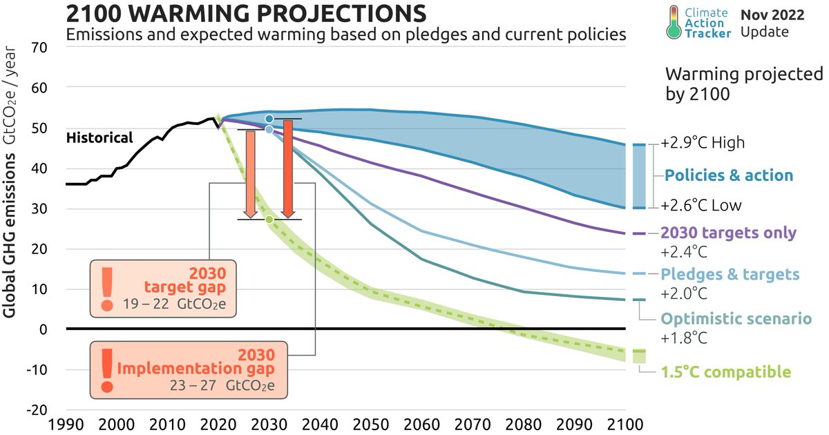
Everyone got the memo that we're supposed to reduce our emissions by half in 7 years, right?
boosted:
I went to the European Geosciences Union General Assembly in Wien (hum...about 3 weeks ago) #EGU23 @EuroGeosciences
I presented a way to measure snow depth with #ICESat2 @nasa (https://zenodo.org/record/7892450#.ZF5NYKXP02w) and projections of the snowpack evolution in spanish mountains (https://zenodo.org/record/7892437#.ZF5NYaXP02w)
I went there by train (Grenoble-Geneva-Zürich-Wien, Wien-Zürich-Paris-Barcelona). Night train between Wien and Zürich always got delayed ~2h, keep that in mind before planning your trip!
boosted:
Comparer le RGE Alti de l'IGN avec les photos aériennes de Google:
https://sgascoin.users.earthengine.app/view/hillshade-ign-rge-alti-1m
Ce n'est pas encore le Lidar-HD mais on y trouve déjà des perles de structures paysagères cachées. Appli réalisée par Simon Gascoin, hydrologue au CNRS - merci!
#lidar
boosted:
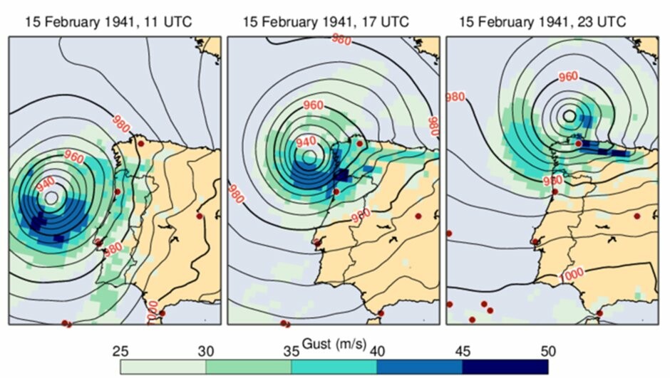
Hourly reanalysis data from ERA5, the fifth-generation global climate and weather reanalysis, is now available from 1940 to the present day!
This extends the ERA5 data record to over 83 years & is the backbone of many C3S products & services.
Figure below shows a 1941 storm over NW Spain - now resolved by ERA5
#reanalysis #CopernicusClimate #Climate #ClimateCrisis #ECMWF #EarthObservation #ERA5 #OpenScience #OpenData
boosted:
#OSM
Suite au tremblement de terre en #Turquie, il y a des projets à cartographier de manière urgente sur HOT !
On s'y retrouve pour montrer à nouveau la force de :osm: ?
boosted:
Are you #botanist or field #ecologist and interested to do your graduation thesis (#bachelor or #master) or an #internship in great scenery, on a hot topic and in cool climate (so far)? We look for field assistance in the #Dachstein #glacier forefields to study plant #traits and #succession this summer. More information here:
https://recruitingapp-5128.de.umantis.com/Vacancies/2674/Description/2
Please boost!
boosted:
RT @lalifou@twitter.com
Effet #houawouw avec le nouveau #alps #snow #monitor du @cesbiolab@twitter.com @ObsMip@twitter.com : https://labo.obs-mip.fr/multitemp/apps/alps-snow-monitor/ Qui faut-il remercier? @sgascoin@twitter.com @smlmrn@twitter.com et al. Auprès de qui le faire connaître? @Meteovilles@twitter.com @bonpote@twitter.com #allmyfriends
boosted:
** Internship offer **
Funded. Based in marvelous Iceland. Try to map snow depth with open source satellite datasets (ArcticDEM, Sentinel-2)
https://lufi.ethibox.fr/r/hbovoTPtdt#+nkJ8GBdfwYYOxpDlIK2g7oZ93IVOcNG8kd+0qlojOw=
@davidho @helenczerski I struggle a bit to understand how it is going in the Pacific Ocean... Nice otherwise!
boosted:
Put a raindrop anywhere and see where it ends up.
** Internship offer **
Funded. Based in marvelous Iceland. Try to map snow depth with open source satellite datasets (ArcticDEM, Sentinel-2)
https://lufi.ethibox.fr/r/hbovoTPtdt#+nkJ8GBdfwYYOxpDlIK2g7oZ93IVOcNG8kd+0qlojOw=
@jsolly I never used GEDI data! But ICESat-2, yes, to map snow depth https://tc.copernicus.org/preprints/tc-2022-191/
What do you measure with GEDI? :)
Aside from the scientific part, I am thrilled by Lindy Hop, train, fruit trees and Fiat Panda 1990's style 😀
Client Info
Server: https://mastodon.social
Version: 2025.04
Repository: https://github.com/cyevgeniy/lmst