Quantitative Validation Of Icesat-2 ATL24 In Shallow Marine Environments Using Reference-Grade Bathymetric Data
--
https://doi.org/10.1080/01490419.2025.2608329 <-- shared paper
--
https://doi.org/10.1029/2023EA003270 <-- shared paper
--
#GIS #spatial #mapping #satellite #remotesensing #earthobservation #ICESat2 #ATL24 #photonreturn #bathymetry #multibeam #echosounder #shallowwater #seafloor # mapping #validation #depth #elevation #coast #coastal #LiDAR #MudjimbaIsland #Australia #Whangaroa #harbour #NewZea;and #corrleation #BallyteigeBay #Ireland #bathymetric #profile #QAQC #MBES #sonar #acoustic #fedscience #opendata #publicgood #publicservice #engineering #water #hydrology #marine #ocean #hydrospatial
@nasa
#ICESat2
Moon Phase and Libration, 2026 🌑
#Albedo #Animation #Elevationdata #ICESat2 #LOLA #LRO #LROC #LandIce
⏩ 3 new pictures and 3 new videos from NASA (SVS) https://commons.wikimedia.org/wiki/Special:ListFiles?limit=35&user=OptimusPrimeBot&ilshowall=1&offset=20251213125646
Spinning Earth with clouds, atmosphere, and night lights 🌎🛰️
#Clouds #Earth #ICESat2 #ISS #Nightlights #Orbit #OrbitCoverage #Satellite
⏩ 2 new pictures and 2 new videos from NASA (SVS) https://commons.wikimedia.org/wiki/Special:ListFiles?limit=8&user=OptimusPrimeBot&ilshowall=1&offset=20250722125721
"ETOPO 2022 is an updated topographic–bathymetric dataset at 15 arcsec global resolution that incorporates bare-Earth datasets with forests and buildings removed. ETOPO 2022 integrates more than a dozen source datasets for land topography, sea bathymetry, lake bathymetry, and ice-sheet bed elevation data, all of which have been carefully evaluated for quality, accuracy, and seamless integration."
Quality controlled with nearly a trillion #ICESat2 #LIDAR shots.
Did some successful microwave keyhole shots back in the day, using #SRTM data. This would have been even better.
ESA And NASA Deliver First Joint Picture Of Greenland Ice Sheet Melting
--
https://www.esa.int/Applications/Observing_the_Earth/FutureEO/CryoSat/ESA_and_NASA_deliver_first_joint_picture_of_Greenland_Ice_Sheet_melting <-- shared technical article
--
https://doi.org/10.1029/2024GL110822 <-- shared paper
--
[Visualising the latest results from ESA's CryoSat radar altimeter, consistent with measurements from NASA's ICESat-2 laser altimeter]
--
#GIS #spatial #mapping #remotesensing #earthobservation #cryosphere #Greenland #icesheet #melting #CryoSat #satellite #ICESat2 #spatiotemporal #spatialanalysis #Jakobshavn #glacier #ice #snow #radar #laser #iceloss #climatechange #altimeter #elevation #topography #height
@ESA @nasa
#ESA and #NASA satellites deliver first joint picture of #Greenland Ice Sheet melting
#GlobalWarming is causing the Ice Sheet to melt and flow more rapidly, raising sea levels and disturbing weather patterns across our planet. Precise measurements of its changing shape are of critical importance.
Scientists have now delivered the first measurements of Greenland Ice Sheet thickness change using #CryoSat2 and #ICESat2
https://phys.org/news/2024-12-esa-nasa-satellites-joint-picture.html
I'm happy to announce a new version of our global coastal DTM: DeltaDTM v1.1. 🎉 Now up to 30 m (was 10 m) above the EGM2008 geoid, with improved accuracy across the board. Specifically we now use CopernicusDEM 2023_3 (was 2022_2) as the input and add another year of @NASA #ICESat2 data. The method stayed the same and is described in https://doi.org/10.1038/s41597-024-03091-9. Get it at https://doi.org/10.4121/21997565, or as an GEE asset `users/maartenpronk/deltadtm/v1-1`. #elevation #terrain
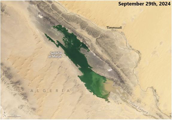
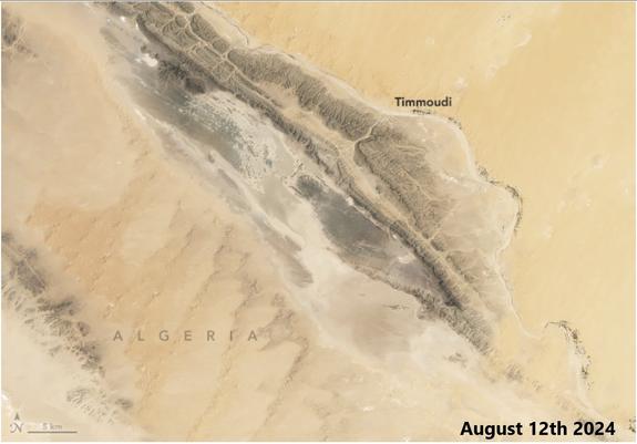
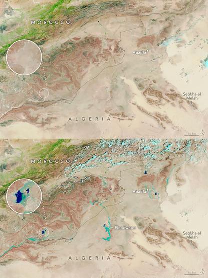
Water For A Desert Lake In Algeria [NASA Earth Observatory, September 29th 2024]
--
https://earthobservatory.nasa.gov/images/153475/water-for-a-desert-lake-in-algeria <-- shared technical link
--
https://www.space.com/sahara-lakes-appear-after-rain-soaks-desert-before-after-images <-- shared technical article
--
#GIS #spatial #mapping #extratropical #cyclones #remotesensing #imagery #satellite #extremeweather #SebkhaelMelah #algeria #climatechange #water #hydrology #lake #flood #flooding #sahara #desert #landsat #landsat9 #OLI2 #wadi #arid #icesat2 #SaharaDesert #IMERG #ERA5 #weather #spatialanalysis # meteorology #orographiclift
#NASA #USGS
Rules Of River Avulsion Change Downstream
--
https://doi.org/10.1038/s41586-024-07964-2 <-- shared paper
--
#GIS #spatial #mapping #river #water #hydrology #avulsion #geomorphology #geomorphometry #floodplain #flood #flooding #course #risk #hazard #elevation #topography #hydromorphic #hydrospatial #model #modeling #factors #coast #coastal #mountain #fan #riskassessment #global #spatialanalysis #management #mitigation #prediction #remotesensing #ICESat2 #FABDEM #Copernicus #algorithm #fluvial #alluvial #sediment #alluvium #sediment #machinelearning #graphdata #geostatistics #spatiotemporal
#NASA:
"
Arctic Sea Ice Near Historic Low; Antarctic Ice Continues Decline
"
https://www.nasa.gov/earth/arctic-sea-ice-near-historic-low-antarctic-ice-continues-decline/
24.9.2024
#Antarctic #Arctic #ArcticOcean #ClimateChange #DMSP #EO #ice #ICESat #ICESat2 #Klimawandel #NASA #Nimbus7 #NOAA #NSIDC #Raumfahrt #Satelliten #SpaceFlight
Tundra Vegetation To Grow Taller, Greener Through 2100, Nasa Study Finds
--
https://landsat.gsfc.nasa.gov/article/tundra-vegetation-to-grow-taller-greener-through-2100-nasa-study-finds/ <-- shared technical article
--
https://doi.org/10.1038/s43247-024-01454-z <-- shared paper
--
#GIS #spatial #mapping #model #modeling #climatechange #Alaska #Yukon Alaska #Canada #Scandinavia #Russia #boreal #borealforests #forests #vegetation #tundra #permafrost #remotesensing #satellite #ICESat2 #landsat #spatialanalysis #spatiotemporal #forecast #biome #landscape #canopy #transitional #canopycover #ABoVE #forest #hydrobasins #water #hydrology #taiga #canopyheight #cimp6 #SSP #bioclimate
@nasa
Evaluating The Uncertainties In Forest Canopy Height Measurements Using ICESat-2 Data
--
https://doi.org/10.34133/remotesensing.0160 <-- shared paper
--
https://svs.gsfc.nasa.gov/4936 <-- shared technical article, NASA – “Studying vegetation canopy with ICESAT-2”
--
#GIS #spatial #mapping #remotesensing #earthobservation #ICESat #ICESat2 #forest #ecosystems #canopy #naturalresources #LiDAR #ALS #satellite #metrics #evaluation #tree #trees #vegetation #physiography #forestcanopy #canopycover #spatialanalysis #model #modeling #regional #global #scale
NASAがICESat2で氷を観測しました #NASA #ICESat2
https://x.com/NASA/status/1727381670410805300
Phytoplankton May Be Abundant Under Antarctic Sea Ice, Study Suggests [remote sensing]
--
https://www.nasa.gov/feature/esnt/2022/phytoplankton-may-be-abundant-under-antarctic-sea-ice-study-suggests <-- shared article
--
https://doi.org/10.3389/fmars.2022.942799 <-- shared paper
--
#GIS #spatial #mapping #antarctic #remotesensing #gischat #satellite #nasa #icesat2 #earthobservation #oceanic #foodchain #phytoplankton #food #foodsource #marine #bloom #blooms #model #modeling #ice #icemass #sunlight #floats #datacollection #scubadiving #diving #elevation #DEM #water #cloud #cloudformation #climatechange #climate #energy #seaice
#NASA
I went to the European Geosciences Union General Assembly in Wien (hum...about 3 weeks ago) #EGU23 @EuroGeosciences
I presented a way to measure snow depth with #ICESat2 @nasa (https://zenodo.org/record/7892450#.ZF5NYKXP02w) and projections of the snowpack evolution in spanish mountains (https://zenodo.org/record/7892437#.ZF5NYaXP02w)
I went there by train (Grenoble-Geneva-Zürich-Wien, Wien-Zürich-Paris-Barcelona). Night train between Wien and Zürich always got delayed ~2h, keep that in mind before planning your trip!
Startup's Proposed Satellite Swarm Would Create 3D Maps Of Earth's Entire Surface
--
https://gizmodo.com/planned-satellite-swarm-create-3d-maps-earth-surface-1850405693 <-- shared article
--
#GIS #spatial #mapping #topography #elevation #remotesensing #LiDAR #startup #NUVIEW #satellite #global #swarth #NASA #ICESat2 #spatialanalysis #3D #survey #groundsurface
#ICESat2 fires 10,000 laser pulses a second, sending six green beams of light toward Earth.
Scientists can measure the height of ice, oceans, trees and more based on how long it takes those beams to bounce off Earth and return to the satellite. http://go.nasa.gov/6851
[Video embedded in original tweet]
#NASAEarth
RT @i_ameztoy: #EarthObservation fleet in January 2023 🛰️🌎🌍🌏
#Landsat9 #Landsat8 #Terra #NOAA20 #SWOT #ICESat2 #Aqua #Sentinel6 #SMAP #GOES #SNPP #OCO2 & many more via @NASA's Scientific Visualization Studio
🐦🔗: https://n.respublicae.eu/CopernicusEU/status/1639624349383532544


