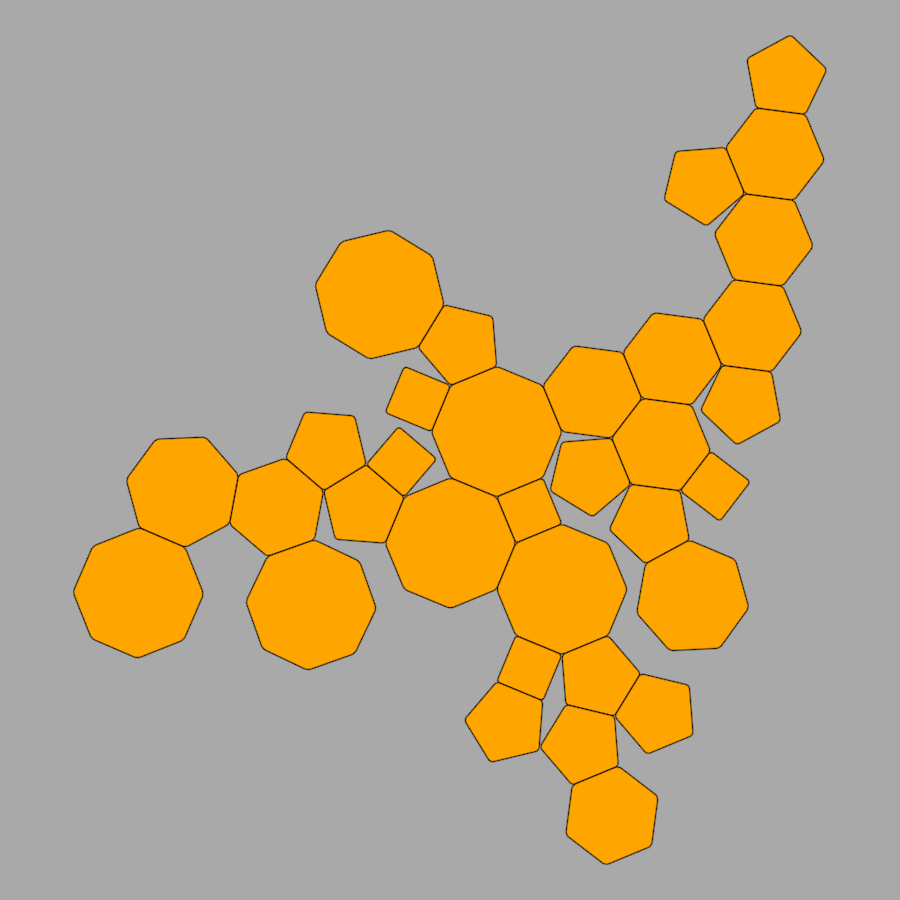
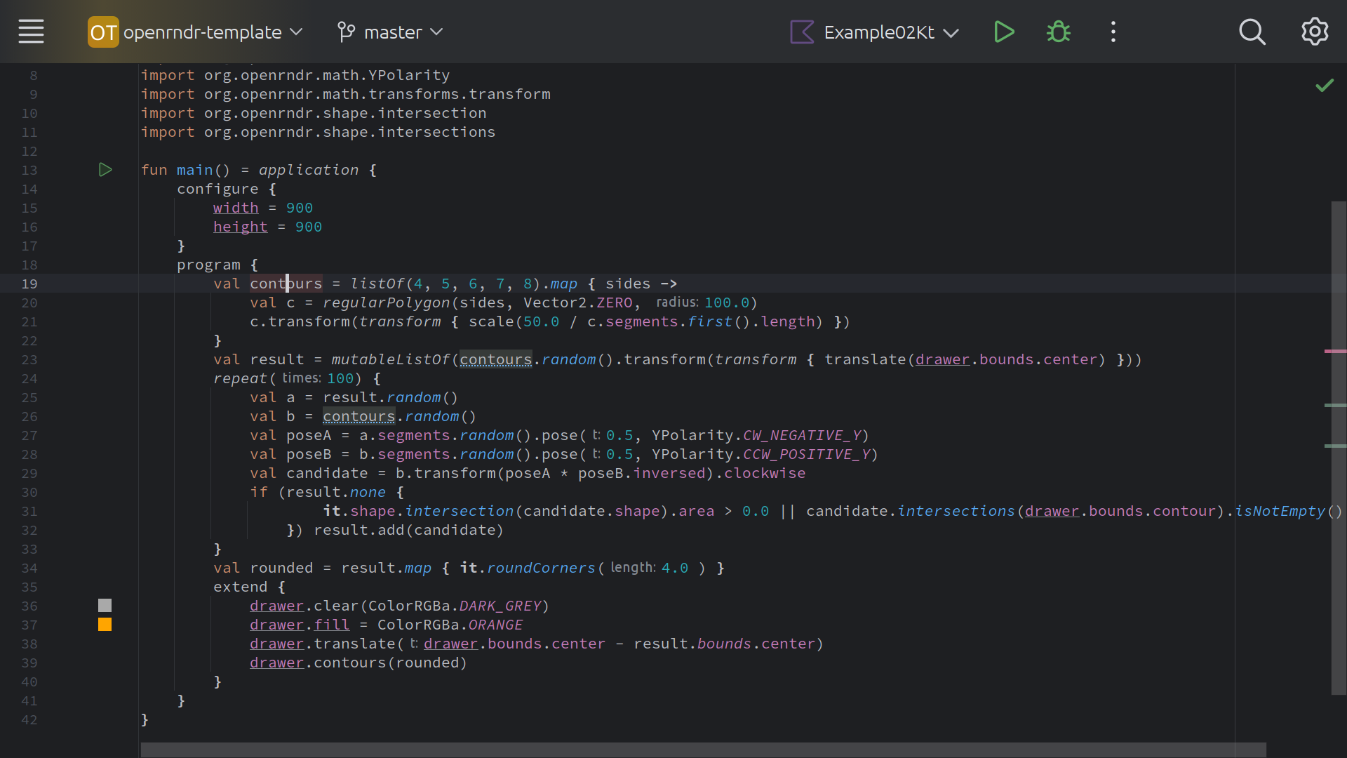
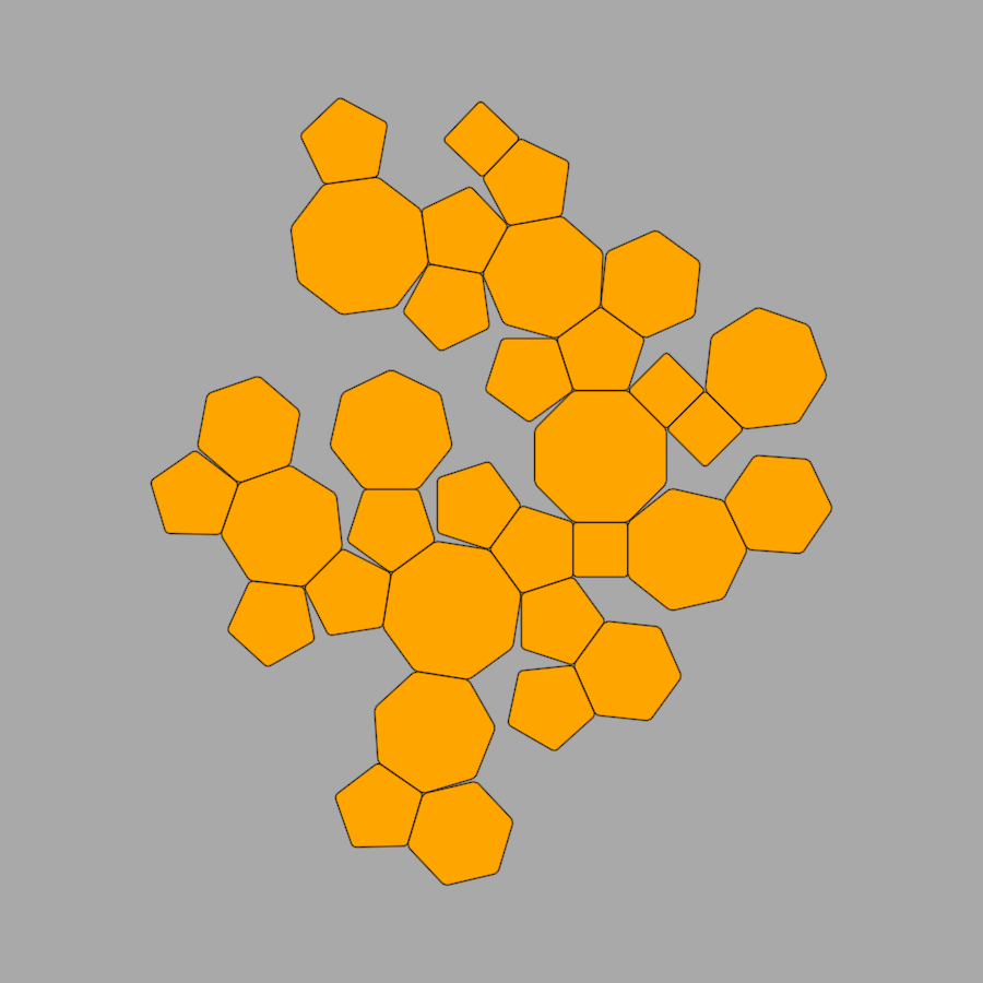
#polygons

Added a simple rule so shapes have children of the same type. A bit more orderly.
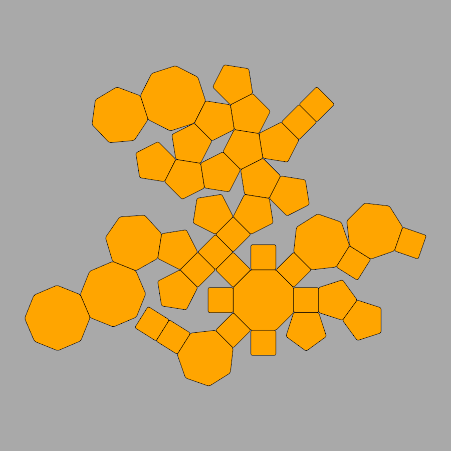
I'm writing small programs for a presentation. Programs that are simple to write in one framework or language which would be not so simple to write in different ones.
I feel like printing, cutting and folding it to create a 3D shape, knowing that it would not produce a nice closed one 🙂
#CreativeCoding #OPENRNDR #Kotlin #Geometry #RegularPolygons #Polygons


30 DAY MAP CHALLENGE 2024 | DAY 3 - POLYGONS
Shapes of (K)yøu(si)
of triangles, circles, and ovals
DATA
> Digitized from OpenStreetMap (copyright OSM contributors)
PROCESS
> Duplicate the digitized layer.
> Apply a hand-drawn smudgy-pen outline style and a pencil fill with categorized symbology.
> Styles are from the hand-drawn styles by Andy Woodruff (https://www.facebook.com/bnhr.xyz/posts/pfbid02BKbYMnv5quZcDjNoYiGnZPzc2MqWwU8YbuypFJMdYA242WibaNnsZLsYErvWQEfdl)
#30DayMapChallenge #30DayMapChallenge2024 #Day3 #Polygons #MadeWithQGIS #QGIS #QC #Kyusi #QuezonCity #Philippines

#30DayMapChallenge Day 3: Polygons
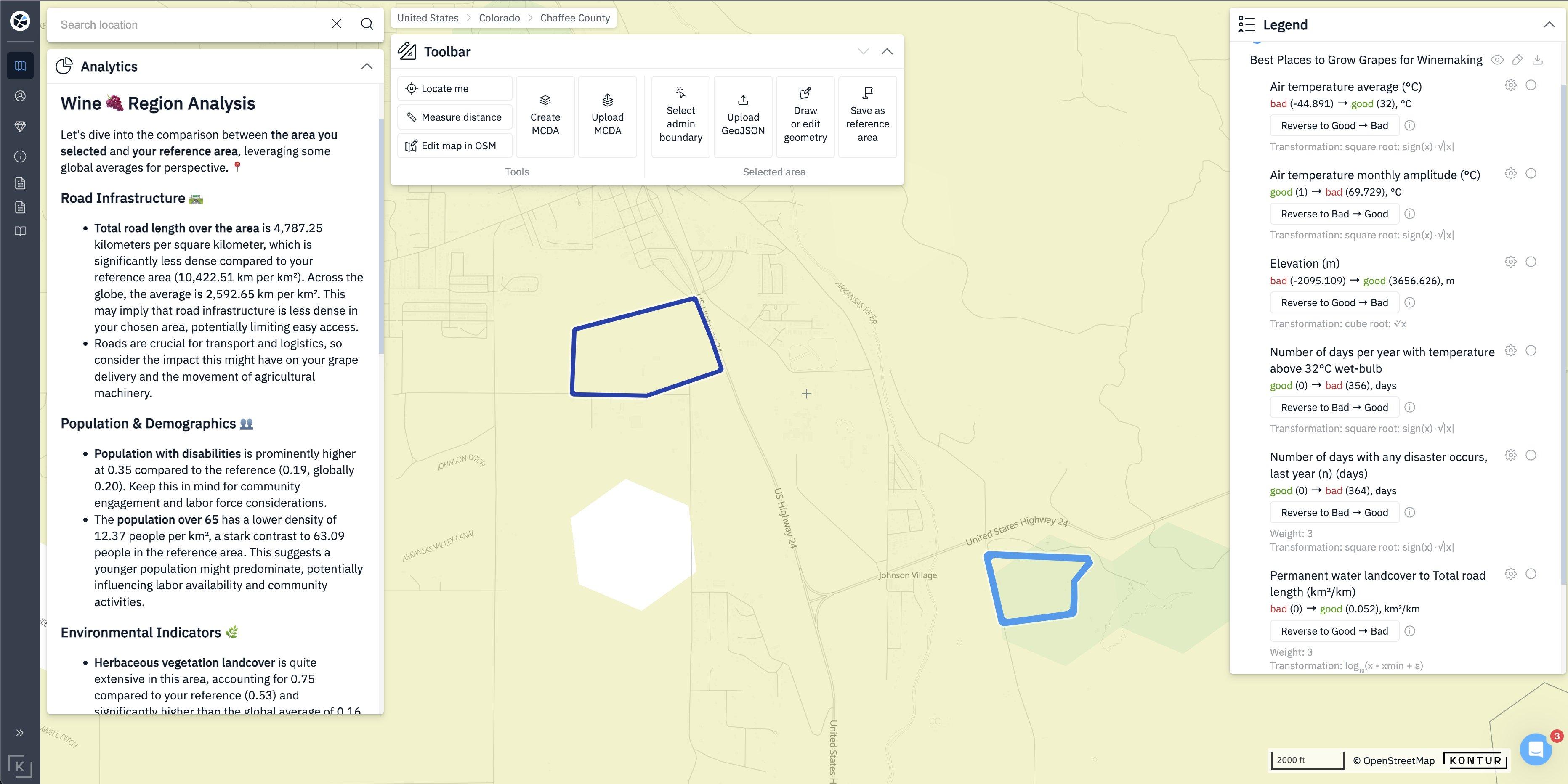
For a vineyard owner 🍇, choosing the best spot is the key to quality wine! With Kontur Atlas, we compared two areas to find the perfect one 🗺️
Curious? Let’s connect!
#30DaysMapChallenge #VineyardPlanning #SustainableAgriculture #KonturAtlas #Polygons
#30DayMapChallenge #polygons #Spain #DANA #humanmobility #movilidad up to 2% of typical daily mobility in Spain was affected by DANA as of 31 October, based on open mobility data for 2023 and road closures data. Via: #rstats #spanishoddata https://ropenspain.github.io/spanishoddata/
Day 3 of #30DayMapChallenge #polygons, which I used as a prompt to explore some of the free data available in Denmark, as well as the standard #QGIS plugins provided by #klimadatastyrelsen.
A map of eel grass habitat in #Copenhagen harbour in 2012. If you have access to more recent data, I'd love to have it!
Explanation: https://sternaparadisaea.net/30-day-map-challenge/
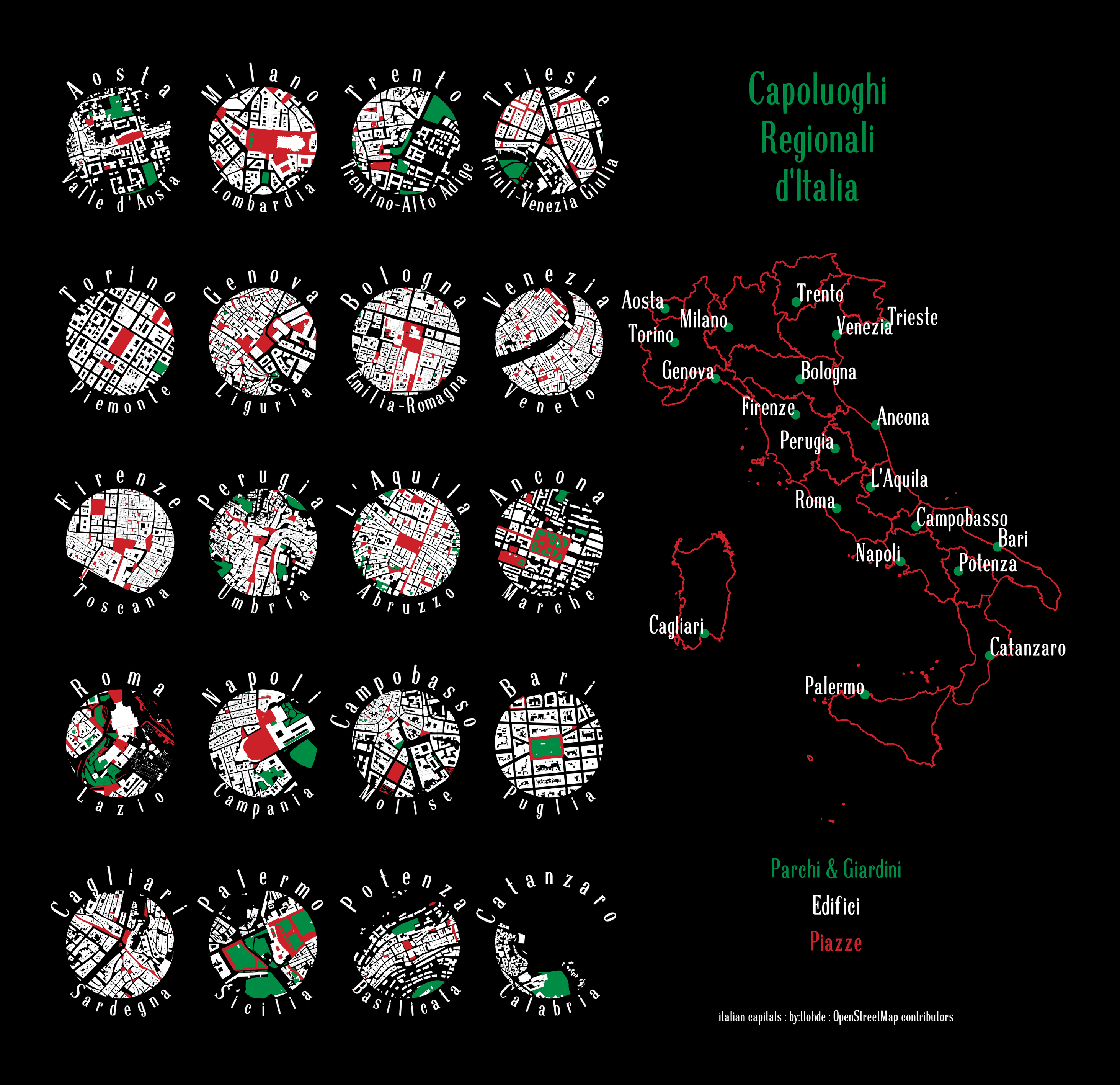
Regional Capitals of Italy.
Polygons of Parks and gardens (green), buildings (white) and piazzas/squares (red). Data from #OpenStreetMap via #osmnx and plotted with #geopandas & #matplotlib. font: Scoglietto by Petra Heidorn
took me far too long to work out the required OpenStreetMap tags to get the nodes for the regional capitals.
#30DayMapChallenge Day 3: #Polygons
https://youtu.be/oRZ2aE2VuEA?si=jm8UDJLS8GMeYN0c
#פריי #1995is #DOSGaming #שנות_ה90 #Prey of the #90s #Apogee_Software #3DRealms #RetroGaming #Retro #GamersUnite #3D #polygons #MSDOS #Microsoft #מיקרוסופט #נוסטלגיה #רטרו #תלתמימד #תלתממד #מגניב #ישן #PackardBell #ווינטג' #vintage_computing #cool #הימיםהטובים #90s_computers
Like #Pixar #RetroVibes #90sEdgeTechnolegy #90sTech #90sPC #BeBrave #GoodDays #NaveicDays #PureDays #90sheaven #whitePCs #olddays #90slove #millennium #lowpoly #oldtech #oldternet #SilconGraphics like
More emergency alert GIS fun here, where apparently the polygon for St. Croix, Virgin Islands is a wee bit... inaccurate (that said, it PROBABLY works fine for WEA/wireless alerts as it is unlikely there are cell towers on the beach areas not covered by the alert.... maybe) #gis #polygons https://m.ai6yr.org/@easwatch/113115873371880656
More https://thi.ng/geom tessellation updates/features, now also supporting point/vertex welding, avoiding the creation of duplicate vertices when recursively tessellating a shape. Also, using https://thi.ng/adjacency we can then easily convert a tessellation into a graph (directed or undirected) and extract unique edges from it, all with absolutely minimal userland code...
This feature is super useful for plotting tessellations like these, but the extracted graph can also be used for a large number of other purposes (incl. nav meshes / path finding for agents). The adjacency package contains a bunch of helpful graph algorithms...
New example (#168):
https://demo.thi.ng/umbrella/geom-unique-edges/
Source code:
https://github.com/thi-ng/umbrella/blob/develop/examples/geom-unique-edges/src/index.ts
#ThingUmbrella #Geometry #Tessellation #Mesh #QuadMesh #Graph #Polygons #TypeScript
Just updated the convex hull example (and the underlying `clipConvex()` function in https://thi.ng/geom) to support paths (shown in the examples) and complex polygons...
Demo:
https://demo.thi.ng/umbrella/geom-convex-hull/
Source:
https://github.com/thi-ng/umbrella/blob/develop/examples/geom-convex-hull/src/index.ts
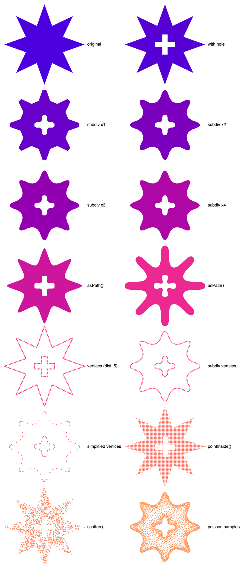
Still only on a feature branch, but over the past few days I've been working on updating https://thi.ng/geom to add support for polygons with holes and paths with holes (or more generally support for sub-paths, e.g. multiple curves). Since both of these shape types are containers of multiple geometries and therefore require in some situations (e.g. shape conversions) different handling than the other shapes with a single boundary/geometry, adding support for these also includes updating a dozen or so polymorphic shape operators/functions and unfortunately will involve a few of breaking changes. For instance, some of these functions are returning an array of shapes now, instead of just a single one. Also related, some of the other geom support packages (e.g. https://thi.ng/geom-axidraw, https://thi.ng/geom-sdf) will have to be refactored more and partially have been already (likely only internally, though)...
As part of this work, I've also just added example #160(!!!) to demonstrate & test out some of this new functionality:
Demo:
https://demo.thi.ng/umbrella/geom-complex-poly/
Commits:
https://github.com/thi-ng/umbrella/compare/feature/geom-complex-paths
I will of course send another update once this all has been merged & released...
#ThingUmbrella #Geometry #Polygons #Shapes #PoissonDisk #TypeScript #JavaScript #OpenSource
Client Info
Server: https://mastodon.social
Version: 2025.04
Repository: https://github.com/cyevgeniy/lmst