
議員: 用無人機搵路邊雜草 指路邊雜草叢生影響市容 無人機科技巡視雜草黑點
民建聯立法會議員周浩鼎 2月 4日於立法會會議就街道雜草問題提出書面質詢,運輸及物流局局長陳美寶作書面回覆。周 […]
#航拍 #AI #GeoAI #RDDS
https://unwire.hk/2026/02/04/chow-ho-ding-weeds-ai-rdds-hongkong/life-tech/drone/?utm_source=rss&utm_medium=rss&utm_campaign=chow-ho-ding-weeds-ai-rdds-hongkong
#GeoAI


Deep Learning in QGIS with the Deepness Plugin
Review of the QGIS GeoAI plugin
#Geospatial #AI for #Health: A New Era of Insight, #Intelligence, and Impact https://tinyurl.com/5n8znud3
#healthGIS #publichealth #spatial #analysis #geoAI #GIS #esri #arcgis #mapping @esri @esri_health @esrifederalgovt @esrislgov @esritraining @urisa


Finally found some time to look into the QGISMCP plugin.
The original connects #QGIS :qgis: to #Claude through the Model Context Protocol #MCP. I rewired it to work with a local European alternative: the new ministral model by #MistralAI running in #Ollama 🎄👩💻:cupofcoffee:

🎥 Just released a new video exploring the #QGIS #GeoAI plugin, a powerful way to bring #AI into everyday mapping workflows. Watch here: youtu.be/PMEZaW71YSA
Thanks to @giswqs.bsky.social@bsky.brid.gy for his brilliant work and clear documentation!
Review of the QGIS GeoAI plugi...
10 Tips & Tricks: Making Training #Data for #GeoAI in #ArcGIS https://tinyurl.com/3bkdsx72
#AI #bestpractices #GIS #esri #mapping #GISchat #geospatial @esri @esrifederalgovt @esrislgov @esritraining


🌍 Recently I gave a brief intro talk on three connected deep learning concepts: GNNs, embeddings, and foundation models.
URL: https://jakubnowosad.com/agforum2025
The slides include reproducible R examples showing how each concept works in practice.


Proceedings of the 2025 JRG: Last week, the fourth Journée Romande de la Géoinformation (#JRG) took place in Ecublens with more than 800 participants. Now, all videos and presentations of the plenary sessions are available online. #GeoAI #DSS #DigitalTwin
https://spatialists.ch/posts/2025/11/21-proceedings-of-the-2025-jrg/ #GIS #GISchat #geospatial #SwissGIS

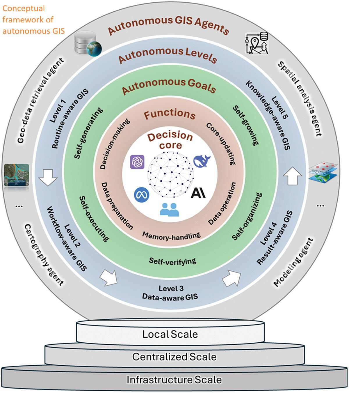
GIScience In The Era Of Artificial Intelligence - A Research Agenda Towards Autonomous GIS [GeoAI]
--
https://www.psu.edu/news/earth-and-mineral-sciences/story/mapping-new-frontier-ai-integrated-geographic-information-systems <-- shared technical article
--
https://doi.org/10.1080/19475683.2025.2552161 <-- shared paper
--
https://youtu.be/JPwIGH9uPm0?si=D9MLgolEyizcWKT9 <-- shared video, “This is a video demo for the GIS…”
--
#GIS #spatial #mapping #opensource #QGIS #GeoAI #AI #deeplearning #autonomousGIS #spatialanalysis #cartography #LLM #largelanguagemodels #geoprocessing #decisioncore #model #modeling #workflow #QAQC #autonomy #sociallyresponsible #publicgood
@Penn State University


We are pleased to announce that Alexander Zipf will deliver a keynote at the ISPRS/ISDE Conference 2025, where he will discuss how Geographic Information, particularly #OpenStreetMap, and #GeoAI can advance sustainable development.
📅 2-4 December 2025
📍 Nairobi, Kenya

Hello DSN Geospatial Community,
Geospatial insights do not only tell us where things happen — they explain why they happen and what we can do next. This is where GeoAI becomes transformative.
Join us for our Bi-monthly Webinar as we explore how spatial data and AI are powering more intelligent decision-making across healthcare, transportation, agriculture, retail, and public planning.
Date: Friday, 21 November 2025
Time: 4:00 PM
Venue: DSN General Community Telegram Group
Do not just interpret maps — learn how to convert location intelligence into strategy, optimization, and real impact.


The 1st International Conference on Geospatial Artificial Intelligence (GeoAI 2026), will take place in Ghent, Belgium, from June 3 to 5, 2026 #geoai
A Five-Year Milestone - Reflections On Advances And Limitations In GeoAI Research
--
https://www.acsu.buffalo.edu/~yhu42/papers/2024_AnnalsofGIS_GeoAI.pdf <-- shared 2024 paper
--
https://doi.org/10.1016/j.jag.2025.104368 <-- shared 2025 paper
--
[GeoAI has changed markedly since this 1st paper was written, but there is still much value in what it states]
#GIS #spatial #mapping #AI #spatialanalysis #GeoAI #theory #perspectives #Giscience #geography #advances #limitations #model #modeling #spatiallyexplicit #realworld #usecase #application #problemsolving #AAG #research #appliedscience #generalizability
@AAG


The Rise Of Geospatial Data-As-A-Service
--
https://geoaiunpacked.substack.com/p/geoai-unpacked-4-the-rise-of-geospatial <-- shared technical article
--
[this post should not be considered an endorsement of a particular service, etc]
“In this issue, [they] explored the rise of data-as-a-service (DaaS) in the geospatial sector. [They] look at how the industry has shifted from public data programs to a growing ecosystem of private data providers, the business models behind them, and the opportunities and challenges shaping this evolving market...”
#GIS #spatial #mapping #overview #learning #GeoAI #DaaS #dataasaservive


𝗛𝗲𝗶𝗚𝗜𝗧 𝗮𝘁 𝗦𝘁𝗮𝘁𝗲 𝗼𝗳 𝘁𝗵𝗲 𝗠𝗮𝗽 𝗘𝘂𝗿𝗼𝗽𝗲🌍📍
We will join @sotmeu with several sessions on #OpenStreetMap, #GeoAI, and humanitarian mapping.
Our talks cover topics such as the new ohsomeDB, transparency in AI-assisted mapping, the evolution of MapSwipe and MapTCHA, and humanitarian mapping with Missing Maps. We look forward to discussing how #OpenData, community collaboration and AI are shaping the future of mapping.
Our contributions: https://heigit.org/events/heigit-at-state-of-the-map-europe/

The Myth And Reality Of ‘Physics-Based’ Models In Geosciences
--
https://geoaiunpacked.substack.com/p/the-myth-and-reality-of-physics-based <-- shared technical article
--
“Across hydrology, fire, weather, and climate science, models are often described as physics-based—a phrase that evokes rigor, transparency, and trust. Yet, beneath the surface, much of what drives these models are empirical relationships and parameterizations rather than direct solutions of physical laws. These assumptions are necessary to make the equations computable, but they also introduce biases, tuning artifacts, and uncertainties that can propagate through every layer of simulation.
This doesn’t mean physics-based models are flawed or obsolete; rather, it highlights the complexity of modeling natural systems…”
#GeoAI #datadriven #physicsbased #model #modeling #usecase #appliedscience #accuracy #appropriateness #simulation #naturalsystems #hybrid #physicalrealism #hydrology #fire #weather #climate


What’s New in #AI Assistants in #ArcGIS (Oct 2025) https://tinyurl.com/3mp5hydz
#GeoAI #artificial_intelligence #GIS #esri #mapping #maps #GISchat #geospatial @esri @esrifederalgovt @esrislgov @esritraining @arcgispro @arcgisonline

1st International Conference on Geospatial Artificial Intelligence (#GeoAI2026) will take place in Ghent, Belgium on 3-5 June 2026.

Google amplia le funzioni AI in Google Earth, facilitando l’interazione con modelli che analizzano immagini satellitari, previsioni meteo e mappe di popolazione. Ora è possibile individuare infrastrutture a rischio o monitorare fenomeni come le fioriture di alghe 🌍🌧️. Accesso esteso a utenti professionali negli USA con piani avanzati.

Client Info
Server: https://mastodon.social
Version: 2025.07
Repository: https://github.com/cyevgeniy/lmst