
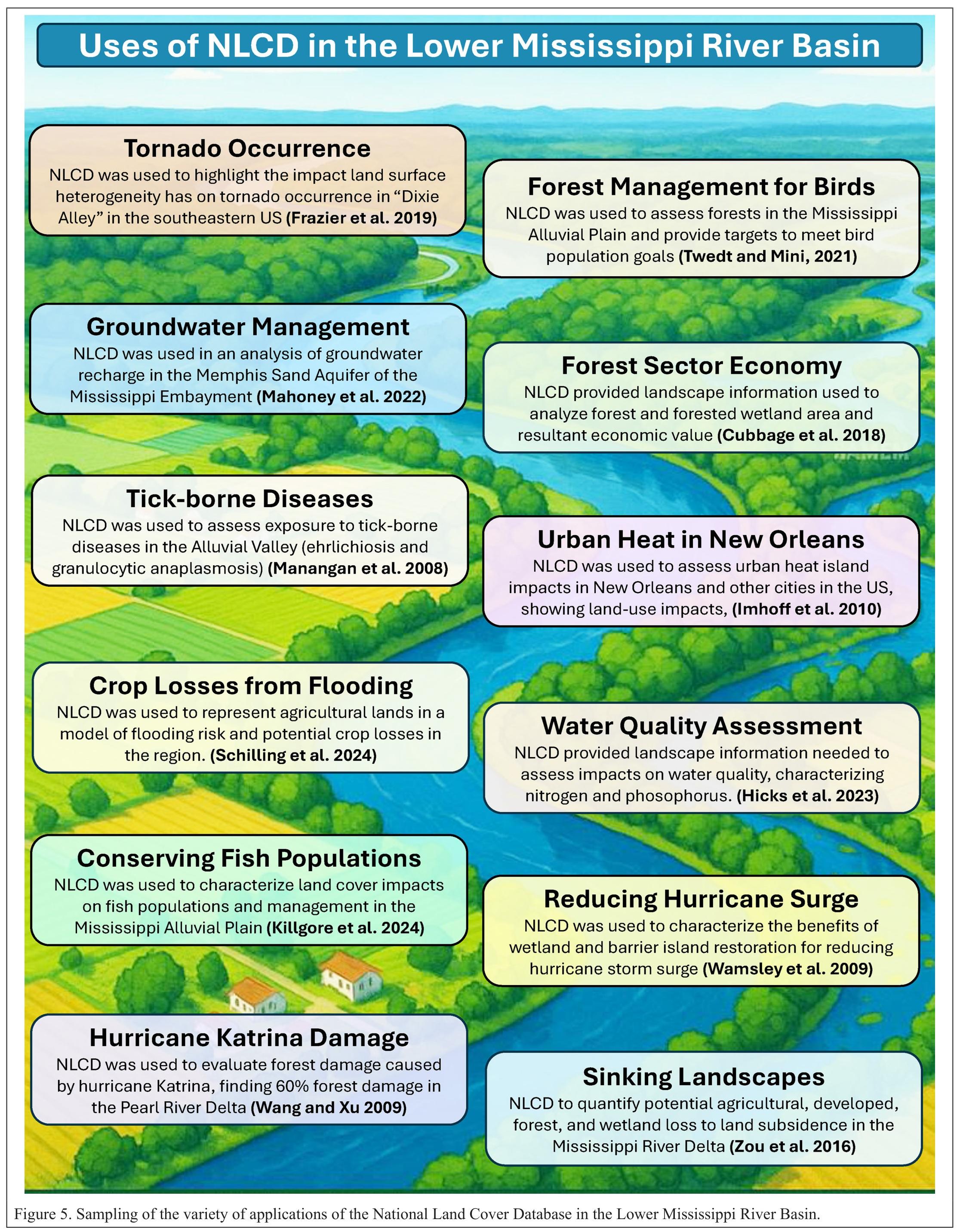
Thirty Years of the U.S. National Land Cover Database - Impacts and Future Direction
--
https://doi.org/10.14358/PERS.25-00121R2 <-- shared paper
--
“Editor's choice article for the October Issue of Photogrammetric Engineering and Remote Sensing.”
#GIS #spatial #mapping #remotesensing #opendata #earthobservation #landcover #USA #NLCD #MRLCC #history #datacollection #impervioussurface #classifaction #landform #forestcanopy #fedscience #fedservice #deeplearning #AI #spatialanalysis #change #monitoring #usecase #research #landmanagement #management #policy #planning #support #agriculture #urbanplanning #environment #ecosystems #biodiversity #conservation #water #hydrology #humanhealth #risk #hazard #soils #naturalhazard #spatiotemporal #landchange #forestry #watermanagement #waterquality #publicsafety #groundwater #NCLA #wildfire #stormwater #extremeweather
#USGS #EROS #NASA #USFS
#MRLCC


Thirty Years Of The U.S. National Land Cover Database [NLCD] - Impacts And Future Direction
--
https://doi.org/10.14358/PERS.25-00121R2 <-- shared paper
--
https://www.usgs.gov/centers/eros/science/annual-national-land-cover-database <-- shared #USGS Annual National Land Cover Database (open data)
--
https://www.usgs.gov/centers/eros/science/annual-national-land-cover-database <-- get the open NLCD data
--
#GIS #spatial #mapping #history #continuity #improvement #LandCover #Landuse #change #Landsat #NLCD #NationalLandCoverDatabase #earthobservation #remotesensing #landchange #monitoring #fedscience #publicgood #fedopendata #opendata #history #fedservice #MRLCC #USA #download #impervious #surface #forestcanopy #mosaics #accuracy #deeplearning #AI #research #landmanagement #agriculture #water #hydrology #cropland #biodiversity #conservation #urban #planning #publichealth #naturalhazard #assesment #risk #hazard #mitigation #national #nation #multiple #usecase
#USGS | #EROS


An Interagency Perspective On Improving Consistency And Transparency Of Land Use And Land Cover Mapping
--
https://doi.org/10.3133/cir1549 <-- shared USGS publication
--
#GIS #spatial #mapping #USA #nation #national #landcover #landuse #interagency #coast #coastal #change #remotesensing #satellite #risk #hazard #management #opendata #resources #vegetation #forest #agriculture #planning #climatechange #MRLCC #landchange #conservation #ecosystems #usecase #urbanplanning #water #watersecurity #foodsecurity #spatialanalysis #spatiotemporal #MultiResolutionLandCharacteristicsConsortium #federal #report
@USGS | @BLM | @USFS | @USFWS | @NOAA | @USDA

![Sankey diagram showing Multi-Resolution Land Characteristics (MRLC) member products (National Land Cover Database; Land Change Monitoring, Assessment,
and Projection; Landscape Fire and Resource Management Planning Tools; Landscape Change Monitoring System; Coastal Change Analysis Program; Cropland Data Layer;
and Rangeland Condition Monitoring Assessment and Projection) contributions to key products, services, and objectives in the 2023 Earth Observation Assessments (EOA)
agriculture and forestry societal benefit area (SBA). Green bars are products and yellow bars are societal benefits identified in the EOA 2023 agriculture and forestry SBA. Gray
lines show direct and indirect contributions of MRLC products to the agriculture and forestry SBA (from Rowe and Vanderhoof [2024]).](https://files.mastodon.social/cache/media_attachments/files/113/841/430/432/305/280/original/43fbf7c85a0626cc.jpg)

