It is IAH 'student night' next Tuesday in Sydney CBD, and there are #groundwater presentations from some of my #UNSW group. Open to all! Details are here:
https://www.linkedin.com/posts/iah-nsw-committee-816481125_hi-all-we-are-under-a-week-away-from-out-activity-7381149150538600449-N0z-
#groundwater
Why #windfarms attract so much #misinformation and #conspiracytheory
If you think #climatechange is a #hoax, you might believe #windturbines poison #groundwater.
Although we’ve known about #climate change from #carbondioxide as since at least 1950s, early arguments for #renewables tended to be seen more as a way of breaking stranglehold of #fossilfuel companies.
Meanwhile, advocates of renewables—especially wind—often found it difficult to build public support for wind.
https://arstechnica.com/science/2025/08/why-wind-farms-attract-so-much-misinformation-and-conspiracy-theory/
Pakistan’s solar-powered farming boom is depleting groundwater, turning a green revolution into a looming water crisis. ☀💧https://www.reuters.com/sustainability/boards-policy-regulation/solar-powered-farming-is-digging-pakistan-into-water-catastrophe-2025-10-02/
#pakistan #groundwater #irrigation #waterdeficit #agriculture
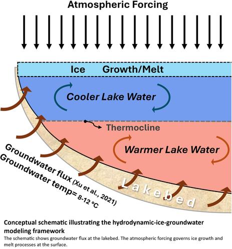
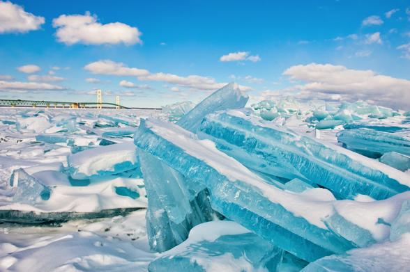
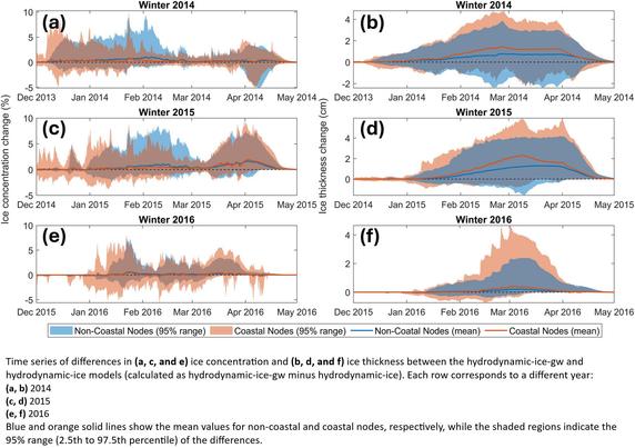
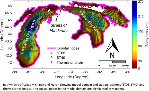
Intense Groundwater Flow Destabilizes Ice In North America's Great Lakes, Simulations Show
--
https://phys.org/news/2025-09-intense-groundwater-destabilizes-ice-north.html <-- shared technical article
--
https://doi.org/10.1029/2025WR040581 <-- shared paper
--
"KEY POINTS:
• Groundwater inflow enhances winter lake ice thickness by stabilizing the water column and reducing vertical mixing
• Ice responses to groundwater are strongest in coastal zones due to higher flux and shallow bathymetry
• Including groundwater in coupled models improves understanding of ice formation and winter lake processes…”
#water #hydrology #groundwater #flux #flow #GreatLakes #USA #LakeMichigan #LakeHuron #ice #climatechange #model #modeling #shoreline #coast #lakeice #melt #hydrodynamic #spatialanalysis #spatiotemporal #thermal #stratification #winter #bathymetry #coupledmodels #processes
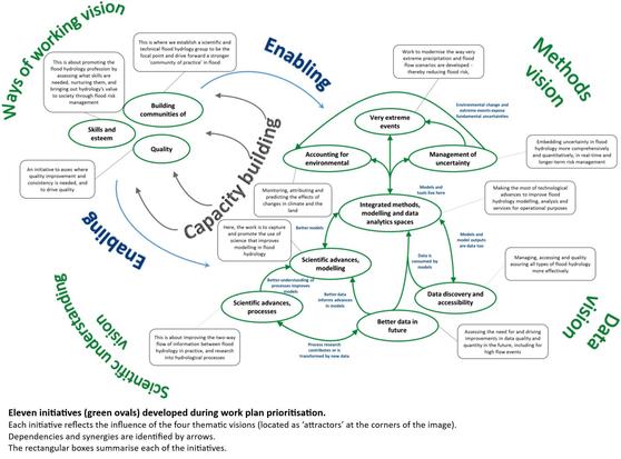
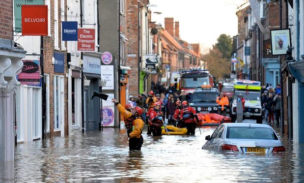
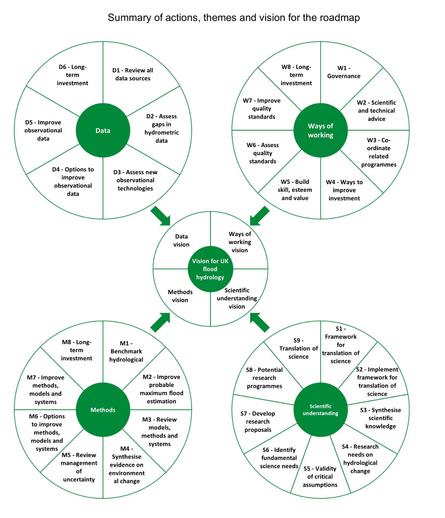
Flood Hydrology Roadmap [UK]
--
https://www.gov.uk/flood-and-coastal-erosion-risk-management-research-reports/flood-hydrology-roadmap <-- shared technical details
--
https://assets.publishing.service.gov.uk/media/62335ac2e90e070a54e18185/FRS18196_Flood_hydrology_roadmap_-_report.pdf <-- shared roadmap as a PDF
--
https://doi.org/10.2166/nh.2022.053 <-- shared paper
--
#water #hydrology #flood flooding risk hazard roadmap UK Britain cost #economics #publicsafety #publichealth #extremeweather #government #program #policy #mitigation #fluvial #floodhydrology #actionplan #England #Wales #Scotland #NorthernIreland #engineering #fluvial #pluvial #sewers #groundwater #reservoir #research #logistics #methods #operations #data #spatial #GIS #mapping #management #partnership #collaboration #regulations #interagency #riskmanagement #riskanalysis #practice #design #systems #landuse #change #climatechange
"Madison Boyle with the Amarillo Minority Coalition questioned the use of #groundwater for the data center, stating, 'Why are we using ground water that farmers could be using for agriculture, for AI data center, where it's going to deplete a resource that's not really renewable?'
"Boyle highlighted the strain on the #OgallalaAquifer, which is already depleting. Protest organizers urged city officials to consider future generations.
"Amarillo citizen Ashlyn Major called for transparency and suggested a public vote on the project. Fermi America has not responded to interview requests, but former Gov. #RickPerry, now vice president of #FermiAmerica, previously downplayed water concerns, emphasizing water recycling efforts."
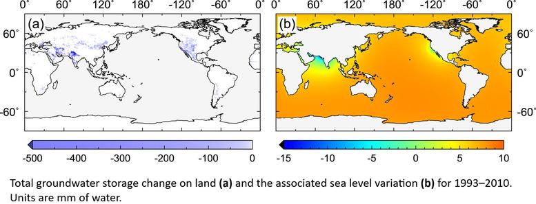
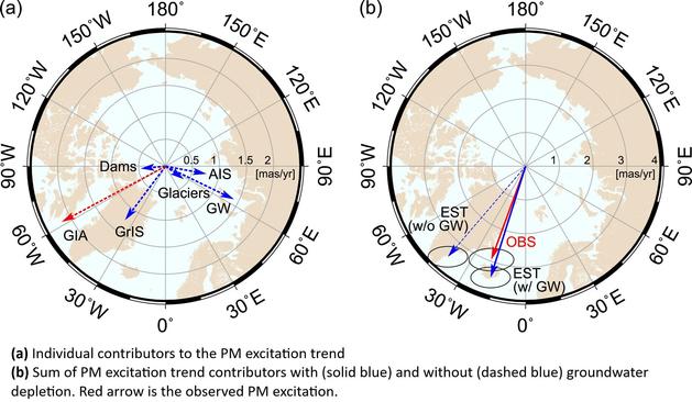
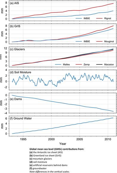
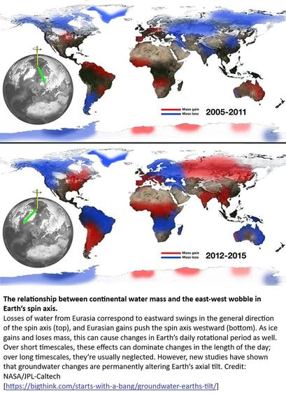
Earth Has Tilted 31.5 Inches. That Shouldn't Happen [groundwater pumping]
--
https://www.popularmechanics.com/science/environment/a65515974/why-earth-has-tilted-science/ <-- shared technical article
--
https://doi.org/10.1029/2023GL103509 <-- shared paper
--
“ • When humans pump groundwater, it has a substantial impact on the tilt of Earth’s rotation.
• Additionally, a study document [link above] just how much of an influence groundwater pumping has on climate change.
• Understanding this relatively recent data may provide a better understanding of how to help stave off sea-level rise…"
#hydrology #groundwater #depletion #pumping #extraction #sealevelrise #SLR #global #globe #earthtilt #humanimpacts #waterresources #anthropogenic #climatechange #model #modeling #monitoring #earth #rotation #water #redistribution #drift #pole #observation #spinaxis
Santa Fe water supply under threat from fracking waste.
https://www.reddit.com/r/SantaFe/comments/1nnmdan/santa_fe_new_mexican_governors_office_improperly/?utm_source=share&utm_medium=web3x&utm_name=web3xcss&utm_term=1&utm_content=share_button
#GovernorLujan-Grisham #NewMexico #Fracking #Water #GroundWater
In recent months, #EPA scientists have contributed to studies in scientific journals on subjects such as #PFAS & #microplastics in urban sewer overflows, comparisons of different methods for testing #DrinkingWater for #lead, & #groundwater #pollution by naturally occurring #arsenic.
Details about the *review process* remain unclear.
#Trump #PublicHealth #Climate #water #science #law #EnvironmentalLaw
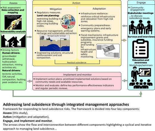
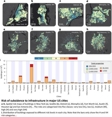
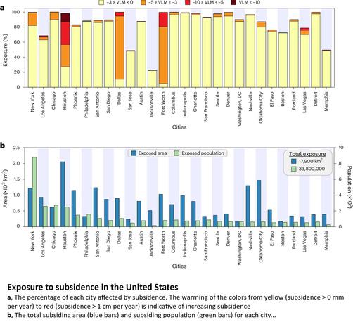
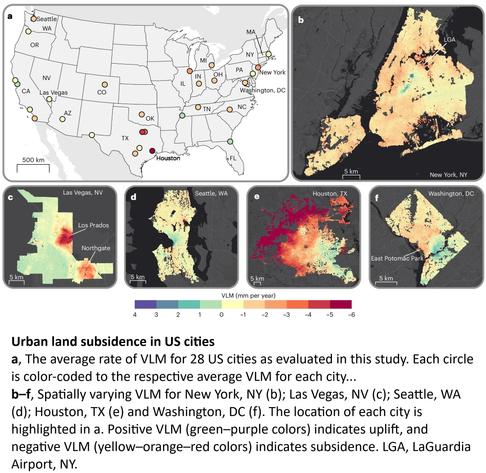
Land Subsidence Risk To Infrastructure In US Metropolises
--
https://www.eurekalert.org/news-releases/1082763 <-- shared technical article
--
https://doi.org/10.1038/s44284-025-00240-y <-- shared paper
--
#GIS #spatial #mapping #remotesensing #water #hydrology #groundwater #extraction #risk #hazard #damage #infrastructure #USA #city #metro #land #subsidence #cost #impact #engineering #environment #socioeconomic #urban #spatialanalysis #spatiotemporal #spatialdensity #geology #engineeringgeology #buildings #transportation #humanimpacts #regulation #policy #planning #urbanplanning #mitigation #response
Decade of Research in Macleay Caves: Key Findings and Future Directions
Around a decade ago, thanks to a government committee that I was a member of, I was encouraged to consider improving our understanding of the caves and karst in the Macleay karst region of Australia*.
*Roughly midway between Sydney and Brisbane on the east coast of Australia.
That led to me to working with the Kempsey Speleological Society (KSS) members, the local experts on the caves and karst. Some of the KSS designed some climate and hydrology monitoring projects that they were interested in, to know more about the caves and karst in the region. The KSS Cave Studies Team was born.
Forward on over a decade… the KSS has become ‘my’ caving club. A decade ago, the KSS Cave Studies Team designed sampling programs to understand cave climate, and some of the complex hydrology of the Macleay karst. The cave climate research is still unpublished, but yes, we have some very long term climate data.
The first hydrology paper, using drip loggers placed in caves in an altitudinal transect through the Macleay karst, was published in the Journal of Hydrology in 2020, which was interesting for anyone interested in how much rainfall is needed to replenish the groundwater in the regions. But it was only the first step in understanding the karst hydrology in the region.
Which sets the scene for this new pre-print, with the title “Identification of synoptic climate and drought controls on rainfall stable water isotopic composition in the Macleay karst region of eastern Australia”. It is online here and open for community and research comments.
The story of the paper goes something like this…
The KSS desgn their research question a decade ago, and we implemented the monitoring programs to get some answers (hopefully!). Low cost solutions were great, and water stable isotope analyses of spring water samples was one that I proposed as a natural tracer and something that could KI could help with to enable the KSS Cave Studies Team to understand the karst hydrology of the region. That would require grab samples of water from springs and creeks in the region. And rainfall samples to measure the isotopic composition of the ‘input’. The KSS Cave Studies Team were ‘in’!
Please head over to the pre-print to read all about the results, with rainfall isotope data and spring water data from 2017 to 2023. The pre-print has all the formal acknowledgements and research credit statements, but they are quite formal. So here…
I would like to thank Sophia Meehan, without whom, none of this would have happened.
In the KSS, special thanks to Allister Gee for leading the ‘big picture’ monitoring program design.
Philip Holberton, who I never knew as a cave explorer, but I did as a retired former GP and the KSS journal editor, managed monthly IAEA grade water isotope sampling from his property for three years from 2017-2020, including through bushfire evacuations. Vale Philip. He never got to see the results of his meticulous sampling.
Glen Bowman, one of the founding KSS Cave team, who took on the rainfall sampling and went to event sampling from his property from 2020 and is ongoing. Data from his samples through to 2023 are also in the pre-print.
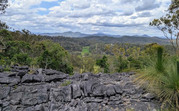
And it is a huge effort to collect the karst spring and creek samples. Thanks to the whole KSS Cave Studies Team for collecting these samples. I have been on many of these club caving trips, and I’ve got to all the sample sites. This is tough, tough country to move through, and at the same time one of the most beautiful landscapes I have have worked in. Thank you to the team for agreeing to pack sample bottles on all those caving expeditions
https://papers.ssrn.com/sol3/papers.cfm?abstract_id=5497377
#caves #earthScience #environment #environmentalScience #groundwater #hydrology #karst #research #science
Groundwater news from day 2 at #IAH2025 in Naarm / Melbourne.
NGROS presentations by Wendy Timms and Akhi Kumar on groundwater recharge.
Find out more on NGROS at https://gi.copernicus.org/articles/13/117/2024/
Why not establish something similar in your country?
Anyone knows about analyses of contaminants in groundwater with high temporal resolution?
Grassroots efforts rally to save Old Cairo's Islamic heritage from rising waters. #groundwater #inundation #water #infrastructure #history https://www.newarab.com/features/saving-old-cairos-heritage-rising-waters
Grassroots efforts rally to save Old Cairo's Islamic heritage from rising waters. #groundwater #inundation #water #infrastructure #history https://www.newarab.com/features/saving-old-cairos-heritage-rising-waters
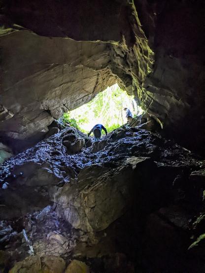
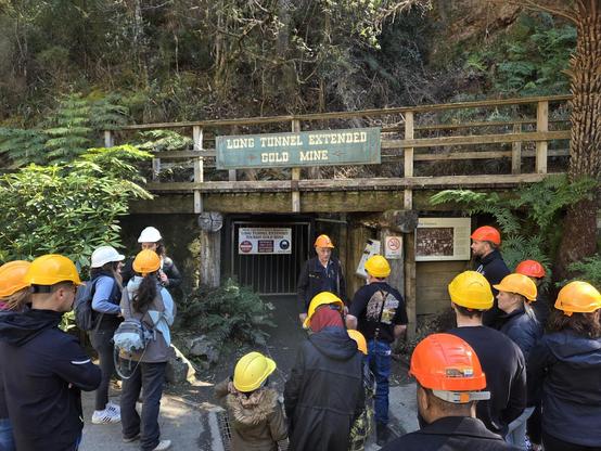
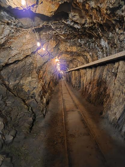
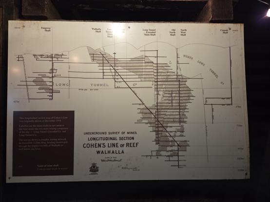
Day one of the #IAH2025 Congress and the fieldtrip led by Wendy Timms at the Walhalla Long Tunnel Heritage Gold Mine.
What has this to do with groundwater? Mines like this are observatories of groundwater recharges in action. And we have had loggers in the mine recording when recharge events occur. And at Walhalla, just like our other monitoring sites across Australia, there are not many recharge events, and rainfall in the top 10% is needed. In other words, only rain events of 20 mm or more might replenish our groundwater resource.
Walhalla is featured in this open access paper led by Stacey Priestley with myself, Marilu Melo Zurita, Margaret Shanafield, Wendy Timms and Martin Andersen
https://agupubs.onlinelibrary.wiley.com/doi/full/10.1029/2024GL113503
Thanks to the Australian Research Council (ARC) for the infrastructure funding in 2022 that made this possible.
New paper alert!
We determined the amount of rainfall needed for water to move towards the groundwater. Working at Wombeyan Caves, we identified potential recharge events by logging cave drip water percolating into a shallow cave.
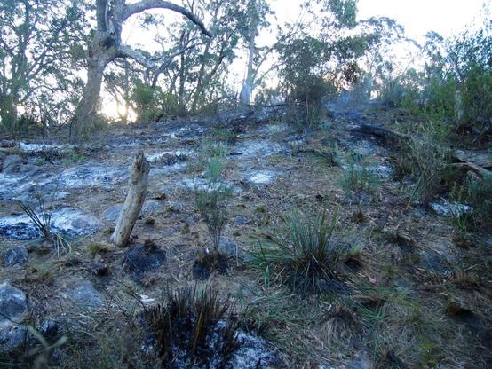
During our monitoring, an intense fire occurred above the cave, and we were able to quantify any change in the amount of rainfall necessary to generate recharge before and after the fire. Guess what, it changed!
Read more about our new paper led by Christina Song and @michcampbell here...
https://andy-baker.org/2025/09/14/understanding-groundwater-recharge-impact-of-rainfall-and-fires/
#water #groundwater #caves #hydrology #Science #research #academia
Understanding Groundwater Recharge: Impact of Rainfall and Fires
Groundwater can be replenished by rainfall that percolates from the surface to the water table. The amount of rainfall that is needed to generate this groundwater recharge is hard to measure. We determined this rainfall amount by identifying recharge events as water percolates from the surface, through a cave. During our monitoring, an intense fire occurred above the cave, and we were able to quantify any change in the amount of rainfall necessary to generate recharge before and after the fire.
Above the cave, the morning after the fireThis new paper in the journal Hydrology and Earth System Sciences was led by Christina Song, and co-authored by myself and Micheline Campbell. It can be read and downloaded (Open Access) at https://hess.copernicus.org/articles/29/4241/2025/
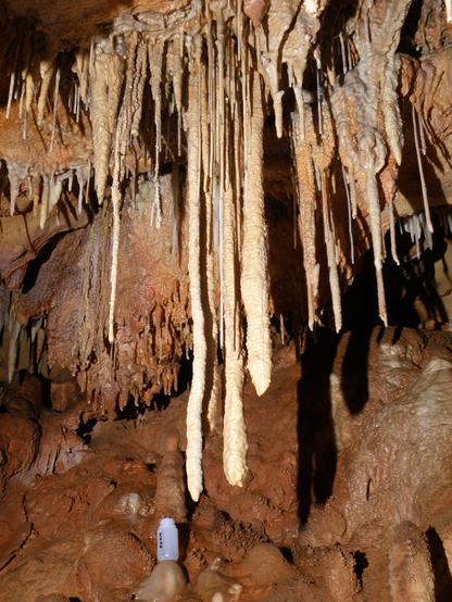
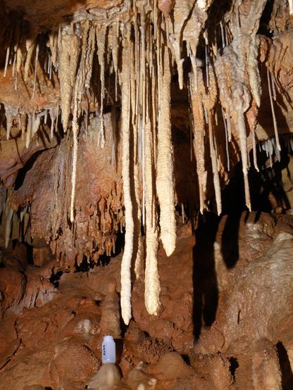
We quantified the amount of rainfall needed for water to percolate into the cave, the rainfall recharge threshold, using drip loggers. Our research cave was a near-surface cave: Wildman’s Cave at Wombeyan, southeast Australia, approximately 4 m below the land surface and comprising a 30° slope with 37 % bare rock.
Wildman’s Cave (photo credit: Andrew Baker, NPWS)In this paper, we reanalysed data originally published by Bian Fang and colleagues in Science of the Total Environment In just over two years of monitoring, the drip loggers recorded 42 potential recharge events. Water movement to the cave was rapid, with percolation into the cave occurring within 48 h of rainfall.
Using daily rainfall data that was collected at the site, we could calculate that the median 48 h rainfall needed to generate recharge was around 20 mm. However, this changed after the fire. The median 48 h rainfall needed to generate recharge was around 22 mm before the fire and around 16 mm after the fire, with the decrease in rainfall recharge most noticeable starting 3 months after the fire.
At Wildman’s Cave, we infer that soil water storage, combined with the generation of overland flow over bare limestone surfaces, is the pathway for water movement to the subsurface via fractures and that these determine the rainfall recharge threshold.
Immediately after the fire, surface ash deposits initially retard overland flow, and after ash removal from the land surface, soil loss and damage decrease the available soil water storage capacity, leading to more efficient infiltration and a decreased rainfall recharge threshold.
Our results for the rainfall recharge threshold and the number of potential recharge events at Wildman’s Cave are consistent with those published recently by Stacey Priestley and colleagues from other caves in water-limited Australia. It seems that at least 20 mm of rain in 48 hours is needed for recharge to occur almost everywhere we have measured.
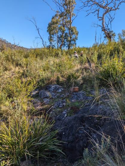
Above Wildman’s Cave in 2023
#caves #karst #environmentalScience #research #science #earthScience #groundwater #environment #sustainability
Australasian Cave and Karst Management Association Conference, Wellington Caves
Last week, the ACKMA conference was hosted at the wonderful Wellington Caves & Holiday Park.
I was fortunate to both present the lastest groundwater research results, and also and co-lead some cave tours with the delegates.
That's not in my usual day job!
You can read more about how it all went here....
