
Aquatic Reflectance Derived From Sentinel-2 Multispectral Imager Data For Inland Waters In The Conterminous United States
--
https://doi.org/10.1002/lol2.70112 <-- shared paper
--
https://doi.org/10.1016/j.watres.2025.124432 <-- shared ‘related’ paper
--
🚨 🛰️
#GIS #spatial #mapping #fedscience #openscience #publicgood #fedservice #water #hydrography #hydrology #remotesensing #satellite #sentinel #spatialanalysis #usecase #surfacereflectance #waterquality #waterresources #spatiotemporal #change #aquatic #ecosystems #earthobservation #atmospheric #correction #inlandwater #freshwater #turbidity #opendata
#USGS | #ESA
#fedservice


Mapping What Matters - How the USGS delivers actionable geospatial information to address Federal priorities and support CBP Goals
--
https://gis.chesapeakebay.net/gsat/priorities/ <-- shared technical article
--
https://www.chesapeakebay.net/files/documents/CBWA-2025-IV-Final-Facing.pdf <-- shared Revised Chesapeake Bay Watershed Agreement
--
https://www.baltimoremagazine.com/section/travel/chesapeake-bay-maryland-natural-treasure-inspires-how-we-eat-play-live/ <-- shared technical media article – “The Wonder Of The Bay”
--
#GIS #spatial #mapping #USGS #fedscience #fedservice #publicgood #GeospatialScienceandApplicationsTeam #GSAT #ChesapeakeBay #USA #partnership #spatialanalysis #spatiotemporal #watershed #water #hydrology #conservation #restoration #planning #polict #management #StrategicPlan #usecase
#USGS


A ‘Waylaid' Teaching Diorama – USGS “Geology For Land Use”
--
For about 3 years, this gorgeous diorama has ‘just’ been sitting in a corner of a (common) hallway.
I can’t help but wonder its history:
• What prompted its creation?
• Who was the artisan (truly!) that created it and used those components and focus?
• When was it created? (late 1960s as an educated guess????)
• Why was it seen as useful / in what setting? (as I am sure it was)
• How was it funded?
(never mind that I want to claim it for my office, space notwithstanding…)
#geology #landuse #trainingaid #education #diorama #oldschool #fedscience #fedservice #education #technical #professional #spatial #landform #geomorphology #usecase #appliedscience #geoscience #USGS
@USGS

Good To Be (Back) At #GeoWeek
--
https://www.geo-week.com/
--
Volunteering at the #USGS booth, meeting & re-meeting fellow spatial professionals, seeing all the sweet hardware, and more...
(moving next year, so taking advantage of it being local to me...)
#GIS #spatial #mapping #conference #Denver #professional #hardware #professional #NGTOC #3DHP #3DEP #opendata #fedscience #fedservice
@GeoWeeK


From Space To Field - Putting satellite insights into growers’ hands [OpenET]
--
https://irrigationtoday.org/features/from-space-to-field/ <-- shared technical media article
--
https://etdata.org/ <-- shared OpenET home page
--
https://www.nasa.gov/image-article/openet-satellite-based-water-data-resource/ <-- shared NASA technical article
--
https://youtu.be/Rbobf6aurLs?si=Q0kN9eiZH0gT8O5m <-- shared OpenET overview video
--
#OpenET #openscience #opendata #publicgood #publicservice #nonprofit #fedscience #fedservice #evapotranspiration #ET #Landsat #OLI #OperationalLandImager #groundwater #water #hydrology #spatialanalysis #spatiotemporal #agriculture #USA #farming #waterresources #watermanagement #planning #watersecurity #satellite #remotesensing #earthobservation #model #modeling #irrigation #metrology #raster #cost #economics #efficiency #foodproduction #mobileapp #FARMS #view #download #usecase #reporting
#OpenET #USGS #USDA @NASA #USGS_EROS


"Who Is Government? - The Untold Story of Public Service"
--
https://www.goodreads.com/book/show/219551344-who-is-government-the-untold-story-of-public-service <-- shared book details
--
https://www.youtube.com/live/GuA_TUxi-5k?si=WbxW5iCGbzVMZNYW <-- shared video overview from the author
--
My other ½ heard about this book in her #NOAA #bookclub - and got it for me for Xmas! 😀
I am very much looking forward to this series of essays...
#fedservice #fedscience #readingforpleasure #publicservice #publicgood #government #civilservice #society #resource #workers #stories #businessofgovernment #consequences #returnoninvestment #usecase

FEMA Mobile App [free] [USA]
--
https://www.ready.gov/ <-- shared Ready-iness FEMA web site
--
“Download the newly updated FEMA App to get preparedness strategies and real-time weather and emergency alerts…”
--
“Launched in February 2003, Ready is a National public service campaign designed to educate and empower the American people to prepare for, respond to and mitigate emergencies and disasters...
Ready… ask individuals to do four key things:
• Stay informed about the different types of emergencies that could occur and their appropriate responses
• Make a family emergency plan.
• Build an emergency supply kit.
• Get involved in your community by taking action to prepare for emergencies…”
#risk #hazard #geohazard #flood #fire #winter #extremeweather #fedscience #fedservice #publicgood #publicservive #taxpayer #safety # #preparedness #emergencies #disasters #app #phone #hazardreadiness #readiness #free #FEMA
@FEMA


Fire Event Explorer [NASA]
--
https://www.earthdata.nasa.gov/dashboard/tools/fire-event-explorer <-- shared NASA mapping resource
--
“This tool visualizes near real-time (NRT) satellite-based fire perimeters, active portions of fire perimeters (fire lines), and active fire pixel detections for the current year.
Use the bottom panel to select different date ranges or subset fires by size, duration, or intensity. Click on an individual fire to visualize the time series of fire growth every 12 hours and create video outputs in GIF or WebM formats.
These fire tracking data are from the Fire Event Data Suite (FEDS) algorithm. Find out more:
• FEDS data source documentation
• OpenVEDA documentation
• Earthdata VEDA dashboard..."
#GIS #spatial #mapping #VEDA #nearrealtime #satellite #remotesensing #fire #wildfire #extremeweather #perimeter #download #detection #monitoring #FireEventExplorer #FEDS #NRT #OpenVEDA #earthdata #VIIRS #landform #opendata #fedscience #fedservice #risk #hazard #infrastructre #NASA
@nasa


Sentinel-2 Based Estimates Of Rangeland Fractional Cover And Canopy Gap Class For The Western United States
--
https://doi.org/10.1038/s41597-025-06160-9 <-- shared paper
--
https://rangelands.app/products/rap10m/ <-- shared 10 metre Range Analysis platform overview
--
[aside & totally anecdotal - I have ridden on the road in that last picture - near Sheridan, WY]
--
#GIS #spatial #mapping #fedscience #fedservice #feddata #opendata #usecase #publicgood #rangeland #ecosystems #monitoring #spatialanalysis #spatiotemporal #US #USA #vegetation #satellite #remotesensing #earthobservation #Sentenial #Sentenial2 #canopy #fractionalcover #canopygap #landcover #landuse #grass #pinyon #juniper #opendata #raster #USWest #WesternStates #landsurface #tools #fielddata #model #modeling #BLM #USDA #statistics #geostatistics #RangelandAnalysisPlatform
@USDA @BLM


Thirty Years of the U.S. National Land Cover Database - Impacts and Future Direction
--
https://doi.org/10.14358/PERS.25-00121R2 <-- shared paper
--
“Editor's choice article for the October Issue of Photogrammetric Engineering and Remote Sensing.”
#GIS #spatial #mapping #remotesensing #opendata #earthobservation #landcover #USA #NLCD #MRLCC #history #datacollection #impervioussurface #classifaction #landform #forestcanopy #fedscience #fedservice #deeplearning #AI #spatialanalysis #change #monitoring #usecase #research #landmanagement #management #policy #planning #support #agriculture #urbanplanning #environment #ecosystems #biodiversity #conservation #water #hydrology #humanhealth #risk #hazard #soils #naturalhazard #spatiotemporal #landchange #forestry #watermanagement #waterquality #publicsafety #groundwater #NCLA #wildfire #stormwater #extremeweather
#USGS #EROS #NASA #USFS


U.S. Geological Survey [#USGS] Geomagnetic Variometer Data - Capitalizing On Seismic Infrastructure
-
https://doi.org/10.1785/0220250185 <-- shared paper
--
#geomagnetic #geomagnetism #USGS #USA #CONUS #seismology #seismograph #measurement #spatialanalysis #spatial #stations #SeismographicNetwork #magneticfield #readings #spatiotemporal #magnetometer #collabration #spaceweather #risk #hazard #colocation #magneticstorm #earthquake #interdisciplinary #research #sampling #multidisciplinary #fielddata #mapping #GIS #cohosted #corrleation #sampling #fedscience #fedservice #publicgood
#USGS


Have You Ever Wondered What A New Concrete Stilling Well [stream gauge] Looked Like?
--
H/T Roy Socolow, USGS
"While doing research on the USGS stream gaging program for a local presentation, [he] found this beautiful image of a classic stilling well from the Kentucky archives. Intakes and valve stems in perfect condition, hand pump and flush tank ready to fill, no kerosene or funky well water smell, and the clock weights on the Stevens recorder have plenty of travel room. Makes them] think of the good old days climbing down well ladders to “muck out” wells. Many of these “tanks” of instrument shelters still exist with either working intakes or as converted bubble gages. Many others have been decommissioned due to safety issues (falling or confined space hazards). Thanks to the men of the #CCC and #WPA..."
#gage #streamflow #instrumentation #hydrology #measurement #history #waterresources #stillingwell #recording #USGS #fedscience #fedservice
@USGS

Even though we are furloughed, the boss arranged a breaking of the bread (no GFE involved); it was a pleasure to see everyone I work with!
#fedservice #fedscience

The Next Landsat - Mission Turning Point? [Landsat Next, descoped mission, etc]
--
https://doi.org/10.1016/j.rse.2025.115087 <-- shared paper / commentary
--
https://www.fgdc.gov/ngac/meetings/feb-2025/lag-usgs-nli-update-final-version-february-20-2025.pdf <-- shared USGS FY25 Q! Update on Landsat and Sustainable Land Imaging, National Geospatial Advisory Committee
--
Https://Www.Natechcorp.Com/_Files/Ugd/Ac01f5_F79deb4d508547c984ccc4a6090c54ab.Pdf <-- shared 2023 report – “Economic Valuation Of Landsat And Landsat Next”
--
https://svs.gsfc.nasa.gov/14262 <-- 2022 NASA Landsat Next overview video
--
#GIS #spatial #mapping #remotesensing #earthobservation #EO #usecase #Landsat #satellite #history #historic #LandsatNext #Design #Userneeds #CurrentStatus #budget #funding #planning #fedscience #fedservice #dataquality #continuity #community #opendata #openscience #observation #requirements #LNext #capability #VSWIR #design #future #longterm #risk #hazard #descoped #restructured #economicbenefit #EconomicValuation #value #valueformoney #USGS #NASA #EROS


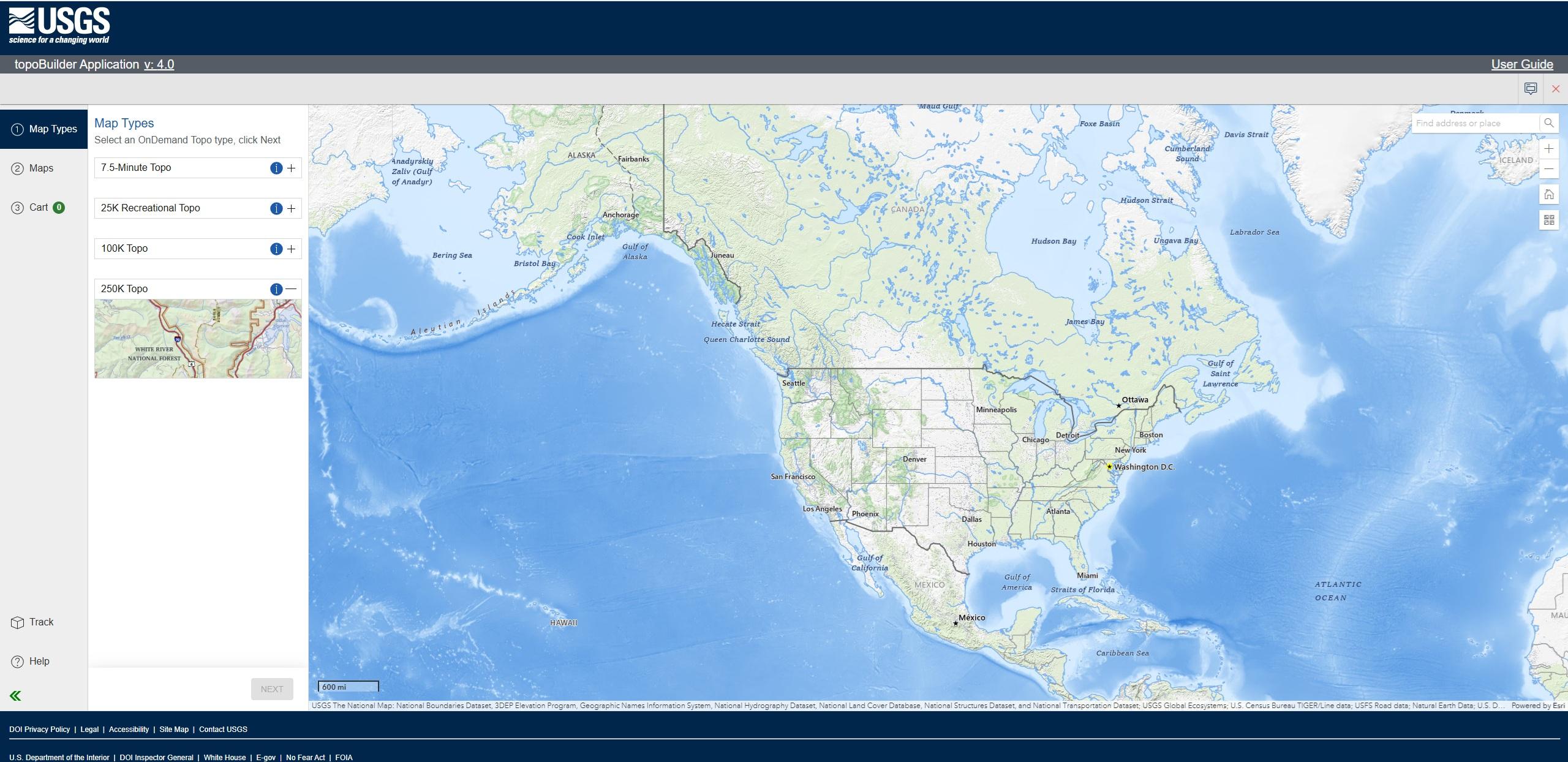
Latest #USGS Map-Product Release - 250K Topo OnDemand Topo Products Now Available Through The Topobuilder Application
--
https://www.usgs.gov/programs/national-geospatial-program/news/regional-view-reliable-data-introducing-usgs-250k-topo <-- USGS product announcement page and topoBuilder custom map construction application access
--
“The U.S. Geological Survey (USGS) has launched the 250K Topo, a new digital map product designed to support regional planning, land and resource management, and emergency response coordination…”
--
#GIS #spatial #mapping #USGS #OnDemandTopo #NGP #topoBuilder #OnDemand #250KTopo #Geospatial #TopographicMaps #GIS #MappingInnovation #OpenData #Maps #NGTOC #NGP #custom #opendata #latest #spatialdata #topomap #fedservice #fedscience #publicgood
@USGS


NOAA Supports Sargassum Response In Puerto Rico
--
https://coastalscience.noaa.gov/news/noaa-supports-sargassum-response-in-puerto-rico/ <-- shared technical article
--
https://repository.library.noaa.gov/view/noaa/65792 <-- 2024 NOAA: ‘Nearshore Sargassum Management: Policy Analysis and Agency Gaps Assessment’
--
H/T NOAA Centers for Coastal Ocean Science
#HarmfulAlgalBloom #HAB #PuertoRico #USA #coast #coastal #damage #cost #risk #hazard #sargassum #algae #impacts #accumulation #stateofemergency #wildlife #ecosystems #emergency #shoreline #innundation #fisheries #infrastructure #damage #socioeconomic #humanimpacts #habitat #publichealth #fedservice #fedscience
@NOAA @NCCOS


The U.S. Geological Survey [USGS], The U.S. Department Of Defense [DoD], And The U.S. Intelligence Community [various] - 100 Years Of Mapping And Remote Sensing Collaboration, 1879–1979
--
https://pubs.usgs.gov/publication/cir1552 <-- link to USGS circular
--
#GIS #spatial #mapping #maps #sharing #spatialanalysis #history #military #intelligence #geointelligence #GEOINT #remotesensing #satellite #earthobservation #datasharing #technology #mission #fedservice #fedscience #wholeofgovernment #interactions #sectors #collaboration #interagency #interdepartmental #governmentbranches
@USGS DoD #CIA #FBI


First Ever Images from the Vera Rubin Telescope [Chile]
--
https://youtu.be/tu4cpaDZ68g?si=FaeVBYNRYIbEfqiU <-- shared technical video
--
https://rubinobservatory.org/ <-- Rubin Observatory home page
--
“The Vera C. Rubin telescope has just [mid-2025] released its first images, and they’re spectacular…
On a mountain in Chile, the Vera C. Rubin Observatory, with its massive 3.2-billion-pixel camera, is capturing images that rival those from the James Webb Space Telescope. Get ready to see some of the most stunning astronomical images ever taken as [they] explore how this groundbreaking project will help us unlock the secrets of the universe. This is just the beginning...”
#verarubin #fedscience #fedservice #Coquimbo #Chile #LegacySurveyofSpaceandTime #LSST #Andes #telescope #remotesensing #image #imagery #astronomy #astronomical #observation #spatialanalysis #spatiotemporal #extraterrestrial #research
@NSF @DOE @SLAC


[USGS] FORT Science In Action – Science In Support Of Invasive Reptile Management In The Greater Everglades
--
https://www.usgs.gov/centers/fort-collins-science-center/news/fort-science-action-part-7-science-support-invasive <-- shared technical article
--
#remotesensing #florida #everglades #restoration #burmese #python #snake constrictor #impacts #invasive #species #reptiles #loss #mammal #tegus #ecosystems #habitat #plants #vertebrate #carnivore #feral #threatened #research #culling #risk #hazard #threat #AI #imagery #UAS #GIS #spatial #mapping #DNA #sampling #surveillance #cost #ecology #damage #trapping #collaboration #scaleable #control #biocontrol #fedscience #fedservice #management #protection #swamp #wetland #grasslands #geomorphology #geomorphometry #water #hydrology #native #species #USGS #NPS
@USGS @NPS


USGS Scientists Are Providing Critical Data To Support Emergency Response Efforts As Glacier Flooding Affects Juneau, Alaska.
--
https://www.linkedin.com/posts/usgs_usgs-scientists-are-providing-critical-data-activity-7361514160343408640-HMuf <-- shared #USGS LinkedIn post
--
https://apps.usgs.gov/hivis/camera/AK_Glacial_Lake_near_Nugget_LOOKING_UPSTREAM_GLACIER_VIEW <-- views at USGS HIVES website
--
https://www.juneauflood.com/#/home <-- Juneau Glacial Flood Dashboard, University of Alaska, SE
--
https://www.juneauflood.com/#/flood-map <-- Juneau Glacial Flood Dashboard / Flood Map
--
https://www.weather.gov/ajk/suicideBasin <-- National Weather Service (NWS) monitoring and current conditions
--
#GIS #spatial #monitoring #GLOF #Alaska #climatechange #glacier #melting #Juneau #floodmaps #forecasting #innundation #glacial #outburstfloods #SuicideBasin #Mendenhall #Lake #Valley #engineering #mitigation #HESCO #risk #hazard #engineeringgeology #cost #impacts #economics #residential #naturaldisaster #infrastructure #residential #homes #fedscience #fedservice #opendata #fedopendata #publicsafety #publicgood #water #hydrology #flood #flooding
@USGS @nws


Client Info
Server: https://mastodon.social
Version: 2025.07
Repository: https://github.com/cyevgeniy/lmst