Emulator Debugging: Area 5150's Lake Effect
https://martypc.blogspot.com/2025/05/emulator-debugging-area-5150s-lake.html
#HackerNews #Emulator #Debugging #Area #Lake #Effect #Emulator #Debugging #Area5150 #LakeEffect #TechNews #GamingCommunity
Emulator Debugging: Area 5150's Lake Effect
https://martypc.blogspot.com/2025/05/emulator-debugging-area-5150s-lake.html
#HackerNews #Emulator #Debugging #Area #Lake #Effect #Emulator #Debugging #Area5150 #LakeEffect #TechNews #GamingCommunity
Plus de quatre trombes d'eau ont été observées l'une à côté de l'autre à Bartın Amasra, au bord de la mer Noire. #lakeeffect #neige #Turquie
https://twitter.com/wintimet/status/1893335793294254204
Original tweet: https://twitter.com/meteosuisse/status/1893593880613822606
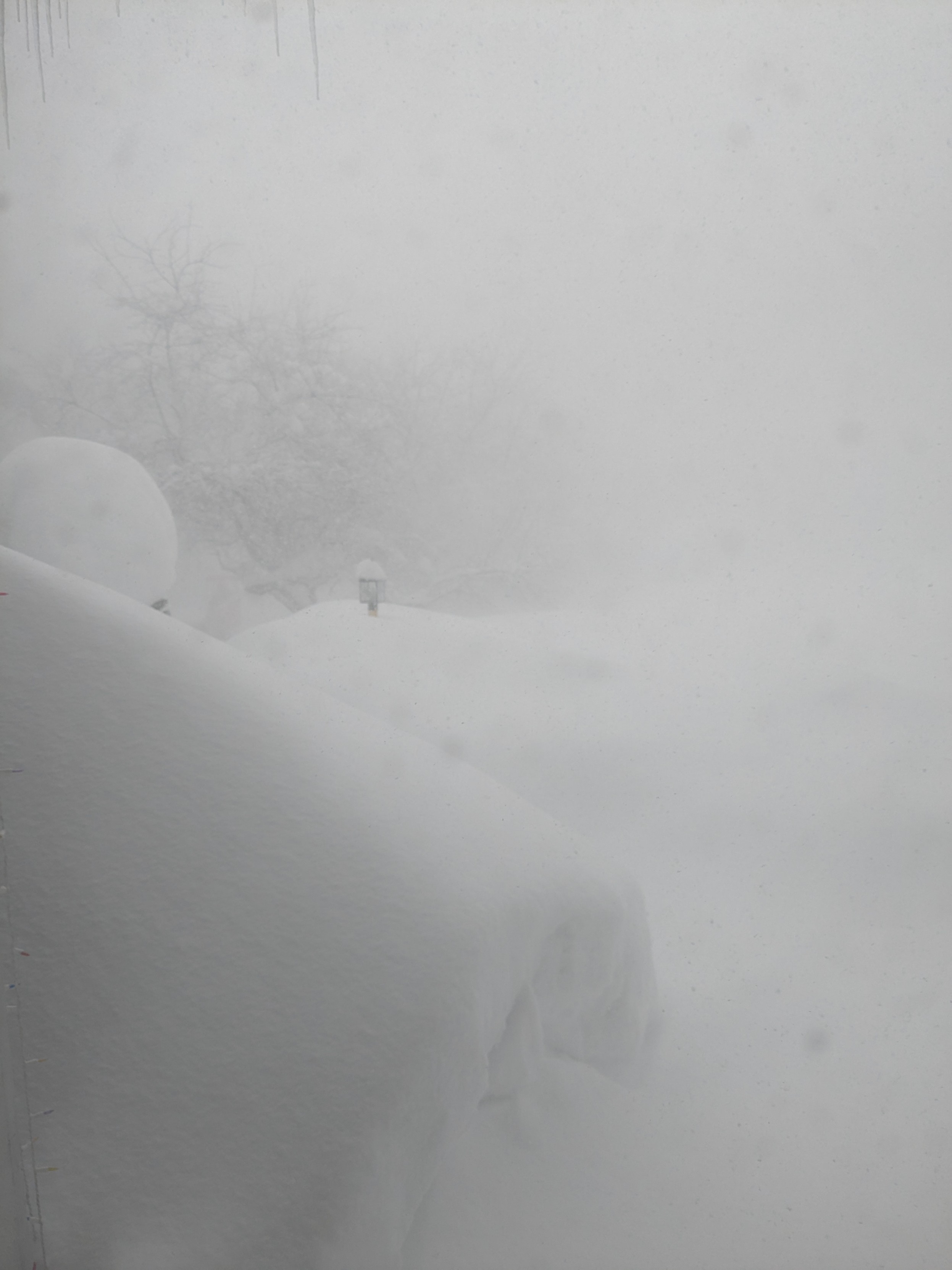
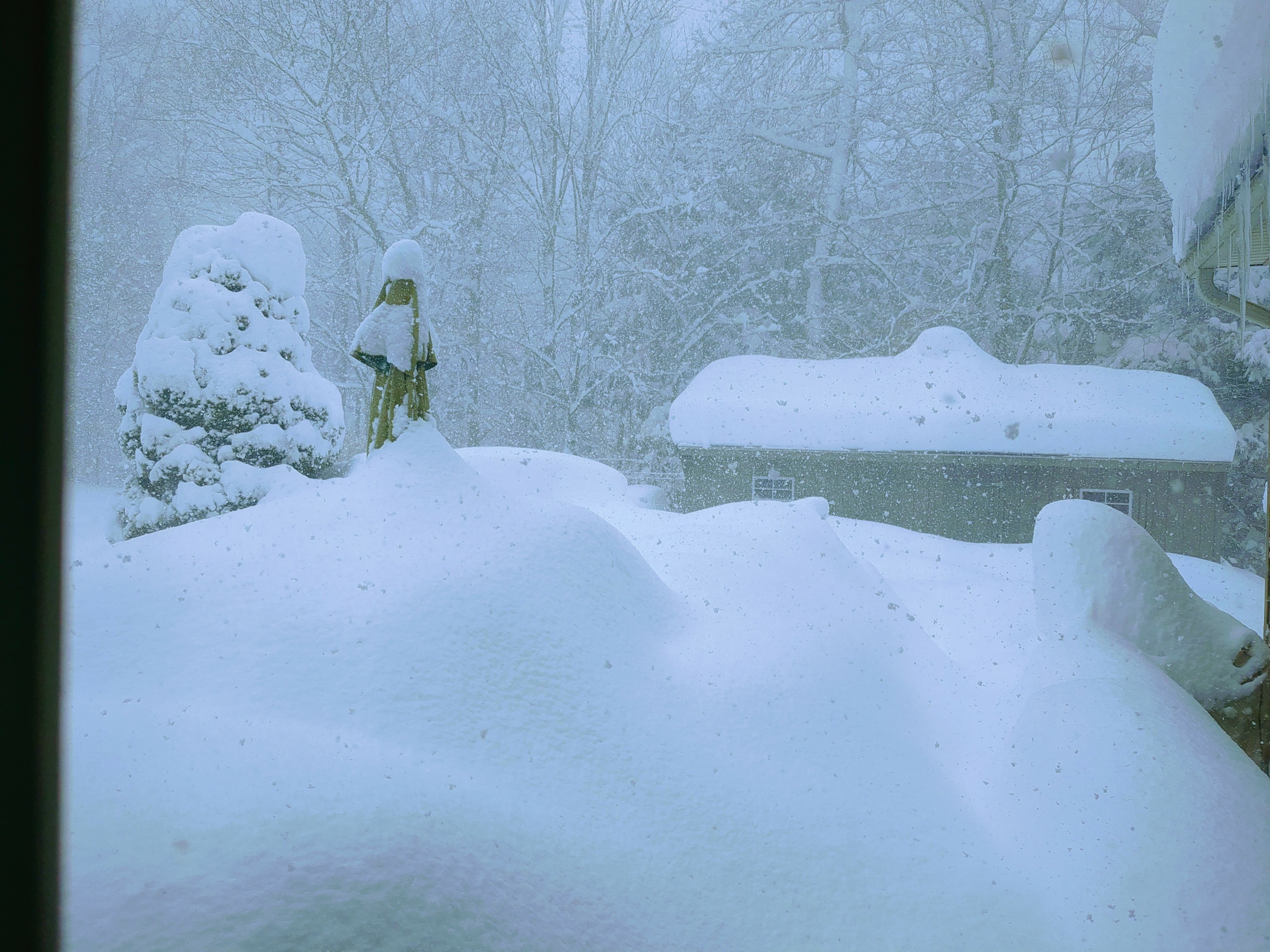
Today begins the digging. We have had in excess of 100" / 2.5m of snowfall over the last week. That bit of blue above the garage is the first sky I have seen in about that same period.
It is not coincidental that as I type #snow I am not thinking "hashtag snow" but "go pound snow."
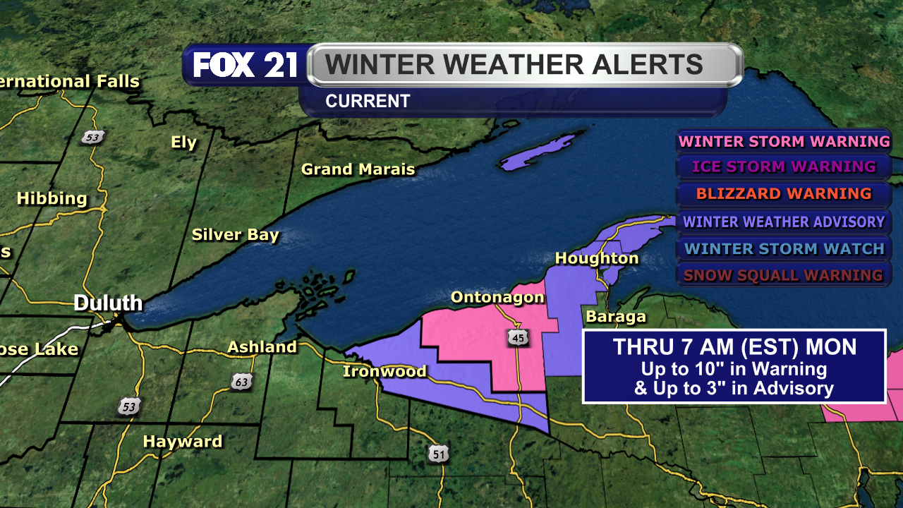
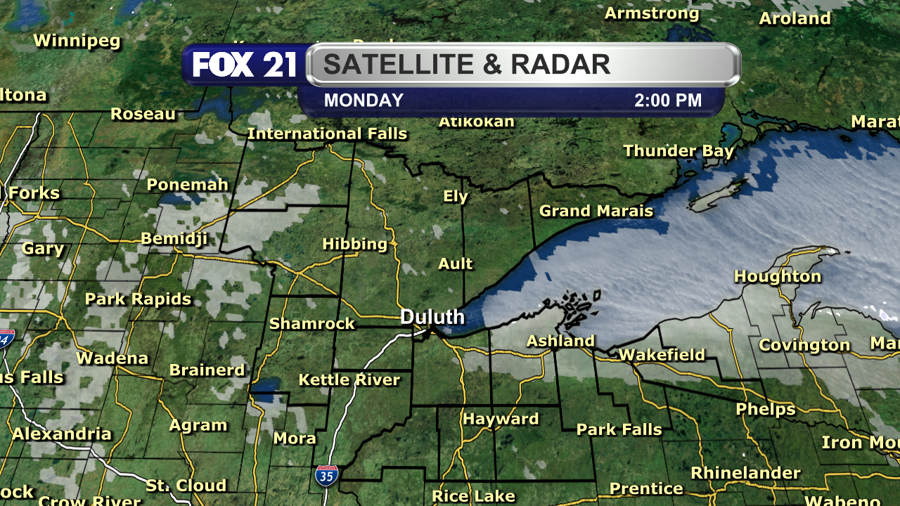
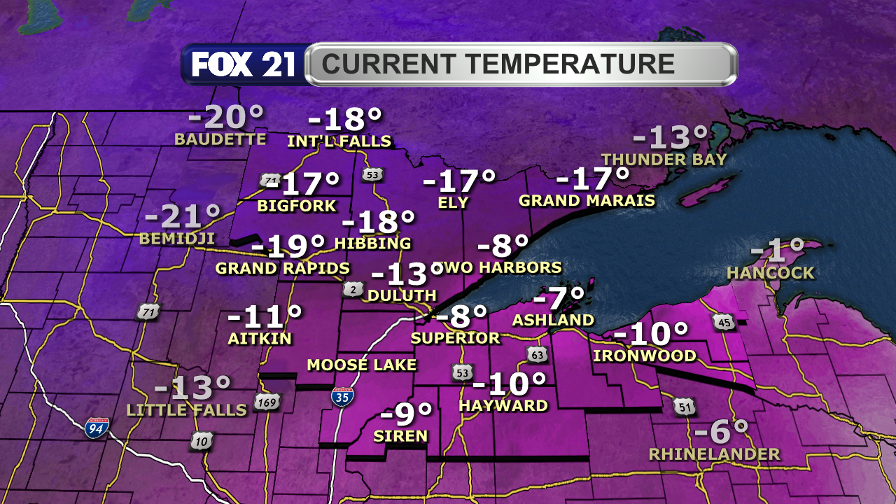
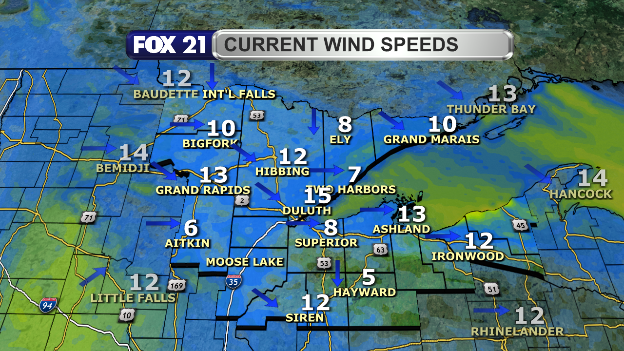
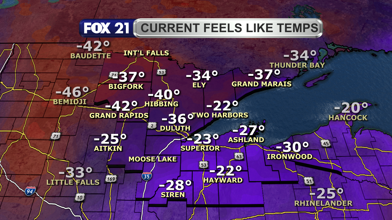
NORTHLAND FORECAST FOR FEBRUARY 17, 2025:
The #arctic air is back in the #Northland.
Lows Sunday night will be as #cold as -25°, with #windchills as low as -45° through Monday morning. #Temperatures will hover around 0° for highs Monday afternoon, with a northwest #breeze keeping it feeling below zero.
#Lakeeffect #snow #showers continue for the #UpperPeninsula, with decreasing #clouds elsewhere.
VIDEO: https://www.fox21online.com/2025/02/16/sunday-evening-northland-forecast-2-16-2025/
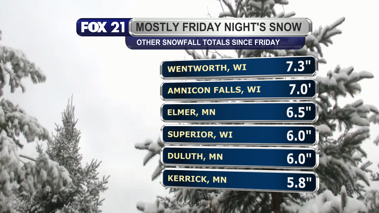
WEEKEND SNOWFALL TOTALS:
The #snow #showers across the #Northland since Valentine's Day have contained big and fluffy #snowflakes.
Thanks to a northeast #breeze creating #lakeeffect bands, and you get some decent #snowfall totals. Some spots saw 9 to 12 inches of #accumulation.
More lake effect snow showers continue for the #UpperPeninsula through Monday.

Happy #Sunday afternoon from the #Northland!
The weekend #snow #showers are wrapping up for most of the region. Only #lakeeffect bands for the
#UpperPeninsula remain.
It will be back to the #arctic #cold of #winter the next several days, starting tonight.
Golly.... Maybe we will win the snow bowl against Buffalo this year ❄️❄️❄️❄️ #LakeEffect #Snow #Syracuse #Oswegocounty
NORTHLAND FORECAST FOR JANUARY 31, 2025:
#Clouds will increase across the #Northland Thursday night, but we remain #dry and winds remain light with lows in the teens and low 20s.
Friday will see a mixture of #sunshine and clouds with a few #lakeeffect #snow #showers along the #SouthShore snowbelt. #Temperatures will be closer to #seasonal with highs in the 20s and low 30s.
VIDEO: https://www.fox21online.com/2025/01/30/thursday-evening-northland-forecast-1-30-2025/
NORTHLAND FORECAST FOR JANUARY 23, 2025:
Wednesday night in the #Northland will be #cold with #temperatures below zero for nearly all of us. A #breezy northwest #wind will make it feel as cold as -30°.
Other than #lakeeffect along the #SouthShore snowbelt, skies will #clear of #clouds and provide plenty of #sunshine Thursday with lighter winds. Highs will remain #cool in the single digits and low teens.
VIDEO: https://www.fox21online.com/2025/01/22/wednesday-evening-northland-forecast-1-22-2025/
NORTHLAND FORECAST FOR JANUARY 21, 2025:
Monday night will be the last of the #extreme #cold in the #Northland. #Temperatures will range from 15 to 35 below, with #windchills as low as 45 below.
A shift in #winds to the southwest will end the #lakeeffect #snow #showers for the South Shore, allowing everyone to enjoy some #sunshine by Tuesday afternoon. Highs will be in the single digits below zero.
VIDEO: https://www.fox21online.com/2025/01/20/monday-evening-northland-forecast-1-20-2025/
Happy #Monday afternoon from the #Northland!
The #weather to start a new week is pretty much a repeat of Sunday...even slightly #colder by a few degrees.
#Temperatures remain below zero, with dangerous #wind #chills.
The #sun is out for most, but #lakeeffect along the #SouthShore persists.
NORTHLAND FORECAST FOR JANUARY 20, 2025:
#Cold #temperatures continue across the #Northland Sunday night with lows 10 to 25 below, and highs Monday 5 to 15 below. Any #breeze will make it feel between 25 and 50 below.
#Lakeeffect #snow #showers will continue along the #SouthShore region. Everyone else will have partly #cloudy skies.
VIDEO: https://www.fox21online.com/2025/01/19/sunday-evening-northland-forecast-1-19-2025/
Are you lacking in #Winter Wonderland? Here, share some of mine. I have extra.
#snow #LakeErie #cold #LakeEffect #WNY #NYState #HereTakeMine
NORTHLAND FORECAST FOR JANUARY 14, 2025:
#Lakeeffect #snow #showers continue along the #SouthShore Monday night, with highest #snowfall east of Ashland.
The rest of the #Northland will see decreasing #clouds with #temperatures below zero for lows. #Wind #chills will be as low as -25°.
Tuesday will see skies become #clear, winds calm, and highs in the single digits and low teens.
VIDEO: https://www.fox21online.com/2025/01/13/monday-evening-northland-forecast-1-13-2025/
Happy #Monday afternoon from the #Northland.
The bitter #cold of #winter has returned, with a #breeze making it feel as cold as -25° in spots.
At least we have some #sunshine to make it look better, but #lakeeffect #snow on the #SouthShore snowbelt persists.
NORTHLAND FORECAST FOR JANUARY 13, 2025:
#Arctic air returns to the #Northland. #Temperatures will be below zero for lows Sunday night, with single digits for highs Monday. A #breezy northwest #wind will keep wind #chills as low as -30°.
#Snow #showers will persist near #LakeSuperior through Monday night, with #lakeeffect returning to the #UpperPeninsula through Tuesday.
VIDEO: https://www.fox21online.com/2025/01/12/sunday-evening-northland-forecast-1-12-2025/
NORTHLAND FORECAST FOR JANUARY 10, 2025:
A #clipper system will finish its push through the #Northland Thursday night. #Winds will become #breezy from the northwest with lows in the single digits and low teens.
#Lakeeffect #snow #showers resume along the #UpperPeninsula Friday, with everyone else under mostly #cloudy skies. #Temperatures will #cool to the upper teens and low 20s for highs.
VIDEO: https://www.fox21online.com/2025/01/09/thursday-evening-northland-forecast-1-9-2025/
NORTHLAND FORECAST FOR JANUARY 8, 2025:
#Lakeeffect #snow along the #SouthShore snowbelt region will end Tuesday night as #winds shift to the southwest. The rest of the #Northland will see mostly #cloudy skies with lows in the single digits above and below zero.
Wednesday will see a mix of #sun and #clouds, with a few #flurries possible. Winds remain light with #temperatures in the teens and low 20s for highs.
VIDEO: https://www.fox21online.com/2025/01/07/tuesday-evening-northland-forecast-1-7-2025/
Happy #Tuesday afternoon from the #Northland!
There's a mix of #sunshine and #clouds across the region. The #SouthShore will need to be ready for more light #lakeeffect #snow #showers.
Otherwise, the #cool stretch of winter #temperatures continues.