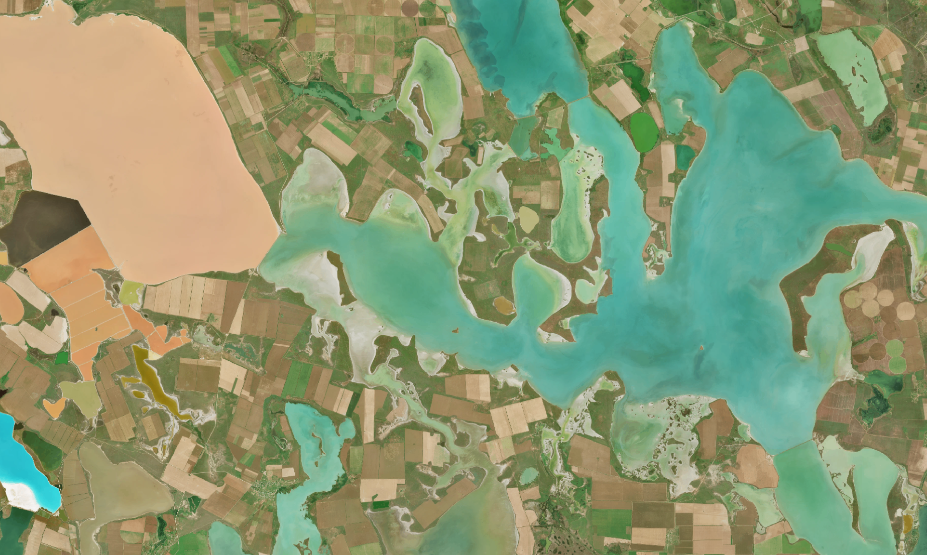
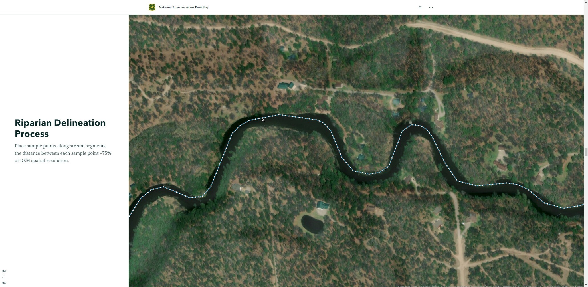
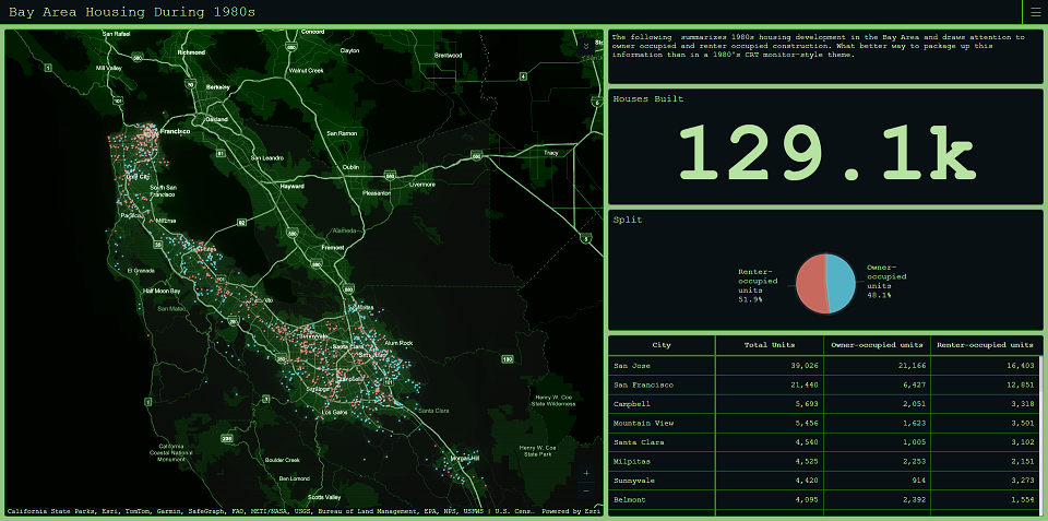
#BaseMaps

Stamen Designstamen@vis.social
2025-05-01

Over the years, Stamen has built and maintained tools of our own to supplement great tools created by larger carto community. Join us along a cartographic debugging journey as we explore how data, tiles, and stylesheets work together to make beautiful maps.

#maps #basemaps #design #cartography #opensource #maplibre #data #bts

stamen.com/debugging-101-with-

How open source tooling empowers our cartography debugging workflows..by allowing for map style comparison......and interactive data viz to see your map from a difference perspective.Learn more about how we upgraded how we debug on the blog.
Stamen Designstamen@vis.social
2025-03-06

Now on the blog: how we expanded UCSF’s Health Atlas from California (which we first collaborated on in 2019) to the entire US in 2024, including data and design updates across the entire tool.

Read now at stamen.com/taking-ucsfs-health

#maps #basemaps #design #cartography #ucsf #health #choropleth

How data viz and cartography combine to tell the story of health factors and outcomes......with beautiful yet simple choropleth maps......and interactive data viz to explain how variables interact.Learn more about how we upgraded the UCSF Health Atlas on the blog
Stamen Designstamen@vis.social
2025-02-13

On the blog: behind the scenes details on how we’ve migrated Columbia University’s Mapping Historical New York from raster to vector rendering. Read it now on the blog at stamen.com/vector-beeswarm-dot.

#maps #basemaps #design #cartography #columbia #historicalmaps #newyork

A map of New York overlaid with the text "How we did it: vector beeswarm dot density data visualization"A zoomed in screenshot of a spiral of colored dots with the text: "Learn more about the technical details on the blog now"
2024-08-07

An easy way to create a basic basemap, without GIS software, especially if you want to test orthographic projection oblique perspectives via @RhodesMaps #basemaps

mapspam.net/orthographic-map-c

2024-06-21

A large collection of high-quality basemaps, in various projections and of different territories, downloadable in SVG from the AB Pictoris library under CC BY-NC 4.0 #basemaps

abpictoris.com/fondsdecarte

2024-06-12

Graticule is a free and easy-to-use tool for creating basemaps by manipulating geographic projections while using graphic design concepts #basemaps

sciencespo.fr/cartographie/gra

2024-05-06

Germany's official basemaps are created from a centralized dataset, allowing for quick, cost-effective, and versatile cartographic products #basemaps

basemap.de/en/

2024-03-14

The #BaseNation book by #DavidVine is important and I forgot it a bit. Thertags on earlier posts let me find the on-line pages and maps from on this Fediverse account. At the Free Night School there are gatherings to see on-line maps and hear talks about foreign countries. A camouflage (hiding?) expert from the nearby Japanese military (Self Defense? 自衛隊) base does events too. Organizers asked me to join the camouflage events. It's interesting but I get qualms.
basenation.us/maps.html
#BaseMaps

A collage of four maps available from the page (or from the "Multimedia Maps" link) linked in the post. The four maps in the collage are 'Encircling "Enemies"', 'US Military Bases in East Asia', 'Protests and Evictions at U.S. Bases Abroad, 1950-202', and 'Okinawa, Japan'. The maps show that a number of US bases seem to contain, or circle Russia, China, and Iran and that many places all over he world would prefer not become militarized and are sometimes able to evict. There are several bases close to China's border,  and much of Okinawa's land is contained within US military bases.
Alan McConchiealan@subdued.social
2024-01-25

"basemaps are a tesseract"

Not sure if I posted this before, but posting it again so I can find it by searching for "tesseract".

#Tesseract #Hypercube #GalaxyBrain #basemap #basemaps #cartography #maps #MapDesign

A seven-panel version of the "galaxy brain" meme, with a map design client talking with a cartographer.

Client: “l need a basemap” Cartographer: “OK, here’s your basemap”

“We actually need a light mode and a dark mode (and maybe grayscale too).”  “Basemaps are a continuum!”

“We need a version of each basemap in English, but also in the local language” “Basemaps are a two-dimensional matrix!”

“Each basemap needs to support five different data providers” 
“Basemaps are a three-dimensional cube!”

“Each one also needs a separate transit mode, a pedestrian navigation mode, and a cycling mode”
“Basemaps are a tesseract!” 

“And we need a different version for CarPlay, and for wearables.” 
"Basemaps are a 5D hypercube!"

“And in the UK motorways should be blue, and...”
[cartographer achieves enlightenment]
Anita Graser 🇪🇺🇺🇦🇬🇪underdarkGIS@fosstodon.org
2023-12-02

Also new: #Satellite #basemaps by #Nimbo

It's simply fascinating to travel the globe and zoom into different regions of the world.

I compared to Google and ESRI satellite basemaps and think Nimbo's looks best

#gischat #qgis

nimbo.earth/products/earth-bas

satellite image of ukrainesatellite image of indonesia
💧🌏 Greg CocksGregCocks@techhub.social
2023-08-24

National Park Services (NPS) ‘Park Tiles’ [public web mapping, USA]
--
nps.gov/maps/tools/park-tiles/ <-- entry point
--
[also a mobile app ]
“Park Tiles is a suite of online basemaps designed to fit the National Park Service’s graphic identity. Built with simplicity and flexibility in mind, Park Tiles basemaps can be used as stand-alone reference maps, or customized web maps with additional data overlays. Park Tiles features NPS-sourced data inside park boundaries, and relies on OpenStreetMap data to provide additional context…”
#GIS #spatial #mapping #PostGIS #PostgresSQL #QGIS #vectortiles #opendata #opensource #gischat #ParkTiles #OSM #basemaps #NPS #maps #webmaps
@NPS

2023-04-04

Protomaps is transitioning from being 'open core', or partially proprietary, to an open source project with a tile generator and style generator for MapLibre GL #basemaps

github.com/protomaps/basemaps?

2023-03-14

I spent the 2nd half of 2022 working on these map styles and they finally launched! #cartography #basemaps
---
RT @stamen
New work: #AmazonLocationServices has launched four new map styles as part of their Open Data Maps service. Collaborating w/ AWS to make these maps has been a pairing of some of our favorite things: working w/ #OpenStreetMap & delivering custom map styles! stamen.com/open-data-maps-for-
twitter.com/stamen/status/1635

Luke Seelenbinder🇨🇭🇪🇪🇺🇸ls@hachyderm.io
2023-01-18

Off to London for @geomob tonight! I'm planning to act like an expert about #imagery #basemaps and tell all about how @stadiamaps is delivering a top tier imagery map at best-in-class pricing. Should be fun! 😄

I'm around til Friday, so give me a shout if you want to meetup.

A snowy Zürich airport.
2022-12-07

The Stamen basemaps, which have been online for free for over ten years and may disappear this 2023 due to lack of money, are well present in the #30DayMapChallenge #basemaps

stamen.com/30daymapchallenge-2

Client Info

Server: https://mastodon.social
Version: 2025.07
Repository: https://github.com/cyevgeniy/lmst