#Coldest

Knowledge Zonekzoneind@mstdn.social
2025-06-17

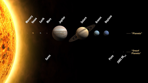
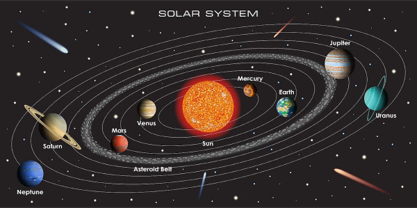
#KnowledgeByte: How much do you know about #Planets?

Did you know a day on #Venus is longer than its year. Specifically, a Venusian day (243 Earth days) is longer than a Venusian year (225 Earth days)?

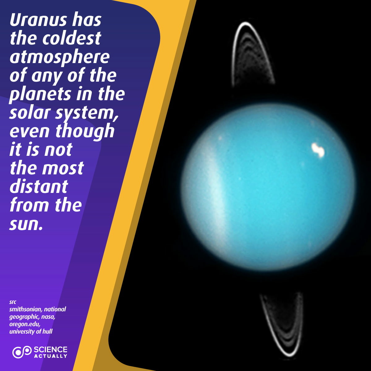
Facts about Planets. The #Hottest and #Coldest Planets and more...

knowledgezone.co.in/posts/How-

2025-03-29

Uranus has the coldest atmosphere of any of the planets in the solar system, even though it is not the most distant from the sun.

#science #sciencefacts #uranus #cold #coldest #gasgiant #icegiant

2025-02-12

ARCTIC COLD CONTINUES:

The #arctic #cold hovering over the #Northland continued Wednesday morning. The #coldest #temperatures was -40° in Celina.

Expect another very cold night tonight and Thursday morning, with #windchills likely back at dangerous levels.

#wxtooter #weather #wx #MNwx #WIwx #UPwx

Low temperatures across the Northland the morning of Wednesday, February 12, 2025, were all below zero.   Most locations were in the -15° to -35° Fahrenheit range.  The coldest reading was in Celina, Minnesota at -40°.Some of the coldest wind chill readings recorded in the Northland the morning of Wednesday, February 12, 2025, included 48-below at Cook, Minnesota, and Hibbing, Minnesota, 44-below at Birchdale, Minnesota, 41-below at Gowan, Minnesota, and 40-below at Grand Marais and International Falls, Minnesota.A Cold Weather Advisory is in effect from midnight through 10 a.m. on Thursday, February 13, 2025 for Aitkin, Bayfield, Burnett, Carlton, Cook, Douglas, Itasca, Koochiching, Lake, Pine, Sawyer, St. Louis, and Washburn counties.  Wind chill readings will drop as low as -35°, which could cause frostbite to form on exposed skin in as little as 10 minutes.
2025-01-19

IT'S BEEN COLD, IT WILL STAY COLD:

The #Northland is no exception to the nearly U.S. wide #arctic #cold snap. In fact, we will be one of, if not the, #coldest places when it it all said and done.

Looking back in the record books, and it has been nearly 6 years since we were this cold for high #temperatures.

It will remain this cold through Tuesday. Stay safe out there, everyone!

#wxtooter #weather #wx #MNwx #WIwx #UPwx

Low temperatures across the Northland for the morning of Sunday, January 19, 2025, ranged from 7-below to 31-below degrees.A number of locations recorded wind chill readings cold than 25-below during the morning of January 19, 2025.  The coldest was 53-below in Grand Marais.  Duluth, Hibbing, Fernberg, Isabella, and Silver Bay, all in Minnesota, saw wind chill readings reach 44-below or colder.An Extreme Cold Warning remains in effect for the entire Northland through at least 12 p.m. on Tuesday, January 21, 2025.  Wind chill readings could drop as low as 50-below.  That could lead to frostbite on exposed skin in as little as 10-minutes, and increase the risk for hypothermia and other cold-weather related illnesses and medical emergencies.For many locations in the Northland, the high temperatures we will likely see for January 19, 2025, are the lowest we have seen in nearly six years.  The range of 3-below to 15-below was last seen both during the month of February, 2021, and January 30, 2019.
2024-12-11

Happy #Wednesday afternoon from the #Northland!

It's the #coldest #temperatures the area has seen since last January.

They continue to drop below zero across the region, with #wind #chills as low as 35-below forecasted through tonight.

Bundle up if heading outside!

#wxtooter #weather #wx #MNwx #WIwx #UPwx

For the first time, a Cold Weather Advisory is in effect for most of the Northland through 10 a.m. on Thursday, December 12, 2024.  Wind chill readings are forecasted to drop between 20 to 35-below through this time period.Temperatures in the Northland just after 1 p.m. on Wednesday, December 11, 2024, range from 8 above to 9 below.  They have been cooling since this morning from west to east.With winds remaining breezy from the northwest, gusting at times over 30 mph, wind chill readings in the Northland just after 1 p.m. on December 11, 2024, range from 4-below to 32-below.A view from the camera from the roof of the FOX 21 studio building in Duluth around 1:30 p.m. on December 11, 2024, shows "sea/lake smoke" rising from the waters of Lake Superior as a ship makes it way towards the Duluth Canal.  The "smoke" is a type of fog that forms as water vapor evaporates from the lake, and is instantly changed to a cloud as it interacts with the much cooler air above.  Lake Superior water temperatures remain above freezing in the upper 30s and low 40s, with the air temperature hovering around 0°.
2024-11-26

Happy #Tuesday afternoon from the #Northland!

The area is dealing with the #coldest #temperatures we have seen since late March. Any #breeze is making it feel like single digits.

At least the #snow #showers have practically wrapped up for now.

#wxtooter #weather #wx #MNwx #WIwx #UPws

The satellite and radar over the Northland at 1:30 p.m. on Tuesday, November 26, 2024, shows cloud cover over the region.  Any snow showers or flurries are not being detected, with the best chances for them over Koochiching County and the South Shore Snowbelt region in the Upper Peninsula.Temperatures in the Northland just after 1 p.m. on November 26, 2024, range from 18 to 25 degrees.Wind speeds in the Northland just after 1 p.m. on November 26, 2024, range from calm to 17 mph.  Wind direction is primarily from the northwest and west.Feel like temperatures in the Northland just after 1 p.m. on November 26, 2024, range from 4 to 23 degrees.
2024-11-25

NORTHLAND FORECAST FOR NOVEMBER 26, 2024:

#Snow #showers will come to an end for most of the #Northland Monday night, but #lakeeffect bands will persist along the #UpperPeninsula.

The #coldest air of the season arrives, with low #temperatures in the teens and low 20s. A westerly #breeze will make it feel like single digits. Highs Tuesday will be in the 20s and low 30s as #winds slowly calm.

VIDEO: fox21online.com/2024/11/25/mon

#wxtooter #wx #weather #forecast #MNwx #WIwx #UPwx

Knowledge Zonekzoneind@mstdn.social
2024-06-17
2024-02-29

CHILLY WEDNESDAY NIGHT:

The #Northland will have one more night of #temperatures hovering around 0°.

The Arrowhead will be the #coldest, where it could feel as low as 30-below. Bundle up when out and about tonight and Thursday morning.

#wxtooter #weather #wx #MNwx #WIwx #UPwx

A Wind Chill Advisory is in effect for Cook, Lake, and northern and central St. Louis counties from 8 p.m. on Wednesday, February 28, 2024, to 8 a.m. on Thursday, February 29, 2024.  Wind chill readings could be as low as 30-below at times, causing frostbite to form on exposed skin in as little as 30 minutes.
2024-02-28

Happy #Wednesday afternoon from the #Northland!

After a somewhat #snowy, #windy, and #chilling Tuesday, we are enjoying the #sunshine, a decent #breeze, and the #coldest #temperatures we've seen in a few weeks.

#Spring-like #warmth returns starting Thursday.

#wxtooter #weather #wx #MNwx #WIwx #UPwx

The satellite and radar over the Northland at 2 p.m. on Wednesday, February 28, 2024.  It shows clear skies over nearly all locations in the region, with the only cloud cover positioned over the Upper Peninsula.Some of the highest snowfall totals observed in the Northland from February 27, 2024 include 6-inches in Indus, Minnesota, 5.4-inches in International Falls, Minnesota, 5.3-inches at Kabetogama, Minnesota, 4.8-inches in Gile, Wisconsin, and 4.7-inches in Mass City, Michigan.Temperatures in the Northland around 2 p.m. on February 28, 2024 range from 4 to 18 degrees.Wind speeds in the Northland around 2 p.m. on February 28, 2024 range from 8 to 18 mph.  Wind direction is from the west, northwest, and north.
2024-01-15

NORTHLAND FORECAST FOR JANUARY 15, 2024:

The #coldest of the #arctic air will take place Sunday night and Monday. #Lows will drop as low as -15°, with #highs around zero. A #Wind #Chill #Advisory is in effect for readings as cold as -40°.

Enjoy the mostly #cloudy skies, but #lake #effect #snow #showers will continue along parts of the #SouthShore due to #breezy west and northwest winds.

VIDEO: fox21online.com/2024/01/14/sun

#wxtooter #wx #weather #forecast #MNwx #WIwx #UPwx

2024-01-14

Happy #Sunday from the #Northland!

There are some peeks of #sunshine across the region, so maybe that is helping make the #coldest air we have seen in nearly a year a bit more bearable.

However, a #breeze isn't helping this out, making #wind #chills a top concern.

This will stay the case through the next week.

#wxtooter #weather #wx #MNwx #WIwx #UPwx

The satellite and radar over the Northland at 2 p.m. on Sunday, January 14, 2024 shows a few breaks in the low-level cloud cover across the region.Low temperatures in the Northland for the morning of Sunday, January 14, 2024 range from 3-below to 15-below.Temperatures in the Northland around 2 p.m. on Sunday, January 14, 2024 range from 6-below to 2-above.  The coldest temperatures are in the Iron Range and Rainy River Basin.Wind chill levels in the Northland around 2 p.m. on Sunday, January 14, 2024 range from 13-below to 25-below.
2024-01-03

When somewhere is too warm the consequence is that somewhere else is too cold.

«🇸🇪 #Sweden on Wednesday recorded its #coldest January night in 25 years, with a reading of minus 43.6°C in the far north as a cold snap hit the Nordics.»

france24.com/en/live-news/2024

2023-11-28

Happy #Tuesday from the #Northland!

After the #coldest #temperatures of the season last night, we are #warming back up closer to #seasonal this afternoon.

Meanwhile, some #snow #showers are moving into the region. Expect them to be #light and #scattered the rest of today.

#wxtooter #weather #wx #MNwx #WIwx #UPwx

The satellite and radar over the Northland at 1:25 p.m. on Tuesday, November 28, 2023.  It shows a mix of sun and clouds across the region, with light and scattered snow showers north of Highway 2.  They are moving from west to east.Low temperatures across the Northland the morning of Tuesday, November 28, 2023 ranged from 8-below to 5-above.Temperatures in the Northland just before 1:30 p.m. on Tuesday, November 28, 2023 range from 16 to 25 degrees.Wind speeds in the Northland just before 1:30 p.m. on Tuesday, November 28, 2023 range from 8 to 15 mph.  Wind direction is from the south and southwest.
2023-11-19

Happy #Sunday from the #Northland.

This past #weekend has been quite #sunny, as well as #warm for this time of the year. Not a bad one to enjoy the outdoors.

A change in the #weather pattern starts Monday. We will see #rain and #snow #showers at times, and the #coldest air of the season by #Thanksgiving.

#wxtooter #wx #MNwx #WIwx #UPwx

Temperatures in the Northland around 2 p.m. on Sunday, November 19, 2023 range from 37 degrees in Grand Marais to 52 degrees in Aitkin.  Most locations are in the 40s.Wind speeds in the Northland around 2 p.m. on Sunday, November 19, 2023 range from calm to 8 mph.  Wind directions are a mix across the region, with a bit of a lake breeze coming off Lake Superior.The satellite and radar over the Northland at 1:55 p.m. on Sunday, November 19, 2023 shows clear skies across the region.

Client Info

Server: https://mastodon.social
Version: 2025.04
Repository: https://github.com/cyevgeniy/lmst