#Geotagging

2025-05-29

Nope, sorry.

#DXO #PhotoLab8 kommt mir optisch zwar sehr entgegen und macht aus meinen RAWs sogar bessere Bilder als #Lightroom. Auch den Preis hätte ich bezahlt.

Aber die hohen Upgrade-Preise, fehlende hauseigene Goodies wie #HDR, Pano, Karten und #Geotagging bringen mich halt nicht weiter. Schade ums tolle Denoise und so, aber ich arbeite mich jetzt doch mal durch die etwas irre Lernkurve von @darktable . Bis Ende August brauche ich eine LR-Alternative…

2025-05-09

HoudahGeo 7 fait du géo-tagging sur les vidéos dlvr.it/TKg22t #HoudahGeo #GéoTagging

Terence Eden’s Blogblog@shkspr.mobi
2025-04-25

Reverse Geocoding is Hard

shkspr.mobi/blog/2025/04/rever

My wife and I run OpenBenches - a crowd-sourced database of nearly 40,000 memorial benches. Every bench is geo-tagged with a latitude and longitude. But how do you go from a string of digits to something human readable?

How do I turn -33.755780,150.603769 into "42 Wallaby Way, Sydney, Australia"?

Luckily, that's a (somewhat) solved problem. Services like OpenCage, StadiaMaps, OpenStreetMap, and Geocode.Earth all provide APIs which transform co-ordinates into addresses. Done! Let's go home.

Except… Not everywhere has an address. Some benches are in parks. They typically don't have a street number, but might have an interesting feature nearby to help with location. For example a statue or prominent landmark.

And… Not every address is relevant. Some benches are on streets. But we probably don't want to imply that the bench is inside or belongs to a specific nearby house.

Let's step back a bit. Why do we want to display a human-readable address?

We have two use-cases.

"As a visitor to the site, I want to:"

  1. Read a (rough) textual representation of where the bench is.
  2. Click on a component of the address to see all benches within that area.

The first is easy to explain:

The second is harder. Suppose a bench is in Wellington, New Zealand. We want to create a URl like openbenches.org/location/New Zealand/Wellington/. That way, users can click on the word "Wellington" and find all the benches nearby. A user can also manually edit that URl to increase or decrease precision.

Both of these are problems of precision.

Let's take a look at how one of the reverse geocoding services deals with transforming 51.476845,-0.295296 into an address:

Royal Botanic Gardens, Kew, Sandycombe Road, Kew, London Borough of Richmond upon Thames, London, Greater London, England, TW9 2EN, United Kingdom

That is too much address!

Yes, it is technically accurate. But it contains far too much detail for humans, the postcode is irrelevant, and the weird-subdivisions are nothing that a local person would use.

Looking at the full API response, we can see:

{  "place_id": 258770727,  "licence": "Data © OpenStreetMap contributors, ODbL 1.0. http://osm.org/copyright",  "name": "Royal Botanic Gardens, Kew",  "display_name": "Royal Botanic Gardens, Kew, Elizabeth Cottages, Kew, London Borough of Richmond upon Thames, London, Greater London, England, TW9 3NJ, United Kingdom",  "address": {    "leisure": "Royal Botanic Gardens, Kew",    "road": "Elizabeth Cottages",    "suburb": "Kew",    "city_district": "London Borough of Richmond upon Thames",    "ISO3166-2-lvl8": "GB-RIC",    "city": "London",    "state_district": "Greater London",    "state": "England",    "ISO3166-2-lvl4": "GB-ENG",    "postcode": "TW9 3NJ",    "country": "United Kingdom",    "country_code": "gb"  }}

Aha! Perhaps I can build a better address using just those components!

Except… Not every country has states. And not all states are used when giving addresses. Not every location is in a city. Some places have villages, prefectures, municipalities, and hamlets.

New York, New York is a valid address, but Berlin, Berlin is not!

There's an address formatter by OpenCage which is pretty sensible about stripping off irrelevant details. But, to go back to my first point, not every map location on OpenBenches is a street address and - even if it is on a street - it probably shouldn't have a house number.

Well, there's kind of a solution to that! Most mapping provider have a POI function - we can find nearby things of interest and use them as a location.

Here's a bench in Cook County, Illinois, USA. The POI address is:

{…   "name": "Central Park",   "coarse_location": "Des Plaines, IL, USA",…}

I assume there's only one Central Park in Des Plaines. Do people know that "Il" is Illinois? Would "Cook County" be useful?

On the subject of localisation, not everywhere speaks English. Do I want to display addresses like "原爆の子の像, 広島, 日本"? How about "原爆の子の像, Hiroshima, Japan"?

We're an international site, but most benches are in Anglophone countries.

Of course, just because something is physically near a POI, that doesn't mean it is logically close to it.

Consider a bench situated at the edge of this park

The nearest POI is "Gay's Creamery" - across the river. Is that what you'd expect? Is there any way to easily say "if a point is inside an amenity* then use that as the address?

I don't want the users of our site to have to select from a list of POIs or addresses, this should be as automated as possible.

The Plan

For each bench:

  1. Use StadiaMaps to get the nearest POI.
  2. Get the data in English.
  3. Concatenate the name and coarse location.
  4. Save the "address".
  5. Wait for complaints?

Thoughts?

#geolocation #geotagging #OpenBenches

Terence EdenEdent
2025-04-25

🆕 blog! “Reverse Geocoding is Hard”

My wife and I run OpenBenches - a crowd-sourced database of nearly 40,000 memorial benches. Every bench is geo-tagged with a latitude and longitude. But how do you go from a string of digits to something human readable?

How do I turn -33.755780,150.603769 into "42 Wallaby Way, Sydney, Australia"?

Luckily, that's a (somewhat) solved …

👀 Read more: shkspr.mobi/blog/2025/04/rever

Jan Helebrantjuhele@cztwitter.cz
2025-04-09

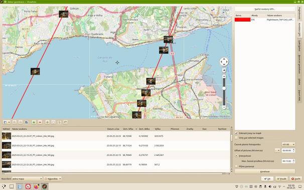
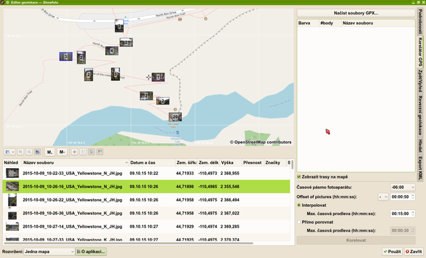
Chtěl jsem provést #geotagging fotek z letadla, ale z mobilu nebyl záznam z GPS - resp. nechytla se... Super ale je, že z #FlightAware se dá získat #KML, to jde snadno převést na #GPX a pak už to v #showFoto nechám přiřadit. Jen si člověk musí ohlídat časový posun u fotek...

2025-04-03

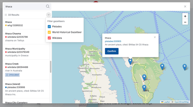
In other news: the #GeoTagging plugin for #RecogitoStudio has received a major overhaul:

• Various bugfixes.
• Improved Wikidata search.
• Search across multiple gazetteers.

Big thanks to the ATRIUM project for supporting this work! 🎉 atrium-research.eu/ github.com/recogito/geotagger

An example gazetteer search in the GeoTagging plugin for Recogito Studio.
2025-03-31

Search Engine Land: How geotagging photos affects Google Business Profile rank: Study. “How does adding coordinates to the EXIF data affect local rank? Our team wanted to find out. That’s why we recently conducted a 10-week study on the effects of geotagging for local rank.”

https://rbfirehose.com/2025/03/31/how-geotagging-photos-affects-google-business-profile-rank-study-search-engine-land/

𝕃𝔼𝔸ℝℂ𝕆 🪬 𓂀amaz3r.bsky.social@bsky.brid.gy
2025-03-28

@bsky.app Is #geotagging ever arriving on Bluesky? I really love to link pictures to the places I took them in…

David Schmidtindividual8
2025-02-05

The combination of photos and SVG maps of the actual locations makes this trail hike photo album truly compelling.

Koya Bound: Eight Days on the Kumano Kodo – walkkumano.com/koyabound/

2024-12-31

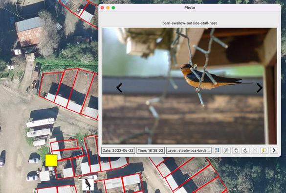
I've just finished geotagging my photos from November and December using #darktable. I use the "apply GPX track file" button with tracks from my Garmin GPS, or otherwise the Cyclemeter app on my iPhone, to accurately geolocate my photos. I get much better locations this way. My bigger cameras don't have internal GPS, but I also do this with all my iPhone and Nikon W300 photos. They can otherwise be off by 100 m or so. That difference matters for my nature observations.

#photography #geotagging

A screenshot from the darktable photo app, with a satellite underlay from Google Maps, showing three photos scattered about the sides of a building. All photos were taken in exactly the same place, but the on-device GPS varied in where it placed each photo.A screenshot from the darktable photo app, with a satellite underlay from Google Maps, showing a cluster of photos covering about 50 m radius. They were all taken at exactly the same location, but the on-camera GPS varied in where it put them.A screenshot from the darktable photo app, with a satellite underlay from Google Maps, showing the same buiding as before. The same three photos that were previously scattered about the building are now in exactly the same place, and several other photos from a camera without an internal GPS are also placed on the map. This was done by loading into darktable a GPS track from the Cyclemeter app on my iPhone.A screenshot from the darktable photo app, with a satellite underlay from Google Maps, showing all of the photos from the previous screenshot now geotagged in exactly the same location. Plus, it now reveals that the house to the north apparently has a business called "Bronzed and Foxy Tans".
2024-10-21

With #digikam you can correlate a #GPX track and a set of photos using their timestamps in order to #geotagging them.

The not so clear part is that if you want the images to store the #GPS coordinates in their metadata, you have to adjust the settings and say you want to store them there. Otherwise they are just stored on the program database and will not be exported.

Tech Cybersecurity Nieuwstech_cybersecurity_nieuws@mastodon.nl
2024-09-27

Threads introduceert locatie tagging: een nieuwe manier om jouw posts te personaliseren trendingtech.news/trending-new #Threads locatie tagging #sociale media platforms #Threads nieuwe functie #digitale aanwezigheid #geotagging in Threads #Trending #News #Nieuws

Tech Cybersecurity NieuwsTechNieuws@newsmast.social
2024-09-27

Threads introduceert locatie tagging: een nieuwe manier om jouw posts te personaliseren trendingtech.news/trending-new #Threads locatie tagging #sociale media platforms #Threads nieuwe functie #digitale aanwezigheid #geotagging in Threads #Trending #News #Nieuws

2024-08-05

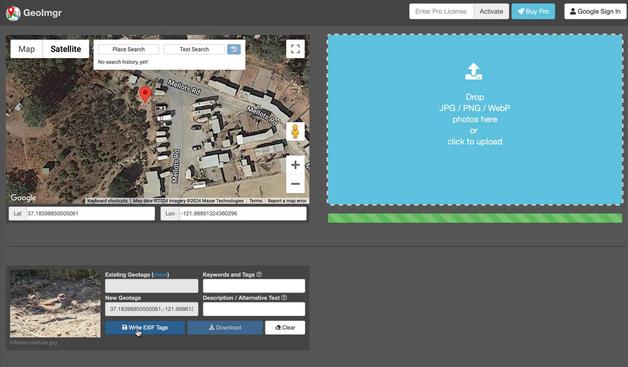
odkryłem, że nie włączyłem lokalizacji w aplikacji Google Camera (po prostu nie dałem uprawnień do lokalizacji).

W ten sposób zdjęcia, które robiłem w trakcie ostatniego wypadu Starym Kolejowym Szlakiem R15, nie miały żadnych lokalizacji. Dlatego mapy na Strava, w Google Photos czy w domowej PhotoPrism ↗ były pozbawione pinezek.

Ale z pomocą przyszło narzędzie exifTool ❤️

#linux #exiftool #geotagging

bobiko.blog/2024/08/fixing-mis

Tuomas Väisänen 📼🧟‍♂️waeiski@vis.social
2024-04-22

I wonder why #Twitter was so popular in #Turkey in 2012-2015 especially in terms of #geotagging posts?

We're working on extracting different types of regional #mobility from the data, and Turkey is over-represented in the data. The amount is approximately 2–3 times the content from Italy, France, and Spain combined.

JL Johnson :veri_mast:User47@vmst.io
2023-12-24

I am looking for a lightweight -preferably #opensource- PC tool for mass #geotagging photos, maybe other exif updates. I don't use light room anymore.

My notes show I used to really be into Microsoft Pro Photo Tools. But that hasn't been updated in 15 years. v2 was released in 2008. HA!

#photography #help

NeoFinder for macOS and iOSneofinder
2023-12-01
Jan Helebrantjuhele@cztwitter.cz
2023-11-29

#Showfoto je vážně super app na #geotagging fotek. Stačí #GPX soubor z mobilu a dá se přiřadit poloha bez ohledu na to, jaký má člověk foťák...

Client Info

Server: https://mastodon.social
Version: 2025.04
Repository: https://github.com/cyevgeniy/lmst