#PopulationDensity

A Guy Named Brian (he/him)GuyNamedBrian
2024-12-01

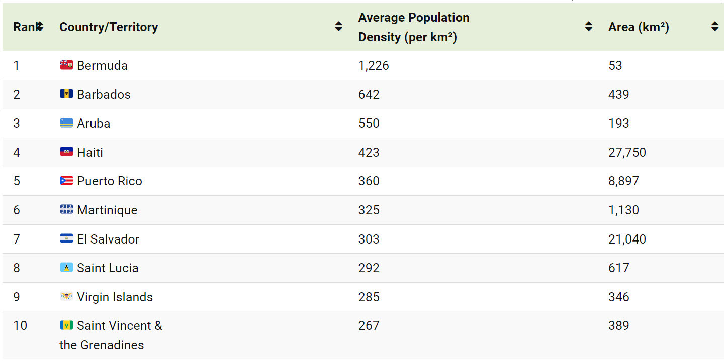
“Food deserts are not an inevitable consequence of poverty or low population density, and they didn’t materialize around the country for no reason. Something happened. That something was a specific federal policy change in the 1980s. ... Food deserts will not go away until that mistake is reversed.”

theatlantic.com/ideas/archive/

2024-11-04

The original map was printed in Black and White and hand coloured using colouring pencils on hand. The purple originally didn't differentiate enough with the lighter pink so heavier pressure was applied.

#SpatialThinkLab #SpatialThinking #Wellington #PopulationDensity #maps #Aotearoa #30DayMapChallenge2024

American NaturalistASNAmNat@ecoevo.social
2024-05-30

Read now ahead of print! "Dynamic Trait Distribution as a Source for Shifts in Interaction Strength and Population Density" by Jackson & Xue journals.uchicago.edu/doi/10.1

#traitDistribution #interaction #populationDensity

@james I could see that happening, but maybe it will result in small cities of 50k people at higher #PopulationDensity, surrounded by farmland, rather than a low-density sprawl/spread.
webseitz.fluxent.com/wiki/Opti
webseitz.fluxent.com/wiki/Popu

Ryan Hitereligiousryan
2023-09-07

🌍 Did You Know? Over 95% of Egypt's population lives along the Nile, despite most of its land being desert! Dive deep into this unique geographical phenomenon. You'll never see Egypt the same way again! 🎥🌟

2023-01-28

Indiana is the 16th most densely populated state in the USA, but this region in the hills of south-central has about the same population density as much of West Virginia. It’s very rare that I see anyone else in the state forests of eastern Monroe or western Brown Counties when I’m out hiking. #Indiana #PopulationDensity

Map of population density in IndianaMap of population density in West Virginia
Jordi Fustépepitolomo
2023-01-10

PARA PENSAR 🤔
Mapas 3D que muestran la diferencia en la densidad de población de cada país. El estudio de la densidad de población puede determinar cómo viven las personas que están en el territorio. Visualised by @terence in rstats with rayshader @tylermorganwall

Global Population Density

#maps #populationdensity

2022-12-08

One often hears that places like Montgomery County are ‘crowded’ and ‘overpopulated.’

People are missing the forest for the trees. These places aren’t crowded because of the amount of people. It’s because of the fucking CARS. It’s always the cars. Take the cars away and everything will feel empty. #transportation #Transpodon #populationdensity

Cees Grootesanalyticus
2022-11-29

A 3D Look at the Largest Population Density Centers.

It can be difficult to comprehend the true sizes of megacities, or the global spread of 8 billion people, but this series of population density maps makes the picture abundantly clear.
Created using the EU’s population density data and mapping tool Aerialod by Alasdair Rae, the 3D-rendered maps highlight demographic trends and geographic constraints.

visualcapitalist.com/cp/3d-map

Global Population Density
Dick Smiths Fair Go Supportersdsfgs@activism.openworlds.info
2020-05-20

@patricksudlow
The page blocks Tor.

Isn't #Russia fast 'catching up to' or now surpassed the UK in terms of cases? At RT they said the rate in Russia was very high at 8000 new infections in a day.

Of course, 'new cases' does not equal deaths, but if deaths due escalate maybe Russia will need to reconsider her attitude towards extreme #populationDensity and #gentrification also.

Dick Smiths Fair Go Supportersdsfgs@activism.openworlds.info
2020-05-07

Client Info

Server: https://mastodon.social
Version: 2025.04
Repository: https://github.com/cyevgeniy/lmst