
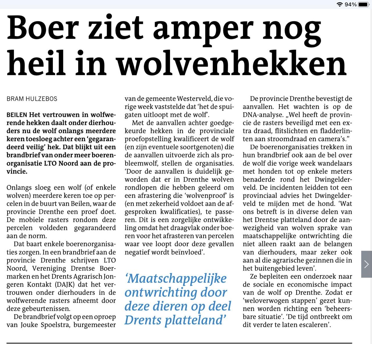
Wanneer gaan journalisten en boeren begrijpen dat als wolven een “gegarandeerd aan de normen voldoend” “wolvenproof” raster of hekken kunnen passeren de normen het probleem zijn en niet de wolven?
#Wolvenproof
#Wolfwerend
#Rasters
#Hekken
#Normen
#LTO
#Rasters

𝗗𝗿𝗲𝗻𝘁𝘀𝗲 𝘀𝘁𝗮𝘁𝗲𝗻 𝗸𝗲𝗿𝗲𝗻 3,3 𝗺𝗶𝗹𝗷𝗼𝗲𝗻 𝗲𝘂𝗿𝗼 𝘂𝗶𝘁 𝘃𝗼𝗼𝗿 𝘄𝗼𝗹𝗳𝘄𝗲𝗿𝗲𝗻𝗱𝗲 𝗿𝗮𝘀𝘁𝗲𝗿𝘀
De meer dan vierhonderd subsidieaanvragen van veehouders in Drenthe voor wolfwerende rasters kunnen worden toegekend. Partijen in Provinciale Staten zijn ermee akkoord gegaan dat hiervoor 3,3 miljoen euro wordt gebruikt, waarvoor de provincie nog geen bestemming had. "Voor nu is dit de...
Het kan dus wel degelijk!
#wolven #rasters #vee
Drenthe positief over proef met mobiele rasters als bescherming tegen wolven | Goed nieuws | NU.nl https://share.google/CqiRHd9CbN8oQE0FT

Landscape Metrics - “R As GIS” Course
--
https://jakubnowosad.com/rgis2025/output/landscape_metrics.html#/title-slide <-- shared presentation
--
#GIS #spatial #mapping #R #tutorial #onlinelearning #presentation #rasters #remotesensing #earthobservation #landscape #metrics #spatialanalysis #spatiotemporal #natural #social #cultural #ecosystems #biodiversity #water #waterquality #usecase #geomorphology #geomorphometry #patterns


Chatter on ImageNet and Geoffrey Hinton (back propagation for deep learning). I think ImageNet *is* awesome and having a vast classified open image archive is what made Hinton's work possible. Anyone know of a #geospatial equivalent out there?
... “Pre-ImageNet, people did not believe in data,” Li said in an interview... “Everyone was working on completely different paradigms in AI with a tiny bit of data”...

The development version of the #rstats terra package now uses the viridis color palette by default.
Read about it at https://buff.ly/3wtvQi7.

Howdy #mapstodon !
I'm hoping someone can take the time to help a #GIS #noob with a project. I'm working in the #Unity3D game engine to create game terrain from real world data.
So far it has been successful, but it is a painstaking process done completely by hand.
My trouble has to do with the projection of #OpenTopography data, USGS30m #Rasters to be precise.
I've attached two images to illustrate my problem...


#Rasters In A #Database? with @pwramsey
That's a definite must-listen episode from the always fabulous @MapScaping #podcast

Can you pronounce QGIS 3.30's version name?
QGIS 3.30 's-Hertogenbosch is currently in packaging. It's already available for Linux users from the QGIS repositories while Windows and Mac installers should be available soon.
You can read the changelog at: https://changelog.qgis.org/en/qgis/version/3.30/ or watch at https://www.youtube.com/watch?v=q7O819lFKc4
What are you most excited about in QGIS 3.30?

Client Info
Server: https://mastodon.social
Version: 2025.07
Repository: https://github.com/cyevgeniy/lmst