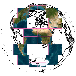
#STAC

EvoLandEvoLandEU
2025-12-16

🌍 EvoLand's new Catalogue offers an open, FAIR gateway to datasets making planetary data more accessible than ever. It’s like a library card catalog for the planet – making it easier to track how our landscapes are changing.

🌱 From Gross Primary Productivity (GPP) data to other key metrics, researchers and policymakers can now explore, query, and reuse data with ease.

🔗 Read more: evo-land.eu/evolands-new-stac-

@EU_HaDEA @EU_ENV @DLR @cnes

2025-12-11

Swiss government open-source catalog: Under Article 9 of the “Federal Act on the Use of Electronic Means to Carry Out Official Tasks” (#EMBAG / #LMETA), federal authorities must publish the source code of software they develop or commission, marking a step toward greater #digitalSovereignty. The #OSS Catalog lists around 60 #opensource projects with #swisstopo’s #STAC API and the mapping application #KADASAlbireo among them.
spatialists.ch/posts/2025/12/1 #GIS #GISchat #geospatial #SwissGIS

💧🌏 Greg CocksGregCocks@techhub.social
2025-11-07

OGC Announces Publication of the SpatioTemporal Asset Catalog Community Standards

--
ogc.org/announcement/ogc-annou <-- shared technical announcement
--
"The SpatioTemporal Asset Catalog (STAC) specification provides a common structure for describing and cataloging spatiotemporal assets..."
#GIS #spatial #mapping #opensource #OGC #Geospatial #GeospatialAPI #Interoperability #Metadata, #OGCStandards #standards #SpatioTemporal #AssetCatalog #STAC #community
@OGC

2025-10-30

STACD: STAC and DAGs: #STACD, a new extension for SpatioTemporal Asset Catalogs (#STAC) from @spatialnodehq leverages #DAG-s to track data lineage, version algorithms, and efficiently re-compute only affected downstream STAC assets when an upstream asset is updated.
spatialists.ch/posts/2025/10/3 #GIS #GISchat #geospatial #SwissGIS

2025-10-28

Publication of the SpatioTemporal Asset Catalog Community Standards: The Open Geospatial Consortium (#OGC) has officially published the SpatioTemporal Asset Catalog (#STAC) Community Standards, marking a key milestone in data #interoperability. Built for flexibility and scalability, STAC provides a standardized...
spatialists.ch/posts/2025/10/2 #GIS #GISchat #geospatial #SwissGIS

MapServer projectmapserver@fosstodon.org
2025-10-21

🚀 New tutorial!
Learn how to render #STAC data directly with #MapServer + #OpenLayers!
👉 mapserver.github.io/getting-st

Image showing LCMAP primary land cover classification from a STAC server, rendered directly using MapServer
Olivier D'Hondt 🛰️🌍🌱tyldurd@framapiaf.org
2025-10-01

🛰️ I’m currently experimenting with combining the Copernicus STAC and S3 APIs to make the EO-Tools Sentinel-1 processing chain leaner and more efficient.
The idea is to avoid downloading full products when only a subset of bursts is needed.

I know the total monthly bandwidth allowance, but does anyone know if there’s a way to check how much bandwidth remains after using the API?

#Sentinel1 #SAR #STAC #Copernicus #EarthObservation #RemoteSensing #InSAR #OpenSource #EOTools

Michael Sumnermdsumner@rstats.me
2025-06-26

here's my take on defining a "geobox" at a longlat point, where I only need a longitude, latitude, distance, and n-pixels

gist.github.com/mdsumner/2af15

I use a local projection to ease the geographic extent definition, then transform that to (auto) UTM, then get the longlat bbox (for STAC query), and the UTM GeoBox (for odc to render to)

#Python #odc #stac #opendatacube

2025-06-14

Another blog post with links to interesting things I've found semi-recently: blog.rtwilson.com/more-links-j

I promise there will be some more interesting blog posts coming up soon, but hopefully this will be useful to someone. Includes links around #python #geospatial #stac #3dprinting and more.

:rss: Qiita - 人気の記事qiita@rss-mstdn.studiofreesia.com
2025-06-04

自然言語で宇宙探索!衛星データ検索基盤のSTAC API用のローカルMCPサーバー作ってみた!
qiita.com/nokonoko_1203/items/

#qiita #TypeScript #MCP #STAC #LLM #Claude

So it seems from the lack of responses to my previous post fediscience.org/@jgomezdans/11 that no one is using the #Copernicus #DataSpace via #STAC. I guess most academic #geo peeps use #GoogleEarthEngine or just download the data files directly? Is STAC only really used by commercial #satellite "bros"?

2025-04-03

I've just released #eoAPI-k8s version 0.6.0 github.com/developmentseed/eoa

#eoAPI is a scalable geodata infrastructure based on #STAC and ready for the cloud. Its components power data distribution for Microsoft's Planetary Computer, NASA, ESA and Planet and others. eoapi.dev/

The new version:
* upgraded all components to the latest versions
* includes initial support for multidim data
* and some improvements in the startup to reduce error messages

#FreeSoftware by @developmentseed

2025-04-02

#stac and #ogc together at the #stapi sprint in Lisbon! :) #standards #foss #foss4g

2025-04-01

First day of the #stapi sprint at #developmentseed was fueled by lots of interesting discussions on issues like intersections with #stac and #ogcapi . Looking forward to more, tomorrow! ❤️ #standards #geospatial #eo

2025-02-25

geodienste.ch: STAC API and OGC API Features: With its newest release, #KGK/#CGC offers an OGC #STAC API as well as #OGC API Features for data on geodienste.ch, in accordance with #eCH-0056. Assets seem limited to XTF files, though.
spatialists.ch/posts/2025/02-2 #GIS #GISchat #geospatial #SwissGIS

Anita Graser 🇪🇺🇺🇦🇬🇪underdarkGIS@fosstodon.org
2025-02-06

What's your favorite minimal geospatial (meta)data management stack right now?

Guess a classic would be #PostGIS and #QGIS PgMetadata plugin

Cloud-native / flat file-only equivalents? #STAC all the way?

#GISChat

Anita Graser 🇪🇺🇺🇦🇬🇪underdarkGIS@fosstodon.org
2025-02-01

Recently, someone mentioned #STAC as a general purpose geodata catalog (not just for imagery but also vector). Is that a thing? And even if it is possible, is it a good idea?

#GISChat #OSGEO #OGC

2025-01-28

As the OGC API - Records Candidate Standard enters the voting period, you can learn more about this flexible specification at: records.developer.ogc.org/ #OGCAPI #standards #catalog #metadata #discoverability #stac

das-g @ 39C3 (DECT 7881)das_g@chaos.social
2024-11-13

@hareldan I'm not sure #STAC (SpatioTemporal Asset Catalogs; stacspec.org) support for OSM editors would be worth the effort: Is there enough STAC-indexed imagery (or other STAC-indexed data) useful for mapping that is licensed such that using it for OSM mapping (and re-licensing the result under #ODbL with just "central" attribution on the OSM wiki rather than attribution embedded in the thusly created or modified parts of the OSM data and any derived DBs & works) is allowed?

Client Info

Server: https://mastodon.social
Version: 2025.07
Repository: https://github.com/cyevgeniy/lmst