#TerrainAnalysis

2025-11-26

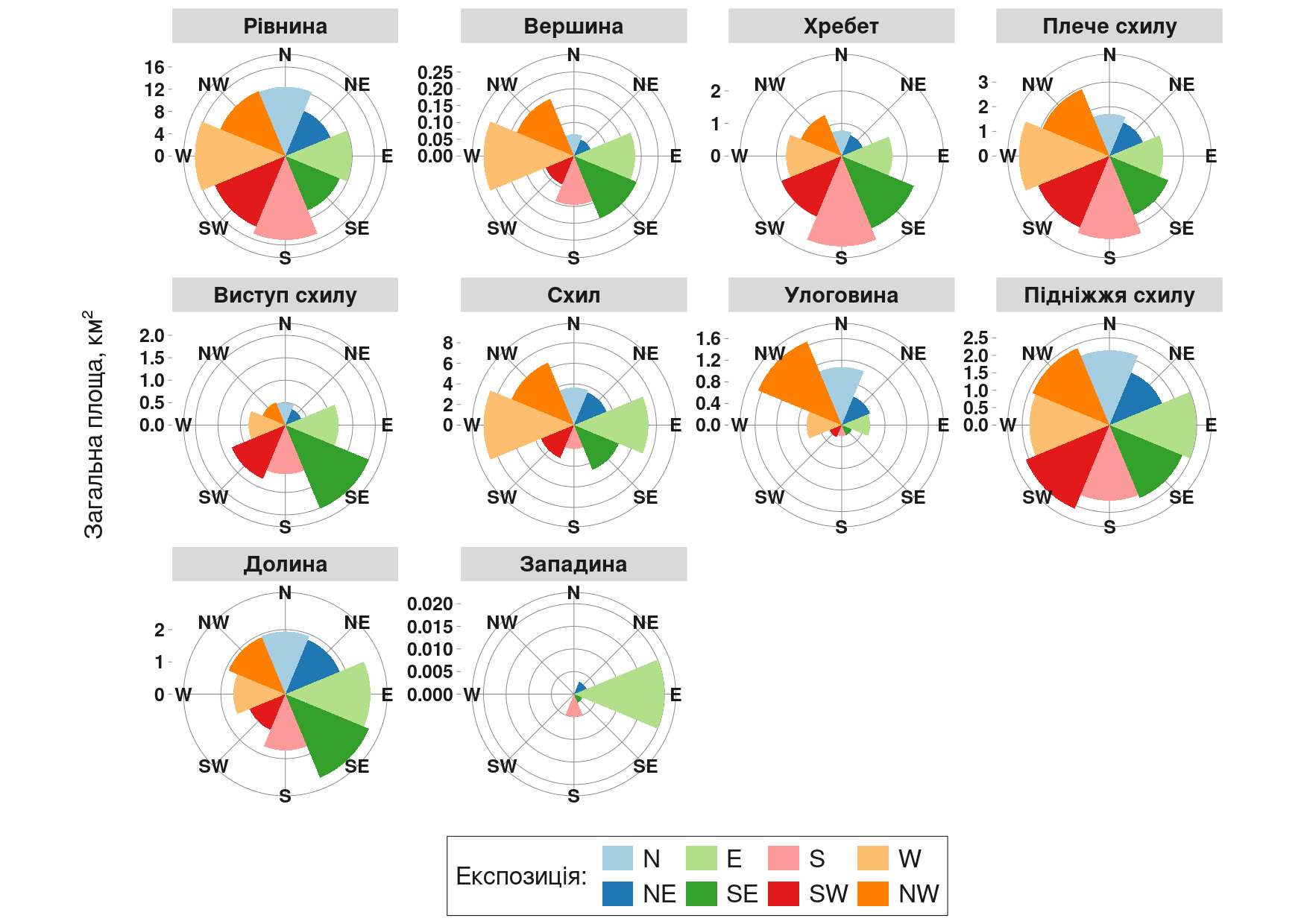
There are many ways to represent the spatial anisotropy of terrain forms.
In this case, I focused on a comparative approach: the real surface area of different geomorphon classes plotted against slope aspect.

All calculations were performed within the polygon of the effective catchment area of the Inhulets River.
This visualization highlights how specific landform types tend to โ€œalignโ€ with certain aspect directions, revealing structural asymmetries within the catchment.

#Geospatial #Geomorphometry #TerrainAnalysis #RStats #DataViz #Hydrology #SAGA #EnvironmentalScience #GIS #RemoteSensing #InhuletsRiver #ggplot2 #Copernicus #CopernicusDEM #Geomorphology

Polar plots of surface area by geomorphon type and slope aspect. Each panel shows the real surface area (kmยฒ) of a particular geomorphon class distributed across eight aspect categories (N, NE, E, SE, S, SW, W, NW). Calculations performed within the effective catchment polygon of the Inhulets River.
2025-11-16

โœจNovel data, methods and applications in Geomorphometry: ๐—ฐ๐—ฎ๐—น๐—น ๐—ณ๐—ผ๐—ฟ ๐—ฎ๐—ฏ๐˜€๐˜๐—ฟ๐—ฎ๐—ฐ๐˜๐˜€ for the 23rd annual meeting of the Asia Oceania Geosciences Society in Japan!

Session listed as IG38: Interdisciplinary Geosciences, and it is organized by Massimiliano Alvioli, Takashi Oguchi, Mio Kasai, Cheng-Zhi Qin, and Li-Yang Xiong

๐—ฆ๐—ฒ๐˜€๐˜€๐—ถ๐—ผ๐—ป ๐—ฑ๐—ฒ๐˜€๐—ฐ๐—ฟ๐—ถ๐—ฝ๐˜๐—ถ๐—ผ๐—ป: lnkd.in/d9KcjVJV

The ๐—ฑ๐—ฒ๐—ฎ๐—ฑ๐—น๐—ถ๐—ป๐—ฒ for submission and request for ๐—ณ๐˜‚๐—ป๐—ฑ๐—ถ๐—ป๐—ด ๐˜€๐˜‚๐—ฝ๐—ฝ๐—ผ๐—ฟ๐˜ is January 23, 2026

#DEM #terrainanalysis #spatialanalysis #geoinformatics

2025-07-30

New R package: rgeomorphon ๐Ÿ“ฆ by Andrew Brown

Classifies terrain forms using a parallel C++ implementation of the geomorphon algorithm.

๐Ÿ”— github.com/brownag/rgeomorphon

#RStats #GIS #TerrainAnalysis #RemoteSensing #RSpatial

Client Info

Server: https://mastodon.social
Version: 2025.07
Repository: https://github.com/cyevgeniy/lmst