#topography

Archways to better planning: Lessons from Moab, Utah

Listed below are a number of planning lessons identified from glorious Moab, Utah. While reading these, some may sound rather critical. Pointing out flaws is not the intent. Like most people who visit Moab, they fall in love with the ruggedly stunning red rock landscape, as well as the charming town. Unfortunately, Americans have a tendency to overwhelm places they adore by literally “loving them to death.”

Moab, Utah – Source: lonelyplanet.com

The Moab of 2025 is quite different than the Moab of 2003 when I last visited there. Personally, I miss many aspects of more innocent Moab. While there have definitely been some improvements, there are also a lot of concerns and challenges facing the city/area not the least of which is mass tourism.

The lessons listed below are similar to many of the conundrums facing tourist towns. We saw them first hand while living in Traverse City, Michigan. The big question is how to most effectively address them. Answers are not always easy, so it is likely to take an incremental approach. Researching and employing existing successful tactics learned by other tourist towns is a great approach — why reinvent the wheel when there are proven options already!

“Moab magic is made of Quiet Yeses and Small Wins over time…
If we could wave a magic wand and create the perfect world, we would. But reality is complicated. We know a healthy community is a ‘forever project’ maintained by passionate people doing what they can, when they can.”

Source: moab-solutions.org

Hopefully these will provide some useful insights and ideas. That being said, new ideas should never be dismissed. When tackling difficult and complex planning issues, there is no such thing as a bad idea. Furthermore, all stakeholders should have a seat at the table.

Here’s wishing Moab all the very best in its ongoing efforts to address the variety of community challenges facing it. Peace!

——-

Satellite image of Moab and nearby areas – Source: visibleearth.nasa.gov
  • The Moab area may have more varied topographical, geological, and natural wonders per square mile than any other place in the United States. Protecting these unique and beautiful features at all cost should always be priority number one. That includes protecting them from poor decisions coming out of Washington, D.C. and/or Salt Lake City.
  • At some point, there are only so many ecotours, rafting providers, and off-road adventures that can be accommodated before they begin to overwhelm a host community like Moab and harm the natural ecosystems that drew everyone there in the first place. At what point is enough ENOUGH?
  • It is distressing to see hotel sprawl inch ever closer to Arches National Park. Some form of growth boundary is needed to maintain the visual and aesthetic integrity of natural areas surrounding the park, particularly between it and the city. At a minimum, zoning around the park should limit the uses that permitted to those which a conducive and complementary to the park itself. This should NOT include commercial, extractive, or industrial uses.
  • For a town of 5,336 residents, Moab contains 3,070 hotel, resort, and B & B rooms at the current time (June 2025). According to information cited from April 2024 by Google Gemini, another approximate 700 lodging rooms are in the pipeline. These numbers do not begin to include commercial and public campsites, camping cabins, tiny house rentals, and guest houses/condos. Furthermore, according to AirDNA, Moab has 1,737 Airbnb and VRBO properties available. Needless today, during peak seasons, tourists far outnumber the local residents.

Based on the previous three points, Moab must continuously fight like hell to guard against the evils of mass tourism to keep it from overwhelming the community.

Traffic backed up onto U.S. 191 at the entry to Arches National Park – Source; everywherewithclaire.com
  • Housing for locals and seasonal employees is increasingly expensive due to the popularity of living in a scenic resort community and as more residential properties become “pseudo-hotels.” According to Rocket.com, the median list price in Moab/Grand County Utah in May 2025 was $664,000. Not exactly attainable nor affordable for most tourism/service industry employees.

“Moab and Grand County, like many other places across the country, have struggled with housing scarcity for years. The issue is exacerbated in Moab and other resort towns, where tourism drives up property values, and many jobs essential to the local economy are relatively low-paying service industry positions.”

Source: utahstories.com

The Moab Area Housing Task Force was established by the city, surrounding Grand County, and Housing Authority of Southeastern Utah. They are working to address housing issues with efforts like a Housing Choice Voucher Program, subsidized apartments and homes, a Mutual Self Help Program, the CROWN Rent-to-Own Program, as well as a senior living facility. Meanwhile, Moab Solutions is addressing the city’s houseless population through street level outreach and an emergency needs fund. Last but not least, since 2010 Community Rebuilds has been constructing affordable single-family homes in the Moab and Spanish Valleys.

Source: hasuhomes.org Source: moab-solutions.org Source: community rebuilds.org
  • Moab could use a truck route to direct semis and other big rigs away from downtown. U.S. 191 is a major route that serves as the northern part of the corridor connecting Salt Lake City and Albuquerque. The noise, pollution, and added traffic harms the aesthetics and appeal of the city’s core.
Local sign promoting quiet streets in Moab

There are those in Moab trying to correct this issue, as well as noise coming from off-highway (OHV) and all-terrain (ATV) vehicles driving around town. Due to the narrow valley where Moab sits (see the geological map earlier in this post), practical options for an alternative truck route are limited. Regarding OHVs and ATVs, Utah bars counties from restricting OHV businesses. Furthermore, Moab itself has been challenged over the city’s noise regulations. A recent challenge was dismissed in November 2024.

OHV on U.S. 191 in Moab
  • The historic tradition of Utah cities and towns to have uber-wide primary streets (first established by Brigham Young in Salt Lake City) can be detrimental to the community being pedestrian friendly. Traffic calming and road diets are likely the best options to address this topic.
  • In a state with five incredible national parks (Arches, Bryce Canyon, Canyonlands, Capitol Reef, and Zion), producing megatons of tourism dollars, it is frustrating to hear Utah politicians pissing and moaning about the size of newer national monuments like Bears Ear and Grand Staircase Escalante.  At some point, states like Utah need to learn that mineral dollars are fleeting, while tourism dollars are permanent. That being said, as noted above, there are definitely issues to contend with when a tourist destination becomes overwhelmingly popular.
Source: energy.gov

Despite the difficulties arising from mass tourism, the UMTRA Project on the north side of Moab exemplifies the enormous long-term legacy costs associated with an over reliance on extractive industries. Technically called the Moab Uranium Mill Tailings Remedial Action (UMTRA), the project is removing 16 million tons of uranium tailings from 130 acres adjacent to the Colorado River. As of mid April 2025, more than 97 percent of these tailings have been successfully removed to a new permanent location. Most recent estimates from the Department of Energy indicate the total cost of this cleanup will exceed $720 million. What isn’t known, are the health, environmental, and similar costs that have accumulated since a uranium was first milled on the site in 1956.

  • Moab has incorporated delightful and eccentric artwork (see photos below), unique benches, murals, and landscaped pockets in and near its main intersection in downtown. Hopefully, Moab can extend these tactical efforts throughout the city. They are great placemaking steps that appeal to locals and visitors alike.
  • Even though Arches National Park has a reservation system to limit crowds during peak periods, it only applies between 7 a.m. and 4 p.m. As the park is open 24/7, one can enjoy the majesty of Arches without dealing with the reservation process, the crowds, and also the hottest part of the day. Given the grueling temperatures in Moab during certain parts of the year, before and after hours options can make the spectacular even more enjoyable. Oh, and the angles from shadows and sunlight in the morning or evening can also create more vivid images of this geological masterpiece.
Source: shakaguide.com

#arches #ArchesNationalPark #cities #environment #fun #geography #geogtaphy #geology #history #landUse #Moab #NationalParks #planning #terrain #topography #tourism #transportation #travel #Utah

💧🌏 Greg CocksGregCocks@techhub.social
2025-06-10

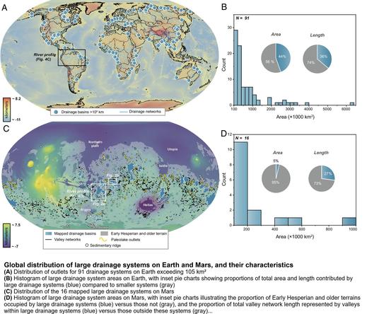
Bidirectional Translations Between Observational And Topography-Based Hydrographic Data Sets - MERIT-Basins And The SWOT River Database (SWORD)
--
doi.org/10.1029/2024WR038633 <-- shared paper
--
#GIS #spatial #mapping #water #hydrology #model #modeling #SurfaceWater #Ocean #Topography #SWOT #SWORD #hydrography #stream #river #datasets #MERIT #basin #watershed #inventory #routing #network #discharge #flow #peakflow #remotesensing #satellite #earthobservation

America’s newest high-altitude thru-hike: Santa Fe to Taos

Presentation at Travel Bug in Santa Fe

Its not often you have the opportunity to enjoy something completely new in the world of hiking and high-altitude adventure, but that is just the case now in New Mexico. On Saturday evening (May 31) we attended a presentation and guidebook signing at Travel Bug Books for America’s newest high altitude trek: The Santa Fe to Taos Thru-Hike.

Nambe Lake: Source: reddit.com

This 132 mile long trek takes you from Santa Fe Plaza in the heart of this lovely capital city, high up in the Sangre de Cristo Mountains to well over 11,000 feet, and eventually back down to the gorgeous city of Taos and its historic plaza.

Source: santafetotaos.org

Conceived, organized, trekked, and established over a ten-year period by avid hiker Pam Neely, this thru-hike will take you through some of the most stunning scenery in New Mexico. This includes: Santa Fe Ski Basin, Trailriders Wall, the Pecos Wilderness, Santa Barbara Divide, El Nogal, two national forests, and numerous streams and alpine lakes including Baldy and Nambe (see photos).

Trailriders Wall – Source: summitpost.org

The new pocket-sized guidebook is an excellent resource for those planing to hike straight through or planning to tackle the trek in pieces and parts. She also a series of six 11″ x 17″ maps available depicting segments of the route landing from 18.7 to 26.2 miles in length. The guidebook and maps identify key points along the trail, other connecting trails, suggested camping places, points of access to water sources, and a variety of other useful information.

Pecos Baldy Lake – Source: reddit.com

Here are some non-amazon places to order the guidebook:

One may start at 7,000 feet at either end of this thru-hike, but in-between are a series of climbs and descents that truly define this storied and enchanted landscape. Whether you hike the entire 132 mile length or simply small day-hike segments, the Santa Fe to Taos Thru-Hike will stir your senses to the rugged and serene beauty of New Mexico. Peace!

Santa Barbara Divide – Source: pinterest.com

#books #environment #fun #geography #hiking #history #NewMexico #SangreDeCrstoMountains #SantaFe #Taos #thruHikes #topography #TrailridersWall #travel #treks

Kevin Bowen (has moved) :xfce:kevinbowen@fosstodon.org
2025-05-17

Where is Seattle's datum point -- "the point at which all other elevations in the city will be based"?

historylink.org/File/10306

#Seattle #History #Topography #Surveying

Planning for cities with linear skylines

Shown below are some of the cities around the globe that have linear skylines. While these can be visually impressive, especially when set as a backdrop against the coastline or mountains, they also can be challenging from a planning and infrastructure perspective, unless they are adapted properly to address this unique urban landform.

World’s narrowest city of Yanjing, China – Source: amapnerd.com

Bear in mind, that linear skylines are not just a coastal or narrow valley phenomenon. Las Vegas is perfect example of an inland city with a very linear skyline that resulted in part due to how the city developed as a desert oasis along a single major corridor. Other examples may result from topographic settings like narrow mountain valleys, river valleys, peninsulas, or islands.

The length of linear skylines can tend to dissuade walking, as the distances between sites can be intimidating. Furthermore, if the focus is too concentrated, primary streets that run the length of the skyline, such as the Las Vegas Strip, can become overwhelmed by traffic and people.

Traffic and people along the Las Vegas Strip – Source: nevadaappeal.com

That is why it is important to have viable and efficient alternatives — light rail, buses, bicycling routes, trollies, or as Las Vegas has developed, a monorail line. Safe crossings of busy thoroughfares is also needed. As the image are shows, overpasses or tunnels for pedestrians may be necessary. Otherwise, crosswalks must be set up to allow time for safe movement across the avenues.

In some ways, a linear design can be efficient when it comes to utilities, because they can be focused in a narrower area. However, they must constructed of sufficient size and scale to handle the concentrated needs for water, sewer, electricity, gas, etc. Otherwise, the streets and roads may be constantly torn up to increase capacity. Utility managers will also need to address verticality of the service area, to assure water pressure and other services are maintained at their highest levels.

Another important factor to consider is public safety, particularly from fire-fighting and emergency response standpoints. By their very nature, linear skylines tend to be more dense and as a result taller. This is very evident from the photos provided below. How public safety services address the inherently denser and taller structures is critically important for assuring public safety is always a top priority for avoiding potential tragedies.

Another factor to consider for tourist-oriented linear skyline is the variations between on and off-season. Any and all planning efforts will need to take this into account as the extent of impacts can fluctuate greatly over a calendar year.

Neom – Source: dezeen.com

What is likely to be the most linear (and perhaps vertical) skyline of them all is the controversial 106 mile long, new city of Neom being constructed in Saudi Arabia (see images above and below. How this project will eventually turn out and whether it will achieve the stated goals of livability and sustainability remains to be seen. If it is successful, it may be a defining development for the future. Otherwise, it could be a precautionary tale to avoid excepting very specialized circumstances.

Inside Neom – Source: dezeen.com

As has been noted throughout this post, linear skylines can have their challenges. How effectively these are addressed will help determine whether or not the infrastructure and services can meet the concentrated demand. At the same time, the opportunities are not quite as apparent. To this retired planner, ambitious individual developments that are overly lengthy or excessively vertical may not achieve their “lofty” goals. Similarly, it remains to be seen how efficient and effective such a narrow, dense and lengthy urban form can be.

Peace!

——-

Las Vegas, Nevada – centered along the Strip (Las Vegas Boulevard)

Las Vegas – Source: paraisoisland.com

Surfers Paradise, Queensland, Australia and other beachfront cities – centered along the beachfront

Surfers Paradise – Source: kayak.com

Balneário Camboriú, Brazil

Balneário Camboriú – Source: en.wikipedia.org

Miami Beach, Florida

Miami Beach – Source: nationalgeographic.com

Daytona Beach

Daytona Beach – Source: touristauthority.com

Virginia Beach, Virginia

Virginia Beach – Source: southsidedaily.com

Ocean City, Maryland

Ocean City – Source: century21newhorizon.com

Cancun, Mexico

Cancun – Source: flipboard.com

Grand Rapids, Michigan – the tallest buildings are centered along the Grand River

Grand Rapids – Source: hopskipdrive.com

Pikeville, Kentucky – a very unique linear “semi-circle” in the Appalachian Mountains.

Pikeville – Source: reddit.com

Danang, Vietnam – concentrated along both the river and along the coastline at My Khe Beach

Danang – Source: danangprivatecar.com My Khe Beach in Danang – Source: baodanang.com

#BalneárioCamboriú #Cancun #cities #coastlines #Danang #DaytonaBeach #downtown #geography #GrandRapids #history #landUse #LasVegas #linearSkylines #MiamiBeach #Neom #OceanCity #Pikeville #planning #skylines #SurfersParadise #topography #transit #transportation #travel #valleys #VirginiaBeach #walking #Yanjing

Moritz Weller :verified:moritzw@sueden.social
2025-03-11

How cool is that? Interactive shade map via shademap.app #cartography #mapporn #map #dem #topography

shaded map view of a sunrise above a part of baden-württemberg, germany
2025-03-04

Happy with the printer I found last week, so print 2/100 of the "overland track in blue" is ready! A2 giclee print on 310 gsm platine rag.

It's probably really only going to be a 50 print run - odd numbers are a slightly different shade of blues ;)

Available here: bluethumb.com.au/adam-steer/Ar

...or get in touch - although bluethumb offer better shipping and insurance networks than I can.

#topography #art #qgis #opendata #regionalVictoria

Javier Jimenez Shawjjimenezshaw@mapstodon.space
2025-03-01

Do you want to contribute to an open source project?
Do you like/enjoy/love #GIS , #maps , #cartography , #surveying , #topography or #geodesy ?
Do you know C/C++? (this is optional)

You are very welcome to the communities of #GDAL or PROJ developers.
Join us!

gdal.org
proj.org

Wait a second: are you already coding in C++ or Python using these libraries? What are you waiting for!?

Hint: mailing lists are a good starting point ;)

#cpp #gischat

Bibliolater 📚 📜 🖋bibliolater@qoto.org
2025-02-16

🔴 📖 **The Legibility of Serif and Sans Serif Typefaces**

_“It describes the origins of serif and sans serif styles in ancient inscriptions, their adoption in modern printing techniques, and their legibility in different situations and in different populations of readers.”_

Richardson, J.T.E. (2022) The legibility of serif and sans serif typefaces, Springer briefs in education. doi.org/10.1007/978-3-030-9098.

#OpenAccess #OA #DOI #Reading #Text #Serif #SansSerif #Typeface #Topography #Design #Nonfiction #EBook #PDF #Bookstodon @bookstodon

Client Info

Server: https://mastodon.social
Version: 2025.04
Repository: https://github.com/cyevgeniy/lmst